Monthly News Summary – January 2004
Southwestern Dust Colors Midwestern Rain
This issue of SSEC In the News covers news and research results from December 2003. Use images freely with credit to the Space Science and Engineering Center, University of Wisconsin–Madison, but please notify SSEC’s Public Information Officer.
An image from the Moderate Resolution Imaging Spectroradiometer (MODIS) on NASA’s Aqua research satellite showed significant structure in a large area of blowing sand and dust across Texas and New Mexico on December 15, 2003. On the 16th, it rained in the Midwest, including Wisconsin, and people noticed a red dust deposited on vehicles. According to Milwaukee’s National Weather Service office, the clay-based dust originated in New Mexico from the dust storm seen in the satellite image. Forecaster Rusty Kapela referred people to the MODIS image on Liam Gumley’s MODIS imagery Web site, repository for images received through SSEC’s direct broadcast facility. Look for Aqua, 15 December 2003. Lee Bergquist of the Milwaukee Journal Sentinel spoke with SSEC researchers for an article on Milwaukee’s outbreak of red dust. To rule out air pollution as a source, the “DNR sent samples to the Wisconsin State Laboratory of Hygiene in Madison. The results showed it was clay, shale, some potassium and some silica.” Or, dirt.
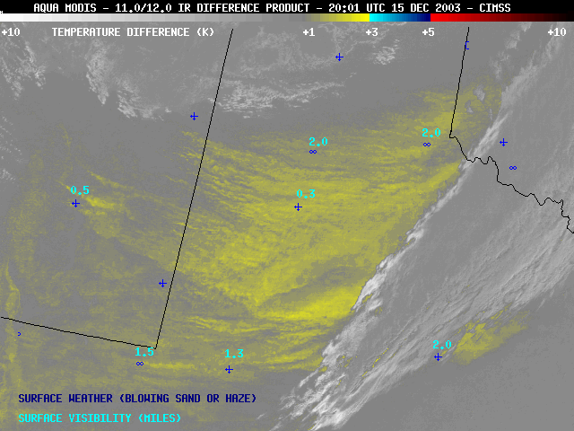 |
Imagery from the Geostationary Operation Environmental Satellite (the GOES-10 “split-window” InfraRed difference product) showed that much of this airborne dust was rapidly transported northeastward to the Great Lakes region within 24 hours, where several reports of “red rain” were made. “True color” images are available in 1000-meter and 250-meter resolution on the SSEC MODIS Gallery. |
Tom Skilling, meteorologist at Chicago’s WGN channel 9, used the image in his nightly weathercast after Chicago drivers also found red dust on their cars. Researcher Wayne Feltz spoke with WIBA’s Katie Austin about the dynamics of the storm that brought the dust to the Midwest. Stories on the Internet documented that dust was seen in Arkansas, Illinois, Wisconsin, Michigan, and Tennessee.
The image was featured on NASA’s Earth Observatory Web site on December 17 and in the emailedNatural Hazards Update on December 22.
Bill Hopkins at the National Weather Service satellite focal point in Lubbock, TX provided ground truth with stunning photos of the storm along with a GOES image for comparison. CIMSS’ Scott Bachmeier followed with an impressive GOES Gallery entry about the storm and its aftermath.
Antarctica
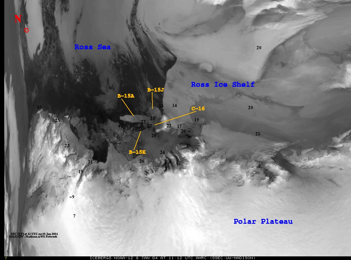
B-15A cracks and breaks … again—On December 15, researchers in SSEC’s Antarctic Meteorological Research Center and Douglas MacAyeal, a University of Chicago glaciologist colleague, noted that B-15A, the longest piece of the mammoth B-15, had cracked again. B-15 broke in two in October. The newest, smaller piece was called B-15J and has moved a little to the northeast of B-15A. The new sliver is called B-15K and is moving south of both pieces, as can be seen in this image from January 7.
Data, Imagery, Software
Bentley Archive—The Digital Library for Earth System Education (DLESE) Reviewed Collection has added The Schwerdtfeger Library’s collection of ice crystals. According to Librarian Jean Phillips, “Over the past 8–10 months, our Bentley site has been reviewed by specialists (scientific and pedagogical) selected by the CRS [Community Review System] editorial review board and by community reviews gathered via the World Wide Web from educators who have used the resource for teaching, learning or research.” More about the topic is on the Library’s Web site.
Appreciation—Bill Lagerroos appreciates SSEC’s Local Weather page for its help in planning his weather-related activities. Writing on December 11, he says, “I spent a bit of time watching the 1 km and 2 km radar displays on 12/10, one reason being that I was curious to know when I should start removing snow. Sure enough, when the trailing edge of the storm got close to Madison on the map, the snow slowed down, then stopped. Such a service, provided by SSEC is helpful to friends who also shovel, and to whom I sent some web info. I also sent it to folks in the Verona school system. Kids will get to see the relationship between your imagery, and what is really happening as they look out the window.”
Jorge Chira, Director of Synoptic Meteorology at Peru’s Meteorological and Hydrological Weather Service, wrote to ask how he could save animations frame by frame. Researcher Tom Whittaker added Java functionality that will allow that. SSEC’s Webmaster Bill Bellon said, “try the Full Disk animations. Click on the ‘Stop’ button and use the < > buttons to go to the image you are interested in and then click on the ‘Show’ button. This will pop up another browser window showing that image. You can then do a ‘File –> Save As’ or right click on the image to save it to your hard drive.” This ability is gradually being added to animations on the SSEC Web site.
Field Experiments and Meetings
CIMSS Annual Board Meeting—The Board of Directors for SSEC’s Cooperative Institute for Meteorological Satellite Studies (CIMSS) met in Madison on December 12, 2003. The Board consists of representatives from NASA’s Goddard Space Flight Center, NASA’s Langley Research Center, the NESDIS Office of Research and Applications, the University of Wisconsin–Madison’s Graduate School, the Space Science and Engineering Center (SSEC), and CIMSS. Presentations summarizing CIMSS science activities are available on CD through CIMSS.
Satellite Data Workshop—In August 2003, a workshop was held to begin to plan and develop new satellite products for current and future data. Aimed at operational weather forecasters, this Workshop on Satellite Data Applications and Information Extraction concentrated on (1) current satellite capabilities and use, especially GOES; (2) capabilities of new and near-future satellites; (3) product displays; and, (4) analytical tools and requirements. This workshop was held in Madison by CIMSS and the Advanced Satellite Products Team (ASPT), in NOAA’s research arm, the National Environmental Satellite, Data, and Information Service’s Office of Research and Applications. Participants came with a variety of backgrounds and included staff from NOAA’s satellite research (NESDIS) and operational forecasting (National Weather Service) arms as well as CIMSS and other academic and government agencies. Organizers Gary Wade and Jeff Key of the ASPT have made their report available on the Web.
DLESE 2004 Annual Meeting—The NSF-funded Digital Library for Earth Science Education (DLESE) will hold its next annual meeting in Madison, Wisconsin this summer. SSEC and its Cooperative Institute for Meteorological Satellite Studies will host the organization, made up primarily of high school earth science teachers. DLESE is an online resource for educators and includes lesson plans. The annual meeting allows the community of users to pool their ideas for future library development.
Planets
Mars Exploration—WIBA Radio’s Mike King interviewed planetary scientist Sanjay Limaye about the successful landing of the U.S.’s Spirit rover on Mars. Limaye also talked about the European Mars Expressmission with its Beagle 2 lander, and the Mars exploration program. Limaye also appeared on Madison’s Fox channel 47 with John Valley, a UW–Madison geophysics professor, and on Madison’s public television weekly news program, Here and Now, anchored by Frederica Freyberg.
Limaye is also quoted in a Mars piece on The Why Files, a UW–Madison on-line publication supported by the National Science Foundation. Asked about the Beagle 2’s failure to “call home,” Limaye noted that the British project was complicated, and “extremely ambitious.” Limaye, a planetary scientist since before Pioneer Venus, spoke about an array of problems facing planetary explorers.
Responding to the news that President Bush is expected to announce a new space initiative, Madison’sWISC-TV (channel 3) interviewed Sanjay Limaye about the challenge of sending humans to Mars. He appeared on the evening newscast, January 9.
Tropical Cyclones
It’s a thrilling event for a researcher when a theorized event appears in nature. CIMSS tropical cyclones scientist James Kossin experienced such a moment when a hurricane feature he had hypothesized appeared in Hurricane Isabel. Briefly, Isabel exhibited mesovortices, shown in a starfish pattern, in the hurricane’s eye. A note on the actual occurrence will appear in the Bulletin of the American Meteorological Society for February 2004. Kossin’s hurricane papers are available on his Web site.
Weather Events
Soot—Chris Schmidt, a researcher in the CIMSS group that monitors biomass burning using the GOES satellite, spoke briefly with reporter Lee Bergquist about the possible role of soot in global warming. ANASA study revealed that “black soot covering ice and snow absorbs sunlight, quickens the melting process and spurs warming.” Schmidt noted that it was important to quantify the data. The issue is very complex, according to team leader Elaine Prins, and the NASA study covers only one aspect.
Weather Experts
Weather Guys—UW–Madison’s Weather Guys Steve Ackerman and Jon Martin appeared Monday, December 29 on WHA Radio, Jim Packard sitting in for Larry Meiller. The Guys answered questions on a wide range of topics, from forecasting the weather three months in advance, large-scale weather features (like the Arctic oscillation), the previous warm season portending global warming, the recent east-coast snow storm portending an ice age, the influence of the jet stream on the weather, the effect of volcanic activity on weather conditions, and many others. Add your voice to their astute audience every last Monday of the month, including January 26. Listen in at 11:45 a.m. either on the Web (The Ideas Network) or the old-fashioned (but reliable) way at 970 AM or 90.7 FM.
Steve Ackerman spoke with Katie Austin, WIBA-AM Radio news, after a strange winter storm over the Christmas weekend. Austin wondered about its connection with global warming. Although a single unseasonable storm does not indicate global warming, the string of “warmest years” continues.
Weather Research
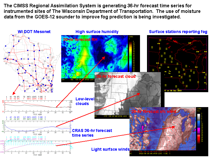
CRAS Forecast Uses Satellite Data to Predict Local and Regional Weather—CIMSS researchers are investigating the possibility of using water vapor and cloud observations from GOES-12 to improve the prediction of fog over Wisconsin roadways. Three-layer precipitable water and cloud-top pressure retrievals from the GOES-12 sounder are being assimilated into the 20-km resolution CIMSS Regional Assimilation System. 36-hour forecast time series are being generated for instrumented sites of the Wisconsin Department of Transportation, which will be used to validate fog forecasts. The CRAS is particularly suited to this task because it is designed to accurately predict the movement of water vapor in the atmosphere. Among the next steps is a surface visibility product that will show areas of fog. Until then, fog must be deduced from relative humidity and other satellite products. Bob Aune (NOAA scientist at SSEC) is encouraged by results for a recent fog event.
At recent workshops held by the U. S. Weather Research Program in Boulder, CO, Aune presented his CRAS modeling work to assess the impact of satellite observation on regional numerical weather prediction, demonstrating that information from satellites can be used locally to improve numerical weather forecasts.
Cloud Typing Algorithm Explained—Michael Pavolonis (SSEC, CIMSS) recently presented two algorithms for detecting cloud overlap and determining cloud type with daytime satellite data at NOAA’s Office of Research and Applications. The first algorithm utilizes spectral channels that are available on the Advanced Very High Resolution Radiometer (AVHRR), and is part of the Extended Clouds from AVHRR (CLAVR-x) processing system. The second algorithm incorporates data from additional spectral channels that are available on the Moderate Resolution Imaging Spectroradiometer (MODIS) and will be available on the Visible/Infrared Imager/Radiometer Suite (VIIRS). VIIRS replaces the AVHRR as the imager on the next generation of NOAA polar-orbiting satellites. Pavolonis develops the algorithms with Andrew Heidinger (NOAA, at SSEC).
AIRS Captures Sulfur Dioxide Event—Both the Atmospheric InfraRed Sounder (AIRS) and the Total Ozone Mapping Spectrometer (TOMS) observed a sulfur dioxide (SO2) plume from the active Soufriere Hills volcano on Montserrat Island in the West Indies as it erupted in July 2003. Tim Schmit (NOAA, at SSEC) found good agreement between a set of AIRS channel differences with (SO2) estimates from TOMS data provided by S. Carn of the University of Maryland, Baltimore County (UMBC). His goal is to understand what a high-spectral resolution sounder will add over the information from a broad-band imager (as suggested by L. Strow, UMBC). Researchers are using AIRS and other weather satellite instruments such as MODIS to see what the next generation of high-spectral resolution sounders and imagers (such as the planned HES/ABI system) will give us. It is also valuable to correlate measurements with the TOMS instrument, which operates in the ultraviolet part of the electromagnetic spectrum. Imager and sounder spectral response functions are compared on the CIMSS GOES pages.
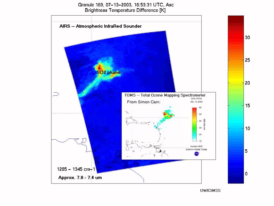
Tracking SO2 plumes is important because they are (to varying degrees) associated with volcanic ash plumes, which can clog the engine of any airplane that flies through them. Scientists also want to understand the transport of SO2 as a trace gas, for example, in relation to air quality.
Honors
Graduate Fellowship Awarded—Robert Holz is the second Suomi-Simpson fellowship recipient and is working towards a Ph.D. in UW–Madison’s Department of Atmospheric and Oceanic Sciences. He will work with researchers in CIMSS (primarily director Steve Ackerman) and NASA’s Goddard Space Flight Center (Matthew McGill) in a project that compares data from three separate sources—SSEC’s Scanning-HIS, Goddard’s Cloud Lidar, and the MODIS Airborne Simulator. It is hoped that this unusual collaboration can exemplify an integrated approach to data analysis and utilization.
Holz and his collaborators will use their findings to answer broad questions about the role of clouds in climate. His particular interest involves assigning cloud heights and learning more about clouds’ radiative transfer—how much heat do they reflect and let through. According to Steve Ackerman, CIMSS director, “Robert Holz is a great candidate. He has lidar expertise and is interested in studying clouds using combined observations from a lidar, an imager and an interferometer.”
Thanks to Steve Ackerman, Leanne Avila, Scott Bachmeier, Bill Bellon, Alexis Johnson, Shelley Knuth, Matthew Lazzara, Sanjay Limaye, Jean Phillips, and Maria Vasys (all of SSEC), Robert Holz (AOS), Robert Aune, Jeff Key, and Tim Schmit (ASPT) who provided help and material for this issue.