Monthly News Summary – October 2003
Isabel Tracked
This issue of SSEC In the News covers news and research results primarily from September 2003. It does not include all news from the month. Use images freely with credit to the Space Science and Engineering Center, University of Wisconsin–Madison, but please notify SSEC’s Public Information Officer.
The CIMSS Tropical Cyclone research group was busy following Hurricane Isabel in September. Real-time satellite products were sent to the National Hurricane Center and the Satellite Analysis Branch in real time to help track the storm. The products included estimates of environmental wind shear, current storm intensity from the latest CIMSS microwave (Advanced Microwave Sounder Unit) and infrared (Advanced Objective Dvorak Technique) algorithms, and vortex wind structure from high-resolution GOES winds adjusted to surface values. The products were acknowledged as critical information by NHC, especially before hurricane hunter aircraft reached the storm.
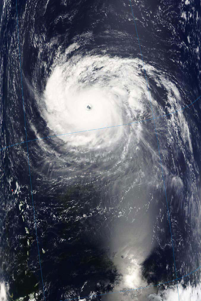 |
The 250m (in left frame) version of this MODIS image shows structure in the eye of Hurricane Isabel that CIMSS’ Jim Kossin had hypothesized in a paper written while working at the National Hurricane Center. |
On September 15, Yahoo published the storm track that CIMSS produces using information from the National Hurricane Center. USA Today used it at the top of their front page, with a nice graphic on the inside, the next day. Local media interviewed Tropical Cyclone’s Chris Velden, Derrick Herndon, and Jim Kossin as the storm threatened land and after it made landfall. Those calling or visiting were WIBA Radio, WISC-TV Madison Channel 3. The office of University Communications sent out a news release, bringing in media from Milwaukee. Television stations 4 and 58 visited. The Milwaukee Journal’s Meg Jones covered the research, starting on the paper’s front page. The article included a good graphical explanation of the storm and a photograph of part of the Tropical Cyclone’s group. The campus newspaper, Wisconsin Week, used a MODIS image of the storm from SSEC’s direct broadcast facility and touted our research. Throughout the storm’s life, especially as it approached the U.S. coast, the National Hurricane Center referred often to CIMSS track and intensity predictions.
 |
A montage of Hurricane Isabel was created with infrared images from the GOES-12 at 11:45 UTC from each of thirteen days, September 7–19, 2003. The sequence shows the evolution and track of Hurricane Isabel in one figure. (Gary Wade, NOAA, at SSEC) |
Antarctica
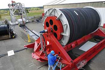
ICDS Activities—WKOW, Madison’s Channel 15; WIBA Radio; and the Badger Herald, a campus student newspaper, covered preparations for IceCube during a media event held Friday, September 19 at UW–Madison’s Physical Sciences Laboratory near Stoughton, Wisconsin. SSEC’s Ice Coring and Drilling Services has constructed the mammoth hose reel holding the hose that will power the hot water drill making deep holes for sensor modules. The hose reel, buildings, and hot water tanks and compressors will all be transported to the Antarctic so that drilling can begin this season. The hot water drill hose reel is shown below, as photographed by Michael Forster Rothbart for Wisconsin Week, September 22.
Medevac—SSEC’s Antarctic Meteorological Research Center assisted in weather forecasting for a medical evacuation from Antarctica. The actual forecasting was done by SPAWAR System Center in Charleston, SC, with assistance from the AMRC, NCAR, and the polar sciences group at Ohio State headed by David Bromwich. USA Today’s Jack Williams used AMRC information, including composite imagery, in his online column.
Polar Media—Polar Press Clips 2003 has been published by NSF’s Office of Polar Programs, Peter West, managing editor. SSEC’s Ice Coring and Drilling Services are mentioned mostly indirectly; wherever holes are drilled, if another group is not specifically noted, almost certainly the ICDS made them. The ICDS’s essential role is noted for two projects and an ICDS employee is noted in a third. The ITASE, or International Trans-Antarctic Scientific Expedition, train is pictured on the publication’s back cover, wending its way across the continent on an ice-coring mission. ITASE studies the progress of global warming using ice cores that show climate change over time. Many articles about ITASE mention ice cores and drilling, and Ernie Mastroianni, writing for the Milwaukee Journal Sentinel, noted the UW contribution in a headline (p.98). An NSF press release notes the role of the ICDS in drilling holes for SPRESO, the South Pole Remote Earth Science Observatory, whose seismometers are about the most sensitive on earth (p.62). Bruce Koci, an ICDS drilling engineer, is mentioned (p.71) in a Science magazine article on Lonnie Thompson’s Ice Core Paleoclimatology Group from Ohio State. Koci is the (then) University of Nebraska engineer that Thompson asked to design a “lighter drill that could be disassembled and powered by solar energy.”
Neutrino News
An article previously published in Letters and Science Today [UW–Madison], Spring 2003 was reproduced in Polar Press Clips 2003 (p. 14). IceCube and AMANDA are featured. Only the first page was published, omitting credit information. The article notes that strings of detectors will “convert a cubic kilometer of South Pole ice into the world’s largest scientific instrument.”
Weather Experts
Weather Guys—Larry Meiller’s WHA Radio show on September 29 began with hurricane questions, leading into a lively hour with Steve Ackerman (director, CIMSS and professor, Atmospheric and Oceanic Sciences) and Jonathan Martin (professor, Atmospheric and Oceanic Sciences). September was surely the month for huricanes. Martin and Ackerman explained that those enormous cyclonic storms are called hurricanes in the Atlantic Ocean and Typhoons in the Pacific, and they explained naming conventions. Until the late 1980s, hurricanes were always given traditionally female names. Some say that hurricane forecasters named the storms after mother-in-laws. Now the names alternate male to female and they are more often given region-appropriate names. As the Guys said, there will be no Hurricane Larry in the Pacific. They also discussed damage due to storm surge, the water that a hurricane leaves behind, and wind speed and wave height. Hurricane Andrew, for example, at one point had 150 mph winds, probably before landfall. A caller noted that Pacific Ocean typhoon waves washed across the 90-foot deck of his aircraft carrier. They also discussed the storm’s huge pressure difference from the middle to its edges, causing the strong winds. The storms move slowly, though, because they’re not connected to any existing flows.
Weather Research
Software Aid to Mexico’s Water Commission—SSEC and the Man computer Interactive Data Access System (McIDAS) User’s Group (MUG) are supporting Mexico’s Comisión Nacional del Agua (CNA) in the installation of McIDAS software until CNA becomes an official MUG member in 2004. Robert Masters of the U.S. National Weather Service (NWS) requested the assistance in support of the NWS agreement with CNA to transfer meteorological and hydrological software to Mexico. CNA will run the Hydro-Estimator, which requires the McIDAS environment.
Fire Products for South American University—The GOES biomass burning monitoring team at CIMSS recently responded to a request by D. Selhorst (Universidade Federal do Acre – Parque Zoobotânico) for satellite observations of fires in Rondonia, Brazi,l and Bolivia for the dates of August 31–September 5, 2003. Heavy smoke covered the Rio Branco region of Brazil as shown in D. Selhorst’s photo. The GOES Wildfire Automated Biomass Burning Algorithm (WF_ABBA) alpha-blended composites verified burning in the Rondonia and Bolivia regions and also smoke over the Rio Branco region. Alphablending is a technique in which a semitransparent image is overlaid onto another image. Since the appearance of thin to moderate smoke is often masked in the current alpha-blending technique, the appearance of smoke in the WF_ABBA alpha-blended imagery is significant.
 |
This alpha-blended (layered) composite image shows fires detected with the GOES-12 WF_ABBA on September 3, 2003 at 15:15 UTC. The inset is a photo taken in Rio Branco, Brazil showing heavy smoke coverage in the region. |
GOES Wildfire ABBA Validation Study in Quebec—Joleen Feltz and Chris Schmidt (in SSEC’s CIMSS) and Elaine Prins (NOAA/NESDIS, assigned to SSEC) have collaborated for several years with M. Moreau in Environment Canada/Meteorological Services/Quebec Region to develop fire detection products for the region, using the the Geostationary Operational Environmental Satellite Wildfire Automated Biomass Burning Algorithm (WF_ABBA). They compared fire products for the 2002 fire season with ground truth information provided by SOPFEU (SOciété de Protection des forêts contre le FEU), Quebec’s forest fire detection and prevention agency. When considering fires that burned more than 10 hectares, the ABBA detected 91 out of 111 reported fires and a number of additional remote fires located above 50 degrees north where there is no systematic daily reporting. In one case, outside of the intensive protection zone, the WF_ABBA detected a fire 17 days in advance of the first fire agency report; this fire eventually burned about 136,000 acres. While SOPFEU neither has a mandate to regularily monitor this area nor does it attempt to extinguish fires which do not threaten native communities or human installations in this region, this study shows the usefulness of diurnal remote sensing fire products in remote areas at northerly latitudes.
 |
This composite image shows fires that were detected by the WF_ABBA using GOES-8 data in Quebec, Canada at 17:45 UTC on July 6, 2002 prior to the initial fire agency report. These fires are located in the restricted protective zone of Quebec, where there is no daily systematic detection capability. |
Papers, Presentations
Where SSEC staff or students are first through third authors, or, if not, the contributions are substantial.
The CIMSS Biomass Burning Detection group has submitted extended abstracts to the 2nd International Wildland Fire Ecology and Fire Management Congress, part of the American Meteorological Society’s (AMS) 5th Symposium on Fire and Forest Meteorology to be held November 16-20, 2003 in Orlando, Florida:
- “Recent validation studies of the GOES Wildfire Automated Biomass Burning Algorithm (WF_ABBA) in North and South America” was submitted by Joleen Feltz, Michel Moreau (Environment Canada/Meteorological Services/Quebec region), Elaine M. Prins, Kirsten McClaid-Cook (State University of New York-SUNY, Albany), and Irving F. Brown (Woods Hole Research Center, Federal University of Acre, Brazil). It describes a validation study which is part of an international collaborative effort.
- “GOES Wildfire ABBA Applications in the Western Hemisphere,” submitted by Christopher C. Schmidt and Elaine M. Prins, discusses the WF_ABBA algorithm, its output, and the efforts to reduce the time it takes to produce the product.
With first author J. Reid (Naval Research Laboratory, Monterey), Elaine Prins (NOAA team leader of CIMSS’ Biomass Burning Detection group) has submitted “Modeling and Mechanisms of Intercontinental Transport of Biomass-Burning Plumes” to the fall American Geophysical Union (AGU) meeting to be held in San Francisco, December 8–12, 2003. The paper provides an overview of recent research activities associated with Fire Locating and Modeling of Burning Emissions (FLAMBE, http://www.nrlmry.navy.mil/flambe/index.html), a project sponsored jointly by the U.S. Navy, NASA, and NOAA that provides 5-day forecasts of large biomass burning plumes with applications to air quality, visibility, and regional radiative balance studies. The AGU presentation will discuss and compare the mechanisms of intercontinental transport from the three most important sources in the world prone to long range advection: Africa, South/Central America, and Siberia.
“Real-time monitoring of South American smoke particle emissions and transport using a coupled remote sensing/box-model approach” by Reid et al. was submitted to the journal Geophysical Research Letters. The paper summarizes research conducted under FLAMBE to monitor biomass burning emissions based on assimilating geostationary weather satellite (GOES) fire products made with the CIMSS Wildfire Automated Biomass Burning Algorithm (WF_ABBA) into the Naval Research Laboratory Aerosol Analysis and Prediction System. The paper shows that GOES satellite-derived fire products are adequate for generating real-time smoke source functions for aerosol forecast models. E. Prins (NOAA, with SSEC) and C. Schmidt (CIMSS) are among the co-authors.
Jun Li and Fengying Sun (CIMSS) and W. Paul Menzel and Timothy J. Schmit (NOAA, with SSEC) have submitted an abstract to the American Geophysical Union (AGU) Fall Meeting Aqua Special Session, “Early Results from NASA’s Earth Observing System Aqua Spacecraft Mission” (December 2003, San Francisco). The title is “Synergistic use of MODerate-resolution Imaging Spectroradiometer cloud products and AIRS radiance measurements for retrieval of cloud parameters.”
Bormin Huang (CIMSS) presented “Data Compression Studies for NOAA Hyperspectral Environmental Suite (HES) using 3D Integer Wavelet Transforms with 3D Set Partitioning in Hierarchical Trees” at the Society of Photo-optical Instrumentation Engineers (SPIE)’s 2003 International Symposium on Remote Sensing, September 8–12, in Barcelona, Spain. Co-authors with Huang include Hung-Lung Huang, Hao Chen, Alok Ahuja, and Kevin Baggett, all of CIMSS; Timothy J. Schmit (NOAA, at SSEC), and Roger W. Heymann.
“Rapid Day-time Estimation of Cloud Properties over a Large Area from Radiance Distributions” by Andrew K. Heidinger appeared in September in the Journal of Atmospheric and Oceanic Technology. The paper outlines the daytime algorithm used in Clouds from AVHRR extended system (CLAVR-x). The algorithm is unique in that it retrieves cloud properties for a grid cell from the distribution of the observations from many cloudy pixels. This results in a very fast method that appears to suffer little loss in accuracy compared to more rigorous and much slower pixel-by-pixel retrievals.
“A study of the Antarctic surface energy budget using a coupled regional climate model forced with satellite-derived cloud properties” was accepted for publication in Monthly Weather Review. The paper, by Michael Pavolonis (CIMSS), Jeff Key (NOAA, at SSEC) and J. Cassano (University of Colorado), describes a study where cloud information derived from satellite data was used to modify the moisture field in a regional atmosphere-ocean-land model over Antarctica.
A manuscript concerning the relative merits of the 3.75 and 1.6 micron channels on the NOAA Advanced Very High Resolution Radiometer (AVHRR) for cloud detection was accepted for publication in the Canadian Journal of Remote Sensing. The AVHRR has traditionally possessed only the 3.75 micron channel but newer versions have the option to replace the 3.75 micron channel with the 1.6 micron channel. This change significantly alters the cloud detection sensitivity in some scenarios; this impact is discussed in the paper. Authors are A. Heidinger (NOAA, at SSEC) and R. Frey and M. Pavolonis, CIMSS.
Education, Outreach
SSEC Forecasts for Football Weather Hazards
by Wayne Feltz
Several SSEC employees have volunteered their time to forecast for hazardous weather during the University of Wisconsin home football games. Lightning, excessive heat, high winds, and heavy precipitation are the main forecast concerns during the games. This is the second year that SSEC has provided forecasts and near real-time nowcasts to Captain Dale G. Burke of the UW–Madison police. The forecasts were requested after severe lightning occurred two years ago during the Virginia-Wisconsin game and more than 2 inches of rain fell in a one-hour period. During the same season a chemical spill on campus caused concern and wind information would have been useful. Tom Achtor, SSEC’s Executive Director for Science, has been the main contact for this effort. Currently, Wayne Feltz is forecasting for the Ohio State-Wisconsin game at 8 p.m. Saturday evening, October 4. The image (below) contains a plot of weather model data indicating heavy rain and possible lightning (purple/green colors) during a strong cold frontal passage valid at the time of the football game kickoff. This is a four-day forecast, however; and Feltz will remain in touch with Capt. Burke as the week progresses to provide the most up-to-date hazardous weather forecasts. GGOOO BUCKY!!
 |
This model image, produced by the Department of Atmospheric and Oceanic Sciences, is valid at 7 p.m. Saturday evening. It shows a front that passes through Madison during game time.(Wayne Feltz, CIMSS) |
Thanks to Chris Velden and Jeff Key and other ASPB members for content, Bill Bellon and Brian Kayon for technical support, and Bob Aune.