Monthly News Summary – August 2003
Neutrinos Mapped for Northern Sky
This issue of SSEC In the News covers news and research results primarily from July into August 2003. Use images freely with credit to the Space Science and Engineering Center, University of Wisconsin–Madison, but please notify SSEC’s Public Information Officer.
Results from the South Pole based Antarctic Muon and Neutrino Detector Array (AMANDA) were presented before astronomers in Sydney, Australia in July. With a neutrino sky map, Francis Halzen, UW–Madison physicist who devised the idea of an ice-bound telescope, made the case for a larger telescope at the General Assembly of the International Astronomical Union. Terry Devitt of UW–Madison’s Communications office released results to the media on July 15. Devitt explained that “the AMANDA II (Antarctic Muon and Neutrino Detector Array) Telescope is designed to look not up, but down, through the Earth to the sky in the Northern Hemisphere.” The preliminary map of the northern sky produced using AMANDA II represents one year of data. With another two years of AMANDA II data, Halzen and his team will “define the structure of the sky map and sort out potential signals from statistical fluctuations in the present map to confirm or disprove them.”
 |
The first map of the high-energy neutrino sky, produced with data from the AMANDA II Telescope at the South Pole |
According to Halzen, the preliminary map proves that the detector works. “It establishes the performance of the technology and it shows that we have reached the same sensitivity as telescopes used to detect gamma rays in the same high-energy region” of the electromagnetic spectrum. AMANDA, and the planned IceCube, a many times larger version, are funded by the National Science Foundation.
BBCi featured the AMANDA results in BBC News Online. David Whitehouse, science editor, noted that, “In the sky map, Amanda 2 has detected neutrinos that have up to one hundred times the energy of neutrinos generated by the most powerful earthbound particle accelerators. This raises the hope that some of them may reveal the most energetic events in the cosmos.”Wisconsin Week Wire published the news on July 16.
The Universe Today, a science blog (Web log), featured the telescope and map on July 16, noting that AMANDA II “discovered neutrinos with 100 times the energy of any produced in laboratory experiments on Earth.” Aviation Week and Space Technology, July 21, published the neutrino map and noted its significance on p. 17 in the “In Orbit” section. The Milwaukee Journal Sentinel featured the AMANDA results on July 21 in its Monday Health and Science section. John Fauber noted that detecting neutrinos was the first step in unlocking the mysteries of the universe’s more violent events, such as its beginning, and the death throes of stars. The Madison Capital Times newspaper used Frank Roylance’s article from the Baltimore Sun, and noted that Halzen proposed the ice-bound telescope because ice makes it possible to detect high-energy neutrinos, unlike water and media through which mostly low-energy neutrinos can be detected. In Australia’s ABC Science Online Alex Bannigan remarked upon the neutrino’s role as cosmic messenger: “Because they have no charge, almost no mass, and are invisible, they are able to pass through space, planets and stars without their path being altered by magnetic fields or physical obstacles. That means that the information that they carry about distant events remains intact throughout their journey.” The Alien Online, another science blog, noted that AMANDA’s array of bowling-ball-sized detectors “transforms a cylinder of ice 500 meters high and 120 meters diameter into a particle detector.” The Discovery Channel (July 22) noted on line that high-energy neutrinos are so rare that AMANDA II would be lucky to find 10 of them a year; IceCube multiplies the possibilities many times.
In Australia’s Science Daily (July 24) Francis Halzen said of AMANDA, “To date, this is the most sensitive way ever to look at the high-energy neutrino sky.” On July 29, in its “Science Times,” The New York Times’ Dennis Overbye compared different ways of seeing the universe presented at Sydney’s astronomers’ conference, including AMANDA. Overbye noted that UW–Madison’s neutrino map “shows the northern sky … speckled with neutrino sources.” The International Herald Tribune (July 31) used’s article in the which Pakistan’s on-line Daily Times (August 12) used Overbye’s article.
Jim Green, a mechanical engineer in SSEC’s Ice Coring and Drilling Services, appeared on WORT-FM radio’s 8 O’clock Buzz Friday morning, August 8. He answered Jonathan Zarov’s questions about ice coring in general, but especially about the neutrino telescopes AMANDA and IceCube, now in the planning stages. He also talked about the huge hot water drill that UW-Madison’s SSEC has designed and that the Physical Sciences Lab is currently constructing to make IceCube and other deep coring projects a reality.
For More Information
Data and Imagery
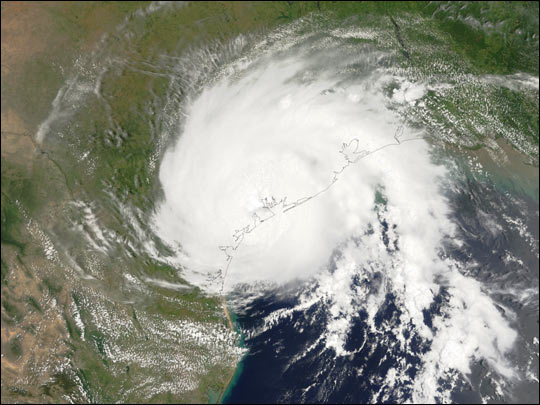 Beginning July 17, SSEC’s direct broadcast facility started using 500 or 250 meter resolution data (instead of the lower resolution 1000 meter resolution) to create Aqua MODIS true-color images: Hurricanes—An image of Hurricane Claudette was captured by the NASA Terra satellite using the MODIS instrument as the hurricane came ashore in Texas on July 15. The image was used on the home pages of NASA’s Goddard Space Flight Center, in NASA’s Earth Observatory Web site, and on NASA’s home page. See “Life on Earth,” July 17, “Eye to Eye with Hurricane Claudette.”
For example, see the image named ‘New York City NY Hi-Res.’ The quality of the images is significantly improved.
To see if the browse image used 500 or 250 meter resolution data, look at the image file name that appears in your browser address bar. The image name will end with ‘1KM.jpg,’ ‘HKM.jpg,’ or ‘QKM.jpg,’ which stands for 1000, 500, and 250 meter resolution, respectively.
The Sea—SSEC’s Sea Surface Temperature composite image is used in the headline banner of images, labeled “Observations to Users to Benefits,” on the Earth Observation Summit page. Hit the scroll left button to see it. The McIDAS Team’s rotating globe forms the “O” in Observation at the left. The summit was held July 31 to “Promote the development of an integrated Earth observation system among governments and the international community… .”
Field Experiments and Meetings
IGARSS—In their news release of July 17, NASA announced seven presentations of “particular interest” given by NASA-funded scientists at the International Geoscience and Remote Sensing Symposium (IGARSS) given in Toulouse, France, in July. Top on the list is John Norman, a UW–Madison soils scientist and long-time SSEC collaborator. Norman discussed how researchers, including SSEC’s John Mecikalski and Martha Anderson (formerly with Soil Science), developed a two-tier method for estimating evaporation from plants and soil. His talk described procedures for conducting observations and presented validation data demonstrating the usefulness of this method. IGARSS was organized and sponsored by the IEEE Geoscience and Remote Sensing Society and other organizations.
Instrument Development
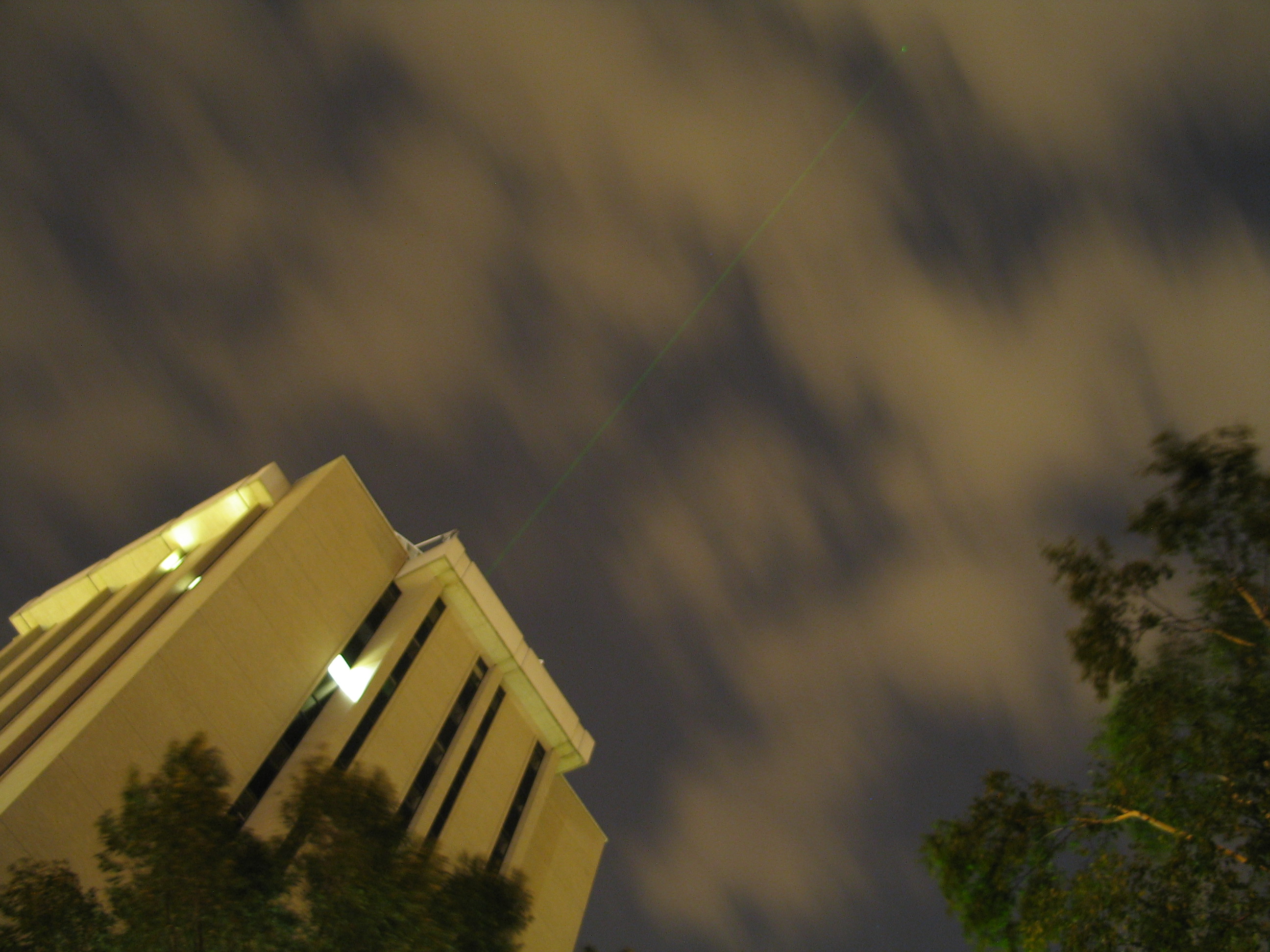 |
If you look carefully, especially in the larger image, you can see a ghostly green beam of light shooting up diagonally from the top of the building. It’s actually beamed through a skylight from a new lidar instrument being developed by SSEC. |
UW Lidar—In the dark of night, the High Spectral Resolution Lidar sends up a greenish beam of light from the roof of the Atmospheric, Oceanic and Space Sciences Building. The instrument is being tested before being sent to the Arctic Circle near Barrow, Alaska where it will gather detailed information about the atmosphere. The data will be used in numerical models to study climate change. Lidars like this one have been developed by Edwin Eloranta’s UW–Madison group since the 1970s and have been used primarily during field experiments, where they are constantly attended. This is the first such instrument intended to be left in a location for a year with only occasional monitoring.
Planets
The Neptune findings of Larry Sromovsky and other planetary scientists appeared in the May/June 2003 issue of The Planetary Report in “Factinos,” with other research snippets. The magazine used the 15-image picture showing 5 images each from 1996, 1998 and 2002.
Polar Science
Polar Winds Transfer to Operations Begun—CIMSS makes a real-time product to show winds in the polar regions from Moderate Resolution Imaging Spectroradiometer (MODIS) data. Scientists Jeff Key (NOAA/NESDIS team leader at SSEC), and Dave Santek and Chris Velden (CIMSS) and J.Daniels (NOAA/NESDIS) have made the first step in the process of transferring the product from CIMSS research to NESDIS forecast operations by transferring the software to NOAA’s Forecast Products Development Team (FPDT) so that the code can be run in parallel with CIMSS. Though the transition to NESDIS operations is not scheduled until fiscal year 2005, this first preparatory step has already been taken. Software differences at CIMSS and FPDT have been identified and test cases have been run.
Software
McIDAS 2003 Upgrade—In development since 1970, McIDAS, SSEC’s first visualization software for the Earth sciences is still one of the most flexible software packages for displaying and analyzing satellite and other forms of weather data. McIDAS, or the Man computer Interactive Data Access System, provides a flexible system making it the tool of choice for international government agencies, research centers, and corporations. In its annual upgrades, SSEC‘s McIDAS team strives to keep pace with the rapidly evolving world of satellite and weather data. Changes included in the 2003 McIDAS upgrade improve access to low-earth orbiting satellite data, including MODIS, and a more intuitive user interface.
Tracking Fires
Fire Products for Smoke Study—Elaine Prins (NOAA) and Chris Schmidt (CIMSS) provided GOES enhanced imagery and half-hourly fire products from the Wildfire Automated Biomass Burning Algorithm (WF_ABBA) to A. Langford of NOAA’s Aeronomy Laboratory for a smoke analysis and transport study for July 8-9, 2002. Data from LIDAR in Boulder detected multiple layers of smoke including a significant layer in the upper atmosphere. The GOES imagery and fire products will be used to determine sources of the smoke and to examine possible lofting mechanisms.
GOES WF_ABBA Fire Product Now Ready Sooner—The hazards community and fire weather forecasters requested that CIMSS fire products be made available more quickly. Chris Schmidt (CIMSS) and Elaine Prins (NOAA/NESDIS) have modified their algorithm so that GOES-12 WF_ABBA fire product ASCII files are now available via anonymous ftp within 20-25 minutes from the time that GOES-12 takes the image. The composite fire imagery is available on the Web within about 30 minutes. CIMSS hopes to have the products available even more quickly in the next few months by implementing the WF_ABBA on new hardware.
Weather Research
A New GOES-12 Test—SSEC’s Data Center helped evaluate test data from the Modernized Sensor Processing System on GOES-12, transmitted through GOES-11. The Data Center pointed their backup antenna at GOES-11, activated a backup SSEC Desktop Ingestor, and archived several days of raw data. Tim Schmit (NOAA/NESDIS, at SSEC) Jerry Robaidek (SSEC Data Center supervisor), and Mat Gunshor (CIMSS) evaluated the test data and presented it to Keith McKenzie, in the NOAA/NESDIS Office of Systems Development. Delores Wade manages the SSEC Data Center.
NCEP Forecast Model Uses GOES Sounder Cloud Information—On July 8, the hourly cloud-top information from the GOES sounder instrument began to be assimilated into the model used routinely by the National Centers for Environmental Prediction (NCEP). The regional Eta Data Assimilation System (EDAS) and the Rapid Update Cycle (RUC) model are now the only two operational models assimilating GOES sounder cloud information to help improve initial moisture and cloud field portions of the model. GOES-12 sounder radiances are currently being tested for fall implementation by the EDAS. Scientists on the project are Jim Jung (CIMSS, in D.C.), Tony Schreiner (CIMSS, at SSEC), Y. Lin (NCEP), and Tim Schmit and Robert Aune (NOAA/NESDIS, at SSEC).
New Cloud Initialization Technique Uses GOES Sounder—Robert Aune (NOAA/NESDIS, at SSEC) and Tony Schreiner (CIMSS) have devised a technique to initialize multilayer clouds using cloud information from the GOES sounder instruments for use in the CIMSS Regional Assimilation System (CRAS). Because so many variables are combined to model the weather, it is extremely important that the observations that make up “initial conditions” be accurate. Single field-of-view cloud-top pressure and effective cloud amount, retrieved from GOES sounder radiances, are mapped onto the 3-dimensional model grid and checked for radiative consistency. This allows thinner clouds to be included at multiple levels which leads to improved surface heat flux measurements. The previous method allowed only thick clouds in the model grid and at only two levels.
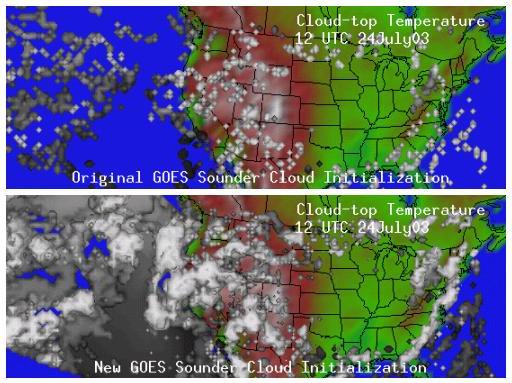
The top image shows cloud-top temperature (in degrees Kelvin) in the 61 kilometer CRAS grid computed from the model cloud mass field generated from cloud-top pressure and effective cloud amount derived from GOES-10 and -12 sounder information. Model temperatures are mapped onto the cloud mixing ratio iso-surfaces (where the ratio is the same) to indicate the height of the cloud top (white indicates cold; gray, warm). The new technique (bottom) allows thinner, multilayer clouds to be included in the analysis.
Papers
SSEC and SSEC-affiliates are authors on three papers published in IEEE Transactions on Geoscience and Remote Sensing, February 2003 (Vol. 41, No. 2) in a special issue on NASA’s Aqua satellite.
- “The MODIS Cloud Products: Algorithms and Examples From Terra” was written by Steven Platnick (NASA/GSFC), Michael D. King (NASA/GSFC), Steven A. Ackerman (director, SSEC’s Cooperative Institute for Meteorological Satellite Studies), W. Paul Menzel (NOAA/NESDIS/ORA Chief Scientist, stationed at SSEC), Bryan A. Baum (NASA/LaRC, stationed at SSEC), Jérôme C. Riédi (NASA/GSFC), and Richard A. Frey (SSEC/CIMSS) and reports on the algorithms developed to detect clouds and to retrieve physical and optical cloud properties.
- “Cloud and Aerosol Properties, Precipitable Water, and Profiles of Temperature and Water Vapor from MODIS” describes each MODIS data product from the NASA Terra satellite and compares the data products with those to be produced from Aqua. Authors are Michael D. King, W. Paul Menzel, Yoram J. Kaufman (NASA GSFC), Didier Tanré (Laboratoire d’Optique Atmosphérique,Université des Sciences et Technologies de Lille/CNRS), Bo-Cai Gao (NRL), Steven Platnick, Steven A. Ackerman, Lorraine A. Remer (NASA), Robert Pincus (NOAA/Climate Diagnostics/CIRES), and Paul A. Hubanks (SSAI).
- “Cloud-drift and Water Vapor Winds in the Polar Regions from MODIS” was written by Jeffrey R. Key (NOAA/NESDIS Team Leader at SSEC) David Santek (SSEC), Christopher Velden (CIMSS), N. Bormann (European Centre for Medium-Range Weather Forecasts, ECMWF), J.-N. Thepaut (ECMWF), L.P. Riishojgaard (Data Assimilation Office, DAO), Y. Zhu (DAO), and W.Paul Menzel (ORA). The paper describes how wind information can be obtained from MODIS data and provides results from model impact studies at ECMWF and DAO.
- In that same issue, David Tobin and Hank Revercomb contributed to “AIRS/AMSU/HSB Validation.”
The Journal of Applied Meteorology published
- “Antarctic Cloud Radiative Forcing at the Surface Estimated from the AVHRR Polar Pathfinder and ISCCP D1 Datasets, 1985-1993” by Michael J. Pavolonis (SSEC) and Jeffrey R. Key (vol. 42 no. 6)
- “Nighttime multilayered cloud detection using MODIS and ARM data” by Bryan A. Baum, Richard A. Frey, Gerald G. Mace, Monica K Harkey, and Ping Yang (vol. 42, no.7)
- “ Rapid scan AERI observations: Benefits and analysis” was published in the Proceedings of the Thirteenth Atmospheric Radiation Measurement (ARM) Science Team Meeting, Broomfield, CO, 31 March–4 April 2003. Authors are SSEC’s Wayne Feltz, David Turner, Robert Knuteson, and Ralph Dedecker.
SSEC scientists presented many papers at the meeting for Optical Remote Sensing of the Atmosphere and Clouds III held in Hangzhou, China, 25-27 October 2002. The International Society for Optical Engineering (SPIE) has recently published the proceedings.
- “Software packages for direct broadcast data processing of ATOVS, MODIS and AIRS radiances” was written by Thomas Achtor, Allen Huang, Liam Gumley, Jun Li, and Hal Woolf.
- “Validation of aircraft-measured land surface emissivity” was written by Daniel H. DeSlover, Robert O. Knuteson, Brian Osborne, Daniel K. Zhou, and William L. Smith. All are with SSEC but for Zhou and Smith (Langley Research Center).
- “Hyperspectral radiance simulator—cloud radiance modeling and beyond” was written by Allen Huang, Dave Tobin, Jun Li, Erik Olson, Kevin Baggett, Bormin Huang, John Mecikalski, Bob Knuteson, Brian Osborne, Derek Posselt, Paolo Antonelli, Hank Revercomb, William Smith, and Ping Yang.
- “Generalized radiative transfer equation for multilevel clouds” by Bormin Huang, Allen Huang, and William L. Smith
- “Boundary layer moisture retrieval from Indian Ocean METOC Imaging (IOMI) mission for Geostationary Imaging Fourier Transform Spectrometer (GIFTS)” by Jun Li and Allen Huang
- “MODIS direct broadcast products and applications” by Kathleen I. Strabala, Liam E. Gumley, Thomas Rink, Allen Huang, and Russ Dengel
- “Carbon monoxide and methane column retrieval from the Scanning High Resolution Interferometer Sounder (S-HIS) and National Polar-orbiting Operational Environmental Satellite System Airborne Sounder Testbed- Interferometer (NAST-I)” by , Kenneth H Vinson, Henry E. Revercomb, H. Benjamin Howell, Robert O. Knuteson, and William L.Smith.
The Journal of Geophysical Research-Atmospheres has accepted “Combining radio occultation refractivities and IR/MW radiances to derive temperature and moisture profiles: a simulation study plus early results using CHAMP and ATOVS” for publication in a forthcoming issue. Co-authors are Eva Borbas (CIMSS), W. Paul Menzel (NOAA/NESDIS, at SSEC), and Jun Li and Hal Woolf (CIMSS).
Three abstracts were submitted for the 2004 annual American Meteorological Society meeting, all covering development work for the next series of GOES. The titles are: “Study of the Advanced Baseline Imager (ABI) on the Geostationary Operational Environmental Satellite (GOES)-R and beyond,” “Study of the Hyperspectral Environmental Suite (HES) on the GOES-R and beyond” and “HES Simulation Study using Cube Data from MM5.” Authors include: Jun Li, Fengying Sun, Mat M. Gunshor, Chris C. Schmidt, W. Paul Menzel, James Gurka, Justin Sieglaff, Derek Posselt and Timothy J. Schmit.
Education, Outreach
Summer Workshops for K–12—UW–Madison held its 2003 Summer Workshop on Atmospheric, Earth, and Space Sciences for High School Students from July 27–31. Hosted and sponsored primarily by SSEC’s Cooperative Institute for Meteorological Satellite Studies (CIMSS), the workshop draws upon resources from across the university: the Department of Atmospheric and Oceanic Sciences, SSEC (Space Science and Engineering Center), and the Department of Astronomy’s Space Astronomy Laboratory, as well as the Geology department at UW–Richland Center and the Wisconsin Space Grant Consortium, housed at UW–Green Bay. In the past, one workshop was held for students and teachers; this year two separate workshops were given. Participating students interacted directly with scientists in a variety of interactive activities. Among this year’s topics were meteorological measurements, thunderstorms, McIDAS use, forecasting taught at the Sullivan office of the National Weather Service, remote sensing from airplanes and satellites, Antarctic weather, tropical cyclones, lake water clarity, astronomy. The workshop concluded with an energetic field trip to the Baraboo area for a study of geologic formation. See the Workshop Page for pictures and descriptions of the workshop weather.
Satellite Meteorology and GLOBE Courses—Twenty teachers from four different states visited SSEC in July for workshops on Satellite Meteorology and GLOBE, the Global Learning and Observations to Benefit the Environment program.
CIMSS’ 2-day teacher workshop on Satellite Meteorology for Grades 7–12 drew sixteen teachers and was supported by the Wisconsin Space Grant Consortium. Attendees teach 7th grade general science, more advanced physics and chemistry courses, Earth science and aerospace. Course offerings included a meteorology refresher, satellite imagery used in hurricane studies, and Java applets for teaching. John Eise, a senior forecaster with the National Weather Service at Sullivan showed how satellite imagery is used in forecasting. Eise gave insight into how forecasters and researchers use weather satellite data; demonstrated different enhancements and their uses; and showed the main data types, including water vapor. He explained the role of the sun as the heat engine that drives the weather and explained how models are built and used. He noted that satellite imagery is useful not only for forecasting but for search and rescue operations. Also as part of the course, the teachers learned from and gave feedback on a CIMSS-designed CD on satellite meteorology and told how they would use the material in their classes.Evaluation sheets showed that they were very happy with the course and gave valuable comments.
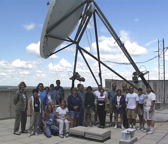 |
Teacher participants of the Satellite Meteorology course pose with SSEC staff before the antenna receiving weather satellite data on the roof of the Atmospheric, Oceanic and Space Sciences building. |
Most teachers stayed for the GLOBE Workshop on July 24, when the atmosphere protocol was presented. SSEC’s OSSE gives many GLOBE workshops throughout the year. Information on past and future workshops is posted on the Web site.
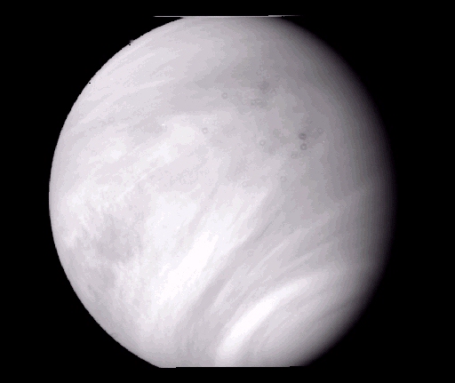
SHARP Students—Three high school student apprentices gave up weeks of precious summer time to work with SSEC scientists. C. J. Rivenbak and Ashley Minor reported on their research. C. J. Rivenbak’s project provided important calibration information for scientists analyzing images from the 1974 Mariner 10 mission to Venus. Rivenbak removed “all the errors in the actual image to make it more presentable and [to be] able to see the distinct characteristics of the image.” He also removed “the geometric distortion that occurs from the camera lens and focusing.” Rivenbak learned that “Mariner 10 took the only ultraviolet images of Venus providing contrast in the atmosphere.” His project will provide needed information for a proposal to revisit Venus and “could lead to more accurate and updated information using better technology.” Below is one of his images of Venus.
Ashley Minor studied hurricane intensity estimations using satellite data. Minor wished “to gain an understanding of the intensity of tropical hurricanes from satellite imagery, … produced from recorded storms.” She used a “system of categorizing the different features of the hurricanes … to test whether they correlate with intensity.” She found “that throughout the evolution of hurricanes, the more organized their convection is [and] the more intense the storm will be.” Her calculations will enable scientists to “calculate hurricane intensity when they are unable to monitor the storm by aircraft.”
Amazing Mars—Besides their work at SSEC, all three students worked on a joint Mars project with all the SHARP apprentices at UW–Madison. According to Ashley Minor, “The group conducted a project on the [possibility of] success of establishing a permanent settlement on Mars.” The closest approach in recorded history between Mars and Earth occurs on August 27. Indeed, Mars is so close now, in mid-August, that you can see the polar ice caps with a good home telescope.
Physics of Star Trek lecture—Professor Lawrence Krauss, Chair of the the Department of Physics at Cleveland’s Case Western Reserve University, gave a very well-received public lecture Tuesday, August 12 at UW Space Place, the university’s space-oriented museum and outreach center. The author of The Physics of Star Trek and many other books that make science intelligible to scientists and nonscientists alike, Krauss guided the audience “on a warp speed journey through the Star Trek universe.” Through his props and video clips, as well as wit and charm, in an hour and a half, he covered time travel (with a homemade time machine), warp drive, the search for extra-terrestrial intelligence, as well as Star Trek’s use and misuse of the laws of physics. Professor Krauss also featured selections from his Top Ten Star Trek Physics Bloopers. Professor Krauss talked about complicated things, intelligibly, and kept a (mostly) nonscientist audience laughing almost the entire time. Find the book or his later Beyond Star Trek and you will not only be entertained but you may learn something.
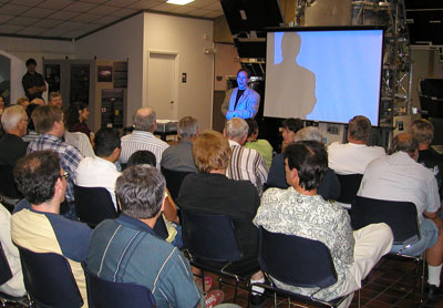 |
Lawrence Krauss speaks to a standing-room-only crowd at Space Place on August 12, 2003.Photo by Sanjay Limaye |
While in Madison, Krauss also spoke to attendees of the Teaching Space Science workshop, hosted by SSEC’s Office of Space Science Education. Jatila Van der Veen of the University of California at Santa Barbara is conducting much of the workshop, with Sanjay Limaye (director, OSSE), Wilton Sanders (Space Physics Group and SSEC), and Rosalyn Pertzborn (SSEC).
Thanks to Jeff Key, Margaret Mooney and Sanjay Limaye; and to Brian Kayon and Bill Bellon for technical assistance. To define or explain some terms, I used the textbook, Meteorology—Understanding the Atmosphere, by Steven A. Ackerman and John A. Knox, 2002, Thomson-Brooks/Cole, particularly for the part on numerical weather models (p.376f).