Monthly News Summary – July 2003
SSEC’s New Web Offerings
This issue of SSEC In the News covers news and research results primarily from June into July 2003. Aslo be sure to read In the Wings for an important forthcoming public lecture. Use images freely with credit to the Space Science and Engineering Center, University of Wisconsin–Madison, but please notify SSEC’s Public Information Officer.
SSEC has added some new pages to its Web site. You may not find them unless you know what you’re seeking, so here are highlights. Also included are some old favorites with new information.
New Rooftop Instrument Suite—SSEC has collaborated with our collocated colleagues in the Department of Atmospheric and Oceanic Sciences in a new set of atmospheric instruments on the top of our building with corresponding Web site. Rooftop instruments were made possible primarily through the initiative of Grant Petty, AOS professor and an SSEC scientist, and by the work of SSEC technicians and researchers. Fred Best, SSEC’s Executive Director for Technology, coordinated the effort. Tom Whittaker, SSEC Java programmer, designed the clever applets on the Web site. Whittaker says that the page is still evolving and hopes to include “the ability to download and run the meteorogram and real-time applet locally on your desktop rather than through the browser” so that “the titlebar will show the current temperature/dewpoint/wind data.”
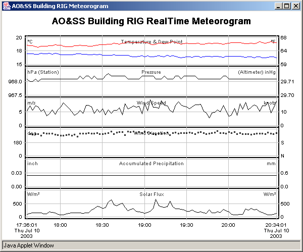 |
This picture of a meteorogram is an example of what you’ll see on the AO&SS Building Rooftop Instrument Group (RIG) Real-time Weather Data Access page. It shows temperature and dew point, pressure, wind speed and direction, accumulated precipitation and solar flux (the amount of sunlight received in a place, varying over time). All the instruments are mounted on a pole on the top of our roof on the University of Wisconsin–Madison campus. |
Petty gives some easy instructions for best use of the page. He, Scott Lindstrom and Chris Schmidt (SSEC) and Peter Pokrandt (AOS) point out some handy on-line tools.
- “Go to the [Web site] and then scroll down to, and click on, the ‘launch meteorogram’ button. … The real-time trends in the meteorological variables are best appreciated by squashing the window horizontally and stretching it out vertically.”
- Also see the latest regional radar loop
- And the corresponding cloud-to-ground lightning map.
- FLI players
- For x-windows, xanim works.
- For windows, get powerflic or waaplay
- Or, if you have had problems with powerflic on Win2k and XP with Netscape 7, Quicktime 5 and higher also handles .fli files.
- If you don’t have an fli player, but support java on your machine, … [SSEC provides] short loops … .
While you’re there, check out all the useful information on SSEC’s Wisconsin and Midwest Weather page.
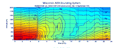
New AERI Page—SSEC’s Atmospheric Emitted Radiance Interferometer has a newly designed Web page, which explains the science behind the instrument and gives examples of the data it collects, such as the atmospheric profile below. On the Data page is information collected in real time at the Department of Energy (DOE) Atmospheric Radiation Measurement (ARM) Southern Great Plains (SGP) sites in Oklahoma where AERI instruments operate automatically.
A Gift of GIFTS—The Geosynchronous Imaging Fourier Transform Spectrometer-Indian Ocean METeorological and OCeanographic Imager GIFTS-IOMI, an advanced atmospheric-measuring instrument concept in development for a planned launch in this decade, now has its own Web site at SSEC. The site explains SSEC’s deep involvement in the project, including instrument and software applications development and processing the voluminous amount of data the instrument will send us.
Missing Astrophysics Found—SSEC has long had an active collaboration with UW–Madison’s Space Physics group, and an astrophysics program of its own led by physicist Wilton Sanders (who also works with Space Physics). An astrophysics page is beginning to form, currently including proposals and other information about the Missing Baryon Explorer, a proposed project studying low energy x-rays to learn more about the structure of the early universe. A previous x-ray astronomy project is the Diffuse X-ray Spectrometer, which flew on Space Shuttle Endeavour in 1993 to learn more about the interstellar medium.
Science Teacher Training—SSEC’s Office of Space Science and Education organizes and gives numerous useful workshops, listed on their Web site. The 24 July GLOBE workshop is noted toward the bottom of OSSE’s front page, with links to workshop information. Applications are still being accepted for both GLOBE and Satellite Meteorology Workshops, both perfect for teachers seeking new ideas for teaching science.
Links to Everything—Well, almost everthing. SSEC’s Media page now sports a page of links to many useful and interesting Web sites, including agencies with whom SSEC often collaborates. Many other links to useful science and technology agency Web sites are also included. Also among the links are general technology and science sites as well as many devoted to the Earth sciences and many devoted to satellites and imagery. Dozens of links are meant for children, but adults will enjoy them, too. This page’s content provider has a special interest in Women in Science, so if you’re interested, too, there are plenty of links. We’ve linked to SSEC stories, as well, but don’t forget to check out the SSEC Media Features page, which lists stories as far back as the 1990s, including our contribution to the Galileo mission to Jupiter. The Media page itself links to our Acronyms list and In the News, which you may also find useful. The Links page features (left-hand bar) a handy email link to use if you find outdated links or have suggested additions.
Always Another Hurricane—It’s true that the page isn’t new, but this is the heart of the Atlantic hurricane season, and where better to track them than at SSEC’s Tropical Cyclones Web site? Even the National Hurricane Center links to this site. SSEC, and its Cooperative Institute for Meteorological Satellite Studies, has been in the hurricane-tracking business using satellite data since the early 1980s. The Web site provides constantly updated imagery and other hurricane news. Click on links in the left-hand navigation bar for weather satellite images and movies.
Antarctica
AMRC Monitors Icebergs—Iceberg C-19 continues to crumble. Shelley Knuth, meteorologist with the Antarctic Meteorological Research Center, informed the National Ice Center that the “AMRC has found that C-19A has broken off three more pieces of ice; two large enough to be called icebergs.” Knuth found evidence of the icebergs breaking in an image from 10 June. An image from 13 June was the earliest image to clearly show the new icebergs. The AMRC has tracked the new crop of large tabular icebergs since they started calving in March 2000. According to Knuth, “The use of satellite data allows the AMRC to frequently observe the position of existing icebergs in and around the Ross Sea, as well as monitor the calving of new icebergs. Without this valuable tool, the icebergs would go unnoticed, potentially causing problems for those who travel [on and] to the continent.” It is the mission of the National Ice Center to announce and name new icebergs.
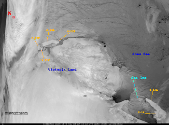 |
All six icebergs can be seen in this infrared image taken on 9 July 2003 by the NOAA-16 polar-orbiting weather satellite. You can also see that sea ice continues to build in the region. |
Pearson Education Australia will use an iceberg image in a new textbook, Longman Geography 10 by Malcolm Stacey et al. From the images that the AMRC has posted since the Ross Ice Shelf starting calving large tabular icebergs, they chose one taken by the NOAA-12 satellite on 9 November 2000.
Antarctic Programs Meeting—In June, the Antarctic Automatic Weather Station (AWS) program, the Antarctic Meteorological Research Center (AMRC), and users and developers of the Antarctic Mesoscale Prediction System (AMPS, not based in Madison) met in Madison to discuss common interests and for status reports on their programs. This year’s meeting was the 21st for the AWS program. AMRC was added in the last 10 years. This year, AMPS, a model designed specifically to forecast weather in Antarctica, was added. About fifty researchers attended from many university and governmental organizations in the United States, England, Australia, and Italy. Bernhard Lettau, program manager for Ocean and Climate in the NSF Office of Polar Programs, attended. Shelley Knuth coordinated the combined workshop; Matthew Lazzara organized AWS and AMRC parts; Jordan G. Powers of the National Center for Atmospheric Research organized the AMPS workshop.
Matthew Lazzara and the AMRC are featured on the Antarctic Kiosk, an informational interactive display at the International Antarctic Center, Christchurch, NZ. Under “Forecasting Now and Then,” the kiosk shows a video of Matthew talking about what the AMRC provides, including data from the Automatic Weather Station program, and why. Christchurch is a jumping-off point for researchers and tourists visiting Antarctica. NASA provided the display.
Data and Imagery
MODIS Gallery—Liam Gumley of SSEC’s MODerate-resolution Imaging Spectroradiometer (MODIS) group has posted some fine MODIS images, some recent ones from NOAA’s National Environmental Satellite, Data, and Information Service with the many from SSEC’s Direct Broadcast Facility. Note the nearly cloud-free images of the southwest U.S. including southern California (7 July) and the U.S.Four Corners area (27 June). Most images on the SSEC MODIS Gallery page are received directly into SSEC’s Direct Broadcast Facility through an X-band antenna on the building’s roof. Those from NOAA and NASA are processed at SSEC.
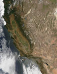 |
This MODIS image of the southwestern U.S. was taken by the NASA Aqua research satellite on 7 July 2003, 2055 UTC and was received at SSEC’s Direct Broadcast Facility. It shows a practically cloud-free southern California.The small image to the left links to a larger one at 1000 meter resolution. One is also available at higher resolution of 250 m. |
Towards Making Satellite Data More Useful More Quickly—On June 5, NOAA and NASA announced their agreement with the National Research Council report, Satellite Observations of the Earth’s Environment: Accelerating the Transition of Research to Operations released this March. They say, “This report is an important step towards reducing the cycle time from research to operations by inserting operational considerations into the early stages of the satellite planning process at NASA.” They also acknowledge that “as leaders in the development and operation of Earth observing satellites, this study is one way the two agencies can administer their responsibilities to the public by designing a more formal bridge between their programs,” and they hope to “involve other agencies in the process to identify a range of civil Earth observation requirements in support of research to operations.”
Webby Awards—NASA’s Earth Observatory Web site received the 2003 Webby Award from the International Academy of the Digital Arts & Sciences. The site received not only a Webby in the Education category, but the People’s Voice Award, determined by popular vote, also in Education. David Herring, Earth Observatory Chief Editor at NASA’s Goddard Space Flight Center, calls the awards “the on-line community’s pinnacle of achievement.” Herring noted that the Academy evaluates Web sites based on content, structure and navigation, visual design, functionality, interactivity, and overall experience. Herring thanked not only the NASA team of writers and researchers, but partners inside and outside NASA, including the University of Wisconsin–Madison. Regular UW–Madison contributors include the developers of the Interactive Composite Editor and SSEC’s MODIS group who regularly supply images from SSEC’s MODIS Direct Broadcast Facility.
SSTs—Java developer Ken Warner of Mammoth Lakes, CA has made a demonstration movie using sea surface temperatures from the SSEC Web site. Warner said of his intent, “It would be fun to watch the ebb and flow of the sea surface temperatures.” You can also see sea ice around Antarctica extend and recede and see temperatures change in the U.S. Great Lakes. Remember, though, the NOAA temperatures we use in our SST browse images are fairly coarse in resolution. Fine analysis is impossible with these. Warner’s “demo,” though, is pretty spiffy. He says of his project: “I have about 15 images on the server. … There is one huge caveat. Performance over a WAN (Wide Area Network) like DSL and/or cable modem speeds is dismal. It takes too long to down load each image and I don’t want to cache the images because of memory constraints. … If the applet and the images are on the same disk on the same machine it really cranks. You can see about 3 to 4 frames a second on a modest machine. My development machine is an 800 mhz P3. …[You] will see that it zooms nicely on large images and has a built-in bilinear anti-aliasing filter that depixelates zoomed images. The images are large and may take a few seconds to load.” Warner is eager to work with other developers. Feel free to contact him.
Planets
In the August 2003 issue of Sky and Telescope magazine, J. Kelly Beatty notes Neptune’s recent change in color, from a mostly overall pale blue towards a whiter, brighter hue. He tells how bands of cloud, particularly in Neptune’s southern hemisphere, have increased from 1996 to 2002, when Lawrence Sromovsky and colleagues at the UW–Madison and NASA’s Jet Propulsion Lab last observed the planet. Other scientists had hypothesized that cosmic ray bombardment was responsible for Neptune’s increased brightening. Sromovsky’s evidence “argues that gradual heating of the upper atmosphere is somehow involved,” indicating that Neptune has seasons.
NASA featured an image of Neptune with a bright southern hemisphere in its Astronomy Picture of the Day on June 13. Managing editor Hugh Westrup will feature “Springtime for Neptune and Uranus” inCurrent Science, a twice-monthly magazine published by Weekly Reader for middle school and high school students.
Software
VisAD Featured—Australia’s Bureau of Meteorology and its use of VisAD are featured in the journal,Software, the official publication of Software Engineering Australia (National) Ltd (S|E|A|). Their work is used prominently on the cover of the June 2003 edition; the article, “High performance computing,” can bedownloaded. In it, Peter Gigliotti of the Bureau, “explains the role of high performance computing and information technology in weather.” Gigliotti is assistant director of Central Operations and Systems at the Commonwealth Bureau of Meteorology in Melbourne. His is an extraordinarily well-written and lucid article that does indeed explain how technology, including software, is used in meteorology today, and how it has improved weather forecasting, especially in Australia’s Bureau of Meteorology.
In the section on software development at the Bureau, Gigliotti explains their use of VisAD, “an open source software suite for the physical sciences,” created by SSEC’s Bill Hibbard and in continual development by software users around the world. The Bureau of Meteorology is using VisAD extensively, Gigliotti noted, in the “development of its next generation of forecaster workstation.” SSEC and its CIMSS has collaborated with the Bureau of Meteorology for many years, on a variety of projects. The article ends with a profile of John Zillman, longest serving director of the Bureau of Meteorology, who has overseen the development of the Bureau’s high-performance computing capability. Zillman leaves his position this year.
Weather Events
Record Hail in Nebraska—Severe convection (thunderstorms) in eastern Nebraska on June 22, 2003 produced record-setting hail (7 inches in diameter) and several tornadoes. Visible imagery from the GOES-12 satellite showed that this convection was initiated along the western edge of a region of stable boundary layer (low-level) wave clouds over southeastern Nebraska. These clouds were remnants of a convective outflow from earlier in the day, a separate stream of dense moist air falling from the bottom of a thunderstorm, like a pancake on a griddle. GOES-12 infrared imagery revealed a classic, long-lived “enhanced-v” signature and cloud top temperatures as cold as -78 C, while infrared imagery from the polar-orbiting NOAA-15 satellite showed cloud tops as cold as -87 C. Scott Bachmeier has posted image examples and animations on the CIMSS GOES Gallery.
Weather Experts
Weather Guys—On their broadcast on 30 June, Steve Ackerman and Jonathan Martin, Weather Guys on Larry Meiller’s WHA Radio call-in show, received a variety of questions related mostly to weather phenomena: What causes summer cloudbursts?—Melted hail figures into the answer. Tornadoes?—They’re thunder storms with strong vertical wind shear that can be tilted to the horizontal and, well, twisted. Amazing things fall out of them, like alligators in 19th century Charleston, SC. Did you know you’re more likely to be killed by lightning than by a tornado? Why does it appear that there are more stars in winter than in summer?—Less water vapor. Winters are getting warmer.—Indicators are lack of snow and less ice on the lakes. What do AOS (meteorology) graduates do?—Broadcast, research/forecast the weather, teach at high school or university, work in private weather companies. What skills do you need?—Math and physics. What kind of summer will we have—After discussing the weather of the past few months, the Guys decided, “We don’t know.” The Weather Guys programs are archived (since February 2002) on Larry Meiller’s Wisconsin Public Radio Web pages. Search on “weather guys.” Generally, you can listen to the Weather Guys, live, on the last Monday of every month.
Weather Research
Snow Albedo Product Validated—J. Box of the Byrd Polar Research Center at Ohio State University compared the albedo values (surface broadband) in the extended Advanced Very High Resolution Radiometer Polar Pathfinder (APP-x) data set to surface-based measurements taken on the Greenland ice sheet. Box found that the mean difference between the satellite-derived and surface-based albedos is near zero with a root-mean-square error of approximately 5%, indicating the high quality of the satellite estimates. The AVHRR-derived snow albedo is a product of the Advanced Satellite Products Team (ASPT) and the Cooperative Institute for Meteorological Satellite Studies (CIMSS).
Global Cloud-type Algorithm Constructed—Michael Pavolonis, a CIMSS researcher, and Andrew Heidinger (NOAA, stationed at SSEC) have developed a way to determine cloud type on a global scale. For their algorithm, they simulated data from the future Visible and Infrared Imaging Radiometer Suite (VIIRS) using MODIS data. Cloud types were determined as in the Clouds from AVHRR (CLAVR) software suite. MODIS data was processed globally for 1 April 2003; the results were consistent with surface-based climatologies. The retrieval of cloud properties is heavily influenced by cloud type, so an accurate determination of cloud type is important. Pavolonis and Heidinger will aim future work at comparing the results of this VIIRS algorithm to the MODIS and VIIRS contractor algorithms.
GOES Sounder Coverage from Japan to Maine—With the Geostationary Operational Environmental Satellite (GOES)-9 positioned over the far Pacific (155 East longitude), CIMSS continues to produce frequent geostationary sounding products, such as total precipitable water, in a wide midlatitude swath across the North Pacific Ocean and the U.S. real-time animations of select GOES Sounder imagery and products provide different perspectives of atmospheric evolution. Cloud top pressure imagery is forthcoming.
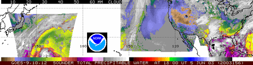
When you click on the small image above, you will find a composite of GOES-9 (far Pacific), GOES-10 (East Pacific and West U.S.), and GOES-12 (East U.S.) Sounder imagery for 1800 UTC on 05 June 2003.
Top: Brightness temperatures derived from GOES Sounder band 11 (7.0 micrometers) show relative moisture patterns in the mid troposphere. Note large, dark, subsiding air masses in the far Pacific (around 25-30N and 155-170E) and East Pacific (around 20-35N and 110-140W) as well as distinctive small-scale closed circulations over central Japan and the northern U.S. plains.
Middle: GOES Sounder band 4 (13.7 micrometers) brightness temperatures show broad large-scale thermal patterns (in clear, cloud-free air) in the mid troposphere. Note the two large longwave ridges, oriented along 160E and 130W.
Bottom: GOES Sounder-derived total precipitable water (the small image, above). Note very moist tropical air (40-55mm) surrounding convection in the Gulf of Mexico with extension of moist air (30mm+) into the south central U.S., very dry air (<10mm) across the interior western U.S., and modest moisture (30mm+) across the mid-Pacific (under the far Pacific ridge and into the mid-Pacific trough).
Antarctica Forecasts—Bob Aune (NOAA, at SSEC) has used MODIS cloud-top pressure and total precipitable water to initialize water vapor and clouds in the CIMSS Regional Assimilation System (CRAS) to model Antarctic weather. Due to MODIS data, significant changes were noted in forecast water vapor, precipitation and cloud fields. Daily forecasts for Antarctica are now being generated in preparation for real-time MODIS assimilation.
Polar Winds for the Navy—The U.S. Navy Fleet Numerical Meteorology and Oceanography Center (FNMOC) has asked CIMSS to provide MODIS polar winds data. Chris Velden and Dave Santek of CIMSS and Jeff Key of NOAA (at SSEC) have set up procedures to routinely transfer the winds data in real time to FNMOC.
Papers, Presentations
Where SSEC staff or students are first through third authors, or, if not, the contributions are substantial.
The Journal of Applied Meteorology has published two papers by SSEC authors in its vol. 42, no. 6, 2003.
- “Mathematical aspects in meteorological processing of infrared spectral measurements from the GOES sounder, part II: Analysis of spatial and temporal continuity of spectral measurements from the GOES-8 sounder” (pages 671-685). Authors are Youri Plokhenko (SSEC/CIMSS), W. Paul Menzel (NOAA, at SSEC), Gail Bayler (SSEC/CIMSS), and Timothy J. Schmit (NOAA, at SSEC).
- “Cloud phase determination using ground-based AERI observations at SHEBA” (pages 701-715), by David Turner, Steven Ackerman, Bryan Baum, Henry Revercomb, and P. Yang.
The Journal of Atmospheric and Oceanic Technology has published “Dry bias and variability in Vaisala RS80-H radiosondes: The ARM experience,” by David Turner (CIMSS), B. M. Lesht, S. A. Clough, J. C. Liljegren, Henry Revercomb (SSEC), and David Tobin (SSEC) in volume 20, number 1, 2003, pages 117-132.
The Journal of Atmospheric and Oceanic Technology has accepted “Detection and analysis of clear sky, low-level atmospheric temperature inversions with MODIS,” by Y. Liu and Jeff Key, for publication. The paper presents a method for estimating low-level atmospheric temperature inversion strength, defined as the temperature difference across the inversion, and height using the Moderate Resolution Imaging Spectroradiometer (MODIS). Inversion strength can be estimated with an uncertainty of 2-3 degrees C; the uncertainty in inversion height is 130-250 m.
The CIMSS Biomass Burning Monitoring Team submitted abstracts to the American Meteorological Society’s (AMS) 5th Symposium on Fire and Forest Meteorology Joint with the 2nd International Wildland Fire Ecology and Fire Management Congress, to be held November 16-20, 2003 in Orlando, Florida. The abstracts cover recent validation efforts and improvements in product speed for the GOES Wildfire Automated Biomass Burning Algorithm (WF_ABBA). “Recent validation studies of the GOES Wildfire Automated Biomass Burning Algorithm (WF_ABBA) in North and South America” was submitted by Joleen Feltz (CIMSS), Michel Moreau (Environment Canada/Meteorological Services/Quebec region), Elaine M. Prins (NOAA), Kirsten McClaid-Cook (State University of New York-Albany), and Irving F. Brown (Woods Hole Research Center/Federal University of Acre, Brazil). “GOES Wildfire ABBA Applications in the Western Hemisphere” was submitted by Christopher C. Schmidt (CIMSS) and Elaine M. Prins.
Education, Outreach
SHARP at SSEC—This summer, SSEC is hosting three high school students in NASA’s Summer High School Apprenticeship Research Program (SHARP). Ashley Minor is assisting Jim Kossin with hurricane research, William Salinger is working with Sanjay Limaye on a proposed Venus mission, and Charles Rivenbak is working with Larry Sromovsky in research into atmospheres of the outer planets. Limaye also directs SSEC’s Office of Space Science Education. NASA SHARP is designed to foster and increase the involvement of high school students in science, mathematics, technology, engineering and geography. The program is especially designed to focus on students from groups traditionally underrepresented in those fields, both academically and in the workplace.
On Friday, June 27, 2003, 21 students participating in SHARP at UW–Madison visited SSEC for a building tour. Also, Gary Wade (NOAA, at SSEC) and Ana Picon gave presentations, promoting the NOAA presence at UW. Wade showed real-time satellite data and CIMSS products. Picon told the students about NOAA’s recently established Cooperative Remote Sensing Science and Technology Center (CREST) in Puerto Rico, where she is a graduate student. Picon is visiting CIMSS this summer to compare cloud height retrievals from different satellite sensors.
Honors
Aqua Award—SSEC scientists have received NASA’s Group Achievement Award for their work on the mission to launch the Aqua satellite. The Goddard Space Flight Center presented the award to SSEC scientists for “Outstanding Teamwork” toward the success of the Earth Observing System Aqua Mission Team. Aqua was launched 16 May 2003. Award recipients are Hank Revercomb (SSEC director), Steve Ackerman (director, CIMSS), Dave Tobin (SSEC researcher), and Paul Menzel (NOAA Chief Scientist, at SSEC). The researchers contributed expertise toward the satellite’s MODIS and AIRS instruments and will receive an attractive certificate and metal medallion.
Unidata Committee—Tom Whittaker, CIMSS software programmer, has been asked to serve on the Steering Committee for Unidata’s Integrated Data Viewer (IDV) to help guide its future development. The IDV is a new display and analysis tool based on VisAD, for 2D/3D visualization and next-generation, collaborative data analysis. Unidata is a program operated by the University Corporation for Atmospheric Research and sponsored by the National Science Foundation that enables universities to acquire and use meteorological and other data in teaching and research. SSEC, and Whittaker, have been involved in Unidata since the planning stages in the early 1980s.
Incidentally, Whittaker’s picture is one of four at the top of the NOAATech 2004 page, right over Agenda. The NOAATech Workshop serves “as a showcase for NOAA’s achievements in high-end computing, network and web technologies.” Whittaker, who designs creative Java applets for Earth science—you’ve read about them often in In the News, is a worthy representative.
NOAA Great Lakes Area Coordination—As part of NOAA Administrator Vadm. C. Lautenbacher’s plan for pilot programs on NOAA regionalization, Steve Brandt of the Great Lakes Environmental Research Laboratory (GLERL, Ann Arbor, Michigan) will lead a committee to coordinate NOAA activities in the Great Lakes region. Each NOAA line office is represented on the committee, including the Advanced Satellite Products Branch, the NOAA group at SSEC. Jeff Key, team leader of the ASPB, will represent the National Environmental Satellite, Data, and Information Service, the ASPB’s parent group within NOAA. The two main goals of the regional committees are to improve intra-line office communication and to develop and enhance NOAA’s image in the region.
In the Wings
Physics of Star Trek Author at Space Place—SSEC is pleased to announce that Lawrence M. Krauss, author of Physics of Star Trek and other generally understandable science books, will give a public lecture at UW Space Place on August 12. Professor Lawrence M. Krauss is an internationally known theoretical physicist with wide research interests, including the interface between elementary particle physics and cosmology. His studies include the early universe, the nature of dark matter, general relativity and neutrino astrophysics. He has written more than 200 scientific publications and numerous articles and books for the nonscientist. Space Place, located at 1605 South Park Street in Madison, regularly hosts free lectures on the second Tuesday of each month at 7 p.m. The visit is organized by Sanjay Limaye, director of SSEC’s Office of Space Science Education.
Thanks to Tim Schmit, Gary Wade and Don Wylie for help with meteorological terms; to Bill Bellon and Brian Kayon for screen shots and other technical assistance; to Rose Pertzborn, Leeanne Avila, Jean Phillips, and Jeff Key; and to all the content providers in the top story on SSEC’s Web sites.