Monthly News Summary – November 2002
Antarctica
by Terri Gregory, SSEC Public Information Coordinator
This month’s column includes news coverage and research current in October, future events. Use images freely with credit to the Space Science and Engineering Center, University of Wisconsin–Madison.
The Office of Legislative and Public Affairs in the National Science Foundation has published its 2002Polar Press Clips. The Antarctic Meteorological Research Center (SSEC) and the Automatic Weather Stations program (SSEC and the Department of Atmospheric and Oceanic Sciences) were included in three press clippings and in three NSF news releases. Most coverage regarded monitoring calving and progress of monster icebergs in the Ross Sea. The Press Clips offers a selection of the many times NSF-funded research is covered throughout the year. The AWS and AMRC are two of many research programs supported by NSF. Also see Neutrino News.
Kristan Hutchinson interviewed Linda Keller for the Antarctic Sun, the newspaper for and by Antarctic researchers. Keller, of the Department of Atmospheric and Oceanic Sciences, works in SSEC’s Antarctic Meteorological Research Center and provided answers about the center’s role in monitoring icebergs.
WORT-FM, public access radio station broadcasting from Madison, Wisconsin, will do a long-range remote when it features Matthew Lazzara on its January 30 science show, broadcast on alternate Thursday evenings at 7:30 p.m. Lazzara will call Dennis Shaffer, host of WORT’s “Making Contact,” from McMurdo Station in Antarctica. The time “on the ice” will be about 2:30 p.m., January 31.
Nancy Odalen, now an administrator with SSEC’s Antarctic Astronomy and Astrophysics Research Institute (A3RI), appeared on Nathan Sandwick’s radio call-in show on WSUM, the UW–Madison student radio station, to talk about Antarctica. Odalen worked for the Center for Astrophysical Research in Antarctica (CARA) before joining A3RI. As Director of Finance for CARA she visited the Amundsen-Scott South Pole Station three times since 1995. Her last visit was in January 2002.
Data and Imagery
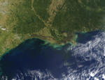
The MODIS instrument on board NASA’s Terra satellite captured the Mississippi River Delta on a clear day in October, via direct broadcast at SSEC. You can see New Orleans to the south of Lake Ponchartrain and the bridge across the lake as well as the delta itself and the muddy water in Chandeleur and Breton sounds, east of New Orleans and north of the delta.
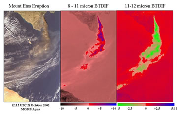
The eruption of Italy’s Mt. Etna was captured by MODIS on October 28. Kathy Strabala of SSEC’s MODIS team, who specialize in cloud characteristics, brought in the data from NASA to analyze the ash plume. The brightness temperature differences (BTD) found in the Etna plume were positive, rather than negative as had been found in other volcanic eruptions, suggesting the presence of ice in the plume. Scientists will continue to analyze volcanic eruptions whenever Terra flies over an erupting volcano.
McIDAS users meet—Users of SSEC’s Man computer Interactive Data Access System, McIDAS, met at UW–Madison in October. Researchers and developers from around the world discussed their special uses of and requirements for the system, in use by meteorological agencies since the early 1970s.
James Kelly of the Meteorological Systems Section in Australia’s Bureau of Meteorology Research Centre showed how more than two dozen sites, in Australia, Fiji, and Malaysia, and the Australian Navy use satellite data to forecast the area’s unique weather. Marine weather forecasting is a special concern for the country, surrounded as it is by ocean.
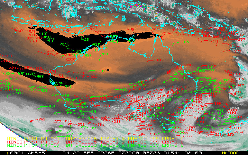 |
This geostationary weather satellite image of Australia and the ocean around it shows wind measurements at various levels in the atmosphere. |
Matthew Lazzara, of SSEC’s Antarctic Meteorological Research Center, told how he uses McIDAS to produce composites of Antarctic weather from a variety of satellite data, under the sponsorship of the National Science Foundation. The AMRC also produces other products, such as meteorograms, using McIDAS.
Fred Mosher, of the National Weather Service’s Aviation Weather Center, demonstrated problems in compositing, or combining, satellite images over large areas, such as oceans.
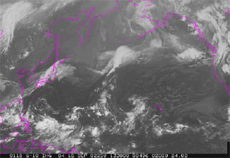 |
A composite of two geostationary weather satellite images using the minimum brightness of the two images. This eliminates colder (limb darkening) elements near the edge of the earth. This technique also requires both satellites to show the cloud in the same location |
Marianne König of Eumetsat introduced the group to the new geostationary satellite, Meteosat Second Generation (MSG). The MSG’s main instrument, a radiometer, has more channels than previously, and takes images at higher resolution and more often. The new satellite gives Europe and Africa improved Nowcasting (current forecasts), better identification of low clouds and fog, more precise sea surface temperatures, higher data-collection capacity for climate monitoring and other science, and even a search and rescue package for emergencies.
NASA’s Langley Research Center uses McIDAS and satellite imagery to help calibrate satellite instruments they develop. They also use McIDAS in a variety of atmospheric research including contrail and cloud property investigations.
NOAA’s Satellite Analysis Branch (SAB) has used McIDAS since the VAS Data Utilization System was installed in the 1980s. According to Tom Renkevens, the SAB provides “high quality, real-time global satellite-derived products, interpretive analyses, and other information,” which “support domestic and international meteorological warnings and forecasts, numerical weather models, climate analyses and other initiatives” within the Federal government. McIDAS enables them to provide satellite imagery and products through the National Weather Service and the Web to the general public.
Tom Yoksas told how Unidata has progressed from its grassroots beginnings in 1983 to a nationwide network of users in more than 160 departments and research organizations in North American universities. Data products and software are delivered primarily over the Internet now. The NSF continues to fund Unidata development.
Neutrino News
AMANDA and IceCube, SSEC’s two neutrino telescope projects at the South Pole, are included in the NSF 2002 Polar Press Clips (see Antarctica). Both the Milwaukee Journal Sentinel and Wired magazine featured the unusual neutrino telescopes embedded in the south polar ice.
Tropical Cyclones
The American Geophysical Union announces Volume 55 in its Special Publications Series, Hurricane! Coping With Disaster, edited by Robert Simpson, Richard Anthes, Michael Garstang and Joanne Simpson. The book is hot off the presses the first week of November. Chris Velden, Joanne Simpson, W. Timothy Liu, Jeff Hawkins, Kurt Brueske, and Richard Anthes wrote chapter 11, “The Burgeoning Role of Weather Satellites.” The book can be ordered on the AGU Web site.
Wisconsin Week, October 9, featured SSEC’s hurricane research and monitoring activities. SSEC’s Liam Gumley provided the MODIS image of Tropical Storm Isidore. The CIMSS Tropical Cyclones group shares techniques and satellite imagery with the National Hurricane Center throughout the year, but especially during hurricane season, which officially ends on December 1. According to researchers at the Tropical Prediction Center, “the latest observed hurricane was on December 31, 1954, the second ‘Alice’ of that year which persisted as a hurricane until January 5, 1955. . . . The latest hurricane to strike the United States was late on November 30, 1925 near Tampa, Florida.”
Star Trek: Enterprise, the TV show, will use hurricane imagery as a basis to construct storms for other solar systems in galaxies far, far away. Computer artist Jim Van Over said that a future script “calls for a satellite view of a storm crossing the surface of a planet.” Tim Olander, of the Tropical Cyclones group, sent Van Over a series of storm movies made over the years. Star Trek’s storm will be loosely based on an amalgam of several and will not be recognizable, Van Over said.
During hurricane season, the Tropical Cyclones group hears from a great many people who depend on their Web site. Rebecca Lear of the Office of Beach Management for the City of Virginia Beach, Virginia noted that “it’s a matter of when and not if a major storm impacts our area and it’s folks like you that give us our heads up.” The Tropical Cyclones Web site experienced half a million hits on Wednesday, October 2 from folks like Rebecca.
Weather Experts
SSEC researcher Don Wylie talked about El Niño with a WNWC Radio (Madison, Wisconsin) news reporter on October 4. They focused on the effects this El Niño might have on Wisconsin weather. Mostly, this winter will be almost as cold as is normal in Wisconsin.
Weather Guys Steve Ackerman (CIMSS and AOS) and Jonathan Martin (AOS) appeared on Larry Meiller’s WHA Radio call-in show on Monday, October 28. Their devoted and eclectic radio audience asked about a variety of issues. The Guys are next on WHA on November 25, the last Monday of the month. Listen in from 11:45 to 12:30 central time. In south and central Wisconsin, you can listen at 970 AM and 90.7 FM, or listen from anywhere on the Web.
Weather Research
Better rain forecasts—Experiments with the Cooperative Institute for Meteorological Studies (CIMSS) Regional Assimilation System (CRAS), a weather forecast model that uses satellite data in its calculations, show a more accurate precipitation forecast when GOES water vapor and cloud top pressure are included over water as well as land. The Eta Data Assimilation System (EDAS), used by the National Centers for Environmental Prediction to forecast U.S. weather, does not use GOES water vapor or cloud information over the Gulf of Mexico, and failed to show rain that fell over Tennessee and Kentucky from Tropical Storm Isidore when it moved ashore. The CRAS forecast was more in line with what River Forecast Center rain gauges actually measured.
Dave Santek and Chris Velden (CIMSS) and Jeff Key (NOAA team leader at SSEC) are now producing information on winds around the poles in nearly real time. The Goddard Institute for Space Studies sends data from the Moderate Resolution Imaging Spectroradiometer (MODIS) instrument on the Terra satellite from a computer in the Office of Satellite Data Processing and Distribution via the Internet to CIMSS, where software automatically estimates wind speed, direction and height for both polar regions. According to Santek, wind information is made available to the scientific community “as soon as the data are available, about 2–4 hours after acquisition. For global data from a polar satellite, that’s pretty quick!”
Papers—“Validation of TOVS Path-P data during SHEBA” was published in theJournal of Geophysical Research (107(C10), 8041, doi:10.1029/2000JC000453). The authors are A. Schweiger and R. Lindsay (University of Washington), J. Francis (Rutgers), J. Key (NOAA, at SSEC), J. Intrieri (NOAA), and M. Shupe (Science and Technology Corporation). The paper evaluates the accuracy of sounding and cloud retrievals using the TIROS Operational Vertical Sounder in the context of measurements made during the year-long Surface HEat Budget of the Arctic (SHEBA) field experiment.
“Antarctic cloud radiative forcing at the surface estimated from the AVHRR Polar Pathfinder and ISCCP D1 data sets, 1985–1993,” by Michael Pavolonis (CIMSS) and Jeff Key (NOAA), was accepted by the Journal of Applied Meteorology for publication in a future issue. The paper describes the radiative effect of clouds on the surface of Antarctica as determined from two satellite data sets. The authors showed that on a monthly time scale, clouds over the interior of the continent warm the surface at all times of the year.
CIMSS, NOAA and SSEC scientists will present several papers at the 2003 AMS Annual Meeting in Long Beach, California, in February 2003. Among them are these to be given at the 12th Conference on Satellite Meteorology and Oceanography.
- “Channel Selection For The Next Generation Geostationary Advanced Baseline Imagers,” by T. Schmit and W.P. Menzel (NOAA, stationed at SSEC), J. Sieglaff and J. Nelson (CIMSS), and M. Griffin (MIT)
- “First satellite intercalibration comparing high spectral resolution AIRS with operational geostationary imagers,” by Mat Gunshor and Dave Tobin (CIMSS) and Tim Schmit and Paul Menzel (NOAA)
- “Surface and Atmospheric Retrievals from the Future GOES Sounder – Advanced Baseline Sounder (ABS),” by Jun Li (CIMSS), Tim Schmit (NOAA), Fengying Sun (CIMSS), and Paul Menzel (NOAA)
- “Recent Arctic Climate Trends Observed from Space, 1982-1999,” by X. Wang and Jeff Key (NOAA)
- “A Two-year Analysis of Fire Activity in the Western Hemisphere as Observed with the GOES Wildfire Automated Biomass Burning Algorithm,” by Elaine Prins (NOAA) and Chris Schmidt and Joleen Feltz (CIMSS), and collaborators at the Naval Research Laboratory in Monterey, California (J. Reid, D. Westphal, and K. Richardson), provides an overview of fire statistics for the Western Hemisphere derived from two years of half-hourly GOES-8 imagery and examples of real-time assimilation of the GOES Wildfire Automated Biomass Burning Algorithm (ABBA) into the Naval Aerosol Analysis and Prediction System.
- “GOES-11 and GOES-8 Sounders During the International H2O Project (IHOP)-2002 Field Experiment,” by Gary Wade and Tim Schmit (NOAA) and Wayne Feltz, Jim Nelson, and Tony Schreiner (CIMSS), provides a discussion of Derived Product Imagery (DPI) from the GOES-8 and -11 Sounders during IHOP.
- “Real-time derivation of cloud drift and water vapor winds in the polar regions from MODIS data,” by Dave Santek (SSEC & CIMSS), Jeff Key (NOAA), and Chris Velden (CIMSS), gives a status report and some results for the derivation of high-latitude winds from the MODIS instrument.
- “Relationship between satellite derived cloud parameters and ground based measurements of solar ultraviolet radiance,” by A. Heidinger (CIMSS) and M. Uddstrom, uses the cloud properties from the Clouds from AVHRR (CLAVR) algorithm that is currently being transitioned to operations.
Several SSEC and CIMSS scientists delivered papers at the Society of Photo-optical Instrumentation Engineers meeting held in Hangzhou, China in late October. Some of them are:
- “Advanced Baseline Imager (ABI) for future Geostationary Operational Environmental Satellites (GOES-R and beyond),” by Tim Schmit (NOAA), Jun Li (CIMSS), and W. Paul Menzel (NOAA)
- “Advanced Baseline Sounder (ABS) for future Geostationary Operational Environmental Satellites (GOES-R and beyond),” by Jun Li, Tim Schmit, and Paul Menzel
- “Arctic climate characteristics and recent trends revealed by the AVHRR Polar Pathfinder data set,” by X. Wang, Jeff Key (NOAA), and Michael Pavolonis (CIMSS)
Education, Outreach
VISITView success—For some time, the interactive software training package, VISITView, has been used by forecasters in the National Weather Service to develop their ability to use satellite imagery in weather forecasts. More recently, this interactive package has been used in teletraining sessions that link researchers all over the world in real time. Patrick Dills, of the Cooperative Program for Operational Meteorology Education and Training, a program of NOAA and the University Corporation for Atmospheric Research, wrote in glowing terms of a recent session to Tom Whittaker, SSEC’s developer of the VISITView software package.
Dills linked sites in Melbourne, Australia; Hanoi, Vietnam; and Guam all using VISITView and a mix of Internet Audio and conference calls. Unknown to Dills, Melbourne’s Bureau of Meteorology was hosting its own tropical cyclone workshop for World Meteorological Organization forecasters and meteorologists across the Pacific and Indian Oceans. That workshop alone was “running on a dozen or so workstations,” said Dills, so he moderated at least 15 connections at one time.
In this complicated interactive milieu, Dills said, “VISITView performed flawlessly. Monitoring the command responses for each site showed a typical response time to instructor slide changes, annotations, etc., under 2 seconds.” Dills gave credit to Tony Mostek of the VISIT team for refining logistics for the entire process, from scheduling, to notification, and follow up and noted that “it could not have happened without VISITView and all of your [Tom Whittaker’s] development efforts.” He added that he could think of nothing to improve.
A new center at UW–Madison will help researchers develop teaching skills. The National Science Foundation has funded the Center for the Integration of Research, Teaching and Learning to “teach science effectively to ever-widening audiences,” according to Terry Devitt in Wisconsin Week, October 23. Principal investigator and astronomer Robert Mathieu hopes the new center will help students become scientifically literate and “promote a public better prepared to live in a high-tech world.” In the new science teaching center Steve Ackerman and Sharon Dunwoody will teach a course to graduate students. Ackerman directs SSEC’s Cooperative Institute for Meteorological Satellite Studies and teaches in the Department of Atmospheric and Oceanic Sciences; Dunwoody, a journalism professor, directs the School of Journalism and Mass Communication and the school’s science writers’ program. Ackerman believes that their course will be “beneficial to graduate students, because more and more scientists will be talking to the public, and this can only improve their teaching, because teaching is communicating.” Ackerman added that students will be required to produce an outreach activity of some sort. CIRTL resides in the Wisconsin Center for Educational Research.
A new Web site, “K–12 at UW–Madison,” includes SSEC’s Office of Space Science Education (OSSE) and CIMSS outreach in its resource base. Terrence Millar, Graduate School associate dean, helped develop the site with area teachers and university personnel and noted that the university’s resources “could be useful to K–12 teachers and classrooms if made available in an accessible way.” The site includes more than 150 separate entries, a distillation of many difficult-to-find resources scattered across the University of Wisconsin–Madison. More are expected to be added as they are found.
Honors, Awards
Shaima Nasiri’s grant to work with NASA’s Earth Observing group at Goddard Space Flight center was noted in “Grants, Fellowships” in Wisconsin Week, October 23. Nasiri received the first Suomi-Simpson Graduate Fellowship sponsored by NASA and CIMSS.
Errata
Reader Matthew Lazzara noted an errant headline in the Bulletin of the American Meteorological Society (August 2002) that caused him to write a letter to the editor. The headline in “Nowcast” implied that methane (from cattle) was causally connected to the ozone layer. It’s not. Lazzara’s correction appeared in the September BAMS. He manages SSEC’s Antarctic Meteorological Research Center.