Improvements in Tropical Cyclone Forecasting
This July, the National Oceanic and Atmospheric Administration (NOAA) implemented routine use of the newest version of a formula, or algorithm, known as the Advanced Dvorak Technique (ADT). Under development by researchers at the Cooperative Institute for Meteorological Satellite Studies (CIMSS) since the late 1990s, the algorithm utilizes infrared imagery obtained from geostationary satellites to measure tropical cyclone intensity through its lifecycle — from the earliest stages of formation through dissipation.
According to Chris Velden, lead scientist of the ADT algorithm, this newest release has resulted in more “consistent and statistically accurate measures of hurricane intensity,” critical information for forecasters around the world who monitor hurricane formation and development and issue warnings to the public.
The most significant improvement to the ADT is the incorporation of microwave data directly into the infrared-based intensity estimates. In previous versions, CIMSS scientists transmitted the microwave information to NOAA in a process separate from the algorithm module itself – now, the data acquisition and the application module are combined. The net result is that intensity estimates can be immediately compared with microwave information yielding better estimates of hurricane eye and cloud region temperatures, maximum wind speeds and eye score values.
-
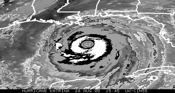
Infrared satellite image of Hurricane Katrina (2005) using the Basic Dvorak Hurricane
Enhancement Curve for Tropical Cyclone Classification, or “BD Curve.” The black/white/gray ranges represent different intensity classifications in the Subjective Dvorak Intensity Classification Technique. Credit: Tim Olander.
The ADT algorithm package has officially transitioned from the CIMSS research environment to NOAA operations. This is an important step because ADT estimates are developed for all active tropical cyclones anywhere on Earth. Primary users of the ADT are the National Hurricane Center, the Central Pacific Hurricane Center and the Joint Typhoon Warning Center, but Velden points out that any tropical cyclone operational center can access the data with an Internet global data access feed.
While this new version of the ADT is a significant improvement, continued feedback on the algorithm’s performance from its users is critical. Velden’s team relies on this feedback so that future versions, already underway, can be enhanced based on specific user observations and needs.
The ADT program at CIMSS is supported by funding from the Office of Naval Research (ONR), NOAA’s GOES Improved Measurements and Products Activities Plan (GIMPAP) and NOAA’s Product System Development and Implementation (PSDI).
For more information, contact Chris Velden or Tim Olander.
By Jean Phillips