Monthly News Summary – September 2002
Satellite Data for Aviation Weather
by Terri Gregory, SSEC Public Information Coordinator
John Murray, atmosphere scientist at NASA’s Langley Research Center, features the work of CIMSS and other SSEC projects in Earth Observation Magazine for August. In “Aviation Weather Applications for Earth Science Enterprise Data,” Murray reviews the current state of what he calls the U.S. “national airspace system,” focusing on weather-related issues. He notes that, “Over the short term, the impact of weather on aviation can be lessened substantially if satellite weather information is employed more effectively.” He goes on to stress that it will be important in the long-term to “integrate new high-spatial- and temporal-resolution satellite weather observations … .” Some of these, he says, will be taken by NASA’s planned Geosynchronous Imaging Fourier Transform Spectrometer (GIFTS). Murray says that satellite observations are underutilized in forecasting aviation weather, primarily, he says, “because of the low vertical resolution of satellite soundings.” He notes that GIFTS will “improve the vertical resolution of GOES by a factor of six, or from 18,000 feet to 3000 feet,” meaning it can sense something every 3000 feet, a phenomenal increase in remote sensing ability. GIFTS will also “increase the number of soundings [vertical observations] by several orders of magnitude,” and “is expected to retrieve more than 100,000 high-vertical-resolution soundings per minute.” SSEC is a partner with NASA Langley Research Center and other institutions in GIFTS development and is chiefly responsible for making GIFTS data useful.
Besides NASA’s Aviation Safety Program at Langley, which is helping the FAA to develop useful satellite products, SSEC’s CIMSS is studying the impact of using GOES satellite data for aviation forecasting. Thus far, it appears that satellite data will improve FAA forecasts of convection (local severe storms), turbulence, icing, visibility and ceiling conditions. Murray notes that CIMSS will also study the impact of data from high-resolution instruments such as the Atmospheric InfraRed Sounder launched this spring on NASA’s Aqua satellite and later, the GIFTS. Of particular use to pilots will be “very-high-resolution wind fields.” Instead of using winds tracked from clouds, a product that SSEC and its CIMSS has a long history of producing, Murray notes that wind measurements will be derived from “water vapor flux tools” that will “greatly improve many FAA products.” Murray views the future of aviation weather forecasting optimistically, noting the current U.S. administration’s seeming commitment to “requirements for precise, widespread environmental knowledge.” Murray believes that “these systems and applications will generate accurate aviation weather information that ultimately will be integrated into an automated, worldwide air transportation information network.”
In the same issue of EOM is “A Change in the Weather: How NASA Is Leading a Revolution in Weather Measurements.” Written by Stephen Sandford and William Smith, the article explains GIFTS, its capabilities and history, in lucid detail. The authors note that the architecture employed in GIFTS enables a great “increase in the number of places … where weather measurements are made and also provides the measurements much more often.” More measurements mean that forecasting models will be able to better “simulate the real atmosphere and its dynamic variations, thereby increasing dramatically the reliability of weather forecasts.” Currently, GIFTS is expected to launch late in 2005. Sandford directs LaRC’s Earth and Space Science program. Smith is LaRC’s chief scientist of Atmospheric Sciences Competency and is principal investigator for the GIFTS-Indian Ocean Meteorological and oceanographic Imager project. Smith also led SSEC’s CIMSS and taught in the Department of Atmospheric and Oceanic Sciences (AOS) at UW–Madison from 1981–1997.
Antarctica
Antarctic programs featured—Matthew Lazzara appeared on WORT-FM radio’s Thursday evening science show on August 29. He and host Dennis Shaffer discussed Antarctic research and the Automatic Weather Station program, which supplies weather data to researchers and anyone else interested in the continent.
Wisconsin Names—A specialized map of Antarctica appears in Wisconsin Research—Profiles in Discovery, 2002-2003, published by UW–Madison’s Communications office. The booklet samples research performed in the Graduate School’s research groups. The map lists only features with a connection to Wisconsin. Because so many Antarctic pioneers came from UW–Madison, there are many of them. The map lists only a few, led by the Wisconsin Islands, off the tip of the Antarctic Peninsula. Names with a connection to SSEC and the Department of Atmospheric and Oceanic Sciences (AOS) include the Bentley Subglacial Trench and Mount Stearns. Charles Bentley, emeritus professor in the Department of Geology and Geophysics, is principal investigator for SSEC’s Ice Coring and Drilling Services. Charles Stearns, emeritus professor in AOS, leads the SSEC/AOS Automatic Weather Station program and SSEC’s Antarctic Meteorological Research Center. AMANDA, at the South Pole, is also shown on the map. See Neutrino News.
Data and Imagery
GOES Gallery—Markus Pahlow, a Ph.D. student at Johns Hopkins University, plans to use MODIS and GOES images from the Gallery in his thesis based on a haze event resulting from this summer’s forest fires in Quebec. When seeking to learn more about the cause of the fires, he searched the Web and found the GOES Gallery, noting, “The images are very impressive.” He believes they will “make it easier to explain how it started.” CIMSS and SSEC are pleased when GOES Gallery images are used to illustrate a paper or report. As Pahlow is doing, please give us credit and let us know when and where you’re using them.
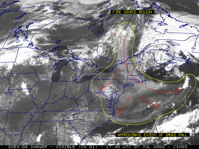 |
This GOES image shows the extent of smoke from fires in Quebec in July 2002. |
Black Water—In this image, received at SSEC’s direct broadcast facility, MODIS manager Liam Gumley uses three channels to produce a close-to-true-color image. The image of dark water off Florida’s Gulf coast was received on August 14, 2002 and was used on NASA’s Earth Observatory. Ocean researchers are analyzing the water.
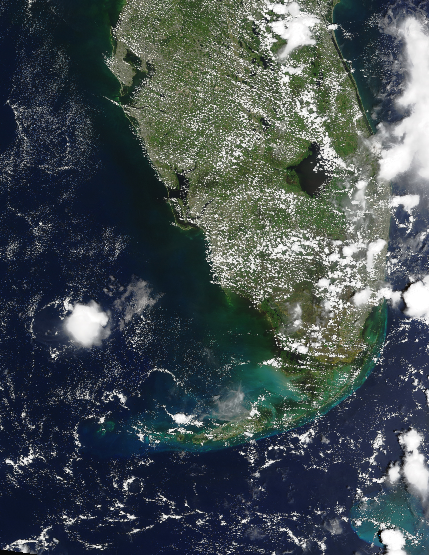 |
This MODIS image of Florida shows unusually dark water off the Gulf coast. |
Delta—Minnesota’s Itasca State Park used a MODIS image from SSEC’s direct broadcast facility in the new Jacob V. Brower Visitor Center. The Minnesota DNR used the 3-color composite MODIS image of the Mississippi River Delta in a display about the Mississippi River, crediting Liam Gumley of SSEC’s MODIS team as well as SSEC and UW-Madison.
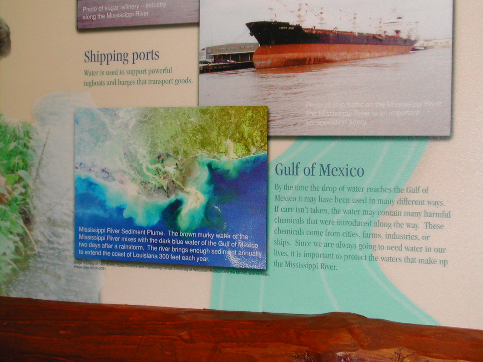 |
MODIS image of the Missippi River delta. This picture was snapped by a visitor to the display who photographed it on the wall, so it is somewhat distorted.This image shows the delta on April 24, 2001, a different time from the image at the left, and of very high resolution. |
Neutrino News
Francis Halzen’s captivating and informative article, “Looking for Tiny Messengers,” appears in Wisconsin Research, the new publication on research conducted in Graduate School centers. Halzen, a Distinguished Professor of Physics, tells the story of his search for neutrinos, tiny subatomic particles that exist but are extremely hard to find, although, as Halzen says, “a million billion” zip through the Earth and our bodies every second. His project AMANDA is devoted to that task. Halzen explains how he got the idea to put detectors in South Polar ice to capture the illusive particles and how it is necessary to carve out even a greater chunk of ice for a kilometer-cube-sized polar observatory, or IceCube. Francis Halzen is IceCube principal investigator.
Looking Back?—“Looking Back at the First Decade of 21st-Century High-Energy Physics” by CERN theoretical physicist John Ellis features IceCube. Ellis writes from the perspective of a presenter at the Tenth Conference on String Phenomenology in 2011. Probably physicists will understand the “developments” Ellis recounts, but anyone with a smattering of science in their background will know it’s funny. They just might not know why. Ellis starts with the premise that the Large Hadron Collider is built and responsible for scores of discoveries, including a black hole event. [Readers of this column may remember that data from the SSEC instrument, the High Speed Photometer, showed evidence of a black hole in 2001.] In Ellis’ version of 21st century physics, physicists are “all on tenterhooks to see whether some supersymmetric interpretation of the IceCube dark-matter signal will be confirmed.” He references Web sites for many projects that exist now, in 2002, including the IceCube Web site.
NOAA Uses GOES Fire Products
WF-ABBA Used at NOAA—Elaine Prins (NOAA, at SSEC) and Chris Schmidt (SSEC’s CIMSS) have installed and tested an updated version of the GOES Wildfire Automated Biomass Burning Algorithm (WF-ABBA, version 6.0) system in NOAA’s Office of Satellite Data Processing and Distribution’s Satellite Services Division. They also delivered required documentation in the final step to being considered fully operational by NOAA’s National Environmental Satellite, Data, and Information Service. The technique has been used routinely this summer in helping track wildfires throughout the western U.S.
Modeling Pollution—GOES wildfire products are being used in South America to study how air pollution disperses in the atmosphere. The WF-ABBA gives information every half-hour on fire location, size and temperature. Saulo Freitas and Karla Longo (University of Sao Paulo, Brazil) are assimilating these products into the Regional Atmospheric Modeling System (RAMS at Colorado State University) in real time to diagnose the transport of biomass-burning emissions of carbon monoxide and aerosol particles smaller than 2.5 microns. This collaborative effort extends work that began with a simulation study utilizing the South American ABBA fire product for the 1999 fire season. Thus far, the model output agrees well with data from the Total Ozone Mapping Spectrometer and with ground truth data. At CIMSS, the biomass-burning algorithm is developed by Elaine Prins (NOAA) and Chris Schmidt and Joleen Feltz (CIMSS).
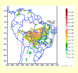 |
An example of the University of Sao Paulo’s biomass burning emissions model output for August 13, 2002. The GOES WF-ABBA fire product is used to determine the fire point sources and relative fire size and temperature. Emissions are based on the WF_ABBA fire product and then used to diagnose the transport of carbon monoxide and small particles at various levels in the atmosphere. |
NOAA Magazine featured the WildFire ABBA as used in NOAA’s Fire Weather Services. It notes that “weather is one of the most significant factors” influencing the behavior of fires and calls the WF-ABBA “the latest and most advanced development in NOAA’s fire detection from space.” The article notes that the technique takes advantage of geostationary orbit’s “constant watch over specific fires.” The automated technique supplies fire products every half-hour over the entire Western Hemisphere.
Tropical Cyclones
Pacific Hurricanes—Outdoors enthusiast David Voth of San Diego, California, told us he uses the Tropical Cyclone site every day during the Northeastern Pacific hurricane season. He said, “I haven’t found a better source for information on tropical weather that sometimes affects my area, and I have learned a great deal by exploring the links you provide. … I find that keeping up with the tropical cyclones extends my understanding of the southern swells and monsoons.”
Weather Experts
Is It Back?—On August 7, University Communications announced to the media that “El Niño is back,” and enlisted scientists from SSEC and the Department of Atmospheric and Oceanic Sciences (AOS) to talk about it with the media. Ed Hopkins (a lecturer in AOS) and Dave Martin (SSEC scientist) were interviewed on a warm Saturday afternoon. WISC-TV, Madison’s channel 3, ran a short piece on the evening news. In a longer piece at 10 p.m., Dave Martin and Ed Hopkins explained that, while it might be unusual to have two El Niños in five years, it remained to be seen what effect this El Niño would have on worldwide weather. Martin was also interviewed for news programs on WKOW TV channel 27 and Wisconsin Radio Network. SSEC scientist Don Wylie was interviewed for Wisconsin Public Radio by Larry Meiller and appeared on WIBA Radio, noting that a relatively warm winter was likely. All Wisconsin interviewers asked about the impact of the current El Niño on Wisconsin’s upcoming winter.
Martin and CIMSS scientist Bill Raymond provided information to Ana Fernandes of the Portuguese daily newspaper, Publico. She and other European writers want to know if El Niño could be responsible for this summer’s floods. The scientists think not.
Weather Guys—Professors Jonathan Martin (AOS) and Steve Ackerman (AOS and CIMSS) appeared on Larry Meiller’s WHA radio call-in show on Monday, August 26. Weather Guys opined on Wisconsin’s weather, its dearth of rain as well as of tornadoes. They discussed climate change including human impacts and they invited calls about summer storms people had experienced. That brought in hair-raising stories of rocks flying through the air in heavy winds, ball lightning and lots of rain. The Weather Guys next appear on September 30 at 11:45 a.m. (CDT). In the Madison area, you can listen at 970 AM, 90.7 FM, or on the Web. If you want to listen to past Weather Guys programs, the last several months of Larry Meiller’s shows are archived.
On the Wisconsin section of All Things Considered that night, Jon Martin was quoted, explaining Wisconsin’s persistent summer weather features.
Weather Research
AIRS—Matthew Gunshor and David Tobin have calibrated early AIRS data with GOES data. The Atmospheric InfraRed Sounder (AIRS) is a high spectral resolution (very detailed vertically), polar-orbiting sounder on board NASA’s earth observing Aqua satellite, launched in May. The researchers calculated initial results by comparing mean brightness temperatures for an area collocated in time and space near the GOES-10 sub-satellite point (135 West). In two test cases, the brightness temperature difference between AIRS and GOES in bands 2 (3.9 micron), four (11 micron), and five (12 micron) was small (less than 0.3K). Comparison in the water vapor channel (band 3) is difficult because AIRS does not cover the entire water vapor spectrum covered by the GOES spectral response function.
Adapting Software to a New Satellite—Andrew Heidinger (NOAA, stationed at SSEC) has modified and tested a software package with data from NOAA’s new polar-orbiting satellite, NOAA-17. The CLAVR (Clouds from the AVHRR) system was used with Advanced Very High-Resolution Radiometer (AVHRR) data, showing no difficulty with running in the new orbital configuration. The test showed good consistency between products computed from NOAA-16 data, except for those that rely on the reflectance channels. It is possible that NOAA-17 AVHRR preflight reflectance calibration may be in error.
 |
In the cloud-type image, red denotes cirrus cloud, yellow denotes ice cloud, green denotes super-cooled water cloud, cyan denotes water cloud, light blue is for partly cloudy and dark blue is for clear. Click for both images produced by CLAVR with AVHRR data from NOAA-17. On the right is the observed 11 micron radiance; the left shows the dominant cloud type. |
Estimating temperature inversions—Using data from the Moderate Resolution Imaging Spectroradiometer (MODIS) on board NASA’s Terra satellite, Jeff Key (NOAA) and Yinghui Liu (CIMSS graduate student) have developed a method for estimating the strength and height of low-level atmospheric temperature inversions. Applying the method to collocated MODIS and radiosonde data in both north and south polar regions shows that the strength of a temperature inversion can be estimated with accuracies of 2–3 degrees overall, while inversion height has errors on the order of 250 meters. The temperature inversion strength for the reanalysis product of the National Centers for Environmental Prediction and the National Center for Atmospheric Research is usually smaller than the actual inversion strength and that estimated directly from MODIS, and the error is significantly larger.
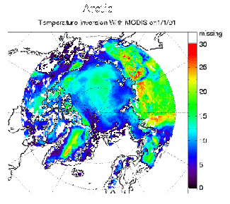 |
Low-level atmospheric temperature inversion strength (temperature difference across the inversion) in degrees Centigrade over the Arctic for one winter day estimated from MODIS. Click on the image for both Arctic and Antarctic images. |
Papers—“Cloud-drift and Water Vapor Winds in the Polar Regions from MODIS” was accepted for publication, subject to minor revision, in the IEEE Transactions on Geoscience and Remote Sensing for a special issue on the Aqua satellite. The authors are J. Key (NOAA’s Office of Research and Applications, stationed at SSEC) D. Santek (SSEC’s CIMSS), C. Velden (CIMSS), N. Bormann (European Centre for Medium-Range Weather Forecasts, ECMWF), J.-N. Thepaut (ECMWF), L. P. Riishojgaard (NOAA’s Data Assimilation Office, DAO), Y. Zhu (DAO), and W. P. Menzel (NOAA’s ORA, at SSEC). The paper describes how wind information can be obtained from polar-orbiting imaging instruments, specifically the Moderate Resolution Imaging Spectroradiometer (MODIS), and provides results from model impact studies at ECMWF and DAO.
“Aggregate-Area Radiative Flux Biases” has been published in the Annals of Glaciology (2002, vol. 34), authored by X. Wang (CIMSS) and J. Key (NOAA). It proposes a method to adjust for the radiative flux biases in climate models that can result from subgrid cell variability in surface and cloud properties.
Education, Outreach
GLOBE Training—In early August, Sanjay Limaye and Margaret Mooney of SSEC’s Office of Space Science Education gave their second GLOBE training workshop in Hayward, Wisconsin, at the Lac Courte Oreilles Ojibwa Community College. Participants included a teacher from Turkey. Dr. Dixon Butler, GLOBE Director and Chief Scientist from NASA headquarters trained participating teachers in Atmosphere and Climate Protocol. GLOBE, the Global Learning and Observations to Benefit the Environment program, has participants from 10,000 schools around the world.
Honors, Awards
Suomi-Simpson fellowship—Shaima Nasiri, a graduate student pursuing a doctoral-level degree in UW–Madison’s Department of Atmospheric and Oceanic Sciences, has received the first Suomi-Simpson Graduate Fellowship, sponsored by UW–Madison and NASA.
The grant is named for the late Verner E. Suomi, founding director of the University of Wisconsin–Madison’s Space Science and Engineering Center and emeritus professor in the Department of Meteorology and for Joanne Simpson, Chief Scientist for Meteorology in the Goddard Space Flight Center’s Earth Sciences Directorate. The two meteorological giants maintained a career-long collaboration, Simpson said, starting with the instrument course she took from Suomi in 1946.
According to Nasiri, “This fellowship creates a direct line between me and scientists at Goddard Space Flight Center.” She will work with scientists in Goddard’s Earth Observing System program, primarily Michael King, NASA’s EOS senior project scientist, and scientist Steven Platnick. Besides enhancing collaboration, the fellowship will enable travel to and from Wisconsin and Goddard, near Washington, D.C., as well as field experiment sites.
For her research toward her atmospheric science Ph.D., Nasiri studies overlapping clouds, phenomena difficult to discern in satellite data in any conventional way. She hopes to improve retrievals of cloud properties that are used to create cloud climatologies. She explained that “current satellite retrieval schemes assume one layer of cloud.” Nasiri seeks a solution that will work globally. She also wants to help increase the usefulness of the MODIS instrument on board NASA’s earth observing satellites used to provide information about global cloud cover to improve climate models. This will help her collaborators at Goddard, where the Earth Observing System is being used to study climate change issues.