Monthly News Summary – August 2002
Still Monitoring Fires
by Terri Gregory, SSEC Public Information Coordinator
Wildfires—After a 3-month review of the Wildfire Automated Biomass Burning Algorithm (WF-ABBA) product, NOAA’s Satellite Products and Services Review Board approved the transition from preoperational to operational status. The WF-ABBA will become officially operational in September. According to team leader Elaine Prins (NOAA, at SSEC), “This effort represents a wonderful example of effective collaboration between NOAA’s Office of Research Applications, Cooperative Institute for Meteorological Satellite Studies (CIMSS), and the Office of Satellite Data Processing and Distribution’s Satellite Services Division in the transition of experimental products into operations.” Prins and Chris Schmidt and Joleen Feltz (CIMSS) are permanent members of the team that monitors biomass burning, including forest fires, with geostationary weather satellite data.
Upon first use of the fire imagery produced by the CIMSS WildFire algorithm, Roger Hill, an independent forecaster with Weathering Heights Consulting in Worcester, VT, sent this feedback: “We can now see the fires were extinguished using your animated loop and can determine that the smoke plumes will be thinning. This is an excellent product to use to forecast with. Temperature forecasts will be cut down some by lack of solar insolation at my location and to determine exactly where source fires were is very helpful to me as a private meteorologist.” In early July, Vermont was under the smoke plume from fires in Quebec.
Waitsfield, Vermont also experienced the smoke and haze from the Canadian wildfires. Kitty Werner, editor of Waitsfield’s Vermont Journal, asked to use an image in the paper for the week of July 7.
An edited version of the June SSEC news release appeared on OE magazine, the Web site of SPIE, the International Society for Optical Engineering. Rocky Mountain News.com of Denver, CO published a straight-forward explanation of the technique. All Hallows Academy, a Catholic school in La Jolla, CA lists the WF-ABBA Web site in an eclectic group of science resources. Science Update, an on-line radio service of the AAAS (American Association for the Advancement of Science), features the wildfire technique this week. Click on August 1.
Prins, Schmidt and Feltz created half-hourly fire products for the month of June 2002 to map the extent of fire activity as observed by GOES. The composites clearly show the extent of the large wildfires that burned throughout the Western U.S. Many conflagrations were detected as saturated pixels in data from the GOES-8 3.9 micron channel.
 |
Click for collage. |
The group has submitted “A two-year analysis of fire activity in the Western Hemisphere as observed with the GOES wildfire automated biomass burning algorithm” to the American Meteorological Society (AMS) 12th Conference on Satellite Meteorology and Oceanography (2003). The paper provides an overview of half-hourly WF-ABBA fire statistics for the western hemisphere for the time period September 1, 2000 through August 31, 2002. It also highlights current applications of the technique for real-time fire detection and monitoring, air quality and aerosol model data assimilation activities, and applications in land-use and land-cover change studies.
Elaine Prins chaired a session of an international workshop held at the University of Maryland in College Park July 17 through 19 on the Biomass Burning Experiment (BIBEX), sponsored by two international science working groups: Global Observation of Forest Cover/Global Observation of Landcover Dynamics (GOFC/GOLD) and the International Geosphere Biosphere Program’s (IGBP) International Global Atmospheric Chemistry group. Prins chaired the session on satellite-derived fire area estimates and presented an invited poster on WF-ABBA applications in the western hemisphere. The workshop focused on better understanding aerosol and trace gas emissions during biomass burning using satellite, emissions modeling, assimilation into global and regional transport models, and validation of satellite products and models. The GOFC Fire Implementation Team met during the workshop to discuss main objectives; they agreed that a primary focus over the next year would be multisatellite product intercalibration and validation.
For the past 4 years Environment Canada’s Quebec Region has worked with SSEC’s NOAA group, the Advanced Satellite Products Team (ASPT), and SSEC’s CIMSS to evaluate the Wildfire Automated Biomass Burning Algorithm (WF-ABBA) for its ability to detect and monitor fires at northerly latitudes using geostationary weather satellite (GOES) data. During the recent outbreak of wildfires in Quebec, M. Moreau (Environment Canada) indicated that the GOES WF-ABBA was an excellent tool for monitoring fires in real time especially in the restricted protection zone in northern Quebec where conventional fire monitoring is limited. Moreau said that the latest version of the algorithm has significantly fewer false alarms and agrees well with ground truth verification information. Elaine Prins (NOAA, at SSEC) and Chris Schmidt (CIMSS) plan a detailed comparison with ground truth information for the end of the fire season.
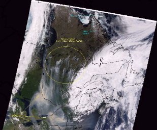 |
MODIS image taken by SSEC’s direct broadcast facility on 6 July 2002. The yellow circle encloses active fires with their smoke plumes. Click on image for full-size version. |
Watch the NOAA magazine for an article on the use of the WF-ABBA to track the progress of wildfires.
Antarctica
The iceberg pages of SSEC’s Antarctic Meteorological Research Center are planned to be cited in Ice Island: Journey to the Largest Iceberg in History. In particular, we expect the New England Aquarium to use Douglas MacAyeal’s motion information. MacAyeal is our glaciologist colleague with the University of Chicago. This book by Greg Stone, vice president of the New England Aquarium, is about his latest Antarctic expedition.
Data and Imagery
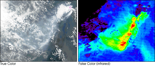
NASA’s Terra satellite’s MODIS instrument caught Nyamuragira Volcano as it erupted in eastern Congo, near the Rwandan border. Bryan Baum (NASA, stationed at SSEC) and Liam Gumley (SSEC) produced the July 26th image. Kathleen Strabala retrieved the data from Goddard Space Flight Center’s archive. The team used the difference between two channels (one at 8 microns, another at 11 microns) to show the plume. The Jet Propulsion Laboratory saw the images and hopes to use the technique to estimate the amount of sulphur dioxide in volcanic plumes.
 |
The Minnesota Science Museum is presenting Playing with Time, an interactive exhibit produced by Red Hill Studios, an educational multimedia production company in Sausalito, CA. SSEC’s Data Center provided daily satellite data; it can’t be found on the Web site, however. The National Science Foundation funded the exhibit, which is in place in St. Paul till August 25.
The Exploratorium, San Francisco’s premier “museum of science, art, and human perception,” uses SSEC imagery in its on-line exhibit on global change. This excellent presentation is too complex to be called an overview—it truly explains climate change research in detail and in depth and without much jargon. SSEC’s sea surface temperature composite image is used in the section on the hydrosphere, and imagery from the CIMSS group that monitors biomass burning with GOES is used in the biosphere section. NSF funded the exhibit.
Grolier Publishing will use SSEC’s global montage in a new 16-volume set children’s encyclopedia.
Instrument Development
SSEC scientist Lawrence Sromovsky has compared measurements from the Planetary Imaging Fourier Transform Spectrometer (PIFTS) breadboard (prototype) instrument with observations from SSEC’s ground-based non-imaging FTS, the Atmospheric Emitted Radiance Interferometer (AERI). The field experience with real imaging FTS data compared with simultaneous observations by the highly accurate AERI can help to evaluate instrument design trade offs, calibration procedures and data handling algorithms for future imaging FTS systems. A comparison of data taken on a clear day by both AERI and PIFTS shows excellent radiance agreement between them.
Weather Experts
Weather Guys Steve Ackerman and Jonathan Martin appeared on WHA-AM radio on July 29. With host Larry Meiller, they discussed SSEC’s CIMSS contributions to monitoring the movement of wild fires. Also, the Guys fielded questions on lightning, predicting fog (you can’t), and a variety of other weather phenomena. Larry Meiller shows are archived on line. You must access them through Webcasting. Click on Larry Meiller and, to find Weather Guys shows, hunt for last Monday of the month shows starting at 11:45 a.m. or search on Weather Guys.
Weather Research
Polar Science—A current study shows that better observations over the earth’s poles can improve forecasts in the midlatitudes. In the experiment, an area of large differences in the 500 hPa (500 millibars of pressure above the earth’s surface) geopotential height between forecasts with and without wind measurements from the Moderate Resolution Imaging Spectroradiometer (MODIS) propagated from the Beaufort Sea north of Alaska to the Gulf of Alaska and the north Pacific Ocean over a 5-day period. Niels Bormann of the European Centre for Medium-Range Weather Forecasts (ECMWF) in England provided a case study that showed how errors in forecasts can propagate from the Arctic to the midlatitudes when the (MODIS) polar winds data are not used in the initial analysis. Dave Santek and Chris Velden (SSEC/CIMSS) and Jeff Key (NOAA team leader at SSEC) produced the wind information used in Bormann’s study.
Hurricane Research—CIMSS satellite techniques are being transferred to National Hurricane Center (NHC) operations as part of the U.S. Weather Research Program’s Joint
Hurricane Test-bed. Chris Velden and Tim Olander (CIMSS) provided seminars and training at the NHC on the two primary modules: the Advanced Microwave Sounding Unit hurricane intensity estimation algorithm and the Advanced Objective Dvorak Technique. Both methods are showing promise to hurricane forecasters and will be tested in real time this coming hurricane season. The CIMSS Tropical Cyclones group, led by Velden, has worked with the NHC since the early 1980s, developing ever more detailed and precise weather satellite techniques for hurricane and tropical storm forecasts.
Papers—The CIMSS Polar Science group have submitted abstracts on Arctic meteorology and climatology to the American Meteorological Society’s (AMS) Conference on Satellite Meteorology and Oceanography, to be held at the AMS Annual Meeting in February 2003. The papers are titled, “Simulation of the Antarctic climate using the Arctic Region Climate System Model (ARCSyM) and the AVHRR Polar Pathfinder (APP) data set,” by Michael Pavolonis (CIMSS) and Jeff Key; “Impact of Polar Cloud Track Winds from MODIS on ECMWF Analyses and Forecasts,” by Dave Santek, Jeff Key, and Chris Velden; and “Recent Arctic Climate Trends Observed from Space, 1982-1999,” by X. Wang (CIMSS) and Jeff Key.
Mat Gunshor (CIMSS) and Dave Tobin (SSEC) and Tim Schmit and W. Paul Menzel (NOAA) submitted an abstract to the 12th annual AMS satellite conference for a poster on satellite intercalibration. The poster authors compare the GOES Imager with the Atmospheric Infrared Sounder (AIRS) now flying on NASA’s newly launched Aqua satellite.
Several other abstracts concerning GOES research have been submitted to the satellite conference: “Introducing the Geostationary Operational Environmental Satellite (GOES) Imager Clear-Sky Brightness Temperature (CSBT) Product,” “Channel selection for the next generation geostationary Advanced Baseline Imagers,” “GOES-11 and GOES-8 Sounders During the International H2O Project (IHOP)-2002 Field Experiment,” “Surface and Atmospheric Retrievals from the Future GOES Sounder—Advanced Baseline Sounder (ABS)” and “Vegetation Monitoring and Thin Cirrus Detection on the Next Generation GOES Imager.” Authors include several from the NOAA/NESDIS group stationed at SSEC and from SSEC’s CIMSS. An undergraduate student has authored one paper.
Education, Outreach
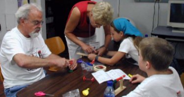
SSEC’s Office of Space Science Education (OSSE) presented a series of workshops to train teachers in Project GLOBE, Global Learning and Observations to Benefit the Environment. In this worldwide network, students, teachers and scientists work together to study and understand Earth’s environment. Students take measurements which are used as “real data” in scientific studies. SSEC’s Margaret Mooney gave a workshop in July at Madison’s Georgia O’Keefe Middle School that focused on hydrology. Teachers took measurements in the nearby Yahara River.
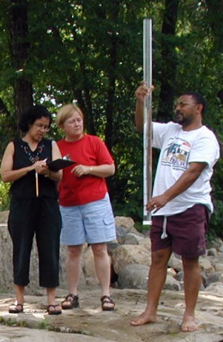 |
Teachers Akeda Isaacs, Lynne Nowakowski and Ronald Engelbrecht take hydrological measurements in Madison’s Yahara River. Isaacs and Engelbrecht teach high school in Cape Town, South Africa. Nowakowski teaches at Sherman Middle School. In the larger version, teachers at the left of these three are Tracy Cavalier, Racine R.E.A.L School (far left) and Maggie Prevanas, Azalea Middle School, Brookings OR.(Photos by Margaret Mooney) |
Worldwide, more than a million students and 16,000 teachers have taken part in the GLOBE program. In Madison, teachers attended from Madison, the state of Oregon and South Africa.
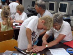
SSEC’s OSSE took part in Grandparents’ University in mid-July, teaching children and grandparents together at Space Place. OSSE Director Sanjay Limaye led the group in interactive activities oriented toward planetary exploration.
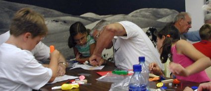
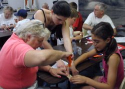
Grandparents work interactively with grandchildren to build balloon-powered cars to learn how spacecraft are propelled. (Photos by Margaret Mooney)
In July, Matthew Lazzara spoke about his Antarctic activities at Space Place. His talk is on the Internet. At a later time, video of the talk will be posted on the Web. For now you must have PowerPoint on your computer to access the talk. Even without the video, the presentation gives many details and facts about work and research on the icy continent.
EAA Visit—Among the 750,000 visitors to the EAA’s 50th AirVenture in Oshkosh Wisconsin in July were a handful of University of Wisconsin–Madison employees, exploiting the presence of NASA’s DC-8 research aircraft. Flying at cloudtop altitudes (35,000–40,000 feet), the DC-8 carries research instruments, including SSEC’s Scanning-High Resolution Interferometer (S-HIS), in field experiments to learn more about specific atmospheric conditions. In June, the plane and its payload had taken part in SMEX, the 2002 Soil Moisture Field Experiment in and around Iowa. Before heading back home to Dryden Research Center in California, the plane, its crew and other NASA personnel made a week-long stop at the annual gathering of pilots and planes, presenting a perfect opportunity for SSEC to showcase its own activities.
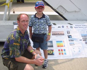 |
SSEC/CIMSS researcher Erik Olson and friend in front of SSEC display at AirVenture in Oshkosh. |
Lines to see the plane were short but constant and appreciative. Before or after touring the plane, people stopped at SSEC’s eye-catching posters that described its airborne-instrument science. Mostly people looked and listened, but they asked questions, too:
“What do you measure? What basis do you use?” “Do you do any studies of the ozone layer or temperature inversions?” “What kinds of science do you do with this airplane?” “What kind of instruments does it have on it?” “Do you learn about forest fires with this?” Others wanted to know what field experiments were being planned. An engineer from NASA’s Marshall Space Flight Center asked if it could be used to measure engine emissions.
Some seemed shocked, surprised, bemused, or just pleased that this was “out of UW–Madison.”
An off-duty nurse read the posters, asked questions till she was satisfied she understood, then noted the importance of good P.R. in having the public appreciate science.
A visitor from Norway was surprised and impressed that the U.S. freely shares its data. Twice he asked, “Who pays for the data? How much do you charge?”
Because UW staff were standing close to the NASA plan, many convention goers asked us about the plane. “How often does this fly?” “How high does it fly?” “Have you gone all over the world?” “Where does it fly out of?” “How fast does it go?” “What’s the budget?” We cheerfully deferred these questions to the NASA crew.
A UPS pilot said, with a hint of envy, “You get to fly these during the day, not at night, like we do.” He also told how he used satellite images and other weather information to plan his flights around and through clouds, alluding to the practical applications of SSEC’s weather research.
Some visitors summed up what they’d heard: “So, you learn more about storms, you can predict where they’re going to go…?” ”It’s an interesting field.” “So, you study the weather?”
You can learn about SSEC’s airborne and ground-based interferometers on the Scanning HIS and AERI Web sites.
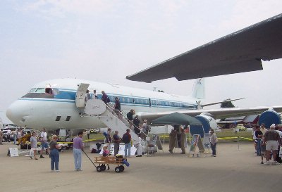
NASA’s DC-8, a research plane that flies about cloudtop level. Overshadowing wing is on a large military tanker parked close by. (Photo by Erik Olson)