Monthly News Summary – May/June 2002
Got Water Vapor?
by Terri Gregory, SSEC Public Information Coordinator
This issue of In the News covers news and events from April and May 2002. Also see Features for stories appearing in those months about icebergs calving, remote sensing in high-spectral resolution, and more IHOP 2002. Use images freely with credit to the Space Science and Engineering Center, University of Wisconsin–Madison.
IHOP 2002—Gary Wade (NOAA, stationed at SSEC), Wayne Feltz (CIMSS) and other SSEC researchers are providing satellite products for the International H2O Program (IHOP), taking place in May and June over the U.S. southern Plains states. The group is providing near real-time animations and intercomparisons of Geostationary Operational Environmental Satellite (GOES) products derived from the GOES sounding instrument to IHOP organizers. These displays for the most recent six hours are specifically focused over the Oklahoma, Kansas and Texas Panhandle region for both forecasting assistance as well as product assessment. It is hoped that increased exposure to displays of derived product imagery at its full resolution, purposefully enlarged over the study area, will encourage wider evaluation and acknowledgment of the value-added benefits as well as the deficiencies of current GOES Sounder data.
CIMSS researchers Gail Bayler and Jim Nelson with Tim Schmit and Gary Wade of NOAA are producing “single-field-of-view” retrievals from sounder information. This higher resolution imagery focuses on a smaller geographical area and provides more detail than the traditional product. These new products derived for total precipitable water and lifted-index stability have also been added to the standard larger scale animations on the CIMSS Real-time GOES Page where they can be compared to traditional 3×3 field-of-view products derived from satellite information. Besides real-time data, animations from a recent preseason situation over the IHOP area (16-17 April 2002) are available. These efforts are only a small part of CIMSS’s participation in IHOP.
SSEC participated remotely in press day, May 13, with a news release. Dave Tobin, stationed with the AERIBago in the Oklahoma Panhandle, spoke with media and appeared on Amarillo, TX television news. SSEC’s contributions were also mentioned in releases from the University Corporation for Atmospheric Research and Dryden Flight Research Center.
In the field, the AERI observed the atmosphere in its signature spectra on May 23. Winds were strong northeasterly, skies were generally clear with temperatures in the 60s (F). That afternoon a surge of moisture returned close to the ground causing rapid destabilization just southeast of the AERIBago site.
 |
A strong moisture gradient at about 12.0 UTC (middle of image, vertically) on May 23 indicates a rapid drying in the atmosphere.This image shows moisture (or its lack) in the atmosphere. Click for an image showing both temperature (top) and moisture, called mixing ratio (bottom). Meteorologists use both together for the whole picture of atmospheric instability. |
After the front passed through the morning of May 23, Wayne Feltz and Tom Achtor (SSEC’s executive director for science) and student researcher Robin Tanamachi “chased” a storm to Follet, TX. Besides getting data, they documented golf ball size hail.
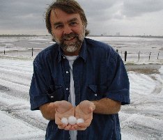 |
Tom Achtor, SSEC executive director for science, demonstrates size of hail in Oklahoma/Texas storm, May 23, 2002. |
’Tis the Season
UW–Madison’s Why Files pays tribute to baseball in an April feature. The on-line educational resource looked at the physics of the all-American pastime. Try out the on-line ball game, fueled by Tom Whittaker’s Java applet and see how altitude changes your fast or curve ball pitch. Careful—it’s habit forming. Elsewhere in the pages, Tom Achtor, an avid baseball fan, explained how technology and skill have made it much easier for baseball fans to know what weather to expect for their games. And associate scientist Tom Zapotocny, another fan, explains why it’s hard to forecast rain, snow or any other precipitation.
Weather Events
Lake fog—Southerly flow of unseasonably warm, moist air across the cold waters of the Great Lakes led to the development of large plumes of advection fog on April 16, 2002. GOES images were taken every few minutes, allowing the evolution of the fog plumes to be closely monitored, while the less frequent but higher-resolution MODIS imagery revealed striking detail in the fog structure resulting from complex interactions between wind and coastline. “Advection” describes what happens when warm air blows over a cold surface. The air near the ground cools and fog forms. Scott Bachmeier analyzed the weather situation on the CIMSS GOES Gallery. NASA’s Earth Observatory Web site, which has been nominated for a Webby award, featured the MODIS imagery on April 22.
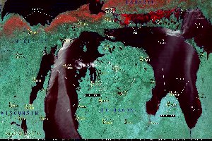 |
Moderate Resolution Imaging Spectroradiometer (MODIS) 500 m resolution, 3-band composite image of advection fog over Lake Michigan on April 16, 2002 |
The tornado that struck La Plata on April 28, 2002 was the first F-5 tornado ever recorded in Maryland. The imagery from GOES-8 was available every 5–10 minutes during the event. The satellite, which usually sends images of a whole hemisphere every 20 minutes, had been placed into Rapid Scan Operations mode earlier in the day, taking images of a severe weather region very often. An “enhanced-V” cloud-top signature was evident in the La Plata storm on the infrared imagery, but not until 23:10 UTC, after the “super cell” became tornadic. Images from GOES, MODIS, and the Advanced Very High Resolution Radiometer on the NOAA polar-orbiting satellite are available on the CIMSS GOES Gallery.
Wildfire detection—From December 2000 through February 2001, large wildfires consumed millions of acres of grasslands in central Argentina producing large smoke palls that extended over the South Atlantic Ocean. Elaine Prins (NOAA, at SSEC and leader of its biomass burning monitoring group) and Joleen Feltz and Chris Schmidt (SSEC) prepared a three-month summary of the fires, detected by the GOES-8 Wildfire Automated Biomass Burning Algorithm (WF_ABBA, a technique developed by university and NOAA researchers).
The researchers provided their summary to L. Moxey, a graduate student at the University of Hawaii, as part of a collaborative effort to assess the affected area. Moxey is comparing multispectral satellite data and satellite-derived fire and vegetation products from a variety of remote sensing instruments, operational and experimental, and in coarse and high spatial resolution. This study strives to see how remote-sensing data from a variety of instruments can be applied to wildfire detection and mitigation, surface change detection, and the creation of environmental impact and hazard maps.
 |
This composite image shows wildfires detected by the GOES Wildfire ABBA from December 1, 2000 through February 28, 2001 in Central Argentina. Click on image for more information. |
Polar Winds—Lars Peter Riishojgaard of NASA’s Data Assimilation Office reports that polar wind measurements from MODIS have a positive impact on short-range forecasts over the Arctic and Northern Hemisphere (outside the tropics) for the case study period March 5–April 3, 2001. These results are similar to what was previously reported for the European Centre for Medium-Range Weather Forecasts impact study. The DAO also demonstrated that the forecast impact for Antarctica is slightly positive.
Weather—CIMSS researcher John Mecikalski spoke with Janesville Gazette reporter Mike Dupree about weather conditions. The article was to have run in late April.
Records—SSEC’s Scott Lindstrom reported that April 16’s low temperature of 66 at Truax Field (Dane County airport), was the warmest low on record for April. It tied the low of 66 on April 5, 1929. The rest of April and May produced no more warm records.
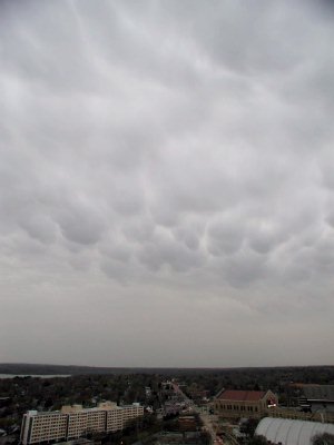 |
View from roof of the Atmospheric, Oceanic and Space Sciences building, which houses SSEC, the Department of Atmospheric and Oceanic Sciences and research centers in the Institute for Environmental Studies. Taken on April 18, a particularly threatening day in early spring 2002. (C. Schmidt) |
Antarctica
New icebergs—A large part of the Ross Ice Shelf calved as iceberg C-19 on May 10, bringing the extent of the shelf to roughly the size it was in 1911 when Robert Scott Falcon visited, according to Antarctic scientists. Linda Keller, a researcher with the Department of Atmospheric and Oceanic Sciences (AOS), discovered the new berg when she posted the morning’s satellite image to SSEC’s AMRC iceberg page. Ernest Mastroianni of the Milwaukee Journal Sentinel covered the break on Sunday, May 12.
Reuters News Service contacted SSEC Friday, May 10. On May 13, the new calving and UW–Madison’s discovery of it was featured in the New Zealand Herald, Toronto’s Globe And Mail, Reuters in the United Kingdom, and in the U.S. UniSci featured the SSEC release, but incorrectly named the new iceberg. It should be C-19. The UniSci Web site features university science news and is published by UniScience News Net, Inc., FL.
The History Channel’s “Antarctica, a Frozen History,” features Jonathan Thom (SSEC) and Douglas MacAyeal, University of Chicago glaciologist placing Automatic Weather Stations and other equipment on iceberg B-15 in January 2001. Thom and MacAyeal appear both in the program and in advertisements. Their work was also noted in CBS and NBC national news programs in March.
The Antarctic Meteorological Research Center provided a NOAA satellite image of B-15 and related icebergs to NASA’s Goddard Space Flight Center for an April 16 article on the affect of those bergs on oceanic plant life. This NASA research focuses on how iceberg calving is keeping phytoplankton from blooming. Scientist Emile Okal also uses an image in a paper in Science magazine.
Susan Solomon, NOAA scientist who wrote The Coldest March, notes that she was able to make temperature comparisons because the Automatic Weather Station had been invented. She used “that information together with the records left by Robert F. Scott’s meteorologists” to show that Scott and his team “were caught in a very unusual and prolonged cold event on their return journey from the [South] Pole,” she said in an essay, “Writing The Coldest March,” in the Bulletin of the American Meteorological Society (May 2002).
Data and Expertise
The exhibit Playing With Time opened at the Science Museum of Minnesota in St. Paul in mid-March and uses SSEC imagery. It runs until the end of August when it moves to science museums in Durham, North Carolina (till January 2003) and Berkeley, California, traveling around the country until 2009. SSEC’s work is not included in the searchable on-line examples.
The Tokyo Science Museum has produced a video promoting the Geocosmos globehanging in the Museum. The video gives information on the 6.5 meter (21 feet) globe and the weather satellite data that SSEC provides.
A new National Weather Service (NWS) Web site for American Samoa shows animated forecast model output graphics and satellite imagery. Tom Whittaker (CIMSS) developed the Java animation applet that enables the interactive viewing. The NWS Honolulu forecast office supplies the data, a critical requirement for forecasters in American Samoa and Western Samoa to issue local public, marine and local tropical cyclone warnings, according to the NWS Pacific Region weekly report and the NWS main communications page.
Space News reporter Rich Isaacman interviewed Liam Gumley for an article onEOSDIS, NASA’s Data and Information System for Earth Observing System data. Isaacman focused on user frustration with EOSDIS, which provides data to researchers several days after it is acquired, according to Michael Keebaugh of Raytheon. Isaacman’s article stated that Gumley, MODIS direct broadcast project manager, “is seeing researchers turn to direct broadcast who do not have a pressing need for live data.” In background for the article, Gumley explained that SSEC became a direct broadcast facility for MODIS data to complement current work. SSEC has a well-developed database of satellite data, is the national archive for U.S. geostationary satellite data and provides data in real time. Moreover, SSEC, through its Cooperative Institute for Meteorological Satellite Studies, is a premier locale for atmospheric research using atmospheric satellite data. Also, SSEC develops software (IMAPP) to make the data useful to scientists. Having EOS direct broadcast ability adds to extant capabilities.
Images from the CIMSS Web site, including one from the GOES Gallery, have been selected to illustrate Robert Rauber’s college textbook, Severe and Hazardous Weather.The book is due out this summer, published by Kendall/Hunt Publishing Company of Dubuque.
Legacy
NASA and SSEC are cited in an article on technology transfer in the Bulletin of the American Meteorological Society (March 2002). The article (page 389) mentions the important part that R&D organizations have in developing observing systems. It cites NASA and UW–Madison’s SSEC as great examples of the transition of research to operations, stating that they are “indispensable in the development of earth satellite systems.”
An article by Professor John Harries of Blackett Laboratory’s Space and Atmospheric Physics Group, London, mentions SSEC founding director Verner E Suomi. The article will appear in the Century of Space Science, slated for publication in June 2002 by Kluwer Academic Publishing.
A celebration of GOES I–M accomplishments noted the contributions of Verner E. Suomi to satellite meteorology. ITT hosted the presentation at the Smithsonian’s Air and Space Museum in Washington, DC on May 15.
Neutrino News
Wired magazine is featuring construction of the new South Pole Station in its July issue which comes out around the 15th of June. Francis Halzen, principal investigator fo rIceCube, spoke with Wired editor Jeremiah Steele.
FYI—In a Congressional hearing held in April, James Walsh (R-NY) asked National Science Board Chairman Eamon Kelly to explain why funding had not been requested for IceCube R&D and the High-performance Instrumented Airborne Platform for Environmental Research. Walsh lauded Kelly for his Board chairmanship, noting that he helped secure larger budgets for the foundation, but pressed him for an explanation of how priorities are set. As reported in FYI, an online report of the American Institute of Physics, Walsh and others were somewhat critical of NSF’s inability to adequately fund high priority research projects.
Jodi Cooley, physics graduate student, explained neutrino science to physics students at Winona High School. She introduced them to “the first in a new generation of telescopes,” AMANDA. The Winona Daily News covered the talk.
Weather Guys
Weather Guys—Weather Guys Steve Ackerman and Jonathan Martin appeared not only on Wisconsin Public Radio in April and May, but in Wisconsin Week, the campus newspaper. University Communications’ Katie Zimmerman wrote about the Guys’ appearance on Larry Meiller’s WHA call-in show the last Monday of each month, when they field a wide variety of audience questions. Ackerman, who teaches in UW–Madison’s Department of Atmospheric and Oceanic Sciences (AOS) and directs the Cooperative Institute for Meteorological Satellite Studies, attributes the show’s success to its “ordinariness … Everybody has common experiences with the weather.” Martin, also a professor in AOS, agrees: “I’m not sure there’s another thing that occupies people’s minds quite as frequently as the weather.” Meiller said that, even under a barrage of questions, the Guys “are rarely—if ever—at a loss for words.” Wrong in the article, the Guys actually appear at 11:45 a.m. every last Monday of the month, in Madison on 970 AM or 90.7 FM or on the Internet.
On the Web, the Weather Guys are listed among Larry Meiller’s regular guests. Their story appeared in Wisconsin Week Wire on April 24. It was also included in the UW–Madison News Release Daybook for April 27–May 12 and was released regionally on May 1. Melva Lara, anchor for the Wisconsin portion of NPR’s All Things Considered,quoted Ackerman and Martin on April 28, on comments they gave on “global warming.”
Weather Research
VISITView—Tom Whittaker has released a major upgrade to the software used by the National Weather Service in its teletraining programs for forecasters. The release uses Java2 software and enables the use of additional image file formats (Portable Network Graphics (PNG) and PowerPoint 2000). It also contains audio processing code to remove unwanted high-frequency elements of recorded audio. Other changes included additional code for assisting in the construction of overlays and “tear-off controls” that are more consistent across platforms.
Monitoring Forest Fires—Most false fire alarms in North America are typically made in spring and fall. They are often associated with reflection off clouds under extreme view-angle conditions and at sunrise and sunset. As part of NOAA’s pre-operational evaluation of the WildFire ABBA (Automated Biomass Burning Algorithm), comparisons of versions 5.9 and 6.0 have shown improved performance with version 6.0 for both GOES-8 and GOES-10 during May. The latest version eliminates many false alarms detected under extreme view-angle conditions at sunrise and sunset. Elaine Prins (NOAA) and Chris Schmidt (CIMSS) analyzed experimental fire products generated since August of 2000.
AGU papers—CIMSS and NOAA researchers who monitor biomass burning with the Geostationary Operational Environmental Satellite (GOES) have submitted four abstracts to the American Geophysical Union (AGU) annual meeting held in May 28–31, 2002 in Washington D.C. Elaine Prins, Joleen Feltz and Chris Schmidt submitted three abstracts to the special session, “Fires, Scars, and Smoke: Observations, Impact, and Policies.” They present an overview of the GOES Wildfire Automated Biomass Burning Algorithm (WF-ABBA) processing system and comparisons of GOES WF-ABBA fire observations with carbon monoxide values derived from downwind Measurements Of Pollution In The Troposphere (MOPITT).The third is an invited talk on recent GOES fire monitoring activities and applications in the Western Hemisphere. Their fourth abstract was submitted to the session, “AERONET: Aerosol Observations, Related Investigations, and Synergism,” regarding aerosol measurements derived from GOES-8 measurements in North and South America compared with sun photometer data taken during two field campaigns.
FLAMBE—Elaine Prins (NOAA, at SSEC, lead scientist for the group who monitors biomass burning) and Chris Schmidt (CIMSS) are authors on the presentation of Project FLAMBE, or Fire Locating and Monitoring of Burning Emissions. According to Jeffrey Reid of the U.S. Navy’s Space and Naval Warfare Systems Center, San Diego, “FLAMBE is one of the few projects to take real-time satellite data and put it into a real-time aerosol forecast model. While we emphasize the relationship between smoke and weather, we are also working to estimate burned areas, smoke fluxes and radiative impacts, climate effects, and assess regional air quality.” The GOES Automated Biomass Burning Algorithm (ABBA), developed in the Cooperative Institute for Meteorological Satellite Studies by NOAA and UW–Madison researchers, forms the basis for FLAMBE model input. Smoke production estimates based on the ABBA data are integrated into a Naval Research Laboratory transport model that allows scientists and meteorologists to give early warnings of haze events downwind. “It is also the first product that can provide estimates of biomass burning particle emissions,” said Elaine Prins of the NOAA NESDIS Advanced Satellite Products Team and lead scientist of the Wildfire ABBA monitoring program. FLAMBE news was released by NASA’s Rob Gutro of the Goddard Space Flight Center on May 28.
Polar winds—The paper, “Cloud-drift and Water Vapor Winds in the Polar Regions from MODIS” was submitted to IEEE Transactions on Geoscience and Remote Sensing, for a special issue on NASA’s newly launched Aqua satellite. The paper describes how wind information can be obtained from polar-orbiting imaging instruments, specifically MODIS, and provides results from model impact studies at ECMWF and NASA’s Data Assimilation Office. Authors are Jeff Key (NOAA’s Office of Research and Applications, ORA, stationed at SSEC), Dave Santek and Chris Velden (SSEC’s CIMSS), N. Bormann and J.-N. Thepaut (European Centre for Medium-Range Weather Forecasts), L.P. Riishojgaard and Y. Zhu (Data Assimilation Office), and Paul Menzel (ORA).
Tropical Cyclones—Later this year, the American Geophysical Union is publishingCoping With Hurricanes, An Historical Analysis of 20th Century Progress, edited by Robert Simpson, Richard Anthes and Michael Garstang. Chapter 11, “The Burgeoning Role of Weather Satellites,” was written by Chris Velden (of SSEC’s CIMSS), Joanne Simpson, W. Timothy Liu, Jeff Hawkins, Kurt Brueske and Richard Anthes.
Outreach
A group of UW–Madison engineering and chemistry students were selected for a NASA student payload. According to SSEC’s executive director for technology, “This program solicits a wide range of student projects and provides funding and flights on NASA’s Zero-G simulation aircraft (aka Vomit Comet) for winning concepts.” Stephen Steiner (Chemistry) and Nick Kho (Engineering) lead the group who have been using SSEC basement shop facilities to develop their payload, called Zero-G Aerogel. The group is trying to perfect a substance that is light and strong but brittle and blue. The student group hopes to show that a clear, hence more salable, product can be made in zero gravity. The National Geographic cable channel devoted a half-hour to student projects including theirs on May 8.
SSEC Outreach—Earlier this spring, Margaret Mooney of SSEC’s Office of Space Science Education gave a series of programs to local Girl Scouts in cooperation with NASA. The April 13 presentation at UW–Madison’s Pyle Center focused on geology and was attended by 4 Blackhawk Council Girl Scout troops.
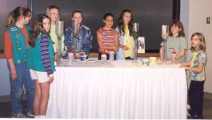 |
Blackhawk Council Girl Scouts experiment with infiltration properties of Wisconsin’s glacial soils. |
PTA help—SSEC employees participated in Weather Night at Elm Lawn Elementary School in Middleton, WI. Robert Aune (NOAA, stationed at SSEC) organized the PTA-sponsored event, held Tuesday evening, April 9. A half-dozen research meteorologists treated students to various examples of how modern technology is used to measure atmospheric parameters and predict tomorrow’s weather. High-resolution images from MODIS and GOES, projected on large screens, were very popular. The event also included the chief meteorologist, Bob Lindmeier, from Madison’s NBC-TV affiliate, and material from the National Weather Service office in Sullivan, WI. The Middleton-Cross Plains newspaper, the News-Sickle-Arrow, covered the event, with pictures.
Honors and Service
 Award —CIMSS researcher Tony Schreiner has been named Team Member of the Month for NOAA’s National Environmental Satellite, Data, and Information Service for June 2002. Schreiner was nominated by NOAA workers who work with CIMSS scientists at UW–Madison for his “significant contributions to NESDIS’ mission through the development and generation of cloud products derived from the NOAA Geostationary Operational Environmental Satellite (GOES).” He was especially recognized for accomplishments over the last year, when he “developed the new GOES clear-sky radiance product.” Schreiner has generated the first datasets showing cloud-top pressure from the GOES sounding instrument that are used daily by the National Weather Service and in regional numerical weather forecasting. In emphasizing his importance to his NESDIS team, the nominators noted that “his work on better characterizing the current state of the atmosphere has resulted in many valuable contributions to NOAA’s mission of improving weather forecasts. His recent accomplishments exemplify the collaborative scientific spirit characteristic of a university cooperative institute.”
Tom Achtor, SSEC’s executive director for science, was recently elected a Co-Chair of the International TOVS (Tiros Operational Vertical Sounder) Working Group (ITWG). The ITWG is a subgroup of the International Radiation Commission which serves the needs and acts as a forum for scientists around the world who specialize in data analysis and applications from satellite sounding instruments. Achtor and Tony Reale of NOAA’s NESDIS Forecast Products and Development Team for Polar-Orbiting Operational Environmental Satellites currently lead an ITWG group on Satellite Sounder Science and Products. CIMSS provides the ITWG community and other international interests with software which applies radiance measurements to derive temperature and moisture vertical profiles. Achtor’s term as Co-Chair is for 5 years.
Chris Velden will serve as Subject Matter Editor for Satellite Meteorology for theBulletin of the American Meteorological Society.
Annual staff awards were announced in Wisconsin Week and Wisconsin Week Wire for April 3. Wilton Sanders, an SSEC principal investigator on astrophysics projects, was honored for his service to the university. Read the SSEC release for more salient details of his career of service and research.
Meetings
The 6th International Winds Workshop was held in Madison, Wisconsin May 7–10. The event was co-sponsored by the World Meteorological Organization (WMO), the Japanese Meteorological Agency, and NOAA/NESDIS. Chris Velden of SSEC’s CIMSS organized the event locally, held at the Monona Terrace Community and Convention Center. About 50 scientists attended including those from CIMSS. Half traveled from outside the U.S. Welcomes to the meeting were given by Velden, Paul Menzel (NESDIS scientist at SSEC), Jo Schmetz of the EUropean organization for the exploitation of METeorological SATellites and Don Hinsman of the WMO. Papers were presented on satellite wind retrieval methods, mesoscale applications of satellite winds, assimilating data and numerical weather prediction model impacts.
Good Words
“Awesome upgrade, Dudes!” comes from James Price, GIS Manager, FMSM Engineers in Louisville, Kentucky. It may be the most colorful feedback we’ve ever received, certainly for the recent redesign of the SSEC Web site. Send your feedback, colorful or straightforward, positive or negative, to Terri Gregory.
To define or explain some terms, I used the textbook, Meteorology—Understanding the Atmosphere, by Steven A. Ackerman and John A. Knox, © 2002, Thomson–Brooks/Cole.