Blog Sparks Interest in Effects of Violent Wildfires
This summer’s combination of extreme drought and record-breaking temperatures in the American West has made dangerous wildfires frontpage news. The cost in human lives and property has been significant.
While wildfires, and their destructive potential, are grimly familiar, researchers have become aware of another effect of these raging disasters – the development of pyrocumulonimbus clouds.
Pyrocumulonimbus (pyroCb) clouds are born in the extreme heat of a wildfire when conditions are the most favorable – very low humidity near the surface and approaching fronts with gusting winds. With dry air and strong winds fanning the flames, heat rises violently into the sky, carrying water vapor, smoke, ash, or particulate matter, into the upper troposphere and the lower stratosphere. The turbulence of this vertical development can cause lightning, extreme low-level winds, and even tornadoes on some occasions. PyroCb clouds share the general appearance of massive storm clouds, but they are often darker, filled with the particulate matter that has been hurled skyward.
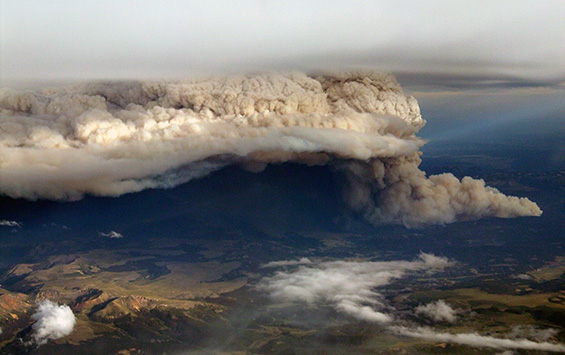
A large and intense wildfire near Durango, CO. Photo credit: Luis Rosa, NWS forecaster.
The aerosols in the pyroCb, including carbon, are more efficient at absorbing solar energy than water vapor. They also remain high in the atmosphere for long periods of time, traveling far from the PyroCb point of origin. The effects of this matter in the atmosphere have yet to be determined. As climate scientists are able to gather more information about pyroCbs, they will start to use that data in their models.
Bryan Baum, SSEC Senior Scientist, says, “Awareness of these unique clouds has been growing over the past decade. It’s a really intriguing situation because there is a global community that is beginning to become aware of the phenomenon, but there was no central person to gather, collate, and distribute all the feeds.”
To meet this need, Scott Bachmeier, a research meteorologist for the Cooperative Institute for Meteorological Satellite Studies (CIMSS), and the chief architect of the CIMSS Satellite Blog, has created another blog to highlight pyroCb events around the globe.
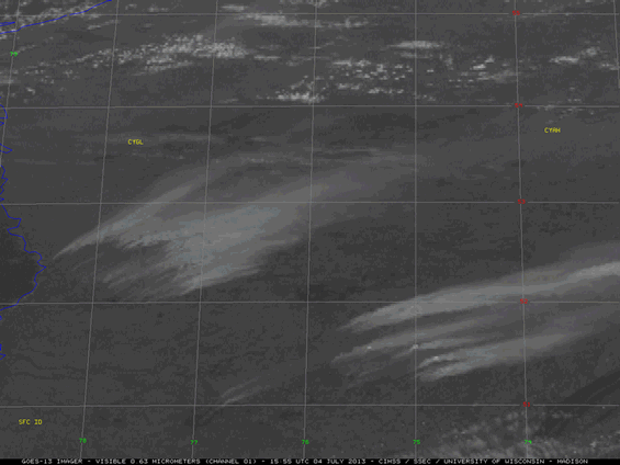
1-km resolution GOES-13 0.63 µm visible channel images shows several dense plumes of smoke, along with the development of a pyrocumulonimbus (pyroCb) cloud after about 21:55 UTC on 04 July 2013. A well-defined pyroCb anvil casting a shadow on the smoke layer below is seen at 23:02 UTC.
Because of the volume of satellite imagery collected by SSEC’s Data Center on a daily basis, Bachmeier is finding himself in a unique position to catalog pyroCb cloud events with more detail than has been possible in the past.
“I think this will be a real eye-opener,” Bachmeier continues. “Before now we had no idea how often these events occur. Or how big they are and how long they last. This doesn’t just happen one or two or three times annually. Right now these are happening every week. Is that just this year’s drought, or are we seeing something we haven’t really noticed before, but that has always been here?”
This summer, during the northern hemisphere’s wildfire season, Bachmeier is gathering satellite data from all over the world and creating a library of global pyroCb events. His first posting on the pyroCb blog documents a fire near Lake Baikal, on the Russian-Mongolian border. He has collected recent images of pyroCbs in connection with raging fires in New Mexico, Colorado, Arizona, and Canada.
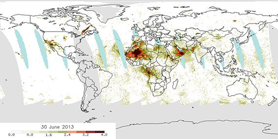
The 30 June 2013 Ozone Mapping Profiler Sheet (on Suomi NPP) Aerosol Index (AI) product taken at the time of the Colorado wildfires. Note that there are also very high values over Quebec from pyroCbs burning there. The product also shows a distinct plume of high aerosol index northwest of Lake Baikal, on the border of Russia and Mongolia. The AI product indicates a high-level absorbing aerosol, and any value over about 4 or 5 generally indicates the presence of a major fire event in the mid-latitudes.
Bachmeier hopes that with the information gathered into one place, scientists can begin to get an idea of how wide spread the events are, how often they happen, and what the short and long-term effects are. He credits the blog with opening up a new stream of information for climate research.
“With the advent of the blog,” he says, “it is much easier to put images and data out there. Papers will be written and published, of course, but that will take time. In a blog you can have the images up almost immediately. Researchers can see what’s happening as it evolves.”
Bachmeier continues to keep a close watch on satellite data from all over the world. The northern hemisphere is suffering droughts and high temperatures – perfect conditions for wildfires. And in a few months it will be summer in Australia, which typically has many fires per year. He is sure he will continue to fill his catalog of pyroCb events.
“After we have a year or so of a tally, we will be able to see how this year compared to the year before, or the year before that. Maybe then we go back and look at years where there were more of them. Is this year an anomaly or is it just average? How often does it happen? It’s scary, but I think this year is probably average.”