Monthly News Summary – November 2001
New Views
by Terri Gregory, SSEC Public Information Coordinator
November 2001
This issue of In the News primarily covers September and October 2001. Please feel free to use images, with credit to the University of Wisconsin–Madison’s Space Science and Engineering Center, (UW–Madison/SSEC), except where otherwise noted.
IceCube funding—UW–Madison announced on November 6 that a Congressional committee has approved funding for the first phase of IceCube, a “next-generation subatomic particle telescope designed to be implanted deep in ice in the South Pole.” $15 million was included in a fiscal year 2002 Veterans Administration-Housing and Urban Development appropriations bill that also provides funding for the National Science Foundation, which administers all U.S. research projects in Antarctica. The bill cleared a congressional conference committee, and, according to UW–Madison, is expected to win approval from the full U.S. House of Representatives, Senate and President George Bush. UW–Madison leads the international collaboration of 20 institutions, which includes UW–River Falls, and two historically black institutions, Clark University of Atlanta and Southern University. SSEC administers the project.
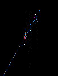 |
Simulated detection of muon-neutrinos by the Antarctic Muon And Neutrino Detector Array (AMANDA), a prototype for the IceCube neutrino observatory. Muon-neutrinos are shown interacting with a proton in the ice and produce a muon traveling in nearly the same direction as the neutrino. A blue light called Cherenkov light is emitted along the muon’s kilometer-long trajectory and is detected by strings of photomultiplier tubes deployed deep below the surface. |
Science magazine noted in September that IceCube was approved by the National Science Board. Board approval does not guarantee funding but indicates the scientific value of a project. On November 6, Wisconsin Public Radio broke the news, noting that the approved amount was 1/10th what was needed to complete the project. In the November 7 Milwaukee Journal Sentinel, U.S. Representatives David Obey and Tammy Baldwin (D, WI) were credited for their part in conference approval of the project. In the Wisconsin State Journal, Baldwin is quoted saying, “Research such as this puts our great university at the forefront of today’s scientific discoveries… .” Madison’s Capital Times paper noted that Robert Morse, director of AMANDA, IceCube forerunner, said that project funding means new jobs for Wisconsin. Bush administration personnel would not comment on whether the president would veto the project.
Satellite data browser—A new browser for geostationary satellite data is available on SSEC’s Real-Time Data page. It currently presents images from five different geostationary satellites—two U.S. (GOES-East and West), two European (MET-5 and 7) and the Japanese GMS—in a variety of resolutions, geographic coverage and wavelengths. You can also choose to save an image smaller (as a jpeg file) or in higher quality (as a larger gif). Individual images are all shown in fashionable black and white, while color enhancements are available for the animated infrared imagery. Stay tuned for additional features as they are developed.
Ground station for Central America—Two years after Hurricane Mitch devastated several Central American countries, a system to acquire weather satellite data for the region was formally inaugurated in Costa Rica. On July 26, officials from both Costa Rica and the U.S. attended the event. Guillermo Vega, ground station manager, expressed appreciation to James Ellickson, NOAA program manager for the project, and Robert Oehlkers, SSEC technical manager. Vega gave Oehlkers and Ellickson credit for “getting this project going.” He also credited SSEC and its Cooperative Institute for Meteorological Satellite Studies “for all the collaboration as an excellent partner in this important venture that culminated with the installation of the GOES satellite ground station and having RAMSDIS capability.” Colorado’s Cooperative Institute for Research in the Atmosphere and NOAA collaborated with SSEC to provide Central America with a system to provide current weather information which will aid in preparing for future disasters.
Snow in North Dakota—More than a foot of snow fell over the eastern portion of North Dakota from a strong early fall snow storm on Wednesday, October 24. On board NASA’s Terra earth science satellite, the Moderate-resolution Imaging Spectroradiometer (MODIS) observed the cities of Fargo and Grand Forks, evident in an October 26 image as gridded lighter blocks along the North Dakota/Minnesota border.
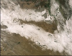 |
MODIS 250 m resolution image of snow bands laid down across Southern Saskatchewan and Manitoba in Canada and North Dakota in the United States. The image was acquired on 26 October 2001 via direct broadcast at SSEC. |
The snow band in Canada fell from a storm earlier in the week. Various darker land features are evident within the snow bands indicating different vegetation, different elevation and/or different land use strategies from the surrounding area. The image, provided by SSEC MODIS researchers Liam Gumley and Kathleen Strabala, appeared on NASA’s Earth Observatory Web site on October 27, with more details about the storm that brought the snow.
Twin Towers attack—As stunned as all Americans, SSEC did what it could to put the tragedy of September 11 in perspective. The smoke plume rising from the Manhattan attack could be seen from space, even from as far away as geostationary orbit (about 22,300 miles). WAWS-TV in Jacksonville, Florida used a satellite image during a broadcast “to further illustrate the devastation this abhorrent tragedy has caused.” (Jake McCain, WAWS Art Director/Webmaster) The images were also used in UW–Madison’s Why?Files and Wisconsin Week, the campus newspaper, in print and on line, in an article on reactions to the tragedy. A MODIS image of the smoke plume, received via direct broadcast at SSEC, was used in false color on NASA’s Earth Observatory Web site and briefly on NASA’s home page. The latter was graphically enhanced and combined by Fritz Hasler, Goddard Space Flight Center, with one by Jim Dodge. Hasler’s enhancement was used on CNN online and used by NBC-TV National News.
On the Net
For More Information
Professor Suomi honored—The Earth Observatory Web site features Verner Suomi in the series “On the Shoulders of Giants.” They use a piece by Russell Hall, formerly of SSEC, written for a tribute booklet to Professor Suomi, known as father of weather satellites and SSEC’s founder and first director. If you’d like this booklet on the life of Professor Suomi, write to V.E.Suomi booklet, 1225 W. Dayton St., Madison, WI 53706. Besides the Hall piece, it includes lists of awards and publications, and many personal stories by people who knew him.
University of Paris—The Institute of Geography’s Web site uses SSEC’s global composite image in a Directory of Meteorological Satellite Applications prepared by EUMETSAT, the European Organization for Meteorological Satellites. The composite introduces the section, “The Global Network of Geostationary Meteorological Satellites.” While broad in scope and potentially quite useful, the directory seems to be out of date. Individual pages are not dated, nor is the directory itself.
Weather for gardeners—“A Garden Place” lists SSEC and CIMSS Web sites in its rather amazing list of weather-related sites. “Place” is devoted to everything for the gardener and anything else that site owner Glenn Bronner likes.
Silent Sports magazine used Scott Bachmeier’s list of cross country ski-related weather links in their online column, News and Results. They call it a “fine weather page with some great national color weather maps and snowfall maps for the wintertime.” They even give SSEC a credit. Silent Sports is a monthly Midwest regional magazine about cross country skiing, bicycling, running, paddling, multisports.
Broadcast
Weather Guys—Steve Ackerman and Jonathan Martin appeared on WHA Radio on September 24 and October 29. The latter show focused on weather phenomena, especially the aurora borealis, which can be seen on nights after solar storms. Callers also asked what causes wind gusts. As always, the programs were lively and informative. The Weather Guys next appear on November 26 at 11:45 a.m.
The American Museum of Natural History interviewed Scott Bachmeier for a documentary on the July 4, 1999 derecho event. This storm produced widespread forest damage across the Boundary Waters Canoe Area Wilderness region of Minnesota and western Ontario. The story will be featured in the AMNH “Earth Bulletin” series and will include video of GOES-8 imagery from the derecho event.
In Print
The Coldest March—Wisconsin Week notes that data from UW–Madison’s Automatic Weather Stations is used in Susan Solomon’s new book The Coldest March: Scott’s Fatal Antarctic Expedition, about the Scott expedition, published by Yale University Press. Solomon, a senior scientist in NOAA’s Aeronomy Laboratory in Boulder, Colorado uses data collected since the 1980s from a network of UW–Madison weather stations throughout Antarctica to show that the 1911–1912 season was abnormally severe and that no one would have expected the weather that Scott encountered. Charles Stearns and members of his group are acknowledged, Stearns especially for his pioneering efforts in establishing the stations across Antarctica and selflessly making the data freely available. Solomon notes that although the stations are intended to operate automatically, Stearns’ group installs and maintains them. She also uses photos of the Automatic Weather Stations being installed and of iceberg B-15.
Stearns appeared with Solomon at a National Press event on September 10 where he talked about his weather stations and the process of supplying data on Antarctica to everyone who needs it.
AMRC in print—National Geographic magazine will publish an article on their visit to the B-15 icebergs in the December issue. Matthew Lazzara of the Antarctic Meteorological Research Center provided background information, especially for a detailed map of iceberg movement. Marcello Manzoni uses an Antarctic composite in his book, La Natura dell’Antartide (The Nature of Antarctica).
Spin-scan camera cited—William Kininmonth of the World Meteorological Organization is publishing a book on the climate of the 20th century. It will include scientific and technological developments and will reference Professor Verner Suomi’s spin-scan camera which made it possible to see the earth from geostationary orbit. Kininmonth is Acting Chief of WMO’s World Climate Data Division.
The U.S. Weather Research Program has used an image prepared by the Tropical Cyclones group in a brochure. The image appeared on a poster by Chris Velden and Dave Stettner for the GOES Rapid-Scan Winds Experiment, GWINDEX. It makes use of GOES observations taken every 7.5 minutes. Ordinarily, the GOES satellite is programmed to take images of the earth every 30 to 60 minutes, and therefore capturing more of the earth. In “rapid-scan” mode, the satellite takes images of a small geographic area every few minutes. This enables a more complete description of the wind environment at a particular moment for a particular place and is very useful in forecasting severe weather.
“Parameterization of shortwave ice cloud optical properties for various particle habits” has been accepted (subject to minor revision) for publication in the Journal of Geophysical Research-Atmospheres. Authors are Jeff Key (ASPT), P. Yang (Texas A&M University), Bryan Baum (NASA’s Langley Research Center, stationed at SSEC), and Shaima Nasiri (SSEC/CIMSS). It presents a new parameterization of the shortwave optical properties of various ice particle “habits” including hollow and solid columns, aggregates, plates, bullet rosettes, and dendrites. The effects of ice cloud particle shapes and sizes on satellite observations can now be simulated.
“Validation and use of GOES sounder moisture information” has been accepted for publication by the journal, Weather and Forecasting. The validations were made using collocated radiosondes, a microwave radiometer, parallel runs of the regional Eta model, and forecaster responses. Authors are Timothy Schmit, Paul Menzel, James Jung, and Gary Wade of NOAA; Wayne Feltz and James Nelson of SSEC/CIMSS; and Andrew Noel and James Heil of the National Weather Service. The work should be published in about April.
Measurement consistency—Grant Petty’s “Automated computation and consistency checking of physical dimensions and units in scientific programs” presents a new method for converting and checking consistency of measurement units utilized in calculations. Published in Software—Practice and Experience, vol. 31, pp. 1067-1076, Petty’s piece explains that no support is currently available in standard programming languages for ensuring consistency in the units assumed, nor for automatically converting between systems of units, such as metric and English. Petty’s software, written in Fortran, the programming language that engineers and researchers in the physical sciences use most, provides a simple mechanism for adding this support to existing scientific software. He notes that although ensuring consistency among units would add some computational overhead to existing software libraries, his software can potentially “reduce the risk of expensive and/or embarrassing errors, particularly where mixed systems of units are employed,” as in the recent loss of NASA’s $125 million Mars Climate Orbiter.
IDL Guide—Wisconsin Week lists Liam Gumley’s book, Practical IDL Programming, in the Awards and Honors column (September 12).