Monthly News Summary – September 2001
New Satellite, New Images
by Terri Gregory, SSEC Public Information Coordinator
September 2001
This issue of In the News covers August 2001. Please feel free to use images, with credit to the Space Science and Engineering Center, University of Wisconsin–Madison (SSEC/UW–Madison), except where otherwise noted.
New GOES—The latest in the series of GOES weather satellites was launched July 23. The satellite, now called GOES-12, will, according to NASA, “monitor hurricanes, severe thunderstorms, flash floods and other severe weather.” It is also the first U.S. geostationary weather satellite equipped with a “Solar X-ray Imager” that will detect storms on the sun. The satellite achieved its orbit on August 12 and after a preliminary checkout period, SSEC, the national archive for U.S. geostationary weather data, was first to capture and make available its first whole earth image, on August 17. The image is offered for public viewing on SSEC’s Web home page.
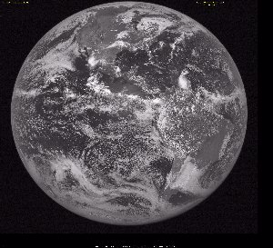 |
The first GOES-12 visible image was released by SSEC on August 12, 2001. |
Almost overshadowed by the solar imager is an improved GOES-12 earth imager. A team of NOAA and SSEC researchers has written a paper describing its capability. To be published in the National Weather Association Digest, “Introducing the GOES-M Imager” explains new and existing capabilities. (A satellite’s letter designation changes to a number when it has achieved its final orbit and been passed from NASA to NOAA.) According to Tim Schmit (NOAA, at SSEC), the imager “will improve several satellite products, such as cloud properties and satellite-derived wind fields.” The team also notes that adding capabilities will decrease others that can be made up from polar-orbiting satellites.
MODIS images—A new Web site has been established to serve images from SSEC’s Terra MODIS direct broadcast antenna. Color and black and white “quick looks” over various regions of the continental U.S. are posted within about 90 minutes of the end of each Terra contact. Informational links are located at the bottom of the page. In the summer of 2000, SSEC became a direct broadcast site for data from the MODIS instrument on NASA’s Terra satellite. The satellite, first in a series of earth science satellites, became operational in spring of 2000. MODIS, the Moderate resolution Imaging Spectroradiometer, is one of five specialized science instruments on Terra. SSEC researchers helped develop the prototype on which MODIS is based and are on the science team to develop and provide MODIS atmospheric products.
Weather Research
Barry’s Winds—Working with NOAA’s Hurricane Research Division, CIMSS’ Tropical Cyclones group derived experimental wind measurements during Tropical Storm Barry. To derive the winds, the group used the 3.9 micron short-wave infrared channel on the Geostationary Operational Environmental Satellite (GOES-8). Using stretching and enhancement techniques, the CIMSS automated tracking software was tuned to track low-level features evident in the circulation of Barry. The National Hurricane Center (NHC) acknowledged this product as an impressive improvement that will help aid their wind analyses and advisories.
 |
Low-level wind measurements give definition to the circulation of Tropical Storm Barry. |
GOES Imager—Using data from the GOES Imager, Tony Schreiner (CIMSS) and Tim Schmit (NOAA/ASPT) produced Clear Sky Brightness Temperatures (CSBT) for use in numerical weather prediction. To calculate CSBT, the researchers took advantage of channels on the Imager instrument that measure both visible light and infrared (temperature) wavelengths. A hemispheric cloud mask was generated as a byproduct. Average CSBT will be produced for a box, 50 kilometers on a side, using the technique needed to generate this cloud mask, and will be made available for numerical weather prediction models in both the United States and Europe.
 |
The sample cloud mask image is based on GOES Imager data at “full” resolution (nominally 4 km at the satellite sub-point). Light gray shows cloud. Dark areas are clear. |
Satellite Instrument Development—Both the ABS (Advanced Baseline Sounder) and GIFTS (Geosynchronous Imaging Fourier Transform Spectrometer) will meet National Weather Service requirements. This good (and expected) news came from a meeting held on July 31 in Madison to discuss ABS requirements. Approximately 20 scientists and engineers represented the NWS, NESDIS (National Environmental Satellite, Data, and Information Service), NASA and Massachusetts Institute of Technology’s Lincoln Lab. A two waveband ABS (referred to as the ABS prime) was proposed which will give improved moisture retrievals compared to a three waveband instrument. CIMSS and SSEC are on development teams for both instruments; the ABS is being developed for the National Oceanic and Atmospheric Administration; the GIFTS is being developed for NASA, with implications for NOAA weather forecasting operations.
GOES Wildfire ABBA—Over the past year, D. Westphal at the Naval Research Laboratory in Monterey, California has been assimilating half-hourly fire products into the Navy Aerosol Analysis and Prediction System (NAAPS). Westphal is using products generated by the Geostationary Operational Environmental Satellite (GOES) Wildfire Automated Biomass Burning Algorithm (ABBA) to analyze and predict aerosol extent, loading, and transport regimes. For the past week, the NAAPS has successfully documented the transport of smoke associated with wildfires burning in the western U.S. On August 18, the NAAPS analyzed a large smoke pall that extended north into Canada and south over the plains of Montana. Elaine Prins (NOAA/ASPT) and Chris Schmidt (CIMSS) are collaborating with the Navy in this program, funded by NASA under the Earth Systems Enterprise modeling and data analysis research program. The animation online shows fires burning in the western U.S. on August 17, 2001. Fires burning in the state of Washington produced large smoke palls that extended into Canada and Montana on subsequent days.
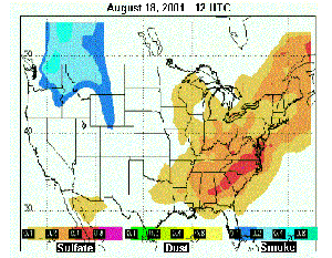 |
The NAAPS model output documents a large smoke pall (in shades of blue) on August 18, 2001 associated with wildfire activity in the state of Washington. The NAAPS model uses the Wildfire ABBA product as input to determine source locations and emissions. |
Streamer— Jeff Key (NOAA/ASPT, at SSEC) has released a beta version of the radiative transfer model Streamer. Streamer can be used for satellite radiance simulations as well as the calculation of radiative fluxes and heating rates. It is currently used by research scientists in more than 30 countries and in a variety of university courses. Recent additions include increased control over cloud characteristics, the ability to utilize surface bidirectional reflectance functions, a variety of ice cloud particle shapes, and an interactive user interface.
NOAA will publish a Technical Report that summarizes some of the findings during the GOES-11 check-out period. The Geostationary Operational Environmental Satellite-11 (GOES-11) Science Test Report: GOES-11 Imager and Sounder Radiance and Product Validations is edited by J. Daniels and T. Schmit. Schmit is a member of NOAA’s Advanced Satellite Products Team, stationed at SSEC.
Broadcast
CLAMS—The Weather Channel ran a short video of the CLAMS field campaign to run throughout the day on August 1. SSEC participated in CLAMS, the Chesapeake Lighthouse and Aircraft Measurements for Satellites, observing with the Scanning-HIS, and with calibration of the NAST-I, an instrument developed by NASA’s Langley Research Center.
WHA Weather Shows—Right at the tail end of July’s blistering heat wave, Steve Ackerman appeared on Tom Clark’s WHA Radio early morning call-in show. For the 6-7 a.m. hour on August 9, Ackerman, director of the Cooperative Institute for Meteorological Satellite Studies and a professor in UW–Madison’s Department of Atmospheric and Oceanic Sciences (AOS), assured people that the heat wave would end and answered a host of weather-related questions.
On August 27, Weather Guys Steve Ackerman and Jonathan Martin (AOS professor) appeared in their regular monthly spot on Larry Meiller’s WHA call-in show. They received many good questions from their intelligent mostly Wisconsin audience: Why don’t fast winds in a slow-moving storm overrun themselves? (The Guys said, they do, eventually.) What’s the effect of a long period of western wildfires on Wisconsin’s weather and climate-red sunsets, but no studies have shown any other effects. About double rainbows, why are the colors reversed in the bottom rainbow? Optics expert Ackerman said that the reflection was doubled, indeed, a mirror image of the first rainbow reflecting onto water droplets. The Weather Guys and host Meiller encourage calls about personal weather observations. This month’s included rolling thunder-probably from a line of “continuously firing” thunderstorms; clouds forming and dissipating (over the mountains); and ball lightning with a vivid description—“flakes of fire coming off it.” Listen to the Weather Guys next on September 24 at 11:45 on 970 AM or 90+ FM or on the Internet.
In Print
Coldest March— The New York Times “Science Times” section (Tuesday, August 28) features work based on data collected by Automatic Weather Stations. Charles Stearns (emeritus professor of UW–Madison’s Department of Atmospheric and Oceanic Sciences and SSEC senior scientist) pioneered the use of these weather stations (AWS) in Antarctica. Susan Solomon (NOAA senior scientist) has written a book on the journey of Robert Scott and his team to the South Pole in one of the coldest Antarctic winters recorded. In 1986, Solomon led a research team to investigate the Antarctic ozone hole and became intrigued with the Scott story. Since then, she has collaborated with Chuck Stearns and other UW–Madison researchers in using the data to compare current and past Antarctic weather conditions. While some disagree with her conclusions, Solomon believes that, based on the AWS data, Scott and his team succumbed to abnormally cold temperatures. Solomon’s book,The Coldest March, is about to be released by Yale University Press. Automatic weather station data is featured in the Coldest March Web site. Chuck Stearns will accompany Susan Solomon and other colleagues to a National Press Club event on September 10 set up by the National Science Foundation to discuss the science behind the book and the work of the U.S. Antarctic program.
On the Net
Ars Electronica—Daniel Sandin, who directs the Electronic Visualization Laboratory at the University of Illinois at Chicago, will use water vapor imagery from SSEC’s Web site to map onto a sphere. Sandin and his students are leaders in the forthcoming Ars Electronica Festival 2001, being held in Linz, Austria in early September. For the festival, Sandin’s EVL will provide a collection of eleven virtual worlds entitled, “EVL: Alive on the Grid.” The water vapor imagery will be used in the event, “Looking for Water.”
The Edmonton Space & Science Centre (ESSC) in Edmonton, Alberta, Canada will use a colored satellite image in an educational exhibit on astronomy and space science. The image, produced at SSEC from geostationary weather satellite visible and infrared data, was found on a Web site where it is used to illustrate infrared capabilities. Scroll down to “What does the Infrared show us?”
Tropical Storms—Students at Rongotai College in Wellington, New Zealand will use some images from the CIMSS Tropical Cyclone Web page in a Web site design competition. They plan to enter their own Tropical Cyclone page and will credit CIMSS.
Outreach
Recipients of the 2001 Verner Suomi scholarship were listed in WisconsinWeek, August 29, the campus newspaper’s first issue of the new semester. Winners competed for the $1000 grant, recognizing “achievement in the physical sciences.” They will all attend a UW System campus, majoring in the physical sciecnes, including atmospheric sciences.
In the Wings
AMS— The 11th Conference on Satellite Meteorology and Oceanography will be held in Madison, Wisconsin from 15-18 October at the Monona Terrace Convention and Community Center. As of August 10, 30% of the papers submitted (80 contributions) were from CIMSS and ASPT scientists. To learn more about those and other topics being presented at the conference, go to the AMS Web site and click on “Conferences, Meetings, and Symposia” in small type at the bottom of the main frame. Satellite Meteorology is found in AMS Upcoming Meetings (mid-page). The Space Science and Engineering Center, UW-Madison, is the city host for the American Meteorological Society, who is responsible for all online documents and Web page.
Some topics covered by SSEC, CIMSS and ASPT scientists (and co-authors from around the world) are fire detection and fire products, the assimilation of geostationary satellite moisture data, the use of sounder data for nowcasting, channel selection on the Advanced Baseline Imager, GOES visible calibration, retrieval simulations for the high-spectral resolution Advanced Baseline Sounder, satellite intercomparisons, cloud product generation from the GOES-M imager, single field-of-view GOES sounder retrievals, sounder cloud product validations, assimilation of sounder clouds into the Eta system and the evaluation of several years of sounder data. Papers also cover a polar winds data set, the effect of clouds on the surface radiation budget of Antarctica, the impacts and remedies of losing the 12 micron channel from GOES-M and beyond. Many other topics are covered.
A public presentation will also be given. Frederick Hasler, of NASA’s Goddard Space Flight Center, will bring his Electronic Theater, a dramatic visual presentation of Earth Science data sets, to Monona Terrace Convention Center for one evening during the conference. Also, several presentations are scheduled for school children during two days.