Monthly News Summary – August 2001
GOES Shows Wildfires, Tornadoes
by Terri Gregory, SSEC Public Information Coordinator
August 2001
This issue of In the News covers July 2001. Please feel free to use images, with credit to the Space Science and Engineering Center, University of Wisconsin–Madison (SSEC/UW–Madison), except where otherwise noted.
Thirty mile fire—James Neff of the Seattle Timesused Wildfire ABBA products and descriptions as background for an article documenting the “Thirty Mile Fire” in north central Washington. CIMSS researchers Chris Schmidt and Scott Bachmeier and NOAA’s Elaine Prins provided imagery and data produced using the Geostationary Operational Environmental Satellite (GOES) Wildfire Automated Biomass Burning Algorithm (ABBA), a NOAA-CIMSS satellite product. The imagery shows how, on the afternoon of July 10, 2001, the 100 acre fire “rapidly grew into a 2500 acre conflagration that resulted in the deaths of four firefighters.” The GOES Wildfire ABBA showed a rapid intensification of the wildfire between 4:30 and 5:30 PDT (23:30 UTC, July 10–00:30 UTC, July 11).
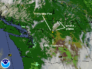 |
This GOES Wildfire ABBA animation documents the rapid intensification of the”Thirty Mile Fire” in north central Washington during the late afternoon of July 10. Several other fires can also be seen in Washington and southern Canada. |
The “Why Files,” a University of Wisconsin–Madison on-line publication, featured the Wildfire ABBA observations as a Cool Science Image. The Why Files is a resource for teachers and students and covers issues of science, health, environment and technology from a unique perspective. It covers science at all institutions that engage in scientific exploration and discovery and explains science in exciting and understandable terms.
The Geospatial Solutions magazine featured the GOES Wildfire ABBA in its July issue. A sidebar titled “GOES Burns Bright” described the history and current uses of the application. It focused on the successful identification of the San Diego Viejas fire (January 3, 2001) by the GOES-10 Wildfire ABBA within minutes of ignition. The sidebar was included as part of an extended article titled “Blazing Ahead: Mobile GIS for Emergency Management” discussing the use of Geographic Information Systems to combat the Viejas fire. The fire was apparently started by a discarded cigarette and rapidly engulfed thousands of acres that took 6 days and 2000 firefighters to contain.
The National Weather Services forecast office in Wilmington, North Carolina asked for weather satellite imagery depicting a tornado event over Myrtle Beach, South Carolina on July 6, 2001. CIMSS researcher Scott Bachmeier posted GOES imagery on the GOES Gallery. Visible imagery indicated that atmospheric conditions close to the earth may have played a role in the development and intensification of the severe storm development, and an “enhanced-v” cloud-top signature was evident in infrared data 20 minutes before the tornado. GOES-8 sounder information (called Derived Product Imagery, or DPI) showed high values of moisture and instability before the storm.
Prestorm Analysis—Scientists have analyzed the period before the onset of a large tornado outbreak on May 3, 1999 in Oklahoma and Kansas. Bob Rabin of NOAA’s National Severe Storms Laboratory and CIMSS collaborated with D. Bikos and B. Motta of Colorado’s Cooperative Institute for Research in the Atmosphere to analyze water vapor wind measurements from GOES-10. The analysis was performed at 30-minute intervals and includes mesoscale detail not present in operational analyses such as that from the U.S. Eta model. It shows that an upper level wind maximum was first detected in southwest New Mexico more than 10 hours before storm formation, associated with a cirrus shield as it expands northeastward to the Texas panhandle 6 hours later. The jet maximum and associated upper level divergence that developed over Oklahoma likely played a role in the initiation of the storms by late afternoon.
Validating Satellite Measurements
For More Information
University Communications released Proteus news on June 28, in preparation for the research aircraft’s Madison visit to retrieve a NASA instrument, at SSEC for testing. Representatives of four media outlets stood in the heat for two hours awaiting the plane’s arrival on July 9. Television channel 15 broadcast short pieces on evening and morning news programs, and featured SSEC Director Hank Revercomb explaining the scientific purpose of the visit. Channel 27 also covered the event. Clearly the plane enthralled onlookers with its dragonfly resemblance. Terrific pictures were published in the Milwaukee Journal Sentinel and the Wisconsin State Journal who explained that the Proteus was on its way to the Virginia coast for the field program, Chesapeake Lighthouse and Aircraft Measurements for Satellites.
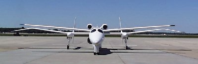 |
The Proteus aircraft on the Truax Field tarmac—Wisconsin Air National Guard personnel will wheel it into the waiting hangar. |
The Proteus fetched the National Polar-orbiting Operational Environmental Satellite System (NPOESS) Airborne Sounder Testbed-Interferometer. NAST-I, designed by NASA’s Langley Research Center, is a flying testbed for future weather satellite instruments. Its technology is based on that of instruments developed by SSEC scientists, especially Bill Smith, now chief scientist at Langley, and Hank Revercomb, SSEC director. The NAST-I was being tested with SSEC instruments.
SSEC researchers took their own interferometer-based instruments to Virginia to participate in CLAMS. The aircraft-borne Scanning-HIS (High-resolution Interferometer Sounder) and the Atmospheric Emitted Radiance Interferometer accompanied the NAST-I to support the larger CLAMS objectives. The interferometer-based instruments measure infrared radiances in very fine detail. “During CLAMS, the Scanning-HIS measured upwelling radiances from the high altitude NASA ER-2 research aircraft, while the ground-based AERI was stationed at NASA’s Wallops Flight Facility and measured downwelling radiances at the surface,” said SSEC researcher Dave Tobin. The detailed atmospheric profiles obtained from these interferometric measurements will help validate observations from satellites in NASA’s Earth Observing System. Researchers in CLAMS also are studying how aerosols act in an oceanic environment and how they affect the radiation that the satellites measure. A field program of this scope also allows the instrument teams to compare their measurements, to ensure accuracy. They were able to carry on the calibration tests begun at SSEC in Madison with the NAST-I, adding air-borne measurements to those already made in the lab and from the ground. Making these detailed tests and measurements in different environments enables the teams to better learn how their instruments will operate on a satellite.
The Weather Channel aired the CLAMS story on August 1 and it was printed in the Wallops Island facility newsletter.
Weather Research
Fires and Carbon Monoxide—CIMSS and NOAA scientists analyzed fire observations made by the current GOES with carbon monoxide measurements by an instrument on NASA’s Terra satellite. Kate Goodstein, Scott Bachmeier and Joleen Feltz (CIMSS) and Elaine Prins (NOAA, at SSEC) intercompared carbon monoxide distributions taken with the MOPITT (Measurements Of Pollution In The Troposphere) with fire observations made using the GOES ABBA. In South America, fire observations on September 7, 2000 were shown with MOPITT-derived carbon monoxide for the same date. Increased carbon monoxide concentrations were observed downwind of enhanced burning.
GOES Wildfire ABBA observations of wildfires in Idaho and Montana (August 22-27, 2000) were compared with a composite MOPITT carbon monoxide image for the same time period. During the entire week, smoke plumes observed in the GOES visible imagery and in 700 and 500 mb streamline analyses document the transport of emissions into the region of enhanced carbon monoxide.
Satellite Instrument Development—For MIT/Lincoln Labs, CIMSS researcher Jun Li selected a preliminary set of optimal channels for the Advanced Baseline Sounder (ABS). Out of 2000 possible instrument channels, Jun selected almost half as being most useful for scientific applications, such as the physical retrieval algorithm. Jun said that the algorithmic process that subtracts (retrieves) atmospheric information is time consuming. A set of optimal channels will significantly improve real-time data processing efficiency while maintaining retrieval accuracy. The ABS will replace the current sounding instrument on the next generation GOES. According to Jun, “The ABS can dramatically improve the accuracy of temperature and moisture products which will meet the National Weather Service requirement for future weather forecasts.”
Geary Callan (NOAA/ASPT) and Mat Gunshor (CIMSS) successfully tested intercalibration code for a NOAA satellite instrument. The code converts raw sensor counts to radiances for all spectral channels on the High Resolution Infrared Radiation Sounder (HIRS) on satellites in the National Oceanic and Atmospheric Administration’s polar-orbiting series. The intercalibration code facilitates comparisons between satellites.
In Print
The Journal of Geophysical Research-Atmospheres published “Estimating the cloudy sky albedo of sea ice and snow from space” on June 27, 2001. The paper is co-authored by Jeff Key (NOAA), X. Wang (CIMSS), J. Stroeve and C. Fowler (University of Colorado) and examines the theoretical and empirical differences between clear and cloudy surface albedo. The paper also presents a procedure for estimating the cloudy sky albedo of snow and ice surfaces using the Advanced Very High Resolution Radiometer.
A version of John Fauber’s Milwaukee Journal Sentinel article on satellite imagery appeared in the Montreal Gazette on June 9. Individual experiences are emphasized as they are illustrated in satellite imagery. SSEC’s large weather satellite data archive is noted.
Broadcast
Weather Guys Steve Ackerman and Jonathan Martin appeared on WHA on July 23, breaking from their regular last Monday gig. Callers asked good questions on global warming and global and regional change. Several of those concerned lake and water-table levels. The Guys opined that a good snowy winter, like North Dakota’s, would help to get water levels back up. They received questions on air composition and sky color (Arizona’s really is bluer than Wisconsin’s), and were stumped by a question about bubbles on puddles. Former Wisconsin State Climatologist Pamela Knox called in from Georgia, stating that bigger raindrops made bubbles. Listen to the Weather Guys next on August 27 at 11:45 on 970 AM or 90+ FM or on the Internet.
On the Net
SGI featured several Vis5D images in a lead story on July 10. SGI computers often are used in the field of weather and climate research. The software application often chosen to depict complex climate and weather concepts and events is Vis5D, freely available on the Web.
A University of Paris Web site uses an SSEC global composite in “The Global Network of Geostationary Meteorological Satellites.” SSEC is prominently credited.
Didier SVT, a French textbook publisher, will link to SSEC’s real-time data pages in their online science series. Examples are open to the public, but our images are on subscriber-only pages, accessible to French educators.
In the Wings
IceCube, the proposed next stage of AMANDA, the Antarctic Muon and Neutrino Detector Array, is a step closer to reality. FYI, the American Institute of Physics Bulletin of Science Policy News, number 98, July 27, 2001, features the legislative appropriations reports on NSF. Both House and Senate Appropriations Committees reports endorse IceCube, which, like AMANDA, would be a program in SSEC’s Antarctic Astronomy and Astrophysics Research Institute’s (A3RI). The House Report includes $15 million to initiate the project. The Senate Appropriations Committee “encourages the [NSF] to move forward” with the next phase of AMANDA, IceCube. The Senate Committee notes that the National Science Board approved the project. The committee also notes that, “Continued development is expected to lead to a new era in astronomy in which scientists will have unique opportunities to analyze some of the most distant and significant events in the formation and evolution of the universe.” Several more stages in the appropriations process remain, but this is an important first step.
Madison’s Murphy Entertainment is producing a series for the Discovery Channel called “Billion Dollar Disasters.” They talked with Chris Velden in CIMSS’ Tropical Cyclones group for a program on Hurricane Floyd.