Monthly News Summary – May 2001
Views of Mississippi Floods
by Terri Gregory, SSEC Public Information Coordinator
May 2001
This issue of In the News covers news received in April 2001. Please feel free to use images, with attribution to the Space Science and Engineering Center, University of Wisconsin–Madison (SSEC/UW–Madison), except where otherwise noted.
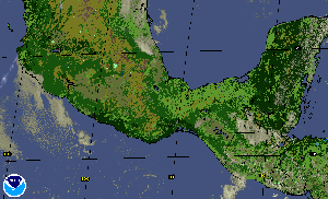
A series of images shows current flooding in the Mississippi and Wisconsin River valleys. The MODerate-resolution Imaging Spectroradiometer on NASA’s Terra satellite provided both those received at SSEC’s facility (April 18, 2001) and at NASA’s Goddard Space Flight Center (April 25, 2000). Liam Gumley, who coordinates SSEC’s direct broadcast reception, and Jacques Descloitres at Goddard, provided the imagery.
 |
This true-color image was acquired by MODIS at 12:15 p.m. local time April 18 as the waters crested. |
The images were used on CNN Live Today, on April 24, to illustrate the impact of flooding on the riverside communities.
Weather Research
Microwave hurricane sounding—Capt. Kurt Brueske, (U.S. Air Force, studying at UW–Madison) and Bob Aune (the NOAA group stationed at SSEC) found that data from the Advanced Microwave Sounding Unit (AMSU) instrument (on a NOAA polar-orbiting weather satellite) better resolved the thermal signature of Hurricane Floyd’s core than did a numerical model analysis from the National Centers for Environmental Prediction (NCEP) Eta model. Using the model analysis for 1200 UTC on September 14, 1999, and subtracting the Eta temperature from that retrieved by the AMSU instrument, a 5 degree Centigrade warm anomaly is found above the eye of Hurricane Floyd, and a cold anomaly is apparent at the surface. Capt. Brueske uses the AMSU instrument to assess the intensity and thermal structure of tropical storms.
Fire Detection— For the past three years, the Advanced Satellite Products Team (NOAA group at SSEC) has collaborated with M. Moreau (Environment Canada) to evaluate the capability of the GOES Automated Biomass Burning Algorithm (ABBA) for detecting wildfires in Canada’s Quebec province. M. Moreau recently completed a comparison of fire products from the GOES ABBA and the NOAA polar-orbiting satellite with ground-truth data collected during and after the 2000 fire season. When considering fires that burned more than 10 hectares, the ABBA was first to detect many of the fires in the restricted protection zone; NOAA-14 was first to detect 2 of the wildfires. Seventeen of the fires detected by the GOES ABBA were in remote locations and were not detected by Quebec’s forest fire detection and prevention agency.
 |
Of fires greater than 10 hectares in size, green stars indicate how many were initially detected by Quebec’s forest fire detection and prevention agency (SOPFEU), blue by NOAA-14, and red by the GOES Automated Biomass Burning Algorithm (ABBA). The GOES-8 ABBA was the first to detect many of the fires in the more remote areas. Fires labeled with a letter indicate fires that SOPFEU did not detect. Click on the image for a larger, captioned image. |
Fires in the Yucatan—Throughout March, the Geostationary Operational Environmental Satellite (GOES)-8 Wildfire Automated Biomass Burning Algorithm (ABBA) identified increased burning in the Yucatan peninsula associated with the region’s annual agricultural burning season. The daily cycle is clearly evident-burning begins at around 9:00 a.m., peaks in the early afternoon, and decreases by late afternoon. Near real-time animations of the composite Wildfire ABBA product for the southern Mexico region can be viewed on line.
 |
The diurnal cycle in agricultural burning in the Yucatan Peninsula is shown in the GOES Wildfire ABBA product from 14:45 to 23:45 UTC on April 12, 2001. Processed fire pixels are identified in red, saturated fire pixels are yellow, and cloud-contaminated fire pixels are in magenta. High, medium, and low possibility fire pixels are labeled in orange, navy, and light blue, respectively. |
University Communications
For More Information
OSSERoad Show—UW–Madison took its show “on the road” this spring, this time to Chicago’s Adler Planetarium. As noted in University Communications’ news release (April 12), the “three-year-old outreach campaign brings civic and educational programs to major cities in Wisconsin.” In 2001, for the first time the borders of the university extend into Chicago, where many university alumni dwell. Sanjay Limaye was one of several UW faculty and staff who spoke in late April on astronomical topics. Limaye spoke on “Weather in the Solar System” at the Adler on Tuesday; he and astronomy professors worked with students at Providence St. Mel School on Wednesday.AMANDA,
UW–Madison
Home Page
UW Newsmakers—[Scroll to March 26, 2001] UW–Madison’s AMANDA project was featured in the New York Times (03/26/01). According to Physics Professor Francis Halzen, the AMANDA detectors show a “sensitivity well beyond other instruments, and the neutrinos we’ve seen are of a higher energy than has been seen before.” A recent article in the journal, Nature, presents the technique which allows physicists to “trace high-energy neutrinos back to their place of origin.” Professor Robert Morse is AMANDA principal investigator; SSEC administers the project.
In Print
For More Information
V.ViewScott Bachmeier is The Capital Times’ “Public Worker” for April 16. Reporter Aaron Nathans stressed Bachmeier’s work with VISITView, a software program that allows forecasters with NOAA’s National Weather Service to manage several kinds of weather data, including satellite, at one time. Bachmeier, who is a researcher in SSEC’s Cooperative Institute for Meteorological Satellite Studies, works with Tom Whittaker, who developed the software, to integrate all the elements the forecasters need to consider when making a forecast. Both Bachmeier and Whittaker bring years of experience in atmospheric research; Whittaker was employed as a forecaster for the Weather Bureau, former name of the National Weather Service, before working for SSEC.
The National Geographic Society is hawking a new series of books, all with the theme of human exploration. The cover of Exploring the Solar System features several images of planets, including one of Neptune produced from Hubble Space Telescope and ground-based images by SSEC“s Larry Sromovsky and Pat Fry. Sromovsky and SSEC and NASA are credited in the promotional brochure.
Broadcast
For More InformationWORT-FM
Sanjay Limaye, SSEC’s Director of the Office of Space Science Education, appeared on WORT-FM Radio’s Thursday evening science show, hosted by Scott Delaruelle, on April 5. The two discussed the Galileo mission to Jupiter, including discoveries of Jovian moons.
On the Net
Great Lakes weather—About 5 years ago, Steve Ackerman and John Knox developed a Web site to mark the 20th anniversary of the sinking of the ore ship Edmund Fitzgerald. The site describes and analyzes weather conditions on Lake Superior at the time of the accident. Its 25th anniversary occurred in November 2000 and Web surfers beat a path to its virtual door. According to SSEC Web statistics for the first quarter of 2001, Google referred people 1064 times to the Web site (about 35 of those also had “lyrics” in the search line, so they were clearly not looking for the weather site.) Through Yahoo, Google referred another 144 people.
Honors
For More Information
Elaine Prins, a NOAA employee stationed at SSEC, has been named NOAA Employee of the Month. Nominating Elaine were her coworkers and acting team leader at the SSEC group, the Advanced Satellite Products Team within the National Environmental Satellite, Data, and Information Service’s Office of Research & Applications. Prins was nominated for her “considerable flexibility and commitment to NOAA by eagerly taking on additional responsibilities as Acting Team Leader” of her group in 1998. Prins is noted for her scientific leadership in the field of fire detection. According to NOAA’s Pat Viets, writing for United States Department of Commerce News, Prins “developed the first automated technique for detecting fires using geostationary satellite data. Her technique for detecting fires has proven to be a valuable tool in the detection and monitoring of fire outbreaks in the Western Hemisphere. Without any manual guidance, her [group’s] algorithm corrects for atmospheric conditions such as smoke or semi-transparent clouds, and indicates the locations of fires and their approximate size.”
Prins stepped down as team leader in April but continues to develop methods and products for fire monitoring and aerosol characterization from space. (Jeff Key is new ASPT acting team leader.) In summarizing Elaine Prins’ achievements, her coworkers said, “She approaches her administrative, service, and scientific activities with enthusiasm, an enthusiasm that spreads like wildfire.”
In the Wings
For More Information
Some time in the next month, the Milwaukee Journal Sentinel‘s science editor, John Fauber, hopes to publish a pictorial featuring images of the earth from space, provided by SSEC. Most of the images reside in the GOES archive that SSEC maintains for NOAA. The piece will probably appear on a Sunday or Monday, after May 5.
WHA on the Web
Weather Guys Steve Ackerman and Jonathan Martin are skipping their regular monthly gig on WHA radio, to take advantage of the station’s fund drive. They will, however, appear on May 3, for the whole show—11:00 to 12:30. Ackerman and Martin are both professors in UW–Madison’s Department of Atmospheric and Oceanic Sciences. Ackerman also directs SSEC’s Cooperative Institute for Meteorological Satellite Studies. They usually appear on Larry Meiller’s call-in show the last Monday of every month
Steve Ackerman is keynote speaker for the campus Roundtable series in May. The academic year’s final Roundtable is May 15. Ackerman will focus on integrating teaching and research. As noted in the campus newspaper, Wisconsin Week for April 18, reservations can be made by May 8 through Colleen McCabe.