Monthly News Summary – March 2001
Ice and More Ice
by Terri Gregory, SSEC Public Information Coordinator
March 2001
This column includes news received throughout February.
Almost a year since iceberg B-15 broke free of Antarctica’s Ross Ice Shelf, researchers were able to do what they’d hoped—place equipment on it to track its progress. Since March 2000, SSEC’s Antarctic Meteorological Research Center (AMRC) has monitored B-15 via satellite imagery, watching it as it broke into parts and as other bergs broke from the ice shelf around it. But when they first realized it could well be the largest iceberg on record, researchers at the University of Chicago and University of Wisconsin–Madison were determined to track its movements and the conditions on it with sensitive, state-of-the-art equipment.
Since 1980, Professor Charles Stearns and his group at UW–Madison put Automatic Weather Stations (AWS) around Antarctica, termed by Stearns “the biggest meteorological void on Earth.” Originally intended to provide information on this most inaccessible of continents and its relationship to the rest of the world, the stations provide useful data to weather forecasters. In the case of B-15A, the largest part of the original behemoth, B-15, Automatic Weather Stations, along with Global Positioning System instruments, will provide data on weather conditions and motion. Data from all AWS, including those on the iceberg, is archived and released by the AMRC.
Jonathan Thom of UW–Madison’s SSEC flew equipment by helicopter to Iceberg B-15A with Douglas MacAyeal, a University of Chicago glaciologist and principal investigator for the project. They were preceded onto the iceberg by mountaineers from Raytheon Polar Services and U.Chicago who checked for crevasses and fissures. A video crew from the National Science Foundation accompanied the team and gave the story to the media in February. CBS (Dan Rather) and NBC national news programs aired it on February 13. The CBS coverage concentrated on Adelie penguins that are blocked from their normal feeding grounds by the giant berg, and mentioned the potential threat to shipping lanes and supply routes to nearby McMurdo Station.
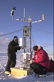 |
Jonathan Thom (left), SSEC, and Douglas MacAyeal, University of Chicago and principal investigator on the mission to track Iceberg B-15A, together set up a University of Wisconsin-Madison Automatic Weather Station. |
On the CBS Early Show (February 14), Doug MacAyeal explained iceberg causes and size. He and Jonathan Thom were shown silhouetted against the icy white expanse as the team hoisted an AWS into place on the iceberg. CBS also showed the animated satellite images provided by AMRC’s Matthew Lazzara. Madison’s WMTV Channel 15 and WISC TV-3 mentioned the iceberg project on February 14. Tom Skilling on Chicago’s WGN-TV covered the iceberg mission, featuring Douglas MacAyeal, on February 22. Enlivening the story, MacAyeal noted that the water in Iceberg B-15A would provide a “25 pound bag of ice cubes to every person on Earth for 75 years,” or “8 feet of fresh water over all of Texas.” CNN, Fox News and numerous regional television outlets also featured the mission.
- UW–Madison Communications
- SSEC Release
- University Communications, Release 1
- University Communications, Release 2
Ernest Mastroianni capped his month-long Antarctica series in the Milwaukee Journal Sentinel with the story of placing equipment on Iceberg B-15A on February 19. A story by Jack Williams ran in USA Today on February 20. The New York Times “Science Times,” Tuesday, February 20, noted the equipment mission in Henry Fountain’s Observatory column. Fountain has followed the iceberg’s progress since it first broke from the Ross Ice Shelf in March 2000. Jonathan Thom spoke with New Scientist writer Ian Sample.
USA Today used the video on its Web site. Jack Williams, Weather editor, featured the mission with a picture of Thom and MacAyeal hoisting an AWS into place. NASA’s Earth Observatory site noted that CBSnews.com mentioned the mission. Jerry Bowen covered the story on February 14, using a “rogue iceberg” theme.Wisconsin Week Wire, online version of the UW–Madison campus newspaper, mentioned Jonathan Thom’s work in the February 21 issue and acknowledged theUSA Today story in the February 26 “UW Newsmakers” column.
Science News’ annual column, “Science News of the Year,” for 2000, featured iceberg B-15. We were not mentioned, but where besides satellite imagery on the AMRC Web site have you seen a “Connecticut-size iceberg”?
The German text book publisher, Ernst Klett Verlag GmbH, will use an AMRC iceberg image in their revised schoolbook, Mathe live 8. The NOAA-12 image was taken in late March, before B-15 broke into pieces.
More than Icebergs
For More Information
A. Sun
The Antarctic Sun, Antarctica’s newspaper, features two SSEC projects in its online version. The giant iceberg, B-15A, dominates the horizon in a picture leading the issue. Reporter Josh Landis notes that researchers from the University of Chicago and the University of Wisconsin–Madison placed equipment on the iceberg to monitor weather conditions as it moves around the Southern Ocean. Below the iceberg story, the Sun covers Dept. of Physics project, AMANDA (Antarctic Muon and Neutrino Detector Array), which Scientific American has called one of the “seven wonders of modern astronomy.” SSEC has administered Amanda since 1999 in its Antarctic Astronomy and Astrophysics Research Institute (A3RI). The article notes that “AMANDA . . . is just the prototype to a project with 10 times the number of sensors and, at $250 million dollars, 25 times its price. . . . The next step, the much larger project called IceCube, will also detect neutrinos, but will focus on finding them from the farthest places in the universe.”ICDS
“100-year-old air” is being captured at the South Pole, according to Knight-Ridder reporter Seth Borenstein, in the Wisconsin State Journal for February 9. Borenstein interviewed researcher Jim Butler with NOAA’s Climate Monitoring and Diagnostics Laboratory. He barely mentioned the painstaking drilling and coring procedure, showing Tony Wendricks, coordinator of SSEC’s Ice Coring and Drilling Services at a winch. The ICDS, a new SSEC project, provides expert drilling and coring for all projects funded through the National Science Foundation that require such services.
After the article’s appearance, we wrote to the Wisconsin State Journal briefly describing all SSEC’s Antarctic projects. The letter to the editor ran on Saturday, February 17.
Speaking of Ice . . .
For More Information Lake ErieScott Bachmeier (in SSEC’s CIMSS) and Jeff Key (NOAA, at SSEC) used satellite imagery to analyze ice covering much of the eastern portion of Lake Erie on February 12, 2001. Visible imagery from NOAA’s Geostationary Operational Environmental Satellite (GOES-8) showed large ice fissures that formed in response to local atmospheric forcing. Visible channel imagery at 250 meter resolution from the Terra satellite’s Moderate Resolution Imaging Spectroradiometer (MODIS) instrument revealed even greater detail in the lake ice and fissure structure.
Weather Research
For More Information
Jeff Key (NOAA) and Chris Velden (SSEC) have modified code for deriving winds from geostationary satellite data to work with MODIS (polar-orbiting) data mapped to a polar stereographic projection. SSEC is known for its ability to track clouds and water vapor to show wind motions and to automate them. Key and Velden applied the algorithm to a sequence of MODIS images over the western Arctic Ocean. Results are encouraging, with numerous cloud targets identified and tracked.
Jeff Key has released new, improved version 3.2 of the Cloud and Surface Parameter Retrieval (CASPR) system for analysis of polar Advanced Very High Resolution Radiometer (AVHRR) data. CASPR can be used to estimate surface temperature and albedo, cloud properties, and surface radiative fluxes from space. As a result of recent validation efforts with data from the Surface Heat Budget of the Arctic (SHEBA) experiment, cloud detection has been improved significantly. CASPR is used for research and education by students and scientists in more than 15 countries and is available free over the Internet.
Using their Wildfire Automated Biomass Burning Algorithm, Chris Schmidt (SSEC) and Elaine Prins (NOAA) are serving half-hourly fire-mask GOES images in near real time to NOAA’s National Severe Storms Laboratory and the Storm Prediction Center via anonymous FTP, in SSEC’s Man Computer Interactive Data Access System (McIDAS) format. Bob Rabin (NOAA/NSSL) is using the files to create 24-hour composite summaries of fire activity in the United States for use in fire-weather emergency management activities.
In keeping with their long history of helping to develop new weather satellite instruments, Tim Schmit and Gary Wade (NOAA’s Advanced Satellite Products Team stationed at SSEC) and CIMSS researchers Scott Bachmeier and Mat Gunshor recently created a set of images to simulate a modified GOES Imager. The images, requested for the Assistant Administrator’s office of NOAA’s National Environmental Satellite, Data, and Information Service, simulated the finer resolution of the water vapor band (6.7 micrometer) on the imaging instrument for GOES-M, to be launched this July.
 |
Click on the single image for a comparison of MODIS images in 4 and 8 km resolution. |
The team sampled 1-km MODIS data (at the 6.7 micrometer wavelength) in both 8 and 4 km resolution to approximate the spatial resolution changes a National Weather Services forecaster will observe when using the Advanced Weather Interactive Processing System in the transition from the current GOES-8 (8 km) to the GOES-M (4 km) Imager. The team received the NESDIS request the morning of February 12. Thanks to the ready availability of data in SSEC’s Data Center and the team’s knowledge of SSEC’s McIDAS, they delivered the sample images by early afternoon.
On the Net
For More Information
CIMSS researcher Suzanne Wetzel Seemann provided NASA with a set of MODIS images showing the ash plume of the Cleveland Volcano on Chuginadak Island in Alaska’s Aleutian Islands. Besides the true-color image acquired at SSEC on February 19, Wetzel Seemann provided three different views utilizing infrared bands to more clearly delineate the smoke from cloud. One view shows how different MODIS bands (wavelengths) can be used to enhance a specific part of the image, in this case, the smoke plume, to make it more visible.
*this is a web-archived version*
SSEC is listed as the top “cool site” in PopularSites.com, in its 15-member list of satellite imagery sites. The whole list is worth a bookmark for its satellite coverage of individual areas around the world.
In Print
Milwaukee Journal Sentinel science reporter John Fauber fairly rhapsodized about snow in his January 15 column. It seems he’s missed it these past few years. This year, though, he says, he’s had extra time out in the cold, white, sometimes beautiful, stuff and finds himself observing new phenomena. He asked Steve Ackerman, CIMSS Director, about ice crystals that blanket the landscape. Ackerman, an expert in optical phenomena, told Fauber that they are the product of “very thin fogs.” The icy cold water droplets evaporate and freeze in crystal form, covering everything with magic.
Broadcast
For More Information
Weather Guys Steve Ackerman and Jonathan Martin (AOS) faced interesting questions on their February 26 appearance on Larry Meiller’s WHA call-in show. Jon Martin was able to expound on the differences between dynamic meteorology and climatology, Steve Ackerman explained the complexities behind strategies to combat global warming. You can listen to the Weather Guys over the Internet on the last Monday of every month at 11:45 A.M. central time.
National Geographic’s “Storm of the Century” was shown on PBS in mid-February. The “hero” of this documentary recounting a March 1993 storm was “the weather forecaster.” A RAMSDIS version of McIDAS could be seen whenever regional NWS offices were shown.
University Communications
For More Information
Wisconsin Week for February 14 reported the UW–Madison Faculty Senate decision to approve honorary modified professor titles for academic staff. Wilt Sanders, scientist at SSEC and the Department of Physics, is serving as Academic Staff Executive Committee chair. Sanders appreciates the “good intentions” of the Senate, but notes that, “Their approach to academic staff titling appears inconsistent with shared governance, in that academic staff members have the primary statutory responsibility for academic staff personnel matters.” Sanders “looks forward to working with UW System to move forward with the professor title series for academic staff.” The article states some pros and cons of giving the professor title to academic staff.