Monthly News Summary – April 1998
Observing the Human Fingerprints
by Terri Gregory, SSEC Public Information Specialist
When the first satellite in the Earth Observing System is launched this summer, scientists around the world will begin to get the most complete picture yet of how small-scale human and natural changes can affect global climate.
Scientists at SSEC’s Cooperative Institute for Meteorological Satellite Studies (CIMSS) have been working with NASA to develop some of the instruments aboard these satellites. The Moderate Resolution Imaging Spectroradiometer (MODIS) instrument, one of five on the first EOS satellite, will be used to monitor and study thin cirrus clouds and vegetation.
Good Morning
The EOS-AM, so named because as it travels south, it crosses the equator at 10:30 a.m. local time, will orbit about 400 miles above the Earth. This will be the first step in establishing a “global snapshot” to be used in monitoring the Earth for the next 18 years. Using MODIS and other instruments, scientists will try to identify human “fingerprints” on global change.
Ever since EOS was a gleam in NASA’s eye, CIMSS scientists have worked with NASA’s Goddard Space Flight Center on the MODIS Airborne Simulator (MAS), a test instrument carried by airplanes. MAS observes the Earth in 50 spectral bands, simulating the measurements to be collected by the satellite version, which will use 36 bands. Another important CIMSS contribution in MODIS development was developing the software that will generate cloud, atmosphere, and ozone products from MODIS data.
The Earth Observer, NASA’s EOS newsletter, reports that the MODIS Atmosphere Group will process MODIS data about eight days a month, while data from CIMSS’ cloud mask algorithm will be processed continuously. Atmosphere Group member Liam Gumley has developed a visualization tool for MAS (and eventually MODIS) called SHARP. This user-friendly software allows users to add the cloud mask overlay, do simple band math, and create GIF files on screen. Steve Ackerman will work on comparing and validating MODIS data. Steve has already demonstrated that MAS cloud mask results agree with Lidar and other types of data.
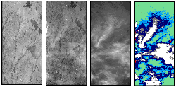 |
This image shows how CIMSS scientists use the cloud maks computer algorithm to detect practically invisible clouds. See a larger version and an explanation. |
EOS Talks to McIDAS
Recently, SSEC’s McIDAS team has enhanced the system for MODIS data. McIDAS, developed to display and analyze many kinds of satellite and other data, can now directly access the simulated MODIS data stored in an EOS proprietary format.
A new McIDAS interface called MODView allows users to display and manipulate MODIS data over the Internet. The data can be overlaid with maps, grids, and data from other sources. MODView is the first Java application written as a user interface for McIDAS.
Launch of EOS-AM has been delayed from the planned date of June 30,Aviation Week & Space Technology reported on March 16. “A combination of problems will force a slip of 30-60 days, program officials confirm.” Some factors contributing to the delay are “difficulties with ground software, spacecraft testing delays caused by late delivery of instruments, and launch pad availability.” Lockheed Martin is building the spacecraft, but several organizations have developed the instruments on the satellite.
Testing, Testing
CIMSS scientists will also help test an instrument that will fly on the second EOS satellite. EOS-PM (yes, it crosses the equator in the afternoon) is set to launch in December 2000. The Atmospheric Infrared Sounder (AIRS) instrument will be used to provide accurate temperature and water vapor profiles.
AIRS, like all satellite instruments, is undergoing the long process of careful building and testing. An engineering model is nearing completion in preparation for testing, after which the flight model will be built and tested. The AIRS will be calibrated and tested by comparing its results with results from other instruments such as weather balloons and Lidar.
A valuable source of comparison is SSEC’s Atmospheric Emitted Radiance Interferometer (AERI). The AERI has been proven to make useful profiles of the atmosphere in Department of Energy campaigns to study elements of global warming.
Data from other weather experiments will also be used to validate the data the AIRS engineering model collects. This fall, the Convection and Atmospheric Moisture Experiment (CAMEX 3) will collect many kinds of atmospheric information that can be used to test AIRS software. Both the MAS and AERI instruments will be included in CAMEX and their data will be among that used to validate AIRS.