Buffering runoff
Molling’s group provided the WBI with information about the effects of runoff on individual fields. Using PALMS, researchers estimated how much runoff would leave a field at each point along its boundary.
MADISON — Wisconsin’s famous dairy cows and other farm animals excrete phosphorus in the form of manure, which farmers generally apply to fields as fertilizer. Often, the nutrients in manure and other agricultural fertilizers flow off the fields during rain storms or when snow melts, and into nearby streams and lakes. Phosphorus affects water quality by over-fertilizing algae, which can result in toxic algal blooms and consequent low oxygen levels. Fish and other aquatic life often suffer. These adverse effects are referred to as non-point pollution.
The redesign of Wisconsin’s non-point pollution control program in 2000-2001 resulted in controversy over the role of riparian buffers, or strips of plants placed alongside lakes and rivers. These buffers reduce water pollution by filtering out sediment and phosphorus from runoff. The controversy, mainly between environmental and agricultural groups, led to the Wisconsin Buffer Initiative (WBI). SSEC researcher Christine Molling became involved in the WBI through a complementary project to quantify phosphorus losses from agricultural fields.
In 2002, the WBI, led by University of Wisconsin’s Pete Nowak, set out to provide a practical, fiscally responsible, scientifically-based plan to regulate the installation of buffers in Wisconsin. Molling and other UW-Madison researchers from several departments collaborated with representatives of a wide range of interested groups, including: Wisconsin’s Department of Natural Resources, several environmental groups (e.g., Trout Unlimited, River Alliance of Wisconsin), several farming organizations (e.g., Wisconsin Farm Bureau Federation, Professional Dairy Producers of Wisconsin), state and federal agencies (e.g., DATCP, Farm Service Agency), and staff members from the Wisconsin Association of Land Conservation Employees.
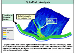
The collaboration among WBI members produced a set of tools to help Wisconsin get the “biggest bang for the buck” for every buffer installation. The tools serve to point out where buffers would best improve water quality throughout the state. The tools cover the entire range of scales, from statewide, watershed, and subwatershed, all the way down to farm and partial field scales. For example, at the state-wide scale, the group provided a ranked list of watersheds based on where buffer technology is most likely to improve water quality and aquatic life. Molling’s contributions were focused primarily at the field to sub-field scale.
The project that sparked Molling’s involvement with the WBI involved monitoring and modeling sediment and phosphorus in runoff from four Wisconsin family farms and the University of Wisconsin’s Arlington Agricultural Research Farm. A collaborative effort, this project brought together scientists and researchers from UW–Madison’s Soil Science Department, Biological Systems Engineering, and SSEC.
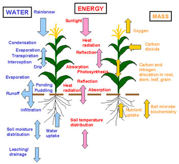
PALMS uses equations to simulate the physical processes involved in the transport of water, heat, and mass within the atmosphere, canopy and soil system.
For the WBI, Molling’s group adapted the model used in the preceding monitoring study. The model, called the Precision Agricultural-Landscape Modeling System (PALMS), calculates an indicator known as the contributing area, which estimates how much runoff might leave an individual field at each point along its boundary. Using detailed topographical maps, Molling’s group found that on any field, runoff at the edges varies widely because the farm field is not uniform in slope or shape. Molling’s contributing area calculations led WBI members to recommend that buffers should be designed with contributing areas in mind. If more runoff is expected to leave a field in one location versus another, then the buffer should be wider in the section with the greater contributing area, and can be narrower in the section that contributes less runoff.
Initially the WBI’s research focused on questions about buffer size and location. Buffers are a good way to prevent sediment and phosphorus from entering the water, but they also serve as reservoirs for materials that have the potential of being washed into the water during a large runoff event or flood. Observing how runoff events occur on working farm fields led Molling and her colleagues to ask the question, “Wouldn’t it be better to keep the sediment and the phosphorus up on the field instead of letting it get to the edge?”
As the WBI members discussed this question, they began to realize that buffers should really be the last line of defense, not the only line of defense, against non-point pollution. Consequently, one of the WBI’s recommendations was that erosion control on farm fields be the first step in protecting water quality. A good tool for this purpose is a nutrient management software package, called SNAP-Plus.
Measurements of runoff, sediment, and phosphorus on the five farms involved in the monitoring study conducted by Molling and others provided valuable evidence that SNAP-Plus was accurate in estimating annual erosion and phosphorus losses from agricultural fields. In a pilot study using SNAP-Plus on several farms in Green County, WBI scientists found that in many cases, management changes may reduce erosion so much that a buffer may not be necessary. Beneficial changes include: switching to no-till practices, and leaving a dense cover of crop residue on the field after harvesting.
Farmers have thus far been pleased to learn that they may have the option to keep most or all of their fields in production by adopting certain land management practices, and taking land out of production for buffer installation only where the landscape requires it. Environmental groups are pleased because money will be spent on putting buffers where they are likely to improve water quality the most.
Working on a project that brings together several diverse perspectives was a new experience for Molling. “For me it was a unique opportunity to see science go straight to work on an issue that affects every Wisconsin citizen,” Molling said. “And it was also new for me to be forced to deal not just with the scientific aspects of an issue, but the financial, social, and regulatory aspects as well.”
For details on the WBI, a full list of the participants, and the WBI’s recommendations, the full report can be read on line.
###
Direct comments, suggestions and inquiries to Terri Gregory, SSEC’s Public Information Coordinator. For past features and columns, see SSEC’s News page.