Distance learning trains weather forecasters
The National Weather Service has selected a distance-learning software tool developed at the University of Wisconsin-Madison to deliver scientific training over a high-speed Internet network.
In March, NWS training officials met at the Operations Training Branch in Norman, OK to choose teletraining software. The distance learning software chosen, VISITView, was developed by the Space Science and Engineering Center to help forecasters learn to use a new forecasting system. Keystone of the National Weather Service’s modernization plan, AWIPS, short for the Advanced Weather Interactive Processing System, integrates all data used by forecasters—radar, satellite imagery, model output. For the first time in NWS history, all forecasting data is provided in one place. Through VISITView driven training, forecasters are taught relatively painlessly how to use AWIPS to become better forecasters.
Before AWIPS, the NWS primarily relied on “residence” or in-house training, but found a mix of residence, teletraining, and other techniques was a more cost-effective training method for all employees, not just forecasters. VISITView is an important part of this mix.
VISITView is based on the highly interactive Java programming language, allowing experts to develop individual training modules delivered as teletraining that shows the forecaster how to exploit new science and analysis capabilities. NWS set up the VISIT (Virtual Institute for Satellite Integration Training) Program to “accelerate the transfer of research results based on atmospheric remote sensing data into NWS operations. This transfer is accomplished through the education of NWS forecasters on the latest techniques to integrate remote sensing data, especially from satellite and radar.”
VISITView development for the Weather Service began at SSEC two years ago, said Tom Whittaker, who leads the effort. Since the NWS owns the software, said Whittaker, they can make any changes to it they need. VISITView was developed primarily to deliver teletraining materials for imagery to replace a software program no longer being supported. Whittaker said that VISITView has evolved to a “robust and useful tool for synchronous and asynchronous teletraining activities, combining interactivity with flexibility.” He hopes it will continue to evolve with forecasting needs.
To try VISITView, Go to the VISITView home page. After the Big Red Pointer appears, just click on the red-colored “Next” at the bottom of the screen. You may need to scroll down to see the controls. All you need to use the application is accessible through button controls. New users may wish to start in the “Select Page & click Selected Window” with #1. When you click the red “Selected” button, data appears and the situation unfolds as though it were happening in real time. Drawing on the screen does not interfere with any sessions that may be underway in a National Weather Service office; many different users can use the system at a time, in training sessions or separately.
The National Weather Service is the primary customer for VISITView but the program could be useful to other organizations as well, suggested Scott Bachmeier, SSEC scientist on the project. “The FAA or educators, or anyone interested in weather forecasting,” said Scott, “can benefit from VISITView’s interactivity.” The software has been made freely available to all Universities with Atmospheric Science programs. The Cooperative Program for Operational Meteorology Education and Training who produces training courses on CD, is experimenting with VISITView for live Webcasts and will add streaming audio. VISITView is also being used for collaborations using real-time data, not just canned training materials. Tom Whittaker said, “This will help people gain experience with this emerging technology, and help to determine how best to use it in the future.”
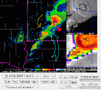
Training modules using VISITView show how to use AWIPS in a variety of cases, such as heavy snow, tropical weather (hurricanes), and severe convection that can produce hail, tornadoes, or flooding. For example, Scott said, he picks a case study like the heavy snow that fell on Midland, TX in December 1998 and then presents several different ways of interacting with the information, presented as AWIPS would show them. Tom Whittaker explained that, “Students and instructors can add annotations of text or line-drawings on the screen during the training.”
VISITView can mimic AWIPS screens or output, comparing and combining a variety of data from a number of sources. “Interactivity is key,” said Scott. “It’s easy to put up slides, but here you can draw on the screen and even include audio.” VISITView is built on Java, a modular cross-platform programming language developed by Sun microsystems in the 1990s. Developers use Java to produce applications that can be used on any operating system—UNIX, Macintosh, Windows.
One thousand certificates have been given for 82 individual training sessions in the past year, involving 230 offices across the country.
SSEC software developers of VISITView include Tom Whittaker, Tommy Jasmin, Tom Rink and David Glowacki (technical consultant). Scott Bachmeier is responsible for science content and applicability to real-life forecast scenarios. Others develop training materials and help to define the evolution of VISITView at the Operations Training Branch (Norman, OK), the Cooperative Institute for Research in the Atmosphere (Ft. Collins, CO), and COMET (Boulder, CO).
For more information contact: SSEC’s Public Information Officer or at 608-263-3373.
For information about past media appearances, visit SSEC In the News.