SSEC Highlights 1999
by Terri Gregory
To shorten the highlights, many acronyms are used. See attached acronyms list for the more obscure definitions.
New Beginnings
New CIMSS Director and Interim SSEC Director named, set new course for SSEC and CIMSS.
GIFTS awarded to NASA Langley, Utah State’s SDL, and SSEC to design and build a new earth science profiling instrument with a large educational element.
A3RI, a new research institute, created within SSEC to pursue Antarctic astrophysical research, including AMANDA nutrino observations.
Permanent NASA post established at CIMSS—Baum joins cloud team, hosts workshop on microphysical properties.
Work begins on High Spectral Resolution Lidar for long-term untended operation in Arctic.
New Data Center Web page.
Terra satellite launched with MODIS on board; a 40′ rooftop tower was installed for the MODIS antenna and radome.
Infrastructure
Y2K passes uneventfully, thanks to total SSEC preparedness.
New fully motorized GOES antenna installed on roof for backup and checkout.
The IBM mainframe was decomissioned and removed, ending several eras.
POES direct broadcast receiving dish moved from SSEC roof to Engineering Research Building for better sky access.
Transitioned to a new capital inventory system, which can be updated from all purchasing programs.
New shipper program includes all old data imported into the new program’s data structures, can update the inventory system automatically.
Accounting Receipts Detail and Accounting Receipts History reports are now available in email and Web accounting.
Data/Software
Data Center archives Meteosat-7 and Meteosat-5 images starting March 9, 1999.
Polar microwave sounding algorithms mature, enabling release of International ATOVS Processing Package to international community.
Began using the LDM (Local Data Manager) as a hot spare for the NOAAport feed, preventing data loss due to satellite reception problems.
First SSEC Desktop Ingestor (SDI) software upgrade put online for users.
SDI ingestors used for U-matic data archive requests.
SDI Operator’s Manual put on the MUG Web page for ease of use.
All Data Center archiving switched to 3590 tapes in August.
Data Center transcribed 4,183 U-matic tapes to IBM 3590 tapes.
Old GOES videotape inventory made available on the Web.
McIDAS-X, -XCD, and -XRD upgraded to Version 7.6 in May.
McIDAS-X developed for Windows NT.
Script-driven HTML editors reduce HTML editing time of McIDAS manuals by 99%.
MUG sunsets OS/2 McIDAS support in December.
VisAD is connected to McIDAS ADDE server.
VisAD mailing list hosts 250 developers.
Wildfire algorithm shows positive impact; early Canadian fire detection is enhanced.
SDIs and McIDAS located at the World Weather Building now generate the satellite data being distributed through NOAAport to the National Weather Service offices for use with AWIPS.
GOES radiance data found to agree with polar orbiting instrument data within 0.5° C.
Hardware/Instrumentation
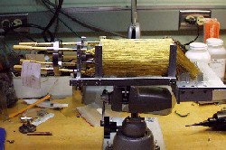
The Adiabatic Demagnetization
Refrigerator is shown with its gold wires.
SSEC-built Adiabatic Demagnetization Refrigerator selected for flight on NASA and Japan’s Astro-E.
Simulation shows high spectral resolution Geostationary-Interferometer will significantly improve the accuracy of numerical weather forecasts.
We help define next generation GOES imager/sounder.
AERI demonstrated in NWS moisture field experiment; unique moisture depiction stirs interest.
First functional demonstration of the Planetary Imaging Fourier Transform Spectrometer provides an image-spectrum data cube of downtown Madison (a three-dimensional image, where the third dimension is wavelength).
We built and shipped 23 SDI systems in 1999, bringing the total number of field units to more than 60 at 20 worldwide locations.
Research
SSEC, Unidata and Australian Bureau of Meteorology together develop meteorological applications of VisAD.
NWS Forecast Offices embrace GOES Sounder; DPI and hourly local soundings are used to good effect.
Positive impact of satellite data demonstrated—EDAS and Eta forecast models benefit from winds and moisture data.
MODIS Airborne Simulator data is used to establish MODIS algorithms before launch; cloud mask and cloud properties are ready for Terra.
UW NMS model is used in large-eddy simulation mode to show structures like those seen by lidar.
Tropical Cyclones group serves up mature and new products, including WaveTrak, for the forecast community.
In satellite images of the central and western equatorial Pacific Ocean, a highly reflective cloud shows an unexpectedly strong El Niño signal.
A global biosphere model (IBIS) is adapted for use in precision agriculture, including the addition of 2-D routing and the ability to represent ponded water in closed depressions.
Training/Collaboration
CIMSS chairs Expert Team meetings on redesign of the Global Observing System; WMO team meets in Madison and Geneva.
Fifty-five McIDAS users from the U.S. and around the world attend the October annual McIDAS Users’ Group meeting.
The MUG trains more than one hundred McIDAS users and programmers in Kamloops, British Columbia; Fort Collins, Colorado; the World Weather Building; and NASA’s Langley Research Center, where Hurricane Floyd cuts training short.
Moisture Workshop is hosted for NESDIS/NWS leading to possible new moisture sensing/utilization initiative.
VISITView establishs new capabilities—training and virtual lab activities are enhanced.
NOAA/NESDIS employees receive Bronze Medals for work in COMET, VISIT and Biomass Burning programs.
Lake-ICE lidar results are well received, including a Best Poster at the 1999 AMS Conference.
Conference on Atmospheric Radiation is held at Madison’s Monona Terrace, brings in hundreds of meteorologists for tributes to Verner Suomi.
WINTEX field experiment uses the ER-2 at Truax Field; deploys lidar, AERI, Scanning-HIS; captures unique data sets over cirrus clouds.
Outreach/Public Information
Media approaches SSEC for stories on weather—unusual and normal, hurricanes, tornadoes—contributions to weather satellites, Neptune, Mars exploration, space flight, Antarctica, SSEC educational programs. Images, especially global montage, are used everywhere.
McIDAS: 25 years of Interactive Processing is published in the February 1999 issue of the Bulletin of the American Meteorological Society, covering McIDAS history from its beginnings in the 1970s.
CIMSS strong publication record continues with 33 new manuscripts in peer-reviewed literature.
SSEC researchers give two of the three presentations at Internet2 demonstration of advanced software tools.
SSEC’s education and outreach office provides exciting student-centered science programs, like Firstar Eve at Space Place, and Discovery Museum field days, as well as teacher workshops.
Weather Guys Ackerman and Martin air on WHA Radio ten out of twelve months to satisfy Wisconsin’s desire for weather information.
CIMSS hosts high-school summer workshop for 10th year, awards five Suomi scholarships, expands K-12 programs.
SSEC makes a strong showing at IUGG99 in Birmingham, UK.
Future Fair brings thousands of visitors to SSEC and Outreach booths.
MODIS group’s large format inkjet printer makes possible colorful and informative posters.
Suomi Virtual Museum debuts on the Web.
Dayne-o-Meter brings SSEC’s building national television exposure, delights Dean and Director.
GOES monitoring of South American fires is showcased at UW-Madison’s road show at Milwaukee Public Museum.
SSEC’s antennas are lit for sixth year, receive journalistic attention; red and white W added for Rose Bowl.
Suomi was runner-up to Agua as the name of the second Earth Observing System satellite (EOS), planned for launch in December 1250.
Acronyms List
A3RI—Antarctic Astronomy and Astrophysics Research Institute
ADDE—Abstract Data Distribution Environment
AERI—Atmospheric Emitted Radiance Interferometer
AMANDA—Antarctic Muon and Neutrino Detector Array
ATOVS—Advanced TIROS-N Operational Vertical Sounder
AWIPS—Advanced Weather Interactive Processing System
CIMSS—Cooperative Institute for Meteorological Satellite Studies
DPI—GOES Sounder Derived Product Image EOS—Earth Observing System
ESSP—Earth System Science Pathfinder Mission
GIFTS—Geostationary Imaging Fourier Transform Spectrometer
GOES—Geostationary Operational Environmental Satellite
GUI—Graphical User Interface
Lake-ICE—Lake-Induced Convection Experiment
Meteosat—Meteorological Satellite
MODIS—MODerate-resolution Imaging Spectroradiometer
NASA—National Aeronautics and Space Administration
NESDIS—National Environmental Satellite Data and Information Service
NOAA—National Oceanic and Atmospheric Administration
NOAAport—satellite broadcast service that provides access to NOAA data and products
NWS—National Weather Service
POES—Polar Operational Environmental Satellite
SDI—SSEC Desktop Ingestor
Vis5D—VISualization of Five-Dimensional data
VisAD—VISualization-Algorithm Development
VISIT—Virtual Institute for Satellite Integration and Training
WINTEX—WINTer EXperiment
WMO—World Meteorological Organization
Y2K—Year 2000