Source of High Ozone Tracked Down in Wyoming
Thunder Basin, Wyoming, found itself threatened by an invisible invader on 6 June 2012. Carried by the wind, high levels of atmospheric ozone descended into the remote, sparsely populated northeast corner of the state. Ozone normally circulates in the stratosphere, providing a vital shield against harmful solar radiation, but if it intrudes into the troposphere as it did on that day, ozone can cause various respiratory problems in humans.
For this reason Brad Pierce, a NOAA/NESDIS scientist stationed at the UW-Madison Space Science and Engineering Center (SSEC), and one of the Principal Investigators of the NASA Air Quality Applied Sciences Team, is working with SSEC scientists to use satellite data to study ozone, and more specifically so-called stratospheric intrusions (SI).
Raised levels of ozone in the troposphere are usually caused by anthropogenic sources such as smog or related polluting factors, but on occasion an SI event – a downward transport of stratospheric air that pushes its way very deeply into the troposphere – can increase ozone content to dangerous levels.
Surface monitors in Wyoming showed that the concentration of ozone in the air reached nearly 100 parts per billion (ppb), with 8 hour averages registering above the 75 ppb public health standard established by the Environmental Protection Agency (EPA).
“In this case,” Pierce says, “the State of Wyoming needed to prove that the elevated ozone readings for June 6th were caused by an intrusion of stratospheric air rather than pollution, otherwise they would be in violation of the Clean Air Act.”

GOES Total Column Ozone (DU) for 3 pm MST 06 June 2012. Elevated (larger than 350 DU) column ozone is found over the Pacific Northwest. The stratospheric ozone that influenced Northeastern Wyoming is associated with the thin filament of higher column ozone that extends from Baja California through the Four Corners region and is largely obscured by clouds over Wyoming. Image courtesy of SSEC Data Center.
The Clean Air Act requires that states and tribes attain the National Ambient Air Quality Standard (NAAQS) for ozone, currently defined as a 3-year average of the 4th highest daily 8-hour average ozone greater than 75 ppb. If the NAAQS is violated, EPA may designate areas as failing to meet the ozone levels standard, necessitating the development of plans for improvement in air quality. However, heightened ozone levels caused by exceptional events (usually from natural sources) can be excluded if explained by appropriate documentation.
The Wyoming event provided an opportunity for Pierce and the team to apply some new strategies using both satellite and surface observations to determine the source of the increased ozone levels.
“We were looking for evidence that the ozone of the Thunder Basin event came from the stratosphere,” Pierce explains. “We ran back-trajectories, backward in time, to see where that air came from. The back-trajectories went back to a very persistent cyclone circulating around the Aleutians. These high amplitude troughs that we often see over California in the springtime come off of the Pacific. Then, because of the high topography, the ozone that comes in with these troughs will often affect the western mountain states.”
The team’s primary tool was the IDEA-I (Infusing satellite Data into Environmental Applications – International) project, which they developed as part of the NASA International Atmospheric Infrared Sounder (AIRS) and Moderate Resolution Imaging Spectroradiometer (MODIS) Processing Package (IMAPP) and the NOAA Community Satellite Processing Package (CSPP). Version 1.0 of IDEA-I was released in June 2012 and uses MODIS Aerosol Optical Depth (AOD) retrievals to identify local regions of high aerosol loading from which trajectories are initialized.
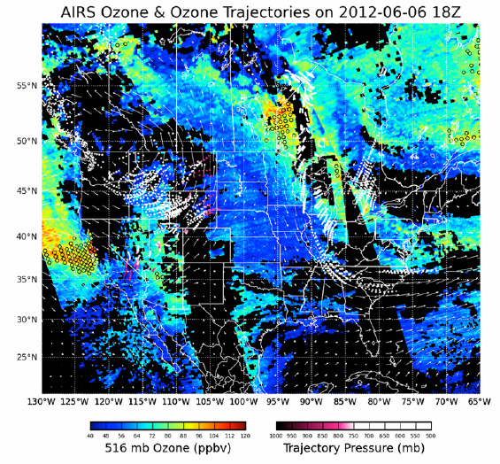
IDEA-I SI forecast (red and white trajectories over Wyoming, Idaho, and Montana) valid at 18Z (11am MST) on 06 June 2012 initialized with AIRS ozone observations from 04 June 2012. The IDEA-I SI trajectories are initialized in regions of high ozone (open circles) off the coast of California and show the downward transport (red indicates high trajectory pressures near the surface) of the high ozone air over Northeastern Wyoming and Montana. The initial AIRS ozone retrieval at 516mb (mid troposphere) is also shown along with 500mb winds from the NOAA Global Forecasting System (GFS) which are used to predict the trajectory movement. Image courtesy Jim Davies, SSEC.
To gather both daytime and nighttime data the team uses the UW Hyperspectral retrieval package, which obtains surface and cloud products from the AIRS, the Infrared Atmospheric Sounding Interferometer (IASI), and the Cross-track Infrared Sounder (CrIS), (all satellite-based instruments). The team retrieves six sets of observations in a 24-hour period.
Another set of measurements comes from the NASA AJAX (Alpha Jet Atmospheric eXperiment) project. Based at the NASA Ames Research Center at Moffett Field, California, AJAX airplanes can fly directly into the weather features off the coast of California that the EPA’s surface stations don’t record, and take direct readings of the ozone present.
“In this case it was a lucky break,” Pierce says. “We were tracking the Thunder Basin event backwards and found that there had been an AJAX flight two days before. We brought the AJAX team and the EPA SI teams together and now we work in tandem with AJAX. In 2013 the AJAX flights are more tightly coupled with possible SI events forecasted over California and Nevada.”
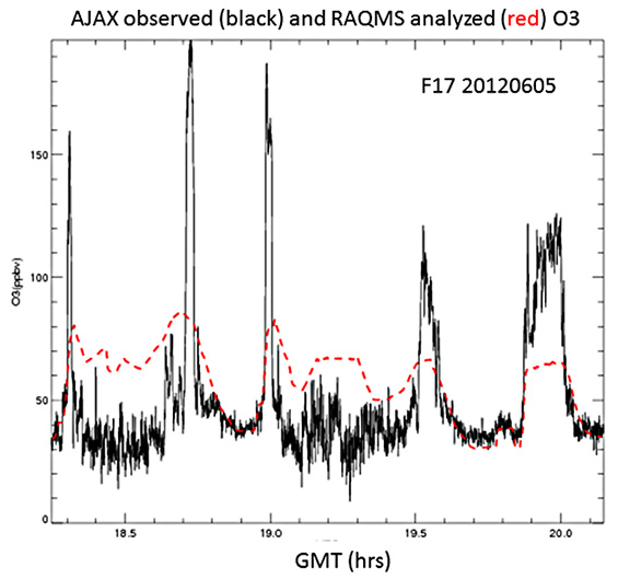
Time series of observed in situ (black) and analyzed (dashed red) O3 (ppb) along AJAX Flight 47 track on 05 June 2012. Figure courtesy of Brad Pierce (NOAA/NESDIS/STAR), Laura Iraci and Emma Yates (NASA Ames Research Center), and the NASA Air Quality Applied Sciences Team.
Pierce and the team continue to refine both their observation and prediction capabilities, including using the Real-time Air Quality Modeling System (RAQMS), a global forecast model that assimilates satellite ozone observations, to help interpret surface and airborne measurements and increase understanding of the transport of ozone from Pacific weather systems to remote corners of Wyoming.
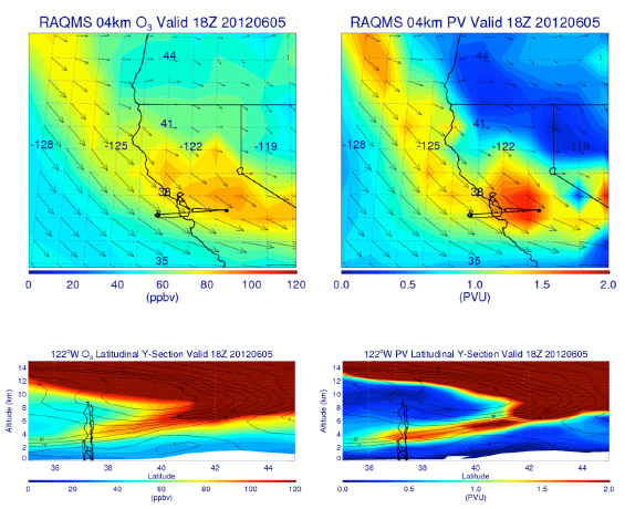
4 km O3 (ppbv, upper right) and Potential vorticity (PV, PVU, upper left) maps with wind vectors (black) maps with O3 (ppbv, lower left) and PV (PVU, lower right) cross sections at 120° W on 05 June 2012 at 1800 UTC from the RAQMS analyses. The AJAX flight track is shown in black in all images.
Note the tropopause fold indicated by the tongue of relatively strong PV and high O3 extending from the lower stratosphere into the mid-troposphere, indicating the intrusion of stratospheric ozone into the troposphere. Image courtesy of Brad Pierce NOAA/NESDIS/STAR.
Using the evidence gathered by Pierce and others studying occurrences of raised ozone levels, the State of Wyoming Department of Environmental Quality/Air Quality Division has filed a report documenting why exceeding the EPA standards in Thunder Basin was an “exceptional event,” and that in this case, the elevated ozone level was the result of a natural occurrence and not pollution.
“For the Thunder Basin incident,” Pierce says, “we used the satellite data to create back-trajectories and find the source of the ozone in the stratosphere. This same technique is what we use to do forward-trajectories. IDEA-I will help us forecast SI events by using satellite measurements to identify cases that could be stratospheric intrusions, based on satellite ozone, temperature and water vapor retrieval. This will enable us to determine whether SI’s are likely to impact surface ozone levels over the next 48 hours and where that might happen.”