Tracking meteors: A Novel Use for Environmental Satellites
On the morning of 15 February 2013 a large meteoroid traveling more than 18 km per second pierced the Earth’s atmosphere over Chelyabinsk, Russia, 1500 km east of Moscow. The 7,000 to 10,000 ton object, superheated by friction with the air, exploded with the force of 500 kilotons of TNT. On the ground, structures were damaged and hundreds of people were injured by the shock wave.
On the other side of the globe, Scott Bachmeier, a research meteorologist with the Cooperative Institute for Meteorological Satellite Studies (CIMSS), was examining satellite images from around the world when he noticed the event. The meteor left a distinct trail of dust, smoke and ice debris on a path from west to east in the stratosphere that was visible on satellite imagery of the region.
While the exact height, speed, and trajectory of a meteor are difficult to determine from ground observations alone, Bachmeier’s analysis of images from the Japanese MTSAT-2 satellite revealed something unique.
“What I found was a series of really cool images from a very oblique viewing angle that showed how high the trail was.”
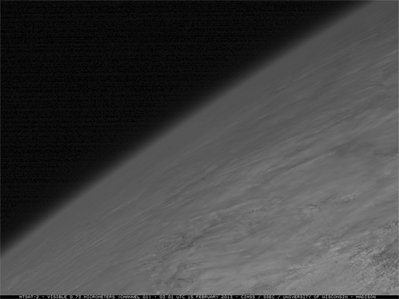
An oblique view of the meteoroid trail using 0.73 µm visible channel images from the Japanese MTSAT-2 satellite revealed that the stratospheric component of the meteor trail could be seen for as long as 9 hours with the aid of illumination from the sun.
Steven D. Miller, a researcher with the Cooperative Institute for Research in the Atmosphere (CIRA) at Colorado State University, also recognized the importance of the event after observing the meteor trail in imagery from the Defense Meteorological Satellite Program (DMSP) weather satellite.
Miller examined more satellite observations and data to see whether they could be used for trajectory reconstruction. Accurate details of a meteoroid’s trajectory are vital in determining the source of the object and the likelihood of future events from the same source, facts that could help determine if more strikes are imminent. In order to track down much of the data needed to analyze these questions, Miller contacted William Straka III, an associate researcher at CIMSS/SSEC.
Straka accessed archived data from four European and Japanese geostationary satellites directly from the SSEC Data Center. Along with data from EUMETSAT, which provided information from a fifth geostationary satellite, the team calculated end points and height of the meteor trail. The end points and height can then be used to determine the trajectory of the meteor from a satellite perspective.
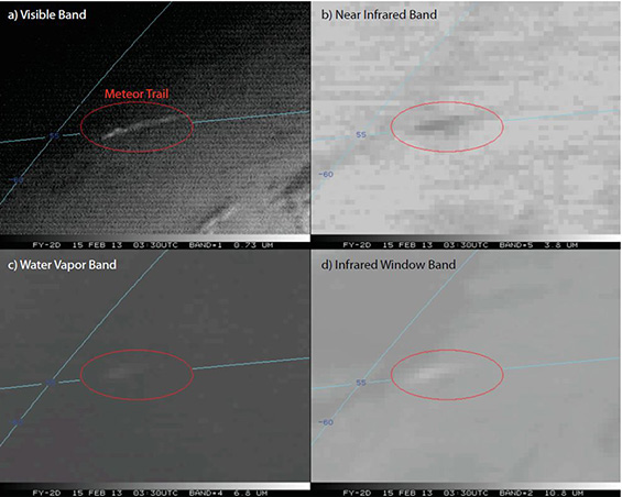
Feng-Yun 2D (a Chinese geostationary weather satellite positioned at 86.5°E) multispectral imagery of the Chelyabinsk meteor trail 0330 UTC collection time (0332 UTC actual scan time, or roughly 12 min after trail formation). The visible, near-infrared, “water vapor,” and longwave-infrared bands are shown in (a–d), respectively. The signature of the meteor trail is present in each of the spectral bands.
Straka used the SSEC-developed McIDAS-X (Man-computer Interactive Data Access System) software to calculate and analyze details of the meteoroid’s trajectory and its impact in our atmosphere. With this information Straka was able to compare the satellite-derived trajectory with trajectories calculated by surface observations.
With Miller as lead author and Bachmeier and Straka among the co-authors, a paper detailing the effectiveness of satellite reconstruction of meteoroid trajectory was recently published in the Proceedings of the National Academy of Sciences. This novel use for environmental satellites provided results that compared favorably to the surface-based estimates.
The disintegrating Chelyabinsk meteoroid left its trail over a populated area, where many eyes and cameras recorded its course. The next meteor event could occur in a less populated area and generate far less tracking data from surface observations. Earth-viewing satellites may prove to be the eyes we need to warn us of future threats.