Predicting Turbulence is a SNAAP
Turbulence in the atmosphere is the number one cause of injuries to passengers and flight crews in non-fatal airplane accidents, but it can be virtually invisible to pilots. If the invisible turbulence could be made visible, some aviation accidents and related injuries could be avoided.
Wayne Feltz, a scientist with the Cooperative Institute for Meteorological Satellite Studies (CIMSS) is researching new ways to detect high altitude turbulence to improve aviation safety. Since 2004, he has led the Satellite-based Nowcasting and Aviation Applications Program (SNAAP) team. SNAAP researchers are developing nowcasting tools to more accurately identify wave patterns in the atmosphere that will help predict where and when aviation hazards, such as turbulence, may occur.
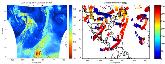
Left: Modified GOES Water Vapor channel brightness temperature in the northern hemisphere. Right: Corresponding locations of tropopause folds in the original image, where upper-tropospheric clear air turbulence is more common; the colors in this product indicate the direction of flight most likely to encounter turbulence.
Pilots know that turbulence often accompanies the vertical currents of thunderstorm convection systems and the rapid surface altitude changes near the peaks of mountains, but clear air turbulence is hard to predict and almost impossible to see. Pilots depend upon reports from other aircraft to inform them where clear air turbulence might be a problem. Today’s aircraft carry instruments that measure turbulence and automatically submit cockpit navigation data to the National Center for Atmospheric Research to compute Eddy Dissipation Reports (EDRs). This measure is an objectively derived turbulence report based upon aircraft data, in stark contrast to pilot reports (PIREPS), which were the previous standard and depended upon subjective pilot analysis.
“Over land,” Feltz says, “we have a lot of aircraft gathering data. Most EDRs are captured over the continental US. But over the ocean, pilots only report flight conditions at certain longitude lines and uplinks to send that data in real time are expensive. That’s one area where satellite observations can make a valuable contribution.”
Using water vapor imagery from satellites, it is possible to examine the boundary between the upper-troposphere and the stratosphere, looking for vertical shearing of the jet stream that can cause a tropopause “fold.” It is in these tropopause folds that clear-air turbulence is most likely to occur.
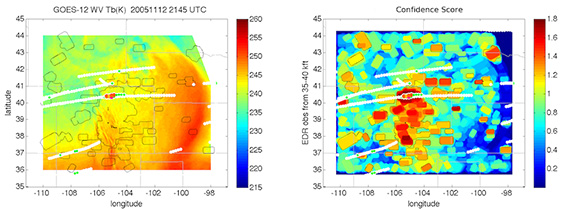
Left: Water vapor imagery brightness temperature (colors), aircraft flight track eddy dissipation rate (circles: white – null, green – light, yellow – moderate, red – severe), and higher probability turbulence scoring boundaries (grey). Right: Corresponding locations of higher confidence mountain wave turbulence; the colors in this product indicate the direction of flight most likely to encounter turbulence (blue – lowest probability, red – highest probability).
SSEC/CIMSS Associate Researcher Sarah Monette is compiling several streams of data into one clear display to produce a Turbulence Risk Image. The image combines the tropopause folds, overshooting tops of clouds and PIREPS in order to give pilots, particularly those flying routes over the ocean, accurate and timely information that will enable them to avoid invisible turbulence ahead.
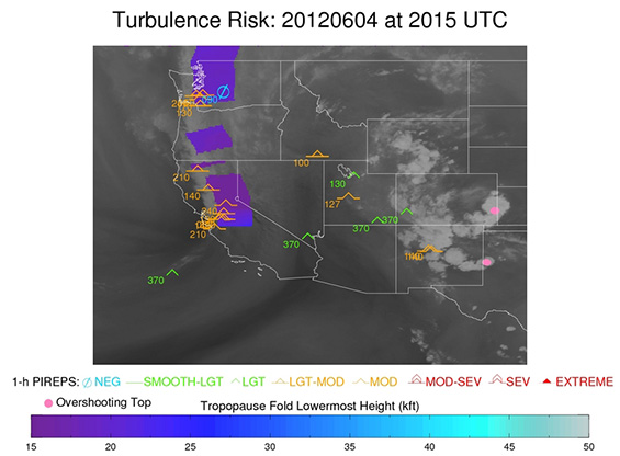
Automated quicklook showing location of tropopause fold (purple) and convective overshooting tops (pink circles) with corresponding pilot reported (PIREPS) turbulence locations.
The team then uses EDR data to validate the results gathered from the satellite observations.
“Initially, we faced some skepticism,” Feltz says, “because of the relatively low resolution of environmental satellites and initially long turn-around times. But we are building confidence in the accuracy of our output by comparing the results we obtain with the EDRs.”
The SNAPP team is hoping to use satellite data as a plane is flying over the ocean at cruise level to help give better lead times to pilots. Alerting pilots to areas where they are more likely to encounter turbulence will help them avert it and improve aviation safety.