Tracking Wildfires with the CIMSS Wildfire ABBA Product
Every day significant amounts of trace gases and particulate matter are released into the atmosphere by biomass burning worldwide. Although recent research strongly suggests that fire by-products are an important factor in climate change calculations, both the actual extent of burning and the precise impact of aerosols emitted by fires are not well understood.
Cooperative Institute for Meteorological Satellite Studies (CIMSS) Researcher Chris Schmidt leads the CIMSS Biomass Burning team which operates and maintains the Wildfire Automated Biomass Burning Algorithm (WFABBA). Developed at CIMSS in collaboration with the National Oceanic and Atmospheric Administration (NOAA), the WFABBA uses geostationary satellite data to detect and analyze instances of biomass burning worldwide.
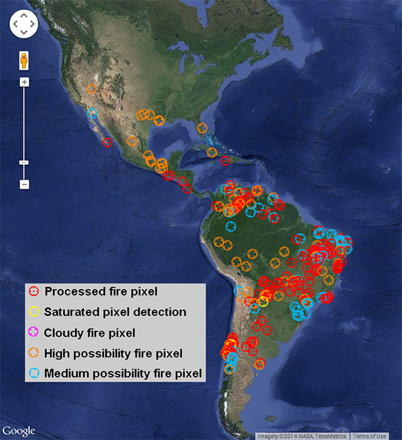
View of the Global WFABBA composite overview from the GOES-13 satellite at 15:11 UTC 08 January 2014. Fire symbols do not represent the size of the fire or the exact location. Imagery via Google Map, courtesy of NASA, Terrametrics.
The WFABBA fire algorithm uses a middle infrared band of 3.9 μm and a longwave infrared band of 11.2 μm to locate and analyze “hot-spot” pixels in satellite imagery. When run, the algorithm shows the fire’s location, an estimate of fire extent, and supplies possible reasons, such as the presence of too many clouds and bad or missing data, that a fire may not be visible on the satellite imagery.
“We look for those pixels with spikes where the temperature is higher in the 3.9 μm rather than the 11.2 μm,” Schmidt explains. “In the 3.9 μm band the change of radiance with respect to observed temperatureis larger and increases faster than in the 11.2 μm band. We can use that difference in behavior to locate fires and calculate size, temperature, and radiative power of the fire. But because we look at single pixels, we really have to understand the instrument providing the pixels.”
Properly analyzing pixel information is critical. Different meteorological satellites capture images with different native resolutions. A single pixel from a NOAA Geostationary Operational Environmental Satellite (GOES) covers an area 4 km wide but they are spaced only 2 km apart East to West, whereas pixels generated from the Spinning Enhanced Visible and Infrared Imager (SEVIRI) on the European Meteosat cover 5 km but are spaced every 3 km in all directions.
Further complicating the analysis is the optical diffraction inherent in capturing temperature across a 4 km square area with one pixel. Fire is a strong, but often very localized, heat source. If it burns in the center of the pixel under analysis, it may register twice as much energy as it actually has. Conversely, if the fire is near the boundary of the pixel, it may register as little as one-fourth or less of the actual energy.
“Fires are much more difficult to accurately capture and analyze than cloud patterns that span larger areas and many pixels,” Schmidt says, “In addition to the pixel information, we also need the background temperature so we can extract fire properties.”
Processing time for a single image took over three hours 20 years ago but today, even the largest satellite image can be processed in about five minutes. The biggest single user of the product is NOAA, but it is being used worldwide to monitor burning patterns. Air quality managers and modelers use the WFABBA as a baseline estimate of burning activity. Pilots can check to see if their flight plan might lead them into significant smoke. A power company in South Africa is using the data to track fires in remote areas to see if they threaten power lines, and sends out warning alerts based on WFABBA data.
“Although the algorithm is not designed as an early warning system,” Schmidt says, “we have picked up some major fires several minutes before they were detected on the ground. The instruments on the next generation GOES satellite will give us a better chance to detect fires early.”
Biomass burning and the aerosols they loft into the atmosphere play a significant role in climate change calculations. Remote sensing using the WFABBA algorithm offers a cost effective and globally applied means to monitor fire events and their effect on climate.