Experiments
The SPARC & SPARClet facilities have been regularly involved in field campaigns focusing on various topics in atmospheric science


Front Range Air Pollution and Photochemistry Éxperiment (FRAPPÉ)
2014-07-16 to 2014-08-18
Organizer: NCAR
Location: Colorado Front Range
The Front Range Air Pollution and Photochemistry Éxperiment (FRAPPÉ) field campaign will take place from July 16-August 16, 2014. FRAPPÉ investigators are seeking to quantify components affecting air quality in the Colorado Front Range, and use the measurements gathered during the experiment to study summertime ozone pollution. Measurements will come from airborne instruments as well as ground-based instruments, such as those in Space Science and Engineering Center (SSEC) Portable Atmospheric Research Center (SPARC).
FRAPPÉ is a collaborative effort between the Colorado Department of Public Health and the Environment, the University of Colorado and Colorado State University, UC Berkeley, and other university collaborators, local projects and agencies including local school districts, NASA, NOAA, and NCAR. The mission will be closely coordinated with the NASA DISCOVER-AQ project, which has agreed to conduct its final aircraft deployment in the Colorado Front Range.
DISCOVER-AQ brings three aircraft to Colorado: The NASA P-3 is instrumented for comprehensive in-situ measurements, the NASA King Air will measure aerosol parameters with a downward looking LIDAR and make integrated column measurements of some tracers, and the NASA Falcon will carry the GeoTASO instrument, which also measures column amounts of a number of tracers. We will also be joined by the Mooney TLS aircraft, which will measure CH4 and NMHC emissions at low altitudes, bringing the number of research aircraft to five.
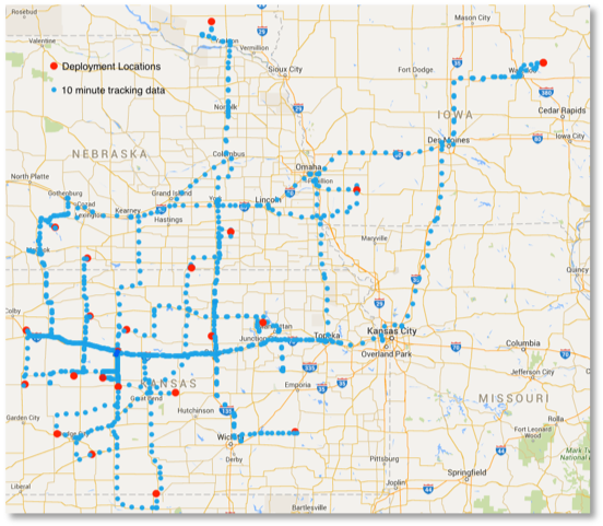
Plains Elevated Convection at Night (PECAN)
2015-06-01 to 2015-07-05
Organizer: NSF
Location: Hays, Kansas
The PECAN (Plains Elevated Convection at Night) campaign was envisioned as a multi-agency project (NSF, NOAA, NASA, DOE) designed to advance the understanding of continental, nocturnal, warm-season precipitation. PECAN was focused on nocturnal convection in conditions over the Southern Great Plains with a stable boundary layer (SBL), a nocturnal low-level jet (NLLJ) and the largest CAPE (Convectively Available Potential Energy) located above the SBL. Thunderstorms are most common after sunset across this region in summer and much of the resulting precipitation falls from mesoscale convective systems (MCSs). Nocturnal MCSs may produce heavy rainfall; their intensity is correlated with the NLLJ. To date, an accurate prediction and an in-depth understanding of elevated convection in this environment remains an elusive goal.
Combined HSRL and Raman lidar Measurement Study (CHARMS)
2015
Organizer: DOE
Location: DOE ARM SGP site, Lamont, Oklahoma
Recent advances in both lidar retrieval theory and algorithm development demonstrate that vertically resolved retrievals using such multi-wavelength lidar measurements of aerosol backscatter and extinction can help constrain both the aerosol optical (e.g., complex refractive index, scattering, etc.) and microphysical properties (e.g., effective radius, concentrations) as well as provide qualitative aerosol classification. Based on this work, the NASA Langley Research Center (LaRC) HSRL group developed automated algorithms for classifying and retrieving aerosol optical and microphysical properties, demonstrated these retrievals using data from the unique NASA/LaRC airborne multi-wavelength HSRL-2 system, and validated the results using coincident airborne in situ data. The CHARMS data set was collected to attempt similar retrievals using ground-based lidar data at SGP.
Lake Michigan Ozone Study (LMOS)
May – June 2017
Organizers: NASA, NOAA, NSF
Location: Sheboygan, Wisconsin
The 2017 Lake Michigan Ozone Study (LMOS 2017) was a collaborative, multi‐agency field study of ozone chemistry and meteorology along the Wisconsin‐Illinois Lake Michigan shoreline using a combination of aircraft, ground‐based and ship‐based measurements. The Lake Michigan region has persistently high ozone concentrations that are impacted by complex meteorology and significant transport of pollutants. The overall goal of the study was to better understand ozone formation and transport around Lake Michigan to assist researchers and air quality managers who study, predict, and manage ozone concentrations in the region. Two particularly challenging study areas are understanding the factors that determine the size, location, timing, and intensity of ozone-rich air masses, and understanding the details of the chemistry and meteorology that create the sharp gradients in ozone concentrations often observed between the lakeshore and nearby inland locations.The collection of measurement assets deployed is conceptually illustrated on the right.
Field activities were conducted from May 22‐June 22, 2017 and included two aircraft (one for remote sampling and one for in situ profiling), two ground based super sites (Sheboygan, WI and Zion, IL) outfitted with remote sensing and in situ measurements, three mobile sampling platforms measuring lakeshore‐inland ozone concentration gradients or conditions on the lake surface, and additional ground‐based remote sensing instruments collocated at several other shoreline monitoring locations. Air quality and meteorological forecasts provided flight planning guidance and in‐field evaluation of model prediction skill during the study.
Land – Atmosphere Feedback Experiment (LAFE)
August 2017
Organizer: DOE
Location: DOE ARM SGP site, Lamont, Oklahoma
The Land-Atmosphere Feedback Experiment (LAFE) will deploy several state-of-the-art scanning lidar and remote sensing systems to the ARM Climate Research Facility Southern Great Plains Megasite (SGP). These instruments will augment the ARM instrument suite to collect a data set for studying feedback processes between the land surface and the atmosphere. The novel synergy of remote sensing systems will be applied for simultaneous measurements of land-surface fluxes as well as horizontal and vertical transport processes in the atmospheric convective boundary layer (CBL). The impact of spatial inhomogeneities of the soil-vegetation continuum on land surface atmosphere (LSA) feedback will be studied using the scanning capability of the instrumentation.
Propagation of Intra-Seasonal Tropical Oscillations (PISTON)
2018-2019
Organizer: Office of Naval Research
Location: South China Sea
While numerous tropical intra-seasonal oscillations exist, PISTON will primarily target the Boreal Summer Intraseasonal Oscillation (BSISO). The BSISO defines the northward and eastward movement of the Asian monsoon during northern-hemispheric (boreal) summertime. This oscillation has been observed to impact weather across the Maritime Continent and into the southeastern portions of continental Asia, and even weather within the United States. The BSISO is rather complex, and PISTON is therefore an extensive field campaign, involving both intensive numerical modeling and observational activities. Namely, the PISTON campaign emphasizes two scientific questions:
- How do localized features such as island orography and individual thunderstorms influence tropical intraseasonal oscillations?
- How does variability in large-scale atmospheric circulations over the South China Sea influence the diurnal cycle, synoptic systems, and interactions between the atmosphere and ocean within the Maritime Continent?
Chequamegon Heterogeneous Ecosystem Energy-balance Study Enabled by a High-density Extensive Array of Detectors (CHEESEHEAD)
2019-06-24 to 2019-10-11
Organizer: NSF
Location: Park Falls, Wisconsin
The Chequamegon Heterogeneous Ecosystem Energy-balance Study Enabled by a High-density Extensive Array of Detectors (CHEESEHEAD) is an intensive field campaign designed specifically to address long-standing puzzles regarding the role of atmospheric boundary-layer responses to scales of spatial heterogeneity in surface-atmosphere heat and water exchanges. A high-density observing network will be coupled to large-eddy simulation experiments to advance spatiotemporal scaling methods for heterogeneous land surface properties and fluxes, evaluate realistic large eddy simulations in complex landscapes, and test theories on the scales at which the lower atmosphere responds to surface heterogeneity. The proposed experiment generates knowledge relevant to many scientific applications in the national interest such as numerical weather prediction, energy resources, and computational fluid dynamics. Field support outreach and teacher training is included via middle, high school, and undergraduate student involvement at nearby schools and colleges.
Tracking Aerosol Convection Interactions Experiment (TRACER)
2022-06-01 to 2022-09-30
Organizer: DOE
Location: Houston, Texas
During the TRacking Aerosol Convection interactions ExpeRiment (TRACER), scientists will use the first ARM Mobile Facility (AMF1), the second-generation C-Band Scanning ARM Precipitation Radar (CSAPR2), and a small satellite (ancillary) site with radiosonde and aerosol measurements to learn more about cloud and aerosol interactions in the deep convection over the Houston, Texas, area.
The Houston region offers a unique environment where isolated convective systems are common and experience a spectrum of polluted aerosol conditions from urban and industrial areas. In addition, surrounding areas also show significantly lower background aerosol concentrations.
TRACER also will include a four-month intensive operational period (IOP). A climatological analysis of radar observations from the Houston/Galveston-area NEXRAD (KHGX) shows that convective initiation occurs in this area on 40 to 55 percent of the days each month of the year. The total number of convective events is strongly peaked during the months of June through September. To capture these events, the TRACER IOP will run from June 1 to September 30, 2022.
Moisture and Aerosol Gradients / Physics of Inversion Evolution (MAGPIE)
2023 to 2025
Organizer: ONR
Location: Barbados
Nearly all aspects of marine atmospheric boundary layer (MABL) structure variability are strongly influenced by vertical and horizontal gradients in water vapor, temperature and turbulent mixing magnitude and structure that are controlled in part by atmospheric inversions. Practically, inversions create trapping or sharp discontinuities in atmospheric refractive index, influence aerosol hygroscopic growth and scintillation, and determine many of the properties of marine boundary layer clouds. To date, the fundamental physics and dynamics of clouds and its relationship to inversion lifecycle have not been fully connected to the regulation of energy exchange between the 1) ocean mixed layer, 2) atmospheric mixed layer, and 3) free troposphere. Such an understanding is required to understand where and when air-sea interaction assumptions and numerical parameterizations break down, leading towards work to improve prediction of maritime boundary layer structure and clouds.
This DRI will focus on the linchpin problem of how cloud related atmospheric exchange and radiation processes regulate the inversion lifecycle and affect coupled marine boundary layer and ocean processes. Two international field campaign components in different inversion environments are planned (with alternative domestic environments identified as fallbacks). Research ship and aircraft time leveraging ONR’s Code 321 UNOLS Research Facilities support will be used and refined with the MAGPIE PI team.
Enhancing Undergraduate Education of the Planetary Boundary Layer during the 2024 Solar Eclipse
2024-04-04 to 2024-04-08
Organizer: NSF
Location: Indiana
April 8, 2024 was the largest single mass migration of people in the US as millions flocked to the path of totality for the solar eclipse, and the SPARC facility was not one to be left-out. The SSEC Portable Atmospheric Research Center (SPARC) set up at Earlham College in Richmond, Indiana, where we experienced 3 minutes and 52 seconds of darkness during the total solar eclipse. In addition to witnessing this awe-inspiring phenomenon, SSEC scientists collected an extensive dataset of atmospheric boundary layer observations, to learn about the effect of the sun on the atmosphere during this unique experiment.
A total solar eclipse is akin to a sunset that occurs much more rapidly and at the wrong time of day. Our observations of the atmosphere during the eclipse allow us to study the effect of solar radiation – in isolation – on the evolution of the boundary layer and the formation of clouds. In the SPARC we deployed the AERI spectrometer, two lidar instruments and a surface meteorology station to make remote sensing observations of the structure of temperature, water vapor and winds in the atmosphere, as well clouds, aerosols and other properties. These were complemented by launches of radiosondes (weather balloons) and drone flights for in situ profiles of temperature, water vapor and winds in the atmosphere.
The SPARC is and NSF Community Instrument Facility, which means that any university investigator can request to use the facility by writing a proposal to NSF. Kevin Goebbert, Professor of Meteorology at Valparaiso University in Indiana led the successful effort to request to use the SPARC facility for this experiment. Prior to the eclipse, the SPARC visited Valparaiso University where undergraduate meteorology students were able to get hands-on experience with the SPARC and atmospheric observing instrumentation and contribute to planning the observations for the eclipse. Furthermore, participants of the Great Lakes Meteorology Conference as well as community members in Valparaiso were able to tour the SPARC and learn about atmospheric science.
With this dataset of atmospheric observations from the eclipse, Prof. Goebbert’s class and SSEC scientist will analyze the data, and hope that we learn something new about atmospheric processes, which can then allow us to improve our forecast models.
Learning by Doing: Observing the Lake Michigan Lake-Breeze Circulation
2024-04-29 to 2024-05-03
Organizer: NSF
Location: Milwaukee, Wisconsin
The weather and climate of southeast Wisconsin are significantly moderated by Lake Michigan. This influence is manifest during the cold season through lake-effect precipitation and a later first-freeze, earlier last-freeze, and milder temperatures. During the warm season, this influence is primarily manifest through the lake-breeze circulation.
Lake-breeze circulations and atmospheric observation methods are integral parts to two courses in the University of Wisconsin-Milwaukee’s Atmospheric Science program: an upper-division undergraduate and graduate elective in mesoscale meteorology (Atm Sci 460/460G) and a required upper-division undergraduate course in radiation and remote sensing (Atm Sci 511). In Atm Sci 460/460G, students engage with conceptual overviews of and basic mathematical frameworks underpinning density currents and lake- and sea-breeze circulations. However, students do not currently have the opportunity to directly connect these frameworks to observations. In Atm Sci 511, students engage with the theoretical basis for the most-common atmospheric remote-sensing platforms, particularly Doppler radar and geostationary satellite visible and infrared imagers. However, due to our program’s limited resources, students do not currently have the opportunity to directly engage with atmospheric instrumentation at the same time at which they are learning about the relevant sensing theories.
To jointly address existing gaps in our understanding of lake-breeze circulations and to improve teaching and learning for students in the University of Wisconsin-Milwaukee’s Atmospheric Science program, the University of Wisconsin-Madison’s SSEC Portable Atmospheric Research Center (SPARC; Wagner et al. 2019) and its associated instrumentation was deployed to the University of Wisconsin-Milwaukee over a two-week period in late April and early May 2024.
Collaborative Research on Complex Urban Systems (CROCUS)
2024 to 2025
Organizer: DOE
Location: Chicago, Illinois
CROCUS is an Urban Integrated Field Laboratory led by the U.S. Department of Energy’s (DOE) Argonne National Laboratory in partnership with academic and community organizations and civic and industry champions.
Funded by the DOE’s Office of Science, Biological and Environmental Research program, CROCUS studies urban climate and its implications for the Chicago region. The CROCUS team conducts novel, multi-scale observational science and creates highly accurate climate models. This information leads to new insights on extreme weather, supports the development of applicable tools and informs future actions for economic prosperity, human health, infrastructure and overall quality of life in Chicago and across the country.
Lake-induced Inversion Trapping of Emissions on the Superior Coast (LITESC)
2024-10-10 to 2024-10-24
Organizer: NSF
Location: Michigan Upper Peninsula
The SPARC facility was deployed to L’Anse, Michigan in October 2024 for a Track 1 education and outreach project aimed at understanding lake-induced inversion effects on pollutant dispersion in the atmospheric boundary layer. The project provides training and field experience to atmospheric sciences and environmental engineering undergraduate and graduate students from Michigan Technological University and UW-Madison. These students assisted in investigating the influence of temperature inversions on the air quality of the community of L’Anse, Michigan located on the southern shore of Lake Superior in Keweenaw Bay and adjacent to the Keweenaw
Bay Indian Community (KBIC) reservation. L’Anse is the home of a wood, paper, plastics, and tire-derived fuel (WPPT) waste-to-energy plant. In addition, community households burn wood for heating in the colder months of the year. Community members are concerned that the emissions from the WPPT facility and wood burning impact air quality. The impacts can be exacerbated during temperature inversions along coasts of the Great Lakes, where water temperature can at times be less than the air temperature leading to a shallower boundary layer, and consequently lessened pollutant dispersion.
Westcoast & Heartland Hyperspectral Microwave Sensor Intensive Experiment (WHyMSIE)
2025 October – November
Organizer: NASA
Location: Mead, Nebraska
WHyMSIE is the very first step forward towards an integrated, intelligent, and affordable PBL observing system of systems. It will bring together multiple observing nodes – i.e., space, suborbital, and ground – from passive and active sensors to enable a comprehensive and coherent picture of essential PBL thermodynamic variables such as temperature, water vapor, height, and hydrometeors to provide new understanding of the PBL that is not possible with any single sensor, observational approach, or scale.
Through a partnership between NASA and NOAA, this field campaign will demonstrate the first-of-its-kind hyperspectral microwave airborne measurements (CoSMIR-H) and will be complemented by other passive (infrared, visible) and active (lidar) sensors onboard the NASA ER-2 aircraft. Serving as a future NASA planetary boundary-layer (PBL) mission prototype, WHyMSIE aims to capture a wide variety of thermodynamic, moisture, and PBL regimes across a variety of surface types. The ER-2 will be flying over a variety of land and ocean environments. Over land, the aircraft will maximize validation opportunities by overflying radiosonde launch sites as well as locations with PBL relevant ground-based in situ and remote sensing measurements. We will overflying the ARM Southern Great Plains (SGP) Central Facility (CF) with high frequency ensure maximum scientific value for understanding and validating the retrieved temperature and water vapor profiles from the WHyMSIE instrument payload. Over water, we aim to capture a wide range of temperature and water vapor conditions, with a specific focus on clear sky scenes for high quality comparisons with program of record (POR) satellite instruments (e.g. ATMS, AMSU). Comparing hyperspectral microwave retrievals from CoSMIR-H with in situ temperature and humidity information will allow for scientific advancement of remote-sensing techniques into the hyperspectral microwave era and improved understanding of the PBL at different measurement scales.