Proxy
PFAAST
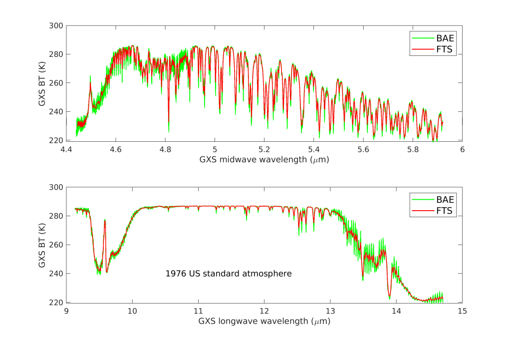
The modernized (in FORTRAN 90) PFAAST (Pressure layer Fast Algorithm for Atmospheric Transmittances) model package is an SSEC in-house fast radiative transfer model for satellite infrared radiance simulation. PFAAST offers users various capability to study and prepare for the GXS, including simulating GXS radiances before the official CRTM coefficients are available, flexibility for sensor tradeoff studies, using different radiative transfer models for simulation and assimilation in OSSE studies. PFAAST contains two software packages. One computes regression coefficients from the PFAAST algorithm. The coefficients are available in both netcdf and binary format. And the other package runs the fast transmittance model and outputs clear sky brightness temperatures and Radiance for 6 standard atmospheric profiles with a user selected 6 local zenith angles. The purpose of this package is user friendly and easy to use so that anyone can run PFAAST end to end. Follow the README file for testing. Please find the package here. Contact Chia Moeller if you have any questions/comments/suggestions. The figures below show the simulated GXS brightness temperature spectrum using the spectral response functions from an FTS based on PORD baseline version 1.0 and vendor release (BAE, see below).

GXS proxy datasets
GXS Spectral Response Functions (SRFs)
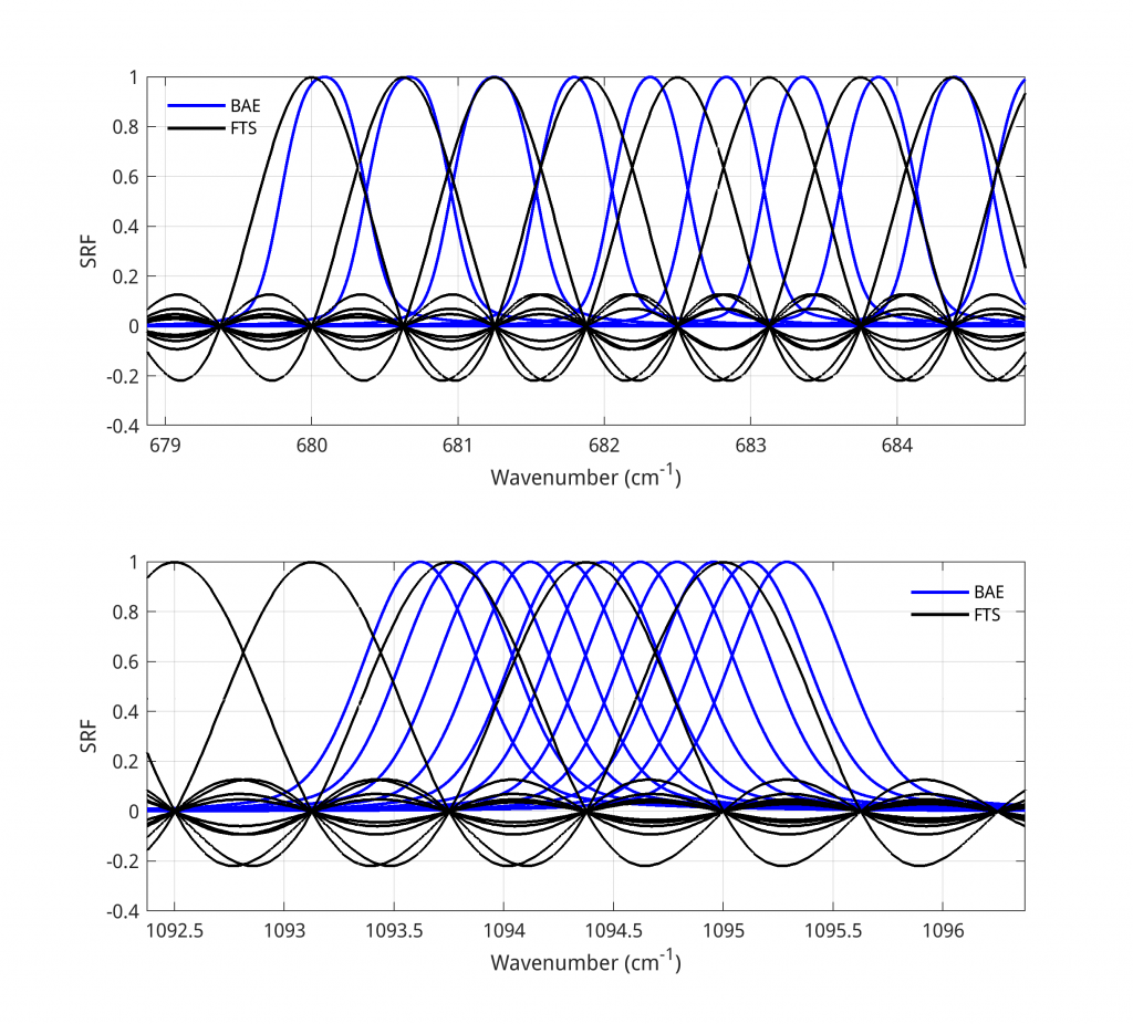
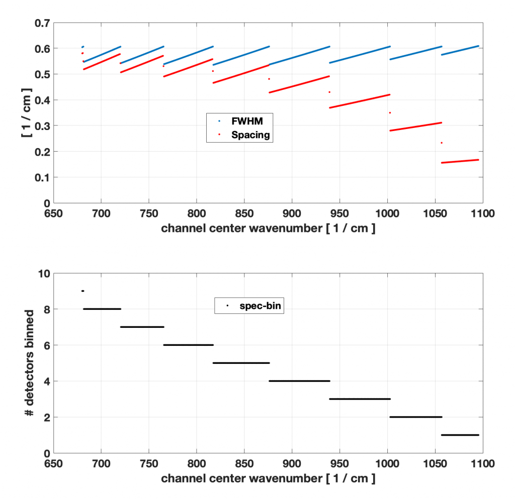
The prototype GXS binned relative spectral response (RSR) functions (SRF for each channel normalized to a maximum value of 1) provided by the vendor (BAE Systems) are available in Matlab format for longwave (access) and midwave (access). These are not final or measured SRFs. They are for modeling purposes only. Any feedback would be greatly appreciated. Please send feedback to David Johnson david.g.johnson@nasa.gov (GXS flight scientist). The figures below show selected longwave GXS SRFs in comparison to the FTS (spectral resolution of 0.625cm-1), along with the SRF FWHM, channel center spacing, and number of spectral bins for longwave channels.
The prototype GXS spectral response functions from BAE for selected longwave channels (blue lines). The black lines show the FTS sepctral response functions constructed from PORD Baseline Version 1.0 with a spectral resolution of 0.625cm-1 (Credit: Zhenglong Li).

The FWHM and channel center spacing for longwave channels (top) and the number of spectral detectors binned (bottom) (Credit: Dave Tobin).
Simulated GXS dataset
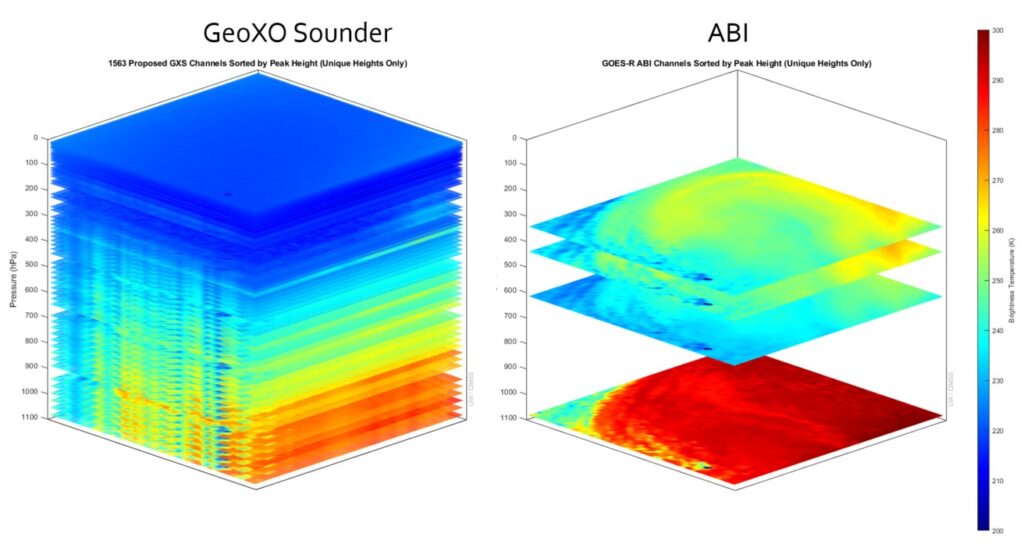
CIMSS has created proxy datasets for GXS, including 158 hours for continental United States (CONUS) and 18 hours for Sounding Disk (SD). Both CONUS and SD datasets are available every 15 minutes with a nadir resolution of 4km and the satellite located at -105 Deg. The datasets are in NetCDF format, variables include T, Q, U, V, skin temperature, emissivity, surface pressure, cloud fraction, latitude, longitude, satellite zenith and azimuth angles, solar zenith and azimuth angles, all sky brightness temperature, observation noise, cloud top pressure, cloud optical thickness, cloud particle size, and phase.
The ECMWF Experimental nature run at global 1-km resolution (XNR1K) generated by Oak Ridge Leadership Computing Facility (OLCF) at Oak Ridge National Laboratory is used to provide the information of atmosphere, surface and clouds as input for RTM. XNR1K is available every 15 minutes.
The proxy datasets can be used for many qualitative and quantitative applications of GXS radiances, such as finding spectral signals of special weather phenomenons (thin clouds, low clouds, deep convective clouds, temperature inversion, severe storm rapid development etc), testing retrieval algorithms for temperature, moisture, winds, and clouds, as well as application to nowcasting.
For more information about the GXS proxy datasets, please refer to the 2025 AMS presentation.
Two versions of proxy datasets have been created. Version 1 (V1) assumes an FTS while Version 2 (V2) uses the prototype SRF provided BAE. For both versions, 4 cases are available:
1 full disk of 18 hours from 12:00 UTC on Sep 6 2019 to 5:30 UTC on Sep 7 2019
First CONUS cases of 45 hours from 00:15 UTC on Sep 6 2019 to 20:45 UTC on Sep 7
Second CONUS cases of 36 hours from 12:15 UTC on Aug 18 2019 to 23:45 UTC on Aug 19
Third CONUS cases of 72 hours from 00:15 UTC on Sep 20 2019 to 23:45 UTC on Sep 22
To test the GXS proxy datasets:
One full disk sample file of V2 can be found here
One CONUS sample file of V2 can be found here
Please contact Zhenglong Li for complete proxy datasets.
Observed NAST-I dataset
The National Airborne Sounder Testbed-Interferometer (NAST‑I) has been successfully operating on high altitude aircraft since 1998. NAST‑I onboard NASA high-altitude research aircraft serves as a spaceborne instrument simulator. NAST-I, maintained and deployed by LaRC NAST-I team, is one of NASA facility instruments of the Airborne Science Program within the NASA Earth Science Division. The NAST‑I is an airborne FTS remote sensor that nominally flies on NASA high-altitude aircraft (https://airbornescience.nasa.gov/instrument/NAST-I) to provide high resolution spectrally-resolved infrared radiances as its level-1 product. NAST-I level-2 products characterizing the surface (i.e., skin temperature and spectral emissivity), atmosphere (i.e., profiles of temperature, moisture, ozone, carbon monoxide, and other trace species), and clouds (e.g., optical depth, particle size, temperature, and height) can be used to support scientific analyses in support of Earth system science advancement. NAST-I team performs scientific analyses which is further benefited from implementing a set of internal algorithms for fast radiative transfer modeling and geophysical product retrievals. NAST-I has participated in 20+ field experiment campaigns since program inception (1998), including the recent FIREX-AQ field campaign in the summer of 2019 focused on characterizing wildfire emissions and their impact on air quality and climate. Program activities have had an airborne field campaign centric focus with broader benefits contributing to global satellite programs and research for many high-priority NASA science interests (e.g., air quality, wildfires, PBL, weather, and climate). NAST‑I provides high-spatial linear resolution equal to 13% of the aircraft altitude at nadir (2.6 km FOV on the ground from an ER‑2 altitude of 20 km) and 13 FOVs across the aircraft track from 13 NAST‑I scan angles (~3.4 km apart on the ground from an ER‑2 altitude of 20 km). NAST‑I spatially scans and provides high-spectral resolution (0.25 cm-1) measurements within the spectral region of 645–2700 cm‑1. It serves as an ideal validation sensor since it measures the same Level-1 data product as many of the sensors it helps to validate (i.e., infrared spectral radiance) and does so at higher spectral and spatial resolutions. NASA Langley Research Center analysis is further benefited by implementing a set of internal algorithms to enable an independent assessment of derived Level-2 products. Airborne field campaigns are generally designed to allow retrieval algorithm enhancements and validation with a set of rich coincidental measurements from other sensors.
Both NAST-I Level-1 (radiances) and level-2 (retrievals) are available on NASA BOX (https://nasagov.account.box.com/login) for GXS proxy studies; to access the NAST-I data, please contact Dan Zhou at daniel.k.zhou@nasa.gov.
Observed S-HIS dataset
The University of Wisconsin-Madison Space Science and Engineering Center (UW-SSEC) Scanning High-resolution Interferometer Sounder (S-HIS, https://shis.ssec.wisc.edu ) measures emitted thermal radiation at high spectral resolution (0.5 cm-1) between 3.5 and 17.3 microns (580 – 2850 cm-1) with 0.1 radians angular field of view (e.g., 2km footprint at nadir from a 20km observing altitude, 500m footprint at nadir from a 5km observing altitude) and scene imaging accomplished via cross-track scanning. Since 1998, the S-HIS has participated in 37 field campaigns on the NASA ER-2, DC-8, Proteus, WB-57, and Global Hawk airborne platforms. The S-HIS has proven to be extremely dependable, with high calibration accuracy and consistent performance on all platforms. S-HIS quality-controlled data yield is typically above 99% for flight science data collection. The S-HIS has a well-established role as an airborne reference instrument for satellite instrument calibration validation [Taylor et al. 2023]. For the calibration validation process to be accurate, traceable, and repeatable, it is important that the reference data instrument be extremely well characterized and understood, provide operationally robust high-yield observations to ensure full spatial coverage of the satellite observations being validated, and be accurately calibrated with strong traceability to absolute standards. The S-HIS meets and surpasses these requirements and has proven to do so consistently on multiple airborne platforms, each with significantly different instrument operating environments. Other S-HIS measurement applications have included radiances for evaluating radiative transfer models, temperature and water vapor retrievals, cloud radiative properties, cloud top retrievals, surface emissivity and temperature, trace gas retrievals, and planetary boundary layer studies. S-HIS is highly valuable in field programs where this extensive range of properties (highly accurate radiance spectra, temperature and water vapor profile distributions, cloud and surface radiative properties, and trace gas amounts) is needed with higher spatial resolution and better temporal overlap than can be provided by satellite sounding instruments, and where more extensive coverage is needed than in situ observations can provide.
S-HIS Level 1B (calibrated and geolocated radiances) and Level 2 Dual Regression with De-Aliasing (DRDA) retrievals [Smith et al. 2012 and 2018] for recent missions are available for GXS proxy data usage, via the SSEC http and ftp servers:
http: https://bin.ssec.wisc.edu/pub/shis/noindex/903itlg/gxs/
ftp: ftp://ftp.ssec.wisc.edu/pub/shis/noindex/903itlg/gxs/
Please contact Joe Taylor (joetaylor@wisc.edu) for questions regarding the data, or to request S-HIS data from other missions.
Taylor, Joseph K., David C. Tobin, Fred A. Best, Raymond K. Garcia, Michelle L. Loveless, Henry E. Revercomb, and William L. Smith Sr. “High-altitude aircraft radiometric calibration-validation campaigns.” In Field Measurements for Passive Environmental Remote Sensing, pp. 159-184. Elsevier, 2023. (link)
Smith Sr, W. L. and Weisz, E., “7.09 – Dual-Regression Approach for High-Spatial-Resolution Infrared Soundings,” in Comprehensive Remote Sensing, Shunlin Liang, Ed., ed Oxford: Elsevier, 2018, pp. 297-311. (link)
Smith, William L., Elisabeth Weisz, Stanislav V. Kireev, Daniel K. Zhou, Zhenglong Li, and Eva E. Borbas. “Dual-regression retrieval algorithm for real-time processing of satellite ultraspectral radiances.” Journal of applied meteorology and climatology 51, no. 8 (2012): 1455-1476. (link)
Proxy studies
The added value of hyperspectral IR sounders have been demonstrated in many studies using proxy data. Menzel et al 2018 summarized the history and discussed the applications of of satellite based sounders, including hyperspectral IR sounders. Listed below are some studies of hyperspectral IR sounders using proxy data.
Blaylock, B., Tyndall, D., and Pauley, P., 2024: Assimilation of EUMETSAT IASI 3D wind product in the Navy Global Environmental Model, 28th Conference on Integrated Observing and Assimilation Systems for the Atmosphere, Ocean, and Land Surface, 104th AMS annual meeting, Baltimore, MD, 28 January – 2 February 2024. (link)
, 2018: Satellite-Based Atmospheric Infrared Sounder Development and Applications. Bull. Amer. Meteor. Soc., 99, 583–603, https://doi.org/10.1175/BAMS-D-16-0293.1
F. Iturbide-Sanchez et al., “Exploration of a Future NOAA Infrared Sounder in Geostationary Earth Orbit,” in IEEE Journal of Selected Topics in Applied Earth Observations and Remote Sensing, vol. 15, pp. 1543-1561, 2022, doi: 10.1109/JSTARS.2022.3142069.
Tropical cyclone forecast improvement (Radiances or Retrievals)
With its high spectral resolution, GEO hyperspectral IR sounders will have the resolving power to better characterize the vertical changes in atmosphere, as demonstrated by many studies with polar orbiting satellites.
Wang Pei, Jun Li, Z. Li, A. H. N. Lim, Jinlong Li, T. J. Schmit, and M. D. Goldberg, 2017: The Impact of Cross-track Infrared Sounder (CrIS) Cloud-Cleared Radiances on Hurricane Joaquin (2015) and Matthew (2016) Forecasts, Journal of Geophysical Research – Atmospheres, 122, DOI: 10.1002/2017JD027515. (link)
Li, Jun, P. Wang, H. Han, J. Li, and J. Zheng, 2016: On the assimilation of satellite sounder data in cloudy skies in the numerical weather prediction models, Journal of Meteorological Research. 30, 169-182.(link)
Wang, P., Jun Li, M. Goldberg, T. J. Schmit, et al., 2015: Assimilation of thermodynamic information from advanced IR sounders under partially cloudy skies for regional NWP, Journal of Geophysical Research – Atmosphere, 120, doi:10.1002/ 2014JD022976. (link)
Wang, Pei, Jun Li, Jinlong Li, Zhenglong Li, Timothy J. Schmit, and Wenguang Bai, 2014: Advanced infrared sounder subpixel cloud detection with imagers and its impact on radiance assimilation in NWP, Geophysical Research Letters, 41, 1773 – 1780. (link)
Zheng, J., Jun Li, T. J. Schmit, Jinlong Li, and Z. Liu, 2015: The impact of AIRS atmospheric temperature and moisture profiles on hurricane forecasts: Ike (2008) and Irene (2011). Advances in Atmospheric Sciences, 32, 319 – 335 . (link)
Liu, H., and J. Li, 2010: An improved in forecasting rapid intensification of Typhoon Sinlaku (2008) using clear-sky full spatial resolution advanced IR soundings, J. Appl. Meteorol. and Cli., 49, 821 – 827. (link)
Li, J., H. Liu, 2009: Improved Hurricane Track and Intensity Forecast Using Single Field-of-View Advanced IR Sounding Measurements, Geophysical Research Letters, 36, L11813, doi:10.1029/2009GL038285. (link)
Short-term forecasting and nowcasting applications (AIRS, IASI, ABI and AHI)
The unique advantage of GEO, the high temporal resolution, allows nearly continuous observation of the atmosphere and earth surface, providing critically important information for short-term forecasting and nowcasting applications (i.e. local severe storms).
, , , , , , Li, J., Li, Z. (2022). The Potential Value of Combining Assimilation of Water Vapor Radiances and Cloud Liquid/Ice Water Path from ABI on Analyses and Forecasts for Hurricane Irma (2017). Journal of Geophysical Research: Atmospheres, 127, e2022JD036910. https://doi.org/10.1029/2022JD036910
Li, Z., Ma, Z., Wang, P., Lim, A. H. N., Li, J., Jung, J. A., et al. (2022). An objective quality control of surface contamination observations for ABI water vapor radiance assimilation. Journal of Geophysical Research: Atmospheres, 127, e2021JD036061. https://doi.org/10.1029/2021JD036061
Feng, J., Huang, Y., and Qu, Z.: A simulation-experiment-based assessment of retrievals of above-cloud temperature and water vapor using a hyperspectral infrared sounder, Atmos. Meas. Tech., 14, 5717–5734, https://doi.org/10.5194/amt-14-5717-2021, 2021.
Feng, J., Huang, Y., and Qu, Z.: An observing system simulation experiment (OSSE)-based assessment of the retrieval of above-cloud temperature and water vapor using hyperspectral infrared sounder, Atmos. Meas. Tech. Discuss. [preprint], https://doi.org/10.5194/amt-2020-518, 2021.
, 2017: Satellite Radiance Data Assimilation within the Hourly Updated Rapid Refresh. Wea. Forecasting, 32, 1273–1287, https://doi.org/10.1175/WAF-D-16-0215.1
, 2017: Radiance Preprocessing for Assimilation in the Hourly Updating Rapid Refresh Mesoscale Model: A Study Using AIRS Data. Wea. Forecasting, 32, 1781–1800, https://doi.org/10.1175/WAF-D-17-0028.1
Lee, Yong-Keun, Jun Li, Zhenglong Li, and Tim Schmit, 2017: Atmospheric temporal variations in the pre-landfall environment of Typhoon Nangka (2015) observed by the Himawari-8 AHI, Asia-Pacific Journal of Atmospheric Sciences. DOI:10.1007/s13143-017-0046-z. (link)
Bojkov, Bojan R., 2017: Product plans and science applications for MTG-IRS, ECMWF/EUMETSAT Workshop on Assimilation of Hyper-spectral Geostationary Satellite Observations, Reading, 22-25 May 2017. (link)
Li, J., C.-Y. Liu, P. Zhang, and T. J. Schmit, 2012: Applications of Full Spatial Resolution Space-Based Advanced Infrared Soundings in the Preconvection Environment, Weather and Forecasting, 27, 515 – 524. (link)
The GOES/GOES-16 LAP products have been demonstrated at HWT 2015, 2016, 2017, and 2018. Feedback from forecasts include:
- Very useful LAP products with high temporal and spatial resolutions;
- Temporal and spatial gradients are more important;
- Current product has only three layers, more vertical layers are needed, which means GEO advanced IR sounder data are needed
Improved surface skin and boundary temperature
Often the timing and location of severe convective storms depends on the location and timing of the erosion of the capping temperature inversion in the lower troposphere. Smith et al. (2019) have shown that the combination of polar hyperspectral IR sounder information with surface and RAP forecast data can resolve the vertical details of this capping inversion very well. More information about this study can be found at here. The high temporal resolution of geostationary hyperspectral sounding data will help observe and forecast the time change and location of this capping inversion, and diagnose where and when tornadic storms will develop.
Atmospheric motion vector (AMV)
The AMV is a perfect example to take good advantage of the high temporal resolution from GEO. AMV has been a legacy product of the GOES series of satellites, and is a baseline product of GOES-R series. The future GEO hyperspectral IR sounder will enhance the current AMV products with much improved vertical resolution. AMV provides important wind information about troposphere, especially in area where conventional observations are limited. Below are several examples of the benefits of assimilating GEO AMVs or hyperspectral IR data into NWP models.
Blaylock, B., et al, 2024: Assimilation of EUMETSAT IASI 3D wind product in the Navy Global Environmental Model at the AMS annual meeting. https://ams.confex.com/ams/104ANNUAL/meetingapp.cgi/Paper/429566
Santek, D., Nebuda, S., & Stettner, D. (2019). Demonstration and evaluation of 3D winds generated by tracking features in moisture and ozone fields derived from AIRS sounding retrievals. Remote Sensing, 11(22), 2597. https://www.mdpi.com/2072-4292/11/22/2597
, 2017: Assimilation of High-Resolution Satellite-Derived Atmospheric Motion Vectors: Impact on HWRF Forecasts of Tropical Cyclone Track and Intensity. Mon. Wea. Rev., 145, 1107–1125, https://doi.org/10.1175/MWR-D-16-0229.1
Le-Marshall, John, et al. “Operational Generation and Assimilation of Himawari-8 Atmospheric Motion Vectors” Proceedings for the 13th International Winds Workshop, 27 June – 1 July 2016, Monterey, California, USA. (link)
Santek, D., Nebuda, S., and Stettner, D., 2014: Feature-tracked winds from moisture fields derived from AIRS sounding retrievals. International Winds Workshop, 12th, Copenhagen, Denmark, 15-20 June 2014. EUMETSAT, Darmstadt, Germany, 2014. (link)

