Superior snowfall: Study compares lake-effect snow to large snowstorms
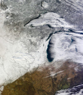
Located along the south shore of Lake Superior, Marquette, Michigan receives 8 to 16 feet of snow per year, making it a magnet for snow enthusiasts of all types, including researchers who study snow.
As it turns out, two types of storms are responsible for snowfall in Michigan’s Upper Peninsula and the Great Lakes region generally. The first takes the form of intense, localized lake-effect snowstorms that can dump several inches to several feet of snow at a time. The second, are large-scale (or synoptic) snowstorms that result from wider ranging weather systems moving across the region.
A team of researchers at the University of Wisconsin–Madison Space Science and Engineering Center have been studying snowfall near Marquette, Michigan since 2014 to tease out the differences between these two storm types. Their study analyzes four years of winter data to investigate snowfall rates and the physical characteristics of snowstorms over the area. The results of their work were published January 2020 in the Journal of Applied Meteorology and Climatology.
“The big takeaway from this study is that we identified major differences in the microphysics and the meteorology of these two kinds of snowstorms,” says SSEC scientist Claire Pettersen, lead author of this work. “Ultimately these data can be used to improve satellite retrievals and help forecasters understand differences in environmental factors that produce these snowstorms.”
The team’s analysis shows that lake-effect snow events occur twice as often as large-scale snowstorms, but each accounted for nearly equal amounts of the annual accumulation.
The Great Lakes, due to the sheer volume of water they hold, are capable of generating weather. Lake-effect snow occurs when cold air rushes over a warm body of water (like an unfrozen Lake Superior) and rapidly rises. The rising air cools and condenses into clouds which grow narrow and dense, eventually dropping precipitation over land. Large-scale snowstorms, on the other hand, are produced by the cold and warm fronts and low-pressure systems that drive everyday weather across the continent
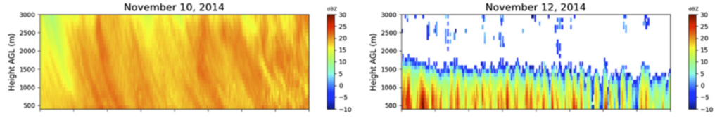
Related to overall storm structure, lake-effect storms tend to be fairly shallow, meaning they do not extend far into the atmosphere, with precipitation levelling off around 1.5 km above the ground. In contrast, large-scale snowstorms can extend upwards with precipitation detected to beyond 3 to 5 km in the atmosphere on average.
Pettersen and her colleagues took measurements using a suite of instruments located at the National Weather Service station in Marquette, Michigan. Their data are available online daily.
Relatively little observational data exists for Lake Superior and its weather patterns. Other Great Lakes like Ontario and Erie have a longer history of scientific observation. Pettersen says these long-term studies are important in order to find statistically significant differences between the weather systems and to eventually investigate trends in snowfall.

The team collected atmospheric information like temperature, humidity and pressure, as well as snowfall rates and snowflake size. A small radar, known as the Micro Rain Radar, was used to profile the storms as they passed overhead to estimate the height of the precipitation. Whereas a high-speed camera rig, built and provided by NASA, collected detailed images of snowflake sizes and was used to determine accumulation rates. Additionally, the National Weather Service office provided NEXRAD radar data, meteorological observations and measurements of snow accumulations for comparison.
Pettersen says that differences in snowflake size and shape revealed notable differences between each type of storm. Shallow, lake-effect storms tended to produce more large snow crystals with greater variations in size. However, the more homogenous synoptic storms produced fewer large ice crystals with less variation in size. Due to these observed differences, researchers think that lake-effect snow events are more variable in terms of the snow density and snow particles.
“Having these long-term data sets will help us understand the characteristics of snowfall associated with distinct weather patterns over the Great Lakes and eventually could be used for climatological and trend analysis,” says Pettersen. She and her team have already begun their seventh year of data collection at the Marquette site. “Using simple tactics, we can take something fundamental that yields good information and learn how there are differences in these storm systems.”
This research was supported by NASA and NOAA