High Noon From Geostationary Orbit
From 22,000 miles above the Earth, geostationary satellites now provide scientists the opportunity to create stunning natural color images of global weather patterns. Each global composite image is created by taking small slices of data from a geostationary satellite when the data are from local noon. As an example, a small slice of data from the United States GOES-East satellite at 1700 UTC would be chosen for local noon in New York and a small slice from the Japanese satellite, Himawari, at 0245 UTC would be chosen for local noon in Tokyo. Slices of data from 250 images, spanning a period of 24 hours, are stitched together to create a single image depicting local noon for a single day.
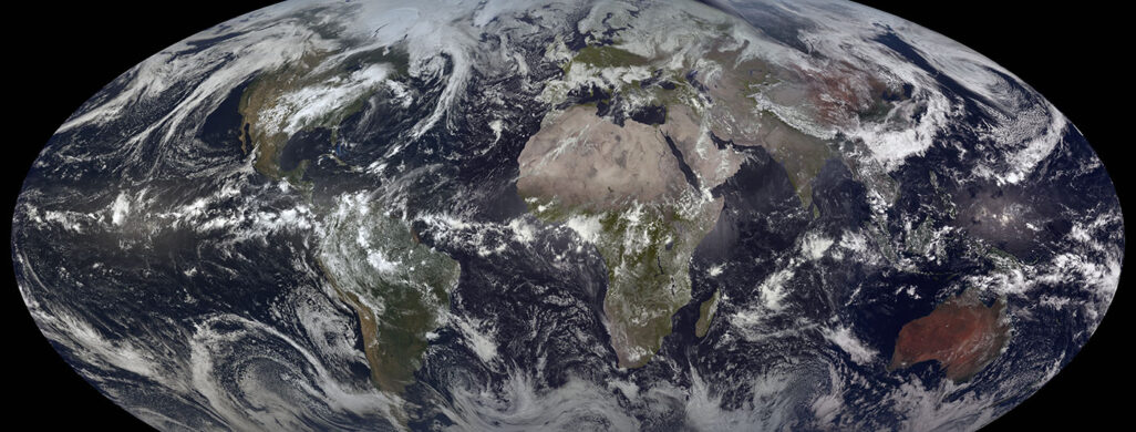
A year-long animation shows how the season change, large storms moving across regions of the earth and even hurricanes that span many days. Seasonal changes can also be seen as the North and South poles loose sunlight during winter times. A year-long animation combines over 90,000 individual images from five geostationary data, two from the United States, one from Japan and two from the European Space Agency. Small sections each image are stitched together to create daily images depicting local noon at each location on Earth.
Natural Color images from geostationary satellites have become common place on many websites including those seen on the SSEC Satellite Image Page. The images are created by combining red, green and blue wavelengths from sensors onboard the satellites. In some cases, these wavelengths are not available but can be simulated using other sensors from the satellite. On March 1st, 2018, the National Oceanic and Atmospheric Association (NOAA) launched GOES-17 completing a global constellation of five geostationary satellites providing the opportunity to create natural color “Big Blue Marble” images as seen from a geostationary orbit. The other four satellites include GOES-16, Himawari from the Japanese Meteorological Agency and both MSG satellites from the European Space Agency.
The data for these composites come from SSEC’s Satellite Data Services. An archive of individual satellite images can be downloaded using McFETCH.