Monthly News Summary – September 2007
Hurricane season ramps up with Dean and Felix
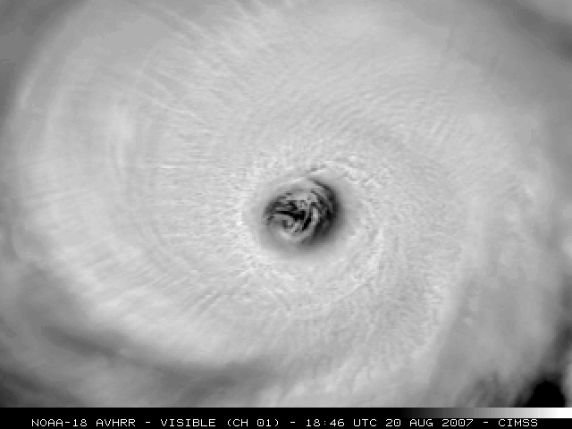
NOAA-18 provides a clear view of the eye of Hurricane Dean, the first official hurricane of the 2007 Atlantic hurricane season.
Although this year’s Atlantic hurricane season had an unusually early start in May with Tropical Storm Andrea, the summer months brought only a few storms to the Atlantic. Making landfall in late August, Hurricane Dean was the first official hurricane of the 2007 Atlantic hurricane season. Dean became a Category 5 storm as it approached Mexico. For images and details about Hurricane Dean, check out posts to the CIMSS Satellite Blog from August 18, 19, 20 and 21. The CIMSS Tropical Cyclones Research Team created many of the images and animations featured in these blog posts. This group of CIMSS researchers develops innovative techniques that use environmental satellites to monitor and study tropical cyclones. Several CIMSS products directly support forecasting efforts at the National Hurricane Center.
In early September, CIMSS satellite data products contributed to forecasts for Hurricane Felix. Felix followed shortly after Dean, making landfall on September 4 as a Category 5 storm. Chris Velden explains that a CIMSS data assimilation technique helped forecasters at the National Hurricane Center diagnose Felix’s intensity as the storm navigated the Caribbean. Developed by Veldenand Tim Olander, the Advanced Dvorak Technique (ADT) is a tool that uses satellite data to assess hurricane intensity.
Studying the tropical atmosphere in Costa Rica
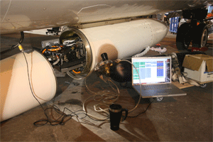
SSEC’s Scanning HIS flew on one of NASA’s high altitude aircraft to gather data for NASA’s TC4 mission in Costa Rica. The Scanning HIS fits in a pod on the aircraft.
Identifying critical atmospheric processes in the tropics is essential to the advancement of our understanding of global climate change, the depletion of ozone in the stratosphere and the chemical composition of the troposphere. SSEC recently contributed to aNASA field experiment in Costa Rica during which researchers collected information about atmospheric structure, properties and processes in the tropical Eastern Pacific.
Scientists and support crew collected data for NASA’s Tropical Composition, Cloud and Climate Coupling (TC4) mission from July 15 through August 10. The satellite observations gathered during the field experiment provide crucial information on the spatial and temporal variations of this region. Aircraft observations collected during carefully planned flights validate the satellite data and provide critical observations not available from the satellite instruments.
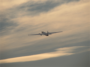
During TC4, the NASA ER-2 completed 11 science flights totaling roughly 66 science flight hours. The S-HIS collected science data for roughly 64.9 hours.
During the TC4 field program, NASA high altitude aircraft collected tropopause data while the medium altitude aircraft provided in-situ profiles and structure measurements of the tropical upper troposphere and lower stratosphere. At the conclusion of TC4, the aircraft had flown a total of 25 flights; 292 weather balloons had been launched from the Galapagos, Panama and Costa Rica; and the DC-8 had launched 93 dropsondes.
SSEC’s Scanning High-resolution Interferometer Sounder (S-HIS) was a critical component of payload aboard NASA’s high altitude ER-2. The S-HIS high spectral resolution infrared observations complement observations from two other instruments aboard the ER-2: the MODIS Airborne Simulator (MAS) and the NASA Cloud Physics Lidar (CPL).
During the TC4 mission, researchers had the chance to use the S-HIS to measure the elevated dry layer associated with the Saharan Air Layer (SAL). S-HIS sampled this region of the atmosphere on July 19 in the Caribbean Sea with measurements of upper level water vapor over the Galapagos Islands coincident with in situ validation, satellite calibration validation opportunities and retrieved levels of carbon monoxide associated with biomass burning.
In addition to the S-HIS measurements, SSEC contributed valuable satellite data visualization expertise to the TC4 mission. Of particular use for mission planning were the Tropical Cyclones Group’s Saharan Air Layer image and animation products, the Terra and Aqua MODIS quicklooks for the TC4 mission produced via the MODIS direct broadcast at the SSEC andMorphed Integrated Microwave Imagery at CIMSS – Total Precipitable Water (MIMIC-TPW) animations. The S-HIS team would like to thank those who create and support these excellent satellite data visualization products.
NASA Headquarters Atmospheric Composition Focus Area sponsored the TC4 experiment with specific contributions from the Upper Atmospheric Research Program, the Radiation Science Program and the Tropospheric Chemistry Program. SSEC’s director, Hank Revercomb, is the Principle Investigator for the S-HIS program. Fred Best is the Project Manager.
—Joe Taylor
Latest release of atmospheric data processing software package
Using IMAPP visualization software, researchers can create MODIS True Color images. The IMAPP products and images are useful in a variety of applications from forecasting weather to monitoring lakes.
Processing atmospheric observations from satellites is, as SSEC co-founder Verner Suomi explained, “like drinking from a fire hydrant.” On the ground, researchers develop software and visualization tools to use the data — tools that have grown steadily more complex with each new generation of satellite instruments. SSEC/CIMSS recently released an updated version of a software package that makes it possible for scientists around the world to drink from the fire hydrant without drowning.
CIMSS researchers have collaborated with NASA to release the latest version of a software package that facilitates the creation of science products using data from the MODerate Resolution Imaging Spectroradiometer (MODIS), an instrument aboard the polar-orbiting satellites Terra and Aqua. Available as a free download via the CIMSS website, version 2.0 ofInternational MODIS/AIRS Processing Package (IMAPP) Level 2 includes the latest versions of programs to create popular science products: cloud mask (detection), sea surface temperature, atmospheric profiles, cloud top properties, cloud phase, aerosol thickness and visible water vapor.
For this release, CIMSS researchers repackaged the software to make it easier to install and execute. They also updated the package to automatically identify and download any exterior dynamic data sets that are required to create each individual product. Also new to this release is a feature that allows users to automatically generate images in GIF and JPG formats of key output products including sea surface temperatures and atmospheric water vapor. Finally, a brand new IMAPP web page has been launched in support of the new MODIS Level 2 release.

After a few modifications, the DISC drill is on its way to Antarctica to take samples of the ice more than two miles beneath the surface.
Preparing to drill—At the end of the summer, SSEC’s Ice Coring and Drilling Services (ICDS) bade farewell to theDeep Ice Sheet Coring(DISC) drill as the drill embarked on its journey to Antarctica. This winter, an ICDS drilling crew will use the DISC drill to take samples of the ice more than two miles beneath the surface in support of the West Antarctic Ice Sheet (WAIS) Divide Ice Core Project. The core will provide a climatic record for Antarctica for the past 100,000 years with a resolution that will allow scientists to determine conditions on an annual basis for the last 40,000 years.
As described in the project’s quarterly update, the ICDS crew spent the summer modifying the drill based on the test run in Greenland last year. The winch received extensive modifications, including mechanical, electrical and software changes. ICDS engineers also altered the electronics inside the sondes and developed a new screen-cleaning system. Alex Shturmakov, manager of the DISC Drill project, says that the drilling team will be prepared for the drill’s first season in Antarctica.
Comments on climate sensors—An article in Science quoted Paul Menzel discussing the National Polar-orbiting Operational Environmental Satellite System (NPOESS). Although several sensors didn’t make cut during the program’s restructuring, Menzel pointed out that the size of the satellite hasn’t changed. The extra space could allow additional sensors to fly. Menzel also cautioned that the budget overruns limit the amount of money leftover to restore any of the cancelled sensors or to fly the sensors on other missions. NPOESS is a necessary upgrade from the nation’s current polar-orbiting weather satellite system, which has remained essentially unchanged since 1978.
Providing tools to the international community—Over the summer, Paul Menzel, Paolo Antonelli, Liam Gumley and Kathy Strabala conducted an innovative workshop in Benevento, Italy that left participants with an understanding of remote sensing concepts and the applications of such data. The workshop consisted of a lecture component and a hands-on lab portion during which participants applied the information gleaned from the lectures. Since 2001, SSEC/CIMSS has organized and partially sponsored ten similarworkshops around the world.
What time is it?—Determining what time it is in Antarctica is relatively complicated. Shelley Knuth of SSEC’s Antarctic Meteorological Research Center recently explained how to figure out the answer to that question on public radio’s Geo Quiz. According to Knuth, the South Pole and McMurdo station run on New Zealand time because doing so makes it easier to schedule flights. As for the other stations on Antarctica, the country operating the station determines the time zone.
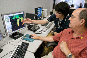
Jordan Gerth (back) helped SSEC reinvigorate an ongoing collaboration with the National Weather Service. Here, he discusses the MODIS Sea Surface Temperature image with the head forecaster at the Milwaukee forecast office.
Photo: Jeff Miller, University Communications
Support for the National Weather Service—With a shared goal of improved weather prediction, SSEC researchers have been collaborating for years with state NWS forecast offices in Milwaukee, La Crosse and Green Bay to translate weather research into more accurate forecasts. But the fresh perspective provided by Jordan Gerth, an undergraduate CIMSS researcher, helped the team give a facelift to the ongoing collaboration. Gerth figured out how to accommodate an intricate software interface used by NWS to give operational forecasters direct computer access to SSEC’s wealth of satellite meteorology resources. An article about Gerth’s work with NWS appeared in Wisconsin Week on September 5.
Gerth joined his SSEC colleagues at the NWS Great Lakes Workshop in early September. At the workshop, Gerth set up a workstation to demonstrate how to display SSEC satellite products in NWS’s Advanced Weather Interactive Processing System. Ralph Peterson, Kris Bedka,Bob Aune and Scott Bachmeier gave presentations on satellite applications for operational forecasting. Topics included methods to use products from the MODerate-resolution Imaging Spectroradiometer (MODIS) in forecasting and satellite-derived nowcasts of convective storms.
The utility of the satellite observations provided by CIMSS is evident in the NWS area forecast discussions, in which the forecasters describe the different information used to make a particular forecast as accurate as possible. On September 9, a forecast area discussion from the Milwaukee office indicated significant influence from the CIMSS Regional Assimilation System (CRAS). According to the forecast discussion, CRAS forecast images helped to clarify a complicated weather pattern so that the forecaster could generate a more reliable short-term forecast for Wisconsin.
Forecasts for China—Bob Aune has added China to the coverage of the CIMSS Regional Assimilation System (CRAS), an experimental forecast model that helps researchers to assess the impact of satellite data on a forecast. Using data from China’s weather satellite, FY-2C, the CRAS generates 72-hour forecast images.
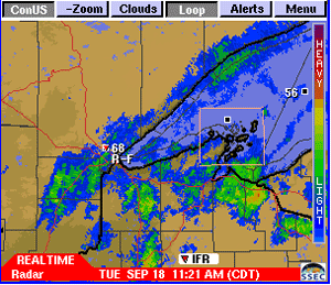
Russ Dengel recently added a radar view of the Apostle Islands, WI to the PAW online service.
PAW popularity—SSEC’s PDA Animated Weather online servicecontinues to grow in popularity. Since creatorRuss Dengel and SSEC webmaster Bill Bellondeveloped the PAW Google Gadget, more than 20,000 web surfers have visited the Gadget’s page. Recently, Dengel added local radar views of Apostle Islands, WI and Miami, FL as well as the forecast histogram for the CRAS predictions for Madison, WI and daily true color MODIS images.
Aviation weather—NASA recently launched a web site for a collaborative research effort that focuses on aviation applications for satellite data products–Advanced Satellite Aviation weather Products (ASAP). Led byWayne Feltz, a group of CIMSS scientists contributes to this effort. The NASA web site prominently features CIMSS data and research including the pages on volcanic ash, turbulence and convective weather. For more information about SSEC/CIMSS aviation weather research, visit the web page for the Satellite-based Nowcasting and Aviation Application Program.
Recently published paper—Geophysical Research Letters recently published a paper on hyperspectral IR surface emissivity retrievals. Jun Li,Jinlong Li and Elisabeth Weisz co-authored the paper titled “Physical retrieval of surface emissivity spectrum from hyperspectral infrared radiances.”