Monthly News Summary – May 2004
Applets Make Weather Come Alive
This issue of SSEC In the News covers news and research results primarily from March and April 2004. Use images freely with credit to the Space Science and Engineering Center, University of Wisconsin–Madison, but please notify SSEC’s Public Information Officer. Individual photographers retain copyright; contact them or me to use a photo. Writers for this issue are both Alexis Johnson and Terri Gregory.
Steve Ackerman and Tom Whittaker’s work at the University of Wisconsin–Madison to make weather come alive using simple Java software applications is receiving attention. The work was featured inWisconsin Week (March 10) in the “Faculty Corner” of an insert devoted to computing. Ackerman, who directs the Cooperative Institute for Meteorological Satellite Studies, teaches meteorology in the Department of Atmospheric and Oceanic Sciences. In the early 1990s he approached software programmer Tom Whittaker (also with SSEC’s CIMSS) for ways to enliven his introductory meteorology classes. Since then the two have developed about two dozen Java applets to visualize climate and weather.
Now they are being honored for their hard work. They are nominated for a Pixie Award, which “honors achievement in online and broadband motion picture production.” The nomination is often considered the Internet’s equivalent to the Academy Awards. The Why Files is nominated under the category that honors “web design incorporating motion” for a series of interactive animations that allows users to play with lightning, build a tornado, make snowflakes and hit a baseball. University Communications announced the nomination on March 19, and in the Wisconsin Week Wire, March 24. Their interactive tornado simulation(click on 3) was featured in www.4kids.org, a compilation of Web “tecKNOWLEDGEy” that is syndicated in the color comics section of many U.S. Sunday newspapers. We found it in the March 31 edition of theJournal News for West Chester, Rockland and Putnam, New York counties. The Why?Files, where science is presented in a friendly, interesting way, is produced at UW–Madison by University Communications and is funded by the National Science Foundation.
Agricultural Science
Work in which SSEC participates is featured in the Science Report 2004–2005 of the College of Agricultural and Life Sciences. Scientists in the College’s Department of Soil Science and SSEC are studying the impact of phosphorus runoff into Wisconsin waterways. This research project is one of three in the Wisconsin Buffer Initiative, a unique “Science-based, adaptive-management approach to guide the policy process.” The initiative was born out of a collaboration of environmental, agricultural, educational, and governmental groups. In SSEC and Soil Science’s project, the Precision Agricultural Landscape Modeling System (PALMS) is used to “specify the types of buffers needed” along Wisconsin’s lakes, streams, and rivers. PALMS incorporates all the complexity of a modern farm. It includes so many factors that it can “predict how farm management decisions will affect farm productivity and profitability as well as environmental quality.” SSEC modeling expert Christine Molling, who assembled the model’s components, noted that PALMS would allow a farmer to “go through three or four scenarios,” one of which “might be good for that particular farmer’s equipment, time, and management style.”
Antarctica
The Automatic Weather Station program is listed in a brochure and on the Web site of the American Museum of Natural History. The brochure lists some learning resources available on its Web site, and singles out Weather Stations as providing information about Antarctic wind patterns. They provide the entire core of the curriculum on Antarctic winds.
Dan Lubin, University of California at San Diego, will use an Antarctic composite image and a picture of the Automatic Weather Station at Uranus Glacier in a meteorology chapter in his current book. Lubin is a polar science expert.
Data and Imagery
METEOSAT-8 Data Received at SSEC—In March, the National Oceanic and Atmospheric Administration (NOAA) satellite ground station at Wallops Island, Virginia, began test transmissions of real-time data from the European satellite Meteosat-8 (Meteosat Second Generation) via the DOMSAT GE2 communications satellite. The METEOSAT-8 data are received at SSEC’s Data Center and McIDAS is being used to process and evaluate the data. Soon pictures will be available in SSEC’s Images and DataWeb pages. McIDAS users must have the most recent version of McIDAS-X, version 2003a, to use the data.
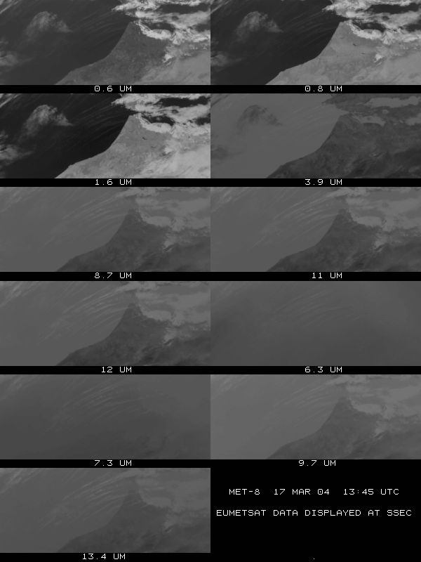 |
Click on the small image to see the eleven spectral bands that show numerous features including snow and low versus high clouds. |
 |
The first full Meteosat-8 image was received on March 17, 2004.A sample time period of a full disk image is also available. |
SSEC’s Volcano Watch presents satellite imagery of a dozen of the world’s most active volcanoes. Listed roughly from north to south, the volcanoes attract a great deal of attention from viewers around the world, especially people who live close to an active volcano. Hans Nadler, who lives near Popocatépetl volcano in central Mexico, noted that he could match the GOES images that are shown every half hour with what he could see from his yard. He also noted that Ixtaccihuatl, another volcano, can be seen as a vertical white line directly north of the Popocatépetl. Both together look like an inverted semicolon. SSEC doesn’t add volcanoes to the collection we now have posted on the Web. Both the Smithsonian Global Volcanism Program and Michigan Technological University’s Volcanoes Page provide updated information about volcanoes.
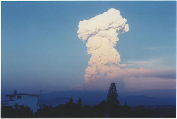 |
Popocatépetl volcano, the last time it erupted, in 2001. Hans Nadler |
The SSEC Web site and Volcano Watch have been included in GEsource, the “geography and environment gateway,” maintained by the University of Manchester.
SSEC’s Data Center provided satellite data for storms showed in Nova’s “Hunt for the Supertwister” shown April 6 on public television.
Japan’s Nippon Television is using an SSEC infrared composite image, with a strong solar component, in an educational program for high school students. The producers wish to show “how influential the sun … is.”
It must be cabin fever—Two students of communications at UW–Madison used the MODIS antenna tower in their creative work this winter. SSEC serves as a direct broadcast facility for data from the MODerate-resolution Imaging Spectroradiometer, an instrument on two NASA research satellites, Terra and Aqua. Data is received through a small tracking antenna housed in a radome covering, looking somewhat like a giant golf ball, or, to the eyes of student writer Nate Widboom, a “sex-pod/Doppler radar ball thing atop the meteorology building.” Widboom wrote in ArtsEtc. in the student newspaper The Badger Herald on February 25. Another student, Luke Spychalla, included many, many animated representations of the antenna tower in a wildly imaginative science fiction video, titled The Building Virus. The antenna is the villain of the piece, attacking unsuspecting bystanders somewhat as in Invasions of the Bodysnatchers.
Engineering Feats
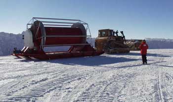
UW–Madison’s Physical Sciences Laboratory Observer newsletter (Spring 2004) featured work of SSEC’s Ice Coring and Drilling Services. The Enhanced Hot Water Drill, fabricated and assembled at PSL, was “successfully delivered to and assembled at the South Pole” this past season. SSEC engineer Jim Green and employees from A3RI, Triad and PSL assembled the giant hose reel for the drill at the South Pole. PSL is working with ICDS on drills and an ice test well. SSEC employees Bill Mason and Grant Emmel are developing mechanical and electrical elements of a deep ice sheet coring (DISC) drill, with assistance from PSL. Under funding from the NSF, SSEC’s ICDS will be able to drill to 1000 meters for ice cores in Antarctic ice.
Field Experiments and Meetings
June IMAPP Workshop—Allen Huang, a CIMSS senior scientist, is co-organizer of an IMAPP user training workshop held in conjunction with the 14th annual international TeraScan Conference. The conference and workshop will be held in June at Nanjing Institute of Meteorology in China. This and other meetings that SSEC and its scientists are helping to organize or sponsoring are now listed in one place on SSEC’s Web site. Contact webmaster Bill Bellon for more information about the page.
July Digital Library Meeting—The Earth Observer, January/February 2003, notes that the annual meeting of the Digital Library for Earth system Education (DLESE) will be held July 11-13 in Madison. The meeting’s broad theme is “DLESE: a Teaching and Learning Tool.” Maria Vasys, CIMSS administrative assistant, is making arrangements.
Planets
Mars Exploration—Right after NASA announced that Opportunity Rover had discovered strong evidence of past water on Mars on March 2, WKOW-TV, Madison’s Channel 27, interviewed planetary scientist Sanjay Limaye for his reactions. Newscasts at 5 and 10 p.m. showed Limaye and others viewing the NASA news conference. Limaye expounded upon the discovery.
Wired News published an image of Neptune produced from Hubble Space Telescope data by SSEC’s Larry Sromovsky and colleagues. Neptune is one of several images illustrating an article on the cancellation of the telescope. A link provides more information about the research, based on 1996 and 1998 images.Newer research on Neptune’s seasonal variations including images from 2002 has been available since April 2002.
Tracking Fires
The magazine Mobile Enterprise (December 2003) featured the work of the CIMSS group that monitors fires using GOES satellite information to detect and track fire and smoke. The magazine editor unfortunately chose a MODIS image (from a NASA satellite) to illustrate the small piece. The MODIS image was taken from the GOES Gallery where it was placed next to a GOES image that was provided by the biomass burning group.
Weather Events
Tornado Awareness—Just in time for tornado season, The Daily Cardinal student newspaper interviewed meteorology researchers, professors and students. Nick Zachar’s article in the April 14 paper noted that SSEC’s Atmospheric Emitted Radiance Interferometer is used to “dissect the inner workings of thunderstorms and tornadoes.” It is true that the AERI is used in severe storms studies, but researchers Derrick Herndon (SSEC’s CIMSS), Gary Wade (NOAA’s ASPT, stationed at SSEC) and Ed Hopkins (Wisconsin’s Assistant State Climatologist) all stressed the importance of watching and being aware of your surroundings when severe weather occurs. Tornadoes are unpredictable. Professor Greg Tripoli (Dept. of Atmospheric and Oceanic Sciences) explained that a “tornado develops from a rotation existing at low levels” [close to the ground, so impossible to see in satellite images]. The National Weather Service office at Sullivan, WI has more tornado awareness information on its Web site.
Weather Experts
 On the Rooftop—WISC-TV (Channel 3 in Madison, Wisconsin) began a series of “Live at 5” remote broadcasts on the top of the Atmospheric, Oceanic and Space Sciences building at UW–Madison. Channel 3 meteorologist Gary Cannalte appeared with program anchor Mark Koehn on roof of the 16-story building for the 5 o’clock news. Cannalte also weathercast from the building during the 6 p.m. news. Koehn and Cannalte interviewed incoming chair of the Department of Atmospheric and Oceanic Sciences who characterized the building as an excellent learning environment for students and, with its several groups pursuing different but compatible areas of science, a great opportunity for scientists to do research. Martin took care to name all the groups, showing the multidisciplinary nature of the building’s science. Cannalte explained the weather-related hardware on top of and in the building, all devoted to weather satellite data, and separately interviewed Steve Ackerman, director of SSEC’s Cooperative Institute for Meteorological Satellite Studies, who showed how the data is used in research. SSEC’s Data Center and MODIS research were also included, to show how the data is received and used. In the words of at least one viewer, “It was an awesome show.” Even somes unrelated news items were connected somehow to the theme of height such as Cheryl Crowe’s recent performance on an airplane.
Weather Guys Jonathan Martin and Steve Ackerman appear almost every last Monday of the month on Larry Meiller’s WHA Radio. The last Monday of May falls on May 31, Memorial Day, traditionally the annual bird show, so the Weather Guys will not appear. Listen to them next on Monday, June 28, in Madison and the surrounding area on 970 AM or 90.7 FM or on the Web from anywhere. If you’ve missed a show, the last year’s shows are archived in the Web site, by date.
Weather Research
Supercomputer Funding Made Available—SSEC has received one of 213 awards through the Defense University Research Instrumentation Program (DURIP) for $445,000 to purchase supercomputer components. The awards, made to 92 academic institutions, range from $50,000 to $900,000, averaging $205,000. SSEC’s award will support data processing and development of high-spectral-resolution imagery, such as would be received by the proposed GIFTS instrument, vital to the continued development of better atmospheric research instruments and better climate and weather forecasts, particularly for severe weather. According to the U.S. Department of Defense, “DURIP meets a critical need by enabling university researchers to purchase scientific equipment costing $50,000 or more to conduct DoD-relevant research.” Researchers generally have difficulty purchasing instruments costing that much under current research contracts and grants.
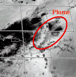
The GOES Sounder Monitors Upper Level SO2 Plumes—Tim Schmit and Tony Schreiner of the SSEC investigated an upper level sulfur dioxide (SO2) plume that resulted from the eruption of the Soufriere Hills volcano on the island of Montserrat in the eastern Caribbean. The scientists generated a series of images on two bands from the Geostationary Operational Environmental Satellite (GOES)-12 Sounder. They subtracted one band from the other to arrive at an image of the SO2 plume. The resulting plume corresponds to those derived from Atmospheric InfraRed Sounder (AIRS) and the Total Ozone Mapping System (TOMS). Tracking SO2 plumes associated with volcanic eruptions is important because they can clog the engine of any airplane that flies through them. Another reason scientists study SO2 plumes is to gain a better understanding of the transport of SO2 as a trace gas in relation to air quality. Click on the small image for a montage.
WF_ABBA Imagery Used to Monitor Brazilian Hurricane—When a hurricane developed off the coast of Brazil in late March for the first time in recorded history, the Brazilian weather service called on the SSEC Biomass Burning group to help track the storm. Why would Brazil choose to use a fire-monitoring group to track a hurricane? South American GOES satellite imagery is not available on the Web in loops and the hurricane happened to be in the center of a predefined region monitored by the Biomass Burning group. On March 28 an advisory from the Brazilian Meteorological agency cited a Wildfire Automated Biomass Burning Algorithm (WF_ABBA) Web page as a site for monitoring the progress of the hurricane as it made landfall. The loop is now online, along with other imagery, at the CIMSS Tropical Cyclone group’s case study Web page.
CIMSS Follows South Atlantic Tropical Cyclone—C. Velden, T. Olander and D. Herndon of the Cooperative Institute for Meteorological Satellite Studies (CIMSS) monitored the exceptionally rare South Atlantic tropical cyclone this March. The scientists used algorithms to estimate structure and intensity from multispectral satellite data and concluded that the cyclone was clearly a tropical event. They used their infrared-based Advanced Objective Dvorak Technique (AODT), which provides an objective forecast of tropical cyclones, and their Advanced Microwave Sounding Unit (AMSU) method during the event and obtained central pressure estimates as low as 974 hPa. Upon landfall, this system caused considerable damage and resulted in some deaths. It has yet to be confirmed, but this storm could be recognized as the first southern Atlantic hurricane in recorded history. The issue—whether or not the storm is really a hurricane—will be debated in Miami this month at the Hurricane Conference sponsored by the American Meteorological Society.
Hyperspectral Environmental Suite Animations—The Hyperspectral Environmental Suite (HES) will appear on a geostationary satellite around the year 2013, and animations are already being created to show its advantages over the current Geostationary Operational Environmental Satellite (GOES) Sounder. Mesoscale Model 5 (MM5) data from THe Observing system Research and Prediction EXperiment (THORPEX) were used to create the HES animations. The simulated HES cloudy-sky radiances and the simulated GOES sounder clear sky radiances were used in the comparison. The animation shows the 900 hPa temperature and moisture images from the MM5 (“truth”), retrievals from simulated HES cloudy radiances and the current GOES sounder clear radiances. The animations can be viewed at: (moisture) and (temperature).
GIFTS Algorithms Done Here—SpaceNews credited the Navy with work on GIFTS that SSEC is performing. A “Military Space” article noted that “the Navy is working on mathematical models that are intended to be used to analyze the cloud and wind data gathered by the instrument.” Instead, the SSEC is contracted to write algorithms (mathematical models) and develop useful products for GIFTS. As noted in the article, GIFTS is in jeopardy, apart from the Navy’s involvement.
Sea Surface Emissivity Model Made Available—Paul van Delst, of CIMSS, stationed in NOAA’s Office of Research and Applications near Washington, D.C., has completed an Infrared Sea Surface Emissivity (IRSSE) model based on Wu-Smith sea surface emissivity data. The model is being used in the National Center for Environmental Prediction Global Data Assimilation System. Fuzhong Weng, Deputy Director of NOAA’s Joint Center for Satellite Data Assimilation in the NESDIS, said that the emissivity model will be included in the JCSDA community-based radiative transfer model as well. Xiangqian Wu, NOAA, developed the initial technique on which the model is based and said that the model could not have been developed “without the hyperspectral observations of the sea surface using a ship-borne HIS, later know as M-AERI, during a 1995 field experiment. The HIS, M-AERI, and the 1995 cruise all represent major SSEC/CIMSS contributions.” Wu refuses to take complete credit for the research and adds, “Critical contributions from SSEC/CIMSS during my research include
· Constant encouragement and support from, and discussion with, Bill Smith [then CIMSS director]
· Introduction to the problem by Chris Velden
· Previous work (probably by Nick Nalli and Wayne Feltz)
· Discussions with Barbara Burns, Bob Knutson, and Barbara Whitney [then all SSEC scientists]
· Literature searches by Jean Phillips [librarian, The Schwerdtfeger Library]”
Wu states that the IRSSE model is different from Masuda’s SSE model (developed in 1988) in that the CIMSS model “accounts for the reflected sea surface emission.” He stated that the CIMSS group could speculate along that line because they were “first to have these unique hyperspectral observations from a well designed experiment.”
Papers
“A multiscale remote sensing model for disaggregating regional fluxes to micrometeorological scales,” by Martha C. Anderson, John M. Norman, John R. Mecikalski, and others appeared in Journal of Hydrometeorology, v.5, no.2, 2004, pp. 343-363.
“Estimating land surface energy budgets from space: Review and current efforts at the University of Wisconsin-Madison and USDA-ARS,” by George R. Diak, John R. Mecikalski, Martha C. Anderson, John M. Norman, and others, appeared in Bulletin of the American Meteorological Society, v.85, no.1, 2004, pp. 65-78.
“Mesovortices in Hurricane Isabel,” by James P. Kossin and Wayne H. Schubert, appeared in Bulletin of the American Meteorological Society, v.85, no.2, 2004, pp.151-153.
“Assimilating GOES brightness temperatures, Part I: Upper-tropospheric moisture,” by William H. Raymond, Gary S. Wade and Tom H. Zapotocny, was published in the Journal of Applied Meteorology,v.43, no.1, 2004, pp.17-27.
“Intercalibration of the infrared window and water vapor channels on operational geostationary environmental satellites using a single polar-orbiting satellite,” by Mathew M. Gunshor, Timothy J. Schmit, and W. Paul Menzel, in Journal of Atmospheric and Oceanic Technology, v.21, no.1, 2004, pp. 61-68.
“A study of the Antarctic surface energy budget using a polar regional atmospheric model forced with satellite-derived cloud properties,” by Michael J. Pavolonis, Jeffrey R.Key and John J. Cassano, was published in “Notes and Correspondence” in Monthly Weather Review, v.132, no.2, 2004, pp. 654-661.
“Analysis of 10.7 micron brightness temperatures of a simulated thunderstorm with two-moment microphysics,” by Lewis D. Grasso and Thomas J. Greenwald, appeared in Monthly Weather Review,v.132, no.3, 2004, pp. 815-825.
Education, Outreach, Service
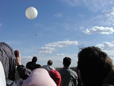
Science Excitement—SSEC participated in UW–Madison’s second Science Expeditions on April 3 and was included in all promotion, from the snazzy “science green” brochure to news releases advertising the event. Unlike the 2003 event, exploration stations were set up in the Atmospheric, Oceanic and Space Science Building where 300 visitors participated in several events: SSEC held a roof tour, in spite of near gale-force winds; SSEC’s Office of Space Science Education demonstrated a Mars Rover model and showed movies; the Antarctic Meteorological Research Center opened its doors, giving a glimpse of research in Antarctica and showing the data it provides; the Environmental Remote Sensing Center provided high-resolution photographic maps of Dane County neighborhoods; and the Department of Atmospheric and Oceanic Sciences provided information and a tour of the State Climatology office. About 100 people crammed the building roof for the highlight event, launch of a weather balloon, known technically as a radiosonde.
Jay Otto
In the Engineering Building, Weather Guys Ackerman and Martin and AMANDA researchers were part of 25 exploration stations, welcoming more than 1000 guests from around Dane County.
Flat Stanley in Antarctica—Ever since Jeff Brown first created the paper doll, Flat Stanley, school children have found new places to send him. This year, students in Orange County, California sent Flat Stanley to Antarctica, where George Weidner and Matthew Lazzara posed him outside the AWS storage shed. The Orange County Register noted the event on April 7, but got it a little wrong—the Register said that “the scholars posed the Stanley in the outhouse.” It is true that most smaller research buildings in Antarctica aren’t very picturesque, but “outhouse”?
NOAA at Science Fair Night—The SSEC continues to provide outreach programs to the community. Recently, Bob Aune and Kathy Strabala ran a booth at the annual Science Fair Night at Elm Lawn Elementary School in Middleton, WI. The theme of the booth was “Using Satellites to Understand Our Earth.” Examples of satellite imagery from MODIS and GOES were used to explain how forecasters use satellite data in computers to forecast the weather. Kids were also able to test out their weather forecasting abilities using Vis5D, a three-dimensional visualization tool.
SSEC planetary scientist Sanjay Limaye is featured in Loksatta (People Power), a newspaper in Mombai, India. Limaye visited the subcontinent to give a talk on space exploration and educational outreach in February. Limaye is a representative to the India-U.S. Collaborative Conference, to be held in June in Bangalore.
Honors
Robert S. Wacker, a researcher and Ph.D. student in CIMSS’ Tropical Cyclones group, is also in the U.S. Air Force. In March he was promoted from Captain to Major, as noted in XOWgram 04-10 from Brigadier General Thomas E. Stickford, Director of Weather for the USAF DCS/Air and Space Operations.