Monthly News Summary – February 2004
Showing the Cold
This issue of SSEC In the News covers news and research results primarily from January 2004. Use images freely with credit to the Space Science and Engineering Center, University of Wisconsin–Madison, but please notify SSEC’s Public Information Officer. Individual photographers retain copyright; contact them or me to use a photo.
In Wisconsin, you’d think we’d be used to cold winters. However, the last two have been unseasonably warm, so when the polar winds started to blow in December, and kept steadily blowing through January, we found we were not completely prepared. For all the snow and wind, there’s a bright side—impressive imagery of various cold weather outbreaks, throughout the world, not only in Wisconsin.
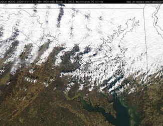
So Cold, So Dry…—Surface features across the northeastern United States and southeastern Canada (the northern Great Lakes, coastal New England, and the Saint Lawrence River) could be seen in “water vapor channel” (6.5 micrometer wavelength) data from the Geostationary Operational Environmental Satellite (GOES-12) imager on January 13 and 14. The air mass across that region was extremely cold and dry, and water vapor weighting functions calculated from weather balloon data showed that the radiation sensed by this channel originated from unusually low levels of the troposphere; i.e., close to the surface of the earth. The atmosphere was so cold and dry that the water vapor channel was able to “see” much deeper through the atmosphere than normal. In fact, it could see all the way to the ground, where it was able to detect the temperature contrasts (not the water vapor content) of the Great Lakes and New England. Normally the signal from water vapor in the middle troposphere dominates this channel, but since there was nothing to attenuate (block) the surface signal, the satellite could receive the signal of surface temperature contrasts.
 |
This “water vapor channel” image taken by the GOES-12 imager at a wavelength of 6.5 micrometers shows surface features on January 14, 2004. |
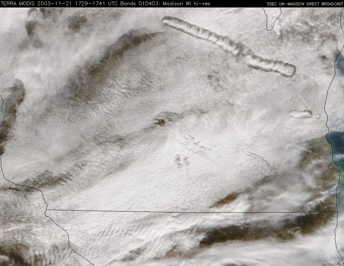
Super Cool(ed)— The big, wormy-looking cloud in this image from the MODerate-resolution Imaging Spectroradiometer (MODIS) is an “aircraft-induced cloud dissipation trail.” Scott Bachmeier has posted a study of these clouds and explains that “particles within the ‘trail’ of jet exhaust are acting as cloud condensation nuclei, initiating a chain reaction of cloud glaciation (becoming ice). The planes fly through a cloud that consists of super-cooled water droplets (droplets that are liquid at below-freezing temperatures), the exhaust particles touch these super-cooled droplets, and they freeze instantly, turning into ice particles that begin to fall. They grow as they fall by colliding with other super-cooled cloud droplets, and other ice particles. As this process continues, the cloud begins to dissipate somewhat (the larger ice particles fall out as virga), but a narrow path of ice crystals remains in the portion of the cloud that the plane flew through—these particles are too small to fall to the ground. So the cloud dissipates somewhat, but not completely … and the character of the cloud (super-cooled water droplets) changes to ice particles.”
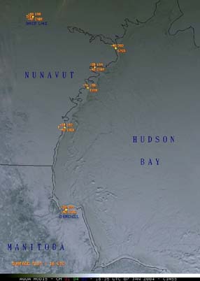
Spotlighting Cold Places—Through SSEC’s MODIS direct broadcast facility, Scott Bachmeier found images of Canada’s frozen Hudson Bay, at -50° F. For SSEC’s spotlight, he also showed extreme cold in Siberia, down to -70° F.
Antarctica
Field Season, by George Weidner—In January, the Antarctic Automatic Weather Station Program began its annual field season. While based in McMurdo Station, Antarctica, this year’s field team of researchers George Weidner (Department of Atmospheric and Oceanic Sciences) and Jonathan Thom (SSEC) travel around the continent doing preventive maintenance and repairing weather stations. The team maintains their own array of stations and will deploy three stations with Dr. John Cassano of the University of Colorado, also at McMurdo Station, and with Ron Ross of Stanford University. Ross is installing a Webcam for educational outreach, collaborating with Douglas MacAyeal, University of Chicago glaciologist, on one of the large icebergs that calved from the Ross Ice Shelf since 2000 and has remained near McMurdo Station.
First visited was the Automatic Weather Station (AWS) site at Minna Bluff, named for the geographic feature where the station is located. Here, winds can exceed 60 mph for long periods of time. During this year’s visit, Dr. Cassano and George Weidner discovered that the power cable had been worn through as the tower motion, caused by the extreme winds during the past year, rubbed the cable against the battery boxes at the base of the tower.
During the three-week maintenance season, Weidner and Thom serviced six stations, scattered across about one fourth of the giant continent. UW–Madison’s Antarctic Automatic Weather Station Program is funded by a grant from the National Science Foundation.
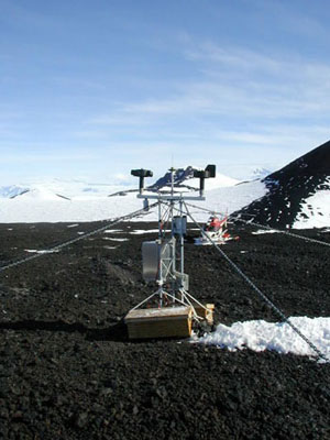 |
The Automatic Weather Station Minna Bluff named for the formation it is near. |
A picture of an Automatic Weather Station was used in a children’s book on weather and climate change, published by Usborne Publishing Ltd. in England.
Data and Imagery
Heat—Jeff Miller, photojournalist in the university’s Communications Office, took an unusual photo of buildings on campus for the campus newspaper, Wisconsin Week, January 28. Using an infrared camera, Miller took pictures of the south campus, which showed heat in the physical plant’s smoke stack and in the midsection of the Atmospheric and Oceanic Sciences building. Miller was surprised to see that parts of the building’s 7th floor were nearly as hot as the smoke stack. A call to the building manager, JoAnn Banks, determined that on 7th floor is located the building’s furnace.
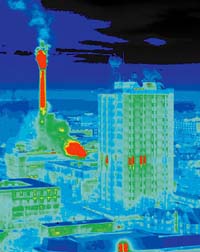 |
An infrared photograph of the Atmospheric, Oceanic and Space Sciences Building (foreground) with hot spotson 7th floor. Behind that building the Physical Plant’s smokestack and a steam plume can be seen prominently. Jeff Miller, University Communications photojournalist, took this picture. |
An Infinite Variety—On January 13, SSEC’s direct broadcast facility served up a variety of fascinating earth images from the MODIS instrument on NASA’s Aqua satellite. Many different atmospheric phenomena were observed on a single day. Through an X-band tracking antenna on its roof, SSEC receives data from as far north as Hudson Bay and as far south as the Yucatan peninsula in Mexico.
 |
An example of wave clouds, centered on Maryland, taken by the Aqua satellite’s MODIS instrument.Click on the image for more. |
Terra Returns—From November through mid-January, NASA’s Terra satellite had not sent data to earth. After working patiently through the issues plaguing the satellite, NASA was able to put the satellite back on line. SSEC’s Data Center received the first “new” MODIS image on January 15.
NASA Data to NOAA via SSEC—Through a collaborative project with NOAA, SPoRT (Short-term Prediction Research and Transition), NASA is providing data from its research satellites Terra and Aqua to help forecasters in the National Weather Service. According to Gary Jedlovec, a meteorologist at NASA’s Marshall Space Flight Center, “What we’re trying to do is to give the National Weather Service a head start with incorporating this higher-quality data into their forecasts.” Jedlovec is a leader of this NASA/NOAA collaboration. SSEC provides high-quality data from the MODIS instrument in near-real time from its direct broadcast facility.
Image Use—Jacques van Delft, a member of the solar section of ASSA Bloemfontein (Astronomical Society of South Africa), used an infrared global composite weather satellite image from SSEC’s Web site to illustrate an article on climate change in Landbou Weekblad a weekly farm magazine. Van Delft color-enhanced the image to more nearly represent the seas’ true colors. The article is written in the Afrikaans language. It shows that solar activities are indeed affecting the climate and shows how unstable conditions in the upper Antarctic low-pressure region lead to developing low-pressure systems that contribute to climatic changes.
Engineering Feats
Tracks—The giant hose reel for an Enhanced Hot Water Drill has been assembled at the South Pole, in readiness for installing the neutrino telescope IceCube in Antarctic ice. IceCube Logistics Manager Terry Hannaford (Triad Project Management) explained that all the IceCube equipment, which takes up half a city block when assembled, was moved from Wisconsin in December on two flatbed trailer trucks to California.
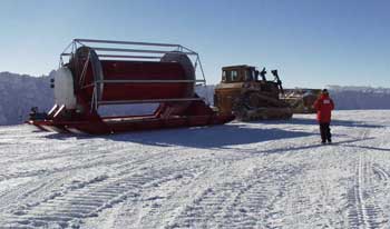
The equipment went via ship to Christchurch, New Zealand where it was flown on a C-141 cargo plane to the U.S. research base in McMurdo. From there, all the equipment was flown on an LC-130, a ski-equipped cargo plane, to the South Pole. IceCube is a multinational, multiorganizational effort, headquartered in UW–Madison’s Antarctic Astronomy and Astrophysics Research Institute. SSEC’s Ice Coring and Drilling Services provides engineering support, including drilling holes more than a kilometer deep for neutrino detectors. The National Science Foundation supports the IceCube project, as it does nearly all U.S. Antarctic research. UW–Madison’s campus newspaper, Wisconsin Week, reported the news on January 28, in “Advances.” A longer version of this story is on the IceCube Web site.
Field Experiments and Meetings
GOES-R Users Conference—A conference will be held May 10–13, 2004, in Boulder, Colorado for potential users of the next GOES to help them prepare to acquire, digest, and use the new data and to assist with advanced planning of requirements, products, communications, and distribution of data. The conference will consist of speaker presentations, poster sessions, and facilitated breakout sessions. The conference is designed to provide two-way communication between NOAA’s National Environmental Satellite, Data, and Information Service, who manage operational weather satellites, and the GOES user community; inform GOES data users of plans for the next generation of satellites; provide information on potential applications; determine user needs for new products; and assess potential user and societal benefits of GOES capabilities. According to NOAA, this new GOES, planned for launch in 2012, will “scan the Earth nearly five times faster than the current GOES. The satellites will provide the user community (television meteorologists, private weather companies, the aviation and agriculture communities, and national and international government agencies) with about one hundred times the amount of data currently provided.” Read more about the conference on its Web site. Conference coordinators Tim Schmit (NOAA, stationed at SSEC) andDick Reynolds are seeking poster papers.
Two images produced in SSEC’s Cooperative Institute for Meteorological Satellite Studies (CIMSS), who do research with GOES data and provide science input into instrument design, are prominent on the front of the conference brochure. Featured are a montage made from a series of GOES images of Hurricane Isabel produced by Gary Wade (NOAA, stationed at SSEC), and a MODIS image of Hurricane Isabel produced by Chris Schmidt (CIMSS’ group that monitors biomass burning with GOES data). On the brochure’s back cover is a water vapor image, provided by the SSEC Data Center.
India-U.S. Collaborative Conference—Rose Pertzborn, director of SSEC’s Office of Space Science Education, will co-chair the education committee of a joint India-U.S. conference on future space science programs and opportunities for bilateral collaboration. Her Indian counterpart is a yet-to-be-named physicist. This preliminary conference will produce findings and recommendations toward a memorandum of understanding. Participants will examine the current status of math and science education, kindergarten through college, in both countries. The conference will be held in June in Bangalore, India.
AMS 84th Annual Meeting—SSEC annually rents booth space in the exhibit area at the AMS Annual Meeting. As SSEC has in the past, so this year the booth was used to demonstrate SSEC’s visualization tools and science, and to provide information on its close connection with UW–Madison’s Department of Atmospheric and Oceanic Sciences. In the booth, researchers used four computers for demos and scientific presentations and gave impromptu talks about SSEC’s research. For the four days of the conference, the booth was not empty of visitors while the exhibition hall was open. Valuable connections were made—potential collaborators, educators, students, interested scientists, and technical people—all visited the booth to learn about SSEC’s activities. Moreover, SSEC people were able to network at the booth, in other booths, and throughout the meeting. SSEC researchers presented posters and papers, and a CIMSS researcher noted that, while the conference enabled scientific exchange, it provided an opportunity to be briefed on government initiatives such as new instruments and programs like NPOESS.
As has occurred in the past, SSEC and its CIMSS work was noted in meetings and in other exhibition booths. For Example, SeaSpace, a company making hardware and software to receive and process remote sensing data, prominently featured the Advanced Objective Dvorak Technique, an algorithm developed by the CIMSS Tropical Cyclones group to track storm track and intensity. The SeaSpace software program, TeraScan, incorporates the CIMSS algorithm.
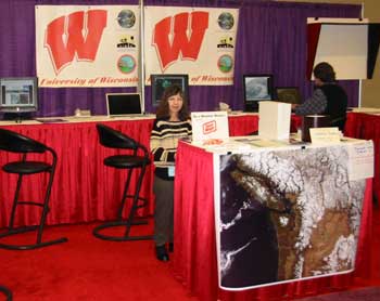 |
Terri Gregory, SSEC’s Public Information Coordinator, and Tom Achtor, SSEC’s Executive Director for Science, wait for customers on the first day the exhibit hall is open for business.Many more images of the AMS Annual Meeting and activities of participants are in a Web album. |
With Seattle’s NWS office, SSEC was responsible for daily weather briefings given twice daily at the conference. Robert Aune gave the last briefing, showing the latest applications of GOES sounder data to numerical weather prediction.
Besides the researchers, whose papers are listed in the meeting’s program, and the exhibiters, many other SSEC people made our conference presence possible—Maria Vasys, Marlene McCaffery, and Mike Dean primarily.
Arctic Climate Workshop—Jeffrey Key, team leader of NOAA’s research group at SSEC, the Advanced Satellite Products Branch, gave an invited talk at an international workshop on Arctic climate change held at the Lamont Doherty Earth Observatory in Palisades, NY, in January. Key spoke on surface, cloud, and radiative properties of the Arctic as observed by satellite. The workshop, titled “Central Arctic: Battleground of Natural and Man-Made Climate Forcing,” covered topics from current Arctic climate characteristics to the relationship between recent Arctic warming and that experienced in the 1930s and 1940s.
Planets
Mars Exploration—When President Bush announced his proposal for a moon base and manned Mars mission, WKOW Madison TV channel 27 spoke with Rose Pertzborn, director of SSEC’s Office of Space Science Education. Pertzborn, who worked at NASA Headquarters in 2002, noted that the costs were “vastly underestimated” and that interest in space exploration would surely increase. Indeed, her office has received many calls from local schools to talk about Mars just since the segment ran on nightly news on January 14. Both she and planetary scientist Sanjay Limaye have given numerous talks to groups, including schools, since Opportunity and Spirit have touched down on Mars.
Neptune—The weekly magazine, Science News, mentions Neptune seasonal changes in its annual highlights column (vol. 163, p. 325). SSEC planetary scientist Lawrence Sromovsky leads that research.
Polar Science
The Canadian Meteorological Centre’s (CMC) numerical weather prediction (NWP) system is demonstrating a positive impact on forecasts when they assimilate polar wind measurements from MODIS, particularly over the Arctic and Southern Hemisphere (poleward of 20 degrees south latitude). The results are part of an experiment that began November 5, 2003 and involves CMC, NASA’s Global Modeling and Assimilation Office (associated with the Joint Center for Satellite Data Assimilation), the European Centre for Medium-Range Weather Forecasts (ECMWF), and the UK Met Office. All centers are experimenting with wind measurements from CIMSS and from NOAA’s Office of Research and Applications Forecast Products Development Team.
Software
VISITview Highlighted—A World Meteorological Organization (WMO) Workshop held at the Regional Meteorological Training Center (RMTC) in Barbados in December 2003 made extensive use of VISITview, according to Anthony Mostek of NOAA’s National Weather Service Office of Climate, Water, and Weather Services. VISITview is a real-time training software package that connects instructors and students via the Web. The instructor and students are linked together to share graphics, animations, annotations and questions to provide a rich learning experience.
Mostek is acting Branch Chief of the Training Division’s Cooperative Program for Operational Meteorology Education and Training. In his report on the WMO sponsored workshop, Mostek said, “The organizers of the WMO workshop wanted to build on the success of the first international satellite weather briefing in May 2002 in Melbourne, Australia, during the Asian Pacific Satellite Applications Training Seminar (APSATS).” In May 2002, VISITview made possible the first long-range, multisite weather briefing of satellite imagery. Another long-range weather briefing was given at the Barbados workshop with scientists participating remotely from the Cooperative Institute for Research in the Atmosphere in Ft. Collins, Colorado; the Cooperative Institute for Meteorological Satellite Studies (CIMSS) in Madison, Wisconsin; and from Costa Rica’s RMTC. Attending in Barbados were instructors from Australia’s Bureau of Meteorology, WMO and CIRA, and the students. At the workshop, Mostek presented training on how to use VISITview, and then allowed participants to “build” their own VISITview training sessions. Selvin Burton of the Caribbean Institute for Meteorology and Hydrology said, “VISITview was the highlight of the WMO RMTC workshop on satellite meteorology.”
The Virtual Institute for Satellite Integration Training (VISIT) includes staff from cooperative institutes CIMSS and CIRA, and from NOAA’s National Environmental Satellite, Data, and Information Service and National Weather Service training division. The VISIT project developed VISITview as a tool to provide distance training and live collaboration. Over the past three years, several other WMO training events have used VISITview to facilitate participation for people who could not attend the event in person, as well as for those who could. Those events were held in Nanjing, China in December 2000; in Melbourne, Australia in May 2002; in Niamey, Niger in July 2003; as well as the most recent workshop held in Barbados.
For more information
Tropical Cyclones
Cover Picture—“The Impact of the Saharan Air Layer on Atlantic Tropical Cyclone Activity,” by Jason Dunion and Chris Velden, appears in the March issue of the Bulletin of the American Meteorological Society. The journal’s cover features a MODIS image illustrating the phenomenon. The paper demonstrates the ongoing collaboration of NOAA’s Atlantic Oceanographic and Meteorological Laboratory’s Hurricane Research Division, Dunion’s home agency, and SSEC’s Cooperative Institute for Meteorological Satellite Studies, where Velden leads the Tropical Cyclones group.
Hurricane Isabel—In September, CIMSS Tropical Cyclone team members monitored the progress of Hurricane Isabel. One of them, Jim Kossin, was able to see briefly in the hurricane’s eye structures called mesovortices that he had previously theorized. According to Kossin and fellow researcher Wayne Schubert, “The [starfish] pattern was due to the presence of 6 distinct mesovortices—one in the center and five others arranged fairly symmetrically around the center.” Their note describing the structure appears in the Bulletin of the American Meteorological Society for February as “Mesovortices in Hurricane Isabel.”
 Kossin and Wayne Schubert. Isabel was useful in several ways to scientists studying these storms, as noted in the Milwaukee Journal Sentinel article by Meg Jones.
AMSU Technique—NOAA’s Tropical Prediction Center (TPC) has evaluated the CIMSS Tropical Cyclones group’s technique of estimating storm intensity using radiance measurements from the Advanced Microwave Sounding Unit (AMSU), a NASA satellite instrument . This technique was developed under a recently concluded Joint Hurricane Testbed (JHT) project in the U.S. Weather Research Program. Testing and evaluation activities conducted during the Atlantic tropical cyclone season in 2003 produced very encouraging results. As a result, Max Mayfield, Director of the Tropical Prediction Center, has decided to implement the technique operationally. The JHT staff will continue working with the TPC staff and the CIMSS researchers on the implementation process during the coming months.
The Observer, The Magazine for Air Force Weather (Nov./Dec. 2003) features the collaboration of CIMSS with students and faculty in the Department of Physics at the U.S. Air Force Academy. Major Kurt Brueske, now associate professor at the Academy, helped develop the AMSU algorithm in CIMSS while pursuing an atmospheric science Ph.D. at UW–Madison. Currently Captain Bob Wacker is refining the technique while pursuing a Ph.D. Chris Velden, team leader of the CIMSS Tropical Cyclones group, agrees that the Air Force/CIMSS collabortion yields benefits, not only to both programs, but “to the research and understanding of tropical cyclone behavior.”
Weather Experts
Weather Guys—Steve Ackerman (CIMSS director and professor, Department of Atmospheric and Oceanic Sciences, AOS) and Jonathan Martin (professor, AOS) appeared on Larry Meiller’s WHA Radio call-in show on January 26. During the show, Wisconsin and most of the United States east of it, was receiving heavy snow, bringing in many questions about snowfalls and other cold weather issues. Weather Guys Martin and Ackerman generally appear the last Monday of every month. Listen in at 11:45 till 12:30 at 970 AM, 90.7 FM or on the Web. Click on “Listen Live to the Ideas Network” in the middle of the page.
Visiting Scientist—Bob Rabin is a researcher who splits his time between SSEC and NOAA’s National Severe Storms Laboratory in Norman, Oklahoma. In January, The Oklahoman newspaper interviewed Rabin about his collaboration. According to staff writer Leonard Jackson, “his research uses the strong points of both satellites and radar to anticipate better the formation and growth of storms.” Rabin also uses satellite data to investigate the effect of vegetation on cloud formation. This has implications for climate change, and Oklahoma’s winter wheat fields provide the perfect research environment. Rabin takes expertise in satellite meteorology from SSEC’s CIMSS to Norman’s lab and is using in Wisconsin Doppler radar applications developed in Oklahoma. Rabin credited SSEC founding director Verner E. Suomi (1917–1995) with putting energy-measuring instruments on satellites as early as 1959. Suomi, known as the father of weather satellites, also invented the spin-scan camera, making it possible to take pictures of the earth from geostationary orbit.
Weather Research
New and Continuing NASA Projects—The recent round of NASA funding announcements enabled SSEC and its CIMSS to begin new weather satellite-related research and continue projects already started. In April, SSEC scientists submitted 17 proposals to NASA’s Earth Observing System (EOS) and 5 to the National Polar Orbiter Environmental Satellite System Program (NPP). Of those, nine EOS proposals and three NPP proposals were funded. Most projects funded involve analyzing data from the MODerate-resolution Imaging Spectroradiometer (MODIS) on both Aqua and Terra research satellites and the Atmospheric InfraRed Sounder (AIRS) on Aqua. SSEC researchers helped make those instruments and serve on science teams to develop useful products from them. New projects using MODIS data include the study of cloud properties and cloud mask development, polar wind studies, and the study of multilayered clouds and cloud phases. Land surface characterization will be made with the AIRS and MODIS, and AIRS products will be validated.
One project will use data collected by instruments at a site maintained by the Department of Energy. In Oklahoma, the Cloud And Radiation Testbed in the Atmospheric Radiation Measurement program gathers information with a number of instruments including some of SSEC’s Atmospheric Emitted Radiance Interferometers. Dave Tobin and others will validate AIRS and MODIS measurements taken over the site with AERI and other measurements, which have all been proven accurate over years of collection. SSEC’sdirect broadcast facility will also continue to be supported by NASA. An antenna on the roof of the building housing SSEC receives and distributes information from Terra and Aqua polar-orbiting satellites from far north in Canada to the Yucatan Peninsula and from the east coast of the U.S. to California. SSEC trusts that NASA will continue its commitment to Earth Science along with its current, ambitious plan of solar system exploration. However, the American Institute of Physics reports (FYI #15) that the Bush administration has sent a budget bill to Congress that decreases NASA’s earth science budget by 7.9% or $128 million, from $1,613 million to $1,485 million.
CLAVR Used for Sea Surface Temperatures—The Institute for Meteorology at the University of Edinburgh, Scotland, asked to use high-resolution cloud mask and sea surface temperature (SST) data from the CLouds from the Advanced Very High Resolution Radiometer (AVHRR) extended system (CLAVR-x). The Institute for Meteorology collaborates with NOAA’s Office of Research and Applications (ORA). Andy Heidinger (of NOAA’s ASPB at SSEC, part of ORA) modified the research system to include a cloud mask. The operational version will be modified to routinely provide sea surface temperature data with a cloud mask to show clear and cloudy areas. CLAVR-x data is used to develop a blended sea surface temperature product from multiple sensors.
CRAS Forecasts Fog—The application of the CIMSS Regional Assimilation System (CRAS) to forecasting fog is featured in Advances, the research column in UW–Madison’s campus newspaper,Wisconsin Week (February 11, 2004). Bob Aune (NOAA, at SSEC) has tested the CRAS, a numerical modeling program with water vapor and cloud observations from GOES-12 and is encouraged by the results. CRAS is the first and oldest forecast model to incorporate satellite information.
Papers
The CIMSS group that monitors biomass burning using geostationary weather satellites was asked to present a paper at the U.S. Department of Agriculture (USDA) Forest Service Remote Sensing Applications Conference to be held in Salt Lake City on April 5-9, 2004. “Geostationary Satellite Fire Monitoring Using the Wildfire Automated Biomass Burning Algorithm” by E. Prins of NOAA’s ASPB and C. Schmidt and J. Feltz of CIMSS will be included in a special session on collaborative efforts in fire remote sensing.
“Sea ice surface temperature product from the Moderate Resolution Imaging Spectroradiometer (MODIS)” was accepted for publication in the journal IEEE Transactions on Geoscience and Remote Sensing. The authors are D. Hall (NASA’s Goddard Space Flight Center (GSFC)), J. Key (NOAA’s ASPB), K. A. Casey (GSFC), G. A. Riggs (GSFC), and D. J. Cavalieri (GSFC). The paper introduces the MODIS sea ice temperature product, the retrieval methodology, and validation over the Arctic and Antarctic.
“A pronounced bias in tropical cyclone minimum sea level pressure estimation based on the Dvorak technique,” by James Kossin and Christopher Velden, was published in the Monthly Weather Review,v.132, no.1, 2004, pp. 165-173.
“Detection and analysis of clear sky, low-level atmospheric temperature inversions with MODIS,” by Y. Liu (CIMSS) and J. Key (NOAA, ASPB), was published in the Journal of Atmospheric and Oceanic Technology (December 2003, vol. 20, pp. 1727-1737). The paper presents a method for estimating low-level atmospheric temperature inversion strength, defined as the temperature difference across the inversion, and height using MODIS. Inversion strength can be estimated with an uncertainty of 2–3° C; the uncertainty in inversion height is 100–200 m.
“Estimating Land Surface Energy Budgets From Space: Review and Current Efforts at the University of Wisconsin–Madison and USDA–ARS,” by George R. Diak, John R. Mecikalski, Martha C. Anderson, John M. Norman, William P. Kustas, Ryan D. Torn, and Rebecca L. DeWolf, was published in the Bulletin of the American Meteorological Society, January, pages 65–78.
Tim Schmit and Robert Aune (both with NOAA’s ASPB at SSEC) have submitted abstracts to the National Highway Visibility Conference to be held May 17–19, 2004, in Madison, WI. The Federal Highway Administration and the Wisconsin Department of Transportation are sponsoring the conference. The papers are “Challenges in fog detection from current satellite data and numerical model output” and “Future geostationary observations for the improved detection and short-range prediction of fog.”
“Overview of NOAA’s GOES Hyperspectral Sounding Data, Communication and Compression Activities,” by R. Heymann (Office of Systems Development in NOAA’s NESDIS) and T. Schmit (ASPB at SSEC), was submitted to the Society of Photo-optical Instrumentation Engineers (SPIE) Atmospheric And Environmental Remote Sensing Data Processing And Utilization: An End-To-End System Perspective conference. Schmit is on the program committee with others from the ASPB, CIMSS and elsewhere. Conference cochairs are Allen Huang, SSEC’s CIMSS, and Hal J. Bloom, NOAA.
Abstracts by Jun Li, Fang Wang, W. Paul Menzel, Timothy Schmit, Rich Frey, and James Gurka have been submitted for the Third GOES-R Users Conference, to be held in May near Boulder, Colorado.
- Study of the Hyperspectral Environmental Suite (HES) on the GOES-R and beyond
- Using Advanced Baseline Imager (ABI) to help HES for atmospheric sounding
- Cloud retrieval and ABI cloud mask study using MODIS data
Education, Outreach, Service
The Executive Committee of the Division for Planetary Sciences of the American Astronomical Society has enthusiastically endorsed the appointment of SSEC planetary scientist Sanjay Limaye as the incoming Press Secretary for a three-year term, beginning with the 2005 meeting in Cambridge, England. Limaye’s appointment was announced in DPS Mailing #04-01 on January 20. Until September, Limaye will continue to serve as Deputy Press Secretary to Ellis Miner.
On January 1, Jeff Key (NOAA/NESDIS ASPB at SSEC) began serving a three-year term as an associate editor of the Journal of the Atmospheric Sciences specializing in radiation.
Chris Velden (CIMSS) has been elected to serve as chair of the American Meteorological Society’s (AMS) Satellite Meteorology and Oceanography Committee. The three-year term begins February 1.
Honors
Robert Holz has received the second Suomi-Simpson Fellowship. Holz is a graduate student pursuing an atmospheric science Ph.D. with Steve Ackerman, CIMSS director and professor in the Department of Atmospheric and Oceanic Sciences. The award enables Holz to work with scientists in both CIMSS and NASA’s Goddard Space Flight Center. Holz studies the impact of clouds on climate by combining measurements of the optical properties of clouds taken by aircraft (mostly NASA’s ER-2 high-altitude aircraft) and weather satellite instruments.
Emeritus Professor Charles Stearns, SSEC senior scientist and principal investigator for SSEC Antarctic projects, was honored at the AMS annual meeting in January with a fellowship, bestowed to recognize outstanding contributions to atmospheric or related sciences, or their applications, over their career. Stearns pioneered the continued development and use of the Automatic Weather Station in Antarctica.
In the Wings
UW–Madison’s chapter of the American Meteorological Society will host NCAR’s Tammy Weckwerth at its February meeting. Weckwerth will speak at the February 18 meeting, held at 6:30 p.m. in room 811 of the Atmospheric, Oceanic and Space Sciences Building. Her visit is sponsored by the National Center for Atmospheric Research where she is employed in the Atmospheric Technology Division. Her main interests are the boundary layer and how storms start. She works with data from a variety of instruments.
Thanks to those not mentioned in this column who helped: Brian Kayon and Bill Bellon for technical assistance;Tom Achtor, Wayne Feltz, Liam Gumley, Linda Hedges, Allen Huang, Kristopher Karnauskas (AOS), Jeff Key (ASPT), Shelley Knuth, Sanjay Limaye, Evelyn Malkus (A3RI), Mark Mulligan, Robert Paulos, John Roberts, Tom Whittaker, and Maria Vasys for various help and material. All are with SSEC unless otherwise noted.