Monthly News Summary – May 2003
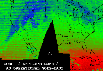
GOES-8 to GOES-12—It’s More than Adding Four
by Terri Gregory, SSEC Public Information Coordinator
This issue of SSEC In the News covers news and research results primarily from April 2003. Use images freely with credit to the Space Science and Engineering Center, University of Wisconsin–Madison, but please notify SSEC’s Public Information Officer.
On April 1, 2003, the Geostationary Operational Environmental Satellite (GOES)-12 replaced GOES-8 as GOES-East, the geostationary weather satellite covering much of the U.S. and Canada and all of South America. A host of changes were needed to efficiently generate products from the new instruments. Each time a new satellite is brought into service, especially if there are instrument changes, many steps must be performed to ensure continuity. The goal is to make sure that the public and the scientific community is served at least as well with the new satellite as the one it replaces.
GOES-12 is different from GOES-8, launched in 1994, with different channels taking information from different places in the electromagnetic spectrum. It is a nontrivial task to make products, based in software, work with a new satellite with a new set of instruments. SSEC, especially its Cooperative Institute for Meteorological Satellite Studies, has a long history of developing weather satellite instruments and of simulating satellite imagery for individual instruments. While NOAA and its National Environmental Satellite, Data, and Information Service made the actual transition from GOES-8 to GOES-12, SSEC’s CIMSS researchers and its Data Center are helping to make the process go smoothly.
One task necessary in validating a new satellite is intercalibration, where the abilities of the two satellites to measure radiation are compared. Preliminary intercalibration results produced by CIMSS’ Mat Gunshor show favorable comparisons between GOES-12 and NOAA’s polar orbiting satellite NOAA-15 instruments, the High-resolution Infrared Radiation Sounder (HIRS) and Advanced Very High Resolution Radiometer (AVHRR) in both infrared window and water vapor channels.
SSEC’s Data Center has archived satellite data since the Global Weather Experiment (also known as FGGE) in 1978 and became the National Archive for GOES data in December 1979. Besides archiving satellite data, they serve data users, and note that three main changes were made in the imaging instrument on GOES-12:
- The resolution of the GOES-12 water vapor channel (i.e., channel 3) is 4 km, as opposed to 8.
- The central wavelength of the GOES-12 water vapor channel is 6.5 um as opposed to 6.7 um on earlier satellites. The spectral response of the GOES-12 water vapor channel is also wider than those of GOES 8 through 11.
- Channel 5 (the 4 km resolution 12 um channel on pre-GOES-12 satellites) is replaced on GOES-12 by channel 6 (a new 8 km resolution channel centered at 13.3 um).
For More Information:
Products for GOES-12—Jim Nelson and Tony Schreiner (CIMSS) and Gary Wade and Tim Schmit (NOAA, stationed at SSEC) made the following products compatible with GOES-12: Clear Sky Brightness Temperature (CSBT) that is used in global numerical models to better define the upper-level moisture field, information from the GOES sounder radiance measurements (both separate and multiple bands), cloud-top information from the sounder that is used both by modelers as well as aviation forecasters, temperature retrievals, and associated Derived Product Imagery (DPI). The team deriving wind measurements from satellite observations, led by Chris Velden, also made their products compatible with GOES-12.
 |
Click on image for a more complete comparison. |
Tony Schreiner, Jim Nelson and Tim Schmit are now routinely producing a GOES-12 Sounder cloud product. Comparisons of the GOES-12 and GOES-8 products show that they are similar, but that in regions of high clouds the GOES-12 Sounder cloud product is less noisy and is slightly more sensitive to lower clouds. The switch from GOES-8 to GOES-12 took place on April 1 around 18:00 Universal Time Coordinated (UTC).
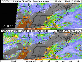
Comparison of GOES-12 (top) and GOES-8 (bottom) cloud top pressure. Overall they are similar, but in regions of high clouds the GOES-12 Sounder cloud product is less noisy (note high clouds off the East Coast of the United States and southern Indiana) and is slightly more sensitive to lower clouds (note clouds in Louisiana). |
CIMSS’ Wayne Feltz is validating near real-time derived products (total precipitable water vapor (TPW), cloud top pressure, lifted index and others) from GOES-12 sounder radiances. Near real-time validation using meteorological and surface-based remote sensing observations from the Department of Energy’s (DOE) Southern Great Plains (SGP) site continues. GOES-12 physically retrieved TPW are useful in adjusting the first guess water vapor values to more closely fit those observed at the Lamont, Oklahoma DOE ARM Central facility.
CIMSS scientists worked with NOAA’s National Center for Environmental Prediction (NCEP) personnel to assimilate GOES-12 Sounder products into the Eta Data Assimilation System (EDAS), which produces weather analyses used in the NCEP forecast model, Eta. Tom Zapotocny and Jim Jung (CIMSS) helped to verify data distribution, timing, quality and quantity of GOES-12 Sounder 3-layer Precipitable Water and the single field-of-view cloud product to ensure a smooth transition from GOES-8 to GOES-12. The GOES-12 Sounder 3-layer Precipitable Water product is now used in the operational EDAS. The GOES-12 Sounder cloud product is currently in the parallel EDAS and will be in the next version of the operational EDAS.
Tony Schreiner, Tim Schmit and Gary Wade now routinely process the GOES-12 Imager cloud product using the Carbon Dioxide (CO2) Absorption Technique (CAT). Every three hours a hemispheric image of Cloud Top Pressure (CTP) and Effective Cloud Amount (ECA), utilizing every field of view, is generated. The advantage of using the CAT is to provide a realistic definition of CTP and ECA for high, thin clouds.
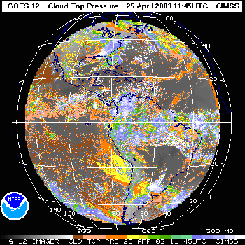
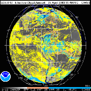
Cloud-top pressure, left; effective cloud amount, right
WF-ABBA Transfer—Chris Schmidt (CIMSS) and Elaine Prins (NOAA, assigned to SSEC) successfully transferred the GOES Wildfire Automated Biomass Burning Algorithm (WF_ABBA) from GOES-8 to GOES-12 on April 1 at NOAA’s National Environmental Satellite, Data, and Information Service (NESDIS) Operations as well as at CIMSS. The WF_ABBA product is being distributed to users from NOAA/NESDIS Operations as part of NOAA’s Hazard Mapping System (HMS).
Distance Learning—With aid from CIMSS and NOAA GOES experts at SSEC, Scott Bachmeier (CIMSS) conducted a beta test for the newly developed Virtual Institute for Satellite Integration Training (VISIT) teletraining lesson “Introducing GOES-12” on March 31, with reviewers from NOAA’s National Weather Service (NWS) and its VISIT program. This training material was offered to the NWS when GOES-12 replaced GOES-8 as the operational GOES-East satellite. Bachmeier gave the new lesson for the first time on April 11. Eight National Weather Service (NWS) offices participated in the distance learning lesson, with forty NWS staff attending.
Research to Operations—Making It Better
A National Academy of Sciences report commissioned jointly by NASA and NOAA urges a faster movement of satellite data and other technology into operational use. To this end, the authors recommend that a new interagency office be established to facilitate the quick transfer of NASA earth science research to NOAA operational use, when appropriate. Chris Velden, SSEC researcher who leads tropical cyclones activities at CIMSS, served on the National Research Council panel that wrote the report with several weather experts, including William L. Smith, formerly CIMSS director, now chief atmospheric scientist at NASA’s Langley Research Center.
The New York Times’ Warren Leary summarized the report and noted that a more efficient pathway could be found to move research results to operational use, potentially saving the public millions of dollars and scores of lives.
The NAS report is being published as a book and will be available through the Web site. Only the reports thought to be the most important become books.
Antarctica
“Nowcast,” a column in BAMS (April 2003), highlights the analysis, “Forecasting for Antarctic Rescue.” The authors explain the forecasting process used to assist the late-season flight that evacuated ailing doctor Ronald Shemenski. They analyzed the performance of the four numerical models used, and discovered that those best at predicting when winds would subside were the European Centre for Medium-Range Weather Forecasts global forecast model (ECMWF) and the Antarctic Mesoscale Prediction System Polar model based on the fifth-generation Pennsylvania State Univeristy-National Center for Atmospheric Research Mesoscale Model (AMPS Polar MM5). Matthew Lazzara was a co-author on the analysis.
A second icebreaker was called upon in a year of unusually thick ice around Antarctica. According to The Antarctic Sun (January 19, 2003), the icebreaker Healy, normally used in the Arctic, came to the aid of the Polar Sea to “help escort supply vessels through … the unusually thick and extensive ice.” Meteorologist Matthew Lazzara, one of several Antarctica researchers who contributed to the story, noted that last year, a severe storm cleared out some of the heavy ice. This year, he said, the weather was more normal, at least until the time of the story.
Annual meeting *note:this link now refers to the most recent annual meeting* — The Antarctic Automatic Weather Station (AAWS), Antarctic Mesoscale Prediction System (AMPS), and Antarctic Meteorological Research Center (AMRC) projects will host their joint annual meeting in June, from the 23rd to 26th in Madison, Wisconsin. Details are on the Web site.
Data and Imagery
A MODIS image of dust blowing north from Mexico into the U.S. was featured by NASA’s Earth Observatory. The dust event occurred on Wednesday, April 15 and was captured by the MODIS instrument on NASA’s Aqua satellite and broadcast and processed by SSEC.
SSEC’s global montage is used in the Biennial Report for 2000-2002 of the Lamont-Doherty Earth Observatory at Columbia University. The image from November 8, 2002, was used as “a snapshot of Earth” to illustrate a sidebar on climate change.
SSEC Data in Tokyo Museum—SSEC provides the weather satellite imagery that is seen in this gigantic globe showing the world’s weather. Visitors to Tokyo’s Museum of Emerging Science and Innovation can see the weather in real time using data from SSEC. The globe, a product of GeoCosmos, is covered with hundreds of LEDs.
 |
This giant globe hangs in Tokyo’s new science museum. SSEC provides the satellite weather data used to show changing weather patterns in real time. (Photo by Wendy Crone, College of Engineering, UW–Madison) |
The PSIgate Physical Sciences Information Gateway, University of Manchester, England, has added theSSEC Home page to their Web site. According to the PSIgate team, “PSIgate is a free online catalogue of high quality Internet resources in the physical sciences. Resources are selected, catalogued and indexed by researchers and other specialists in their respective fields.” Other SSEC sites already in PSIgate include the Antarctic Meteorological Research Center. PSIgate appears to be an amazing resource for science sites from across the globe.
“ New” McIDAS Image Gallery—A collection of images made with SSEC’s McIDAS software are now available on the SSEC Gallery page. This McIDAS retrospective contains dozens of images showing McIDAS capabilities of the 1990s. You may use them if you credit SSEC.
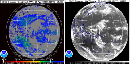
GOES-9 Unstored
SSEC’s Data Center is assisting in preparations for the transfer this month of Pacific Ocean geostationary weather satellite coverage from GMS-5 to GOES-9. After hardware and firmware modifications to the satellite modem, SSEC was able to acquire the GOES-9 Imager signal via the AMC-4 communications satellite. SSEC began archiving GOES-9 imager data onto tape at 1518 UTC on April 23. SSEC also is sending the raw data to the National Climate Data Center (NCDC) online archive via Internet 2. Image quality is comparable to previous data from GOES-9. Dee Wade manages the SSEC Data Center, Jerry Robaidek supervises its daily operations, and Tim Schmit of NOAA leads the GOES team at CIMSS.
With the resurrection of the GOES-9 Imager stationed over the western Pacific (subsatellite point of 0 north latitude and approximately 155 east longitude), the opportunity to produce Clear Sky Brightness Temperature (CSBT) data is now a reality. Routine generation (hourly) of this experimental product is expected to begin no later than May 1. Spatial resolution will be the same as CSBT data for GOES-10 and GOES-12.
Field Experiments and Meetings
THORPEX—Several CIMSS scientists, including Steve Ackerman, CIMSS director, participated in THe Observing-system Research and Predictability EXperiment (THORPEX) in Hawaii. A dozen flight missions were flown between February 27 and March 15. Several aircraft missions were dedicated to evaluating the performance of the Moderate Resolution Imaging Spectroradiometer (MODIS) and the Atmospheric Infrared Sounder (AIRS) instruments flown on the Aqua satellite. Several flights were coordinated with the NOAA Gulfstream IV aircraft for Winter Storms Research Program data assimilation studies. In support of these objectives, the University of Wisconsin Scanning High Resolution Interferometer Sounder (Scanning-HIS) was flown on the ER-2 high-altitude NASA aircraft. CIMSS scientists also provided mission forecasting and flight planning.
Instrument Development
Microwave instruments—Following a science team meeting, NASA released news on the utility of the Aqua satellite’s microwave instruments, the Atmospheric Infrared Sounder (AIRS) and the Advanced Microwave Sounding Unit. Hank Revercomb said that the instruments provided “a virtual gold mine of information.” The instruments create “a global, three-dimensional map of atmospheric temperature and humidity. AIRS provides information about clouds, greenhouse gases and many other atmospheric phenomena.” As new data products become available from this new microwave system, NOAA is evaluating the data for use with numerical forecast and climate models.
Chris Richard, Los Angeles correspondent with New Hampshire’s Weather Notebook radio show, interviewed Hank Revercomb on the utility of AIRS data.
Neutrino News
Nature—Geoff Brumfiel reported on AMANDA in the journal Nature, from the American Physical Society’s annual meeting in Philadelphia in April 2003. Brumfiel explained the workings of AMANDA and noted that a larger, kilometer-sized telescope (IceCube) was planned to be able to get a more exact fix on the neutrinos’ origin. The article Web page links to more IceCube, AMANDA, and other neutrino telescope stories.
P.M.—A long, popularized article on IceCube appeared in the German magazine, P.M. It calls IceCube, “The largest experiment in the world.” Christian Speiring, a physicist involved in the experiment, is quoted in the article. Headquartered at the University of Wisconsin–Madison’s Space Science and Engineering Center, IceCube pools the talents of physicists around the world, including those at UW–Madison’s Department of Physics.
In an article on research funding, Science News (February 8) notes that a large portion of the National Science Foundation’s budget is devoted to new research facilities, mentioning IceCube.
Nifty Software
The Why? files has released Twister: The Tornado Story, with all sorts of useful information about tornadoes—what causes them, how to protect yourselves from them, and how to make them. That’s right. Directions are given to make a “tornado in a bottle,” and you can make your own virtual tornado with software designed by Tom Whittaker with input from Steve Ackerman. Warning: it’s habit forming.
Tim Schmit (NOAA) and Jim Nelson (CIMSS) provided specialized McIDAS software to both NASA’s Langley Research Center and to Unidata. This software has a number of options, including progressive image averaging. The software provides a starting point for minimizing the GOES-9 high frequency noise in the visible channel, and can currently be used to produce a loop of satellite images showing the benefits of higher spatial resolution data. UNIDATA used this software to create a visualization for presentation to congressional staffers.
The software tool, ICE, was unveiled last month in NASA’s Earth Observatory Web site. Since then, the nifty tool has garnered praise from users, including Bruce Hoglund. Among other nice things, he says, “My tax money well spent indeed! Math, science, geography, social studies, etc. teachers who don’t use this site to teach their subject areas are missing out. Just the ability to play with 3 variable 3 dimensional graphs (your 3D scatter plots), oh my!” Hoglund was drawn in by the Channel Islands demonstration.
Polar Science
Arctic Clouds—In last month’s In the News we noted that a paper by Jeff Key and Xuanji Wang is being published in Science. We missed a link to an article by Harvey Black, reporting for United Press International. Black compared Key and Wang’s research on cloudiness in the Arctic with research on atmospheric carbon dioxide. In studying ice age cycles, climatologists at Scripps Institute of Oceanography say that carbon dioxide increases lagged behind temperature warming by hundreds of years. Wang and Key are also interested in global change. In this case, their data show that clouds seem to slow down warming.
The Houston Chronicle (April 6, 2003) reported that Key and Wang examined changes in climate above the North Pole between 1982 and 1999 and found a significant warming trend that is producing profound weather changes in the Arctic. Among the changes are reduced sea ice and glaciers, earlier spring snow melts, thawing of permafrost, increasing sea levels and more coastal erosion, affecting fishing, habitat and living conditions in the region and foretelling serious weather variations for northern climates. (University Communications’ University Newsmakers)
Wisconsin Week Wire featured the story on March 19 and Wisconsin Week (print) on March 26. TheTranscript, a Norman, OK newspaper, and Science News (March 22) also featured the study.
Tracking Fires
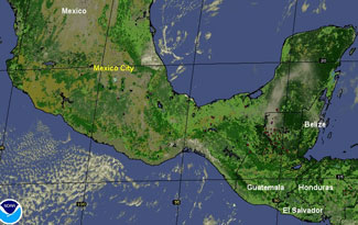
WF-ABBA—The annual agricultural burning season has begun in Mexico and Central America with hundreds of fires burning throughout the region especially in the Yucatan Peninsula. The GOES-8 Wildfire Automated Biomass Burning Algorithm is documenting the diurnal fire activity (the process of burning that occurs throughout the day) and this information is being used to support a multinational effort to study air pollution in megacities around the globe. The Integrated Program on Urban, Regional, and Global Air Pollution (led by the Massachusetts Institute of Technology) is focusing initial research efforts on Mexico City including atmospheric modeling, health and risk assessment, and transportation, land-use, and urban development. Researchers Elaine Prins (NOAA) and Chris Schmidt (CIMSS) are using the Wildfire ABBA fire product to distinguish between air pollution from urban sources and from biomass burning.
 |
The animation shows agricultural burning as detected with the GOES Wildfire ABBA from 17:15 to 20:45 UTC on March 20, 2003. |
GOES-8 Automated Biomass Burning Algorithm (ABBA) fire products for June through October 2002 indicate that the amount of burning during the 2002 fire season in South America was more than 25% higher than observed in 2001 and 50% higher than 2000. Much of this fire activity occurred late in the fire season with more than 375,000 fire pixels detected by the GOES-8 ABBA at 11:45, 14:45, 17:45, and 20:45 UTC. Elaine Prins (NOAA) and Joleen Feltz (CIMSS) are integrating these results into an 8-year GOES-8 fire, smoke, and cloud climatology to characterize diurnal, spatial, seasonal and interannual trends in South America. The study area extends from 0 to 40°S and from 35 to 75°W and includes portions of Brazil, Peru, Bolivia, Paraguay, Uruguay, and northern Argentina.
Weather Research
Modeling—Bob Aune (NOAA, at SSEC) is evaluating the use of cloud-top pressure and effective cloud amount retrievals from the MOderate Resolution Imaging Spectrometer (MODIS) for cloud water initialization over the Pacific region using the CIMSS Regional Assimilation System (CRAS). Further evaluation will be conducted to determine if the MODIS data can be used simultaneously with cloud retrievals from the GOES sounders.
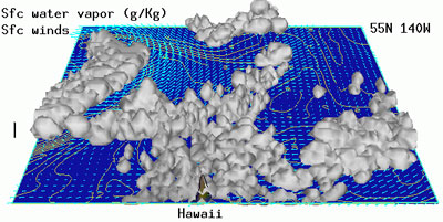 |
The 3-dimensional cloud water, surface mixing ratio (g/Kg) and surface winds at the end of a 6-hour CRAS forecast cycle that incorporated cloud information from seven 5-minute MODIS granules. The clouds shown result from MODIS information only as the cloud physics in the CRAS was disabled during this test. |
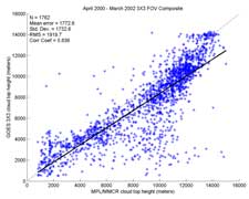
Cloud Top Pressure—James Hawkinson (CIMSS) performed an objective comparison of the GOES Sounder Cloud Top Pressure (CTP) product with an independent source as a Master of Science thesis topic. Hawkinson compared the GOES cloud product with cloud-top height retrievals from a ground-based micropulse lidar (MPL) and a millimeter cloud radar (MMCR) from the Cloud and Radiation Test Bed (CART) site in Lamont, Oklahoma. He used two years of GOES Sounder CTP data and MPL/MMCR data from March 2000 to April 2002. Rapid Update Cycle (RUC) computer model output was used to convert the cloud top pressure output (in millibars) from the GOES sounder into height-above-ground units (in meters above ground) used by the MPL/MMCR for comparison.

The two figures compare the GOES cloud top pressure (CTP) with the micropulse lidar/millimeter cloud radar (MPL/MMCR) for the 3×3 GOES product (left) and the GOES single field-of-view (SFOV, right). The SFOV product compares as favorably with the MPL/MMCR product as the 3×3 GOES product. The tendency for the GOES to have lower cloud tops than the MPL/MMCR is consistent with the physics of the two measurements.
New Funds
The National Science Foundation has accepted for funding “Interactions Among Observations of Laterally Advected Heat and Moisture, Cloud Properties, Surface Temperature, Surface Radiation Fluxes, and Net Precipitation in the Arctic.” Proposal investigators are J. Francis (Rutgers University) and J. Key (NOAA at SSEC). In the study, a CIMSS graduate student will study the relationships between cloud properties and large-scale advection.
The Joint Center for Satellite Data Assimilation will fund “Polar winds data assimilation experiments.” The project investigators, Jeff Key and Chris Velden will work closely with NASA’s Data Assimilation Office on assimilation of polar winds from the Moderate Resolution Imaging Spectroradiometer (MODIS).
Papers, Presentations
David Turner, B. M. Lesht, S. A. Clough, J. C. Liljegren, Henry Revercomb, and David Tobin. Dry bias and variability in Vaisala RS80-H radiosondes: The ARM experience. Journal of Atmospheric and Oceanic Technology, volume 20, no.1, 2003, pp.117-132.
Daniel Zhou, William Smith, Jun Li, Hugh B. Howell, Greg Cantwell, Allen Larar, Robert Knuteson, David Robin, Henry Revercomb, and Stephen Mango. Thermodynamic product retrieval methodology and validation for NAST-I. Applied Optics, volume. 41, no. 33, 2002, pp. 6957-6967.
“Detection, modeling, and impacts of biomass and oil fires” was submitted by J. Reid (Naval Research Laboratory, Monterey, CA) and Elaine Prins (NOAA) to the BACIMO conference to be held in Monterey, CA in September. The primary objective of the conference is increased cooperation and coordination in all aspects of atmospheric, weather and cloud impacts on military operations and for civilian applications, both in the U.S. and internationally. The abstract focuses on applications of the real-time Navy Aerosol Analysis and Prediction System (NAAPS) to diagnose and predict aerosol transport, including an overview of real-time assimilation of the GOES Wildfire Automated Biomass Burning Algorithm (WF-ABBA) fire products.
Education, Outreach
GLOBE—From Gallaudet Model Secondary School for the Deaf in Washington, DC, science teacher Mary.Ellsworth thanks Sanjay Limaye, director of SSEC’s Office of Space Science Education for interesting her students in earth science. She said that his “discussion with the students has been the basis for our work since the day you were here [this past winter]. We have built on that to talk about the Earth’s energy budget, and to understand the electromagnetic spectrum.” Ellsworth and her students are part of GLOBE and have been using the Sun Photometer in their classes. A professor in Gallaudet University’s Chemistry and Physics Department is also considering its use in class activities.
Science Expeditions—SSEC’s AERIbago and IceCube were featured exhibits in “Whys and Wows!,” the inaugural event in UW–Madison’s Science Expeditions. The Madison campus hosted a month of science exhibits and open houses spanning the life and physical sciences. Whys and Wows on April 5 featured about 20 “Explorations Stations” in and in front of the College of Engineering’s main building. About 700 visitors attended the exhibits and talks. A MODIS image of Iraq posted on the AERIbago and taken April 2 drew many comments.
Satellite meteorology lessons—Margaret Mooney, SSEC’s Office of Science Education, presented new satellite meteorology lesson-preparation material at the annual convention of the Wisconsin Society of Science teachers (WSST) on March 11th. The break-out session attracted 38 teachers of middle and high school science. Co-presenter high school teacher Jay Affekdt said that the best part was the “oohs” and “ahs” when they demonstrated various hands-on activities.
Science writer visit—SSEC was pleased to host science writer Glennda Chui for a discussion on April 11. Chui, a veteran, award-winning science reporter for the San Jose Mercury News, was on campus as the spring 2003 science writer in residence. Her background encompasses the many issues facing Silicon Valley as well as many national matters, including the Hubble Space Telescope. She is known to university scientists and engineers who worked on the HST.
Honors
Hagemeyer Award—Christopher Velden, CIMSS researcher who leads the Tropical Cyclones group, has received the Hagemeyer Award sponsored by the Office of the Federal Coordinator for Meteorology within the National Oceanic and Atmospheric Administration. Robert DuMont, director of the Interdepartmental Hurricane Conference in (IHC). The Award honors Dick Hagemeyer, the patriarch of the IHC and the long-time Director of the National Weather Service Pacific Region. Velden is the second recipient, presented for his service to the international hurricane research community. Velden has actively sought to improve hurricane forecasts through weather satellite research since 1980. The award was mentioned in Wisconsin Week, April 23.
NMSC Guest Scientist—Jun Li, a scientist in CIMSS, has been named “guest chief scientist” in satellite atmospheric sounding by China’s National Satellite Meteorological Center, the first scientist outside of the center awarded this title. According to Wenjian Zhang, Director General of NSMC, “Dr. Jun Li’s research work, talent, and publications on atmospheric remote sounding during the past 10 years are highly recognized at NSMC.” Li is also recognized for promoting cooperative research between NSMC and UW–Madison’s SSEC in processing and applying data from both U.S. and Chinese weather satellites. The honor was noted inWisconsin Week, April 23..
Suomi Scholarships—The Cooperative Institute for Meteorological Satellite Studies (CIMSS) is pleased to announce the winners of the sixth annual Verner E. Suomi Scholarship Award for Outstanding Achievement in the Physical Sciences:
- Kevin Eichinger of Oshkosh West High School (Oshkosh, WI) intends to major in Mechanical Engineering at either the University of Wisconsin-Madison or University of Wisconsin-Platteville
- Jenna Helbing of Platteville High School (Platteville, WI) intends to major in Mathematics Education at the University of Wisconsin-Eau Claire
- Amanda Kis of Kettle Moraine Lutheran High School (Jackson, WI) intends to major in Meteorology at the University of Wisconsin-Madison
- Theodore Lyons III of Milton High School (Milton, WI) intends to major in Meteorology at the University of Wisconsin-Madison
CIMSS and the National Oceanic and Atmospheric Administration (NOAA) have offered the Suomi Scholarship since 1998 as a way to honor Professor Verner E. Suomi’s lifelong commitment to the education of undergraduate students. This year more than 20 students applied for the prestigious award—a $1000 scholarship recognizing outstanding achievement in the physical sciences. To be eligible a student must be a graduating high school senior who plans to attend a University of Wisconsin–System undergraduate program in the physical sciences, especially meteorology, earth science, oceanography, physics, astronomy, science or math education, and environmental science.