Monthly News Summary – April 2003
Clouds May Mitigate Warming
by Terri Gregory, SSEC Public Information Coordinator
This issue of SSEC In the News covers news and research results from January, February and till mid-March 2003. Use images freely with credit to the Space Science and Engineering Center, University of Wisconsin–Madison, but notify Terri Gregory.
Scientists Xuanji Wang (UW–Madison) and Jeff Key (NOAA, at SSEC) have analyzed data showing that clouds over the Arctic regions “and the climate conditions with which the clouds interact produce a cooling effect, possibly offsetting to some degree the effects of global warming in this region.” Their paper, “Recent Trends in Arctic Surface Cloud and Radiation Properties from Space,” is published in Science, March 14. Emily Carlson, University Communications, UW–Madison released the news concurrently.
Wang, a graduate student in the Department of Atmospheric and Oceanic Sciences, lead author on the Science paper, and Key, team leader in the NOAA research group at SSEC, analyzed changes in surface albedo (reflectivity) and temperature along with cloud coverage from 1982–1999. They are among the first to study the interactions of changes in climate and weather, such as cloud cover with surface temperature and albedo.
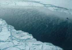 |
Steam fog rises above a sea ice fracture in the western Arctic Ocean, north of Alaska, during the fall of 1995. Linear fractures in the sea ice form primarily in response to wind stress. The fog forms when cold air over the ice meets the warm, moist air over the open water. (Taken out of an airplane window at about 200 feet above the ice by Jeff Key.) |
Using satellite data collected across the Arctic, Wang and Key determined the amount of cloud forcing, the warming or cooling effect of clouds that depends on interactions among various atmospheric factors, for each season and annually. They found a complex interplay of cloud cover with a variety of factors. Although some of the trends they found are small, Key said that even small changes can signal climate change elsewhere and that “The Arctic is a place where small changes can have big effects.” Wang said, “We have added new information on how the climate responds to warming by looking at parameters not previously examined.”
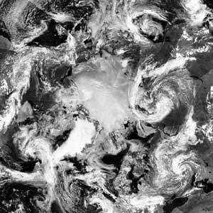 |
The Arctic Circle, from polar-orbiting weather satellite data. |
Articles appeared on March 14 in the Wisconsin State Journal by Anita Clark, in the Milwaukee Journal Sentinel by John Fauber, and on the United Press International Web site by Harvey Black.Science News will publish Sid Perkins’ version later in March. Clark stressed the idea that the Arctic, while it may seem far away, influences the planet’s weather. In Fauber’s piece, Arctic climate expert Judy Curry said that Wang and Key’s research “may help improve models for predicting global climate change by helping to incorporate the impact of clouds.” Black analyzed the Wang/Key research with a study of ancient patterns of CO2 forcing (increased atmospheric CO2). Both studies, he said, are adding further insights for computer climate modelers.
Key is a co-author on another paper on cloud forcing, with co-authors Michael Pavolonis (CIMSS) and J. Cassano (University of Colorado). “A Study of the Antarctic Surface Energy Budget Using a Coupled Regional Climate Model Forced with Satellite-Derived Cloud Properties” was submitted to Monthly Weather Review. The paper presents results from a study of forcing a regional climate model with satellite-derived clouds over Antarctica.
Columbia Lost
SSEC staff provided background to media following the disastrous loss of the Space Shuttle Columbia and her crew. Scott De Laruelle of the Daily Cardinal, a campus student newspaper, spoke with scientists Wilt Sanders, senior scientist in SSEC and space physics, and Sanjay Limaye, planetary scientist and director of SSEC’s Office for Space Science Education. Both scientists stressed the importance of moving forward. According to Sanders, who was principal investigator on the Diffuse X-ray Spectrometer experiment that was held back after the 1986 Space Shuttle Challenger disaster, “we may have to accept that risk is part of the cost of space exploration by humans.” Limaye concurred, adding, “this [space exploration] is an investment in our future.”
The Badger Herald, another campus student newspaper, interviewed Bob Paulos, executive director of SSEC’s Antarctic Astronomy and Astrophysics Research Institute and program manager of the DXS. Paulos commented on the effects of Columbia’s loss on the space program itself. He noted that the Challenger disaster “caused trepidation with officials” and he speculated that officials could again become cautious. He noted that astronauts “face tremendous risk in the name of science.”
David Steinkraus, Racine’s Journal Times, analyzed the space shuttle tragedy from the terms of the loss to science, not only the tragic loss of seven brilliant lives. He interviewed physiologist James Ferraro at Southern Illinois University School of Medicine and Wilton Sanders. Both have led projects that were set back by Challenger’s loss. Ferraro that science can’t move forward without results from experiments. If the experiments depend on the Space Shuttle, and are lost, results are lost as well. Sanders noted that delays can cost interest in a once timely topic. DXS was a year away from launch when the Challenger exploded. From the time the project was proposed to the time it finally was able to be launched, to the time a paper analyzing the data was published, was 20 years. Bob Paulos thought that “this isn’t going to be like 1986,” and that the investigation would proceed much more quickly. He is concerned about the possible impact on NASA’s budget, with a Columbia replacement costing possibly $2 billion. He also thinks that “if the accident causes us to stop and think” about possible solutions, “These astronauts will not have died in vain.”
Jim Nelson, Chris Schmidt, Dave Stettner, and Chris Velden (CIMSS) and Tim Schmit (NOAA, at SSEC) collaborated with Doris A. Rotzoll of the National Weather Service (NWS) Spaceflight Meteorology Group (SMG) at Johnson Space Center in Houston in providing meteorological data to aid in Space Shuttle Columbia debris recovery efforts and to help determine weather conditions before and at the time of the loss. CIMSS supplied various products derived from GOES data, including winds, temperature, and moisture, to the SMG. Collaborators discussed other potential data sources, including the MODerate-resolution Imaging Spectroradiometer on NASA’s Terra satellite, NOAA Polar Orbiting Environmental Satellite systems, and numerical model analyses.
Antarctica
ICDS and ITASE—In a story on science at the South Pole, Milwaukee Journal Sentinel’s Ernest Mastroianni quotes Charles Bentley (UW–Madison professor emeritus in geophysics and ICDS principa investigator) and notes the role of SSEC’s Ice Coring and Drilling Services. Paul Maylewski, principal investigator of the U.S. component of the 19-nation International Trans-Antarctic Scientific Expedition, said the drillers made the project possible. The piece appeared in the paper’s Health and Science section, January 13. Mastroianni traveled to Antarctica as a journalist.
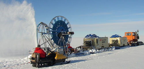
ICDS’ new Shot Hole Drill at work. It can drill more than 75 meters deep.
In a March 7 article in Newsday, Charles Bentley drew on new evidence about melting ice in Antarctica. He said that, although the Larsen Ice Sheet is losing ice, he and other experts believe that “the West Antarctic Ice Sheet [the bulk of the continent] is not going to disappear within the next few hundred years.” The new ice research was noted in Wisconsin Week, March 12.
Working in Antarctica—AMRC’s Matthew Lazzara and George Weidner and Jonathan Thom of UW–Madison’s Automatic Weather Station Program returned to Antarctica this austral winter, joining a record number of approximately 1500 U.S. researchers and support staff on the continent. Lazzara’s Antarctic journal gives details of their stay, beginning on January 8 when Lazzara described his journey south to “the Ice” and told about his work as a meteorologist studying Antarctica‘s weather. Primarily he studied fog, which has a large impact on flights to and from Antarctica. He collected samples of fog to compare with data received via satellite.
Activities in Antarctica included giving the Wednesday Science Lecture. Lazzara’s talk included the state of Antarctic Meteorology, UW–Madison’s work with icebergs and his own research on fog. He upgraded computer systems at the Antarctic Meteorological Research Center (AMRC) at the Crary Science and Engineering Center to better collect, process and archive weather data. Lazzara was even able to do some forecasting, working with Long Duration Balloon forecaster, Glenn Rosenberger. Lazzara provided the LDB group with AMRC data, which they’d not previously used.
Weidner and Thom repaired and replaced several weather stations (AWS). They raised the AWS called Schwerdtfeger clasping a new tower to the existing tower. Next year Weidner hopes to replace the whole station, giving it a new boom, batteries, sensor suite, and possibly new electronics.
Lazzara and Weidner helped host a large congressional delegation, part of the House Science Committee that oversees National Science Foundation funding. Among the visitors was Sherwood Boehlert, committee chair, who said of the Antarctic program, “I think it’s working exceptionally well, and in terms of things like weather, climate change and environmental issues, this research is important to every living person on the face of the earth.” (reported by CNN)
Matthew Lazzara and George Weidner provided information for a story in The Antarctic Sun on the Healy icebreaker’s trip to Antarctica in January 2003. The U.S. Coast Guard icebreaker Healy helped escort resupply and refueling vessels through the unseasonably thick sea ice. Lazzara noted that ice is more extensive and much thicker than usual. He expects that the extra ice is likely due to the big icebergs nearby, shading that part of the ocean.
Matthew Lazzara appeared live on WORT-FM radio on January 30, on Dennis Shaffer’s Thursday evening science show. Calling in from Antarctica, Lazzara explained his work and answered questions about the NSF-funded Antarctic program.
AMRC’s Shelley Knuth provided background and images to Madeleine Nash, a journalist in Antarctica, for an article in TIME magazine for February 3, 2003. Knuth’s input regarded the large tabular icebergs that have calved from the Ross Ice Shelf and that AMRC has monitored since 2000.
Data and Imagery
Great Lake’s ice—GOES-8 visible imagery showed the extent of pack ice that had formed in Lake Superior during February 2003, when colder than normal temperatures were experienced across the western Great Lakes region. The GOES-12 visible band showed the ice pack more clearly than GOES-8. Terra’s composite imagery from the MODerate-resolution Imaging Spectroradiometer (MODIS) showed even greater detail, and also demonstrated how the use of multispectral imagery helps to distinguish the ice features from any areas of cloudiness that are also present. Image examples and animations area available on the CIMSS GOES Gallery.
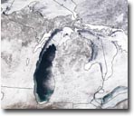 |
MODIS image, March 9, 2003, shows ice on several Great Lakes. |
NASA’s Earth Observatory features a new software tool in its Laboratory section—the Image Composite Editor, or ICE. The Image Composite Editor is a java applet designed by SSEC’s Tom Whittaker and Tom Rink to easily analyze remote sensing data via a Web browser. The Earth Observatory Web site gives interactive activities with which to use the tool. The ICE concept and interface design was provided by Tom Whittaker with Robert Simmon and David Herring of NASA’s Earth Observatory Team. Steve Ackerman and Scott Bachmeier of SSEC’s CIMSS provided scientific consultation with Wayne Esaias, NASA GSFC. The ICE tool was made possible thanks to funding support from Ernest Hilsenrath, NASA GSFC.
Year long-satellite movie—Patrick Francis of Kent State University’s Department of Geography has produced a year-long movie loop from SSEC’s global satellite infrared composite imagery. It covers all of 2002. Francis created his movie from 2,715 frames he downloaded from SSEC’s Web site. He uses the movie for classroom discussion and says it “provides for an excellent representation of global circulation patterns.” On his Web site, select “Global IR Satellite Composite Loop” from Free Weather Data.
UW–Madison’s Environmental Remote Sensing Center is using MODIS data from SSEC’s direct broadcast facility along with Landsat data to track lake clarity. As noted in the Wisconsin Week Wire for January 15, 2003, researchers and hundreds of volunteers around the state are assessing the water quality of Wisconsin’s lakes using the MODIS instrument on NASA’s earth observing satellite, Terra.
A Canadian Children’s Educations Series, “Canadian Geographic Kids,” will use the CIMSS GOES Gallery animation showing Hudson Bay freezing. This series is broadcast throughout Canada on the Aboriginal Peoples Television Network and on Canada’s educational stations. The image will be used in an episode on Churchill, Manitoba and Hudson Bay. We hope to receive a copy of the program for in-house viewing.
Plants all over the world—Dr. K. Marquardt of the Institut fuer Wirtschaftsoekologie in Dornstadt, Germany links to SSEC’s Data and Imagery page to help users of his extensive plantencyclopedia locate wildflowers all over the world.
Field Experiments and Meetings
GWINDEX-3—The 3rd GOES Rapid-Scan Winds Experiment (GWINDEX-3) is being conducted over the East Pacific Ocean. This experiment is again being coordinated by CIMSS (Chris Velden and Dave Stettner) and NOAA’s Forecast Products Development Team (J. Daniels), and will run through March. Winds derived from GOES-10 rapid scan imagery are being produced in real time and disseminated to National Weather Service forecast centers, as well as to the Pacific Landfalling Jets Experiment (PACJET) and The Observing System Research and Predictability Experiment (THORPEX) mission planning centers.
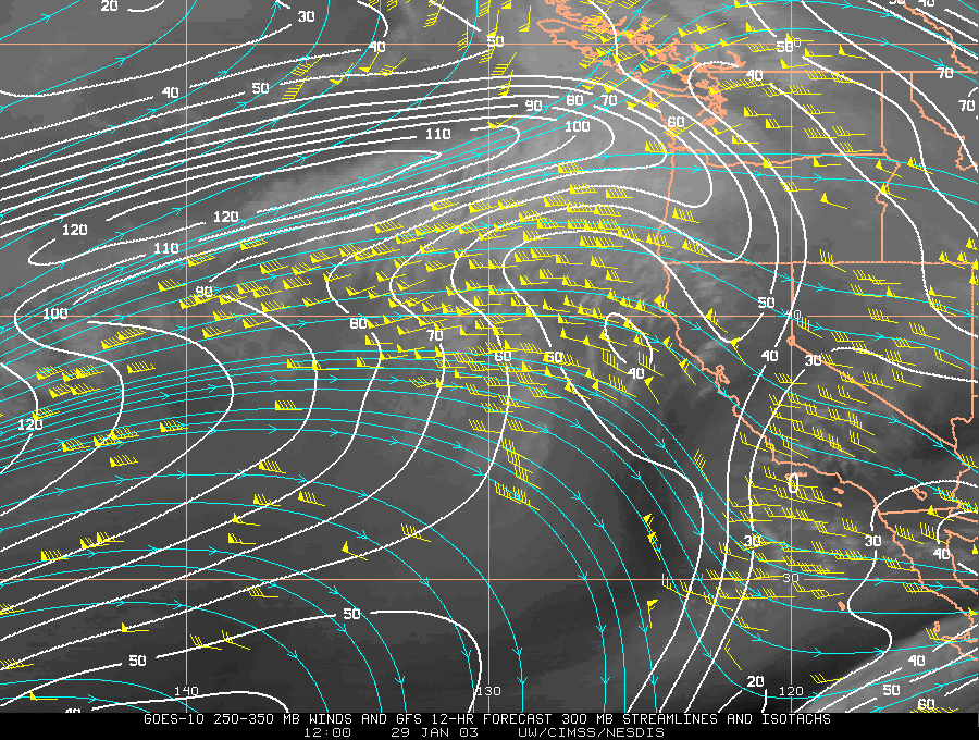 |
A new display product has been added to the GWINDEX-3 Web page. . This product overlays the model forecasts on the satellite winds to help the forecasters better evaluate model performance. Satellite-derived wind vectors and 12-hour model forecast isotachs and streamlines are plotted on a GOES-10 image for January 29, 2003. |
The CIMSS Regional Assimilation System (CRAS) forecast model is now running over the Central Pacific, supplying forecast guidance http://cimss.ssec.wisc.edu/model/pacific/pacific.html for aircraft participating in THORPEX. The CRAS is running at 40 kilometer resolution and is nested in the National Centers for Environmental Prediction’s Global Forecast System. Clouds and moisture information in the CRAS are taken from observations from the GOES-10 sounder and MODIS.
Annual AMS—SSEC attended and exhibited at the Annual Conference of the American Meteorological Society held in Long Beach, CA February 9–13. SSEC’s exhibit booth was advantageously positioned this year, directly at the entrance to the exhibit hall and across from NOAA. SSEC provided a few mementos, including fabulous MODIS images of California produced by researchers Kathy Strabala and Liam Gumley through SSEC’s direct broadcast facility. We also were able to give away a print provided by Cabela’s, the Midwest-based outdoors outfitter, and some Oscar Mayer wiener whistles, very popular items. We provided poster-sized California images as promotional items to Weatherfest, a public event held the day before the conference officially started.
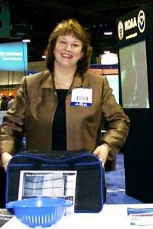
Elaine Prins (NOAA, assigned to SSEC) exhibits at NOAA booth across from UW–Madison booth. Click on each for a larger image.
SSEC, including CIMSS, authors made many presentations at the AMS Annual Conference. Tim Schmit presented a poster on the channel selection of the next generation imaging instrument. Elaine Prins presented a two-year analysis of fire activity in the western hemisphere as observed with the GOES Wildfire Automated Biomass Burning Algorithm. She also chaired the environmental applications section of the conference. Bob Aune presented an evaluation of water vapor and cloud retrievals from MODIS data over Antarctica. Other CIMSS presentations are listed in the NOAA ASPT weekly report for February 21. Reprints and a publications list of SSEC papers and posters can be found in The Schwerdtfeger Library.
Neutrino News
Good budget news—In February, the president released his budget for 2004 containing specific language authorizing “construction of IceCube, a South Pole facility to detect neutrinos.” The budget includes funding for IceCube at the level of $295.2M through FY2013. This includes construction and commissioning and four years of operation after construction. In the section devoted to the National Science Foundation, the budget document explains that “Neutrinos are one of the fundamental particles that make up the universe and are also one of the least understood.” See “Sharpening Tools for Science and Engineering.” Also see NSF: Detailed Budget Estimate.
The American Geophysical Union’s Science and Legislative Alert 03-03 noted that IceCube was specifically included in NSF’s Major Research Equipment and Facilities Construction account.
Per Olof Hulth, member of the IceCube consortium with Stockholm University, trusts that 2003 will see final IceCube approval. The group also hopes to have the first IceCube equipment arriving at the South Pole. A new hot water drill is expected to be sent autumn 2003. The first 20 sensor prototypes should be ready for testing during spring 2003. The year promises to be a busy one for all involved in IceCube.
The Annual Report 2002 of the University of Wisconsin–Madison lists IceCube in The Year in Review. In November 2001, it is noted that the “the university is slated to receive $15 million in federal funding for the first phase of … IceCube.”
Polar Science
Polar Winds—The real-time polar winds product derived by Chris Velden and Dave Santek (CIMSS) and Jeff Key and Paul Menzel (NOAA, at SSEC) from MODIS information became part of the ECMWF operational weather forecasting system on January 14, 2003. For the past few months the MODIS winds have been tested in the “E-suite,” the last pre-operational test of model, analysis, and data changes. Jean-Noël Thépaut of ECMWF stated that the 3D-Var (three-dimensional variational analysis) tests showed a dramatic improvement (better forecasts) when the polar winds were assimilated. The 4D-Var tests showed a smaller, but still globally positive, impact. He summarized the results by saying “the MODIS winds experience can be considered as a great success.”
Tracking Fires
WF-ABBA—Over the past 2 years the Geostationary Operational Environmental Satellite (GOES)-8 Wildfire Automated Biomass Burning Algorithm (WF-ABBA) has been used to monitor fire activity associated with new agricultural activity in Acre, Brazil along a new road being constructed across the Andes from Brazil to Peru. During the 2002 fire season a ground truth validation effort was conducted in Acre to determine the capability of the GOES-8 WF-ABBA to detect agricultural burning in the region. The GOES Wildfire ABBA correctly identified 84% of the 88 fires that were monitored by on-site survey teams; the majority of the fires not detected with the GOES WF-ABBA were obscured by clouds. This validation effort, prepared with Joleen Feltz (CIMSS) and Elaine Prins (NOAA, assigned to SSEC), was presented by K. McClaid-Cook (SUNY-Albany/ Universidade Federal do Acre) at the 99th Annual Meeting of the Association of American Geographers in New Orleans on March 7, 2003.
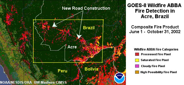
This GOES-8 Wildfire ABBA fire composite shows fire activity in western Brazil in the state of Acre from June through October 2002. Fires associated with deforestation and agricultural management are evident along a new road being built across the Andes from Brazil to Peru.
ABBA results—As part of an ongoing collaboration with the Brazilian Instituto Nacional de Pesquisas Espaciais (INPE), Joleen Feltz, CIMSS, and Elaine Prins, NOAA, compared GOES-8 Automated Biomass Burning Algorithm (ABBA) fire products with INPE fire products using NOAA AVHRR satellite data for the past seven fire seasons (1995-2001). Results show that the INPE AVHRR fire product detects more fire pixels in a single time period than the GOES-8 ABBA at that same time period, especially in the Cerrado (grassland) region where the fire intensities are generally lower than that observed in the forested regions. When comparing diurnal GOES-8 ABBA composites with the daily INPE AVHRR fire product, however, the GOES-8 ABBA typically detects 2 to 5 times as many unique fire pixels. This demonstrates the importance of high temporal (done often throughout a day) monitoring to capture agricultural burning in South America where the fire signals are often detectable by satellite for only a few hours.
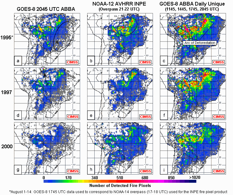 |
This caption is for the larger figure in which the INPE fire product using NOAA AVHRR data is compared to the GOES-8 ABBA fire product at 2045 UTC and the GOES-8 ABBA daily unique fire composite for the past seven years. The figure shows the comparison for 3 years: 1.) 1995, the most active fire season, 2.) 1997, another active season with a drought in Northern Amazonas and 3.) 2000, the least active fire season. The daily unique GOES-8 ABBA composite, consisting of unique fire pixels detected at 1145, 1445, 1745, and 2045 UTC (c,f,i), clearly shows that the extent and concentration of fire activity is much greater than that indicated by observing at a single time period by GOES (a,d,g) or AVHRR(b, e, f). |
Elaine Prins (NOAA, working with CIMSS) is collaborating with I. F. Brown (principal investigator, Woods Hole Research Center) and five co-investigators from the U.S., Brazil, and Peru on a newly funded NASA project, “Land-cover land-use changes in the tri-frontier area of Brazil, Bolivia, and Peru: implications for sustainable land use in southwestern Amazonia.” Prins and CIMSS researchers will produce a 5-year half-hourly fire product data set for South America, which will be made available to the research community for multiple land-use application studies. The GOES WF-ABBA fire results will be compared with fire products from instruments on polar orbiting satellites—MODIS and Advanced Very High Resolution Radiometer (AVHRR)—and ground truth in South America to better understand multisensor fire product applications and data fusion.
Weather Events
The National Weather Service Forecast Office in Sullivan, Wisconsin links from their home page to two CIMSS pages explaining the convective snow event of February 11, 2003. Scott Bachmeier explains the event using GOES and MODIS satellite imagery. Suzanne Wetzel Seaman posts a variety of “ingredients maps” that are tools to forecast snow and ice events.
Weather Experts
Weather Guys Steve Ackerman (Director, CIMSS and Professor, AOS) and Jonathan Martin (Professor, AOS) appeared on Larry Meiller’s WHA Radio show on Monday, February 24. They fielded questions on snow rollers—Mother Nature’s snow men, or snow jelly rolls, and on lightning, including fulgurites, the formations made by lightning striking sand. The Guys repeated that lightning flashes really do start from the ground up. Listeners called in observations of rainbows at night, green flashes (the Guys were jealous), and moon pillars (shaft of light flowing from the moon). The Weather Guys usually appear on the last Monday of every month from 11:45 a.m. to 12:30 CT. In and near Madison, you can listen to them at 970 AM or 90.7 FM You can also listen to them on the Web.
Weather Research
NOAA scientist Jeff Key has been appointed Team Leader of the Advanced Satellite Products Team, the branch of NOAA’s National Environmental Satellite, Data, and Information Serviceresearch group stationed at UW–Madison. The group works closely with SSEC scientists in the Cooperative Institute for Meteorological Satellite Studies. Jeff Key joined ASPT in 1999 and has been acting team leader almost 2 years. His research has focused on the polar regions and most recently on the development of a MODIS polar winds product.
CRAS Analysis—CIMSS is evaluating a snow-cover product, the Interactive Multisensor Snow and Ice Mapping System (IMS) produced by NOAA’s Satellite Analysis Branch. Bob Aune (NOAA, at SSEC) assimilated the product into the CIMSS Regional Assimilation System (CRAS), replacing an older product of the Climate Prediction Center (CPC). Preliminary results show that the product maintains good time continuity and, at 25-km horizontal resolution, does a reasonable job of delineating the edges of snow cover. Inserting the product into a numerical model is expected to improve forecasts of temperatures at low levels in the atmosphere.
The European Centre for Medium-range Weather Forecasts (ECMWF) is assimilating data from the GOES imaging instrument into their forecasting system. Tim Schmit and Geary Callan (NOAA, at SSEC) and Tony Schreiner (CIMSS) based the GOES Clear Sky Brightness Temperature (CSBT) product on band 3 (6.7 µm) data of the Imager. They screen the data for clouds and “average” it. ECMWF uses hourly GOES data over oceanic regions. Parallel model runs have shown a positive impact (better forecasts) when these radiance measurements are included. The U.S. National Centers for Environmental Prediction are also evaluating these data, while efforts continue to have this product produced by National Environmental Satellite, Data, and Information Service (NESDIS) Operations.
Cloud info—CIMSS’ Tony Schreiner has compiled and archived five years of cloud information (since 1997), including average cloud top pressure, effective cloud amount, and average clear and cloudy brightness temperatures based on radiance information from the GOES sounding instrument. The first 26 month period of these data was published in the journal paper, “Observations and trends of clouds based on GOES sounder,” in the Journal of Geophysical Research (vol. 106, 2001). It is now possible to look at interannual diurnal trends of cloud properties based on the GOES Sounder radiances with the five year data set.
New Windco C code version—Windco, software at the core of SSEC’s abilities to deduce wind measurements from satellite information is completely revised. Software designer Gail Dengel has provided the code in the C programming language along with a build script for download by FTP.
Chris Velden, team leader of the Satellite Winds project, said that this capability represents a major achievement for the project.
Papers, Presentations
An overview of the Atmospheric Radiation Measurement (ARM) program’s intensive observation periods for water vapor was published in February’s Bulletin of the American Meteorological Society (BAMS). Five of the many authors are with the Space Science and Engineering Center, including the corresponding author, David Turner. Other SSEC authors are Henry Revercomb, SSEC director, and SSEC researchers David Tobin, Robert Knuteson, and Wayne Feltz. A host of authors from other institutions contributed. The paper summarizes some of the considerable progress made in measuring atmospheric water vapor during this long-lived Department of Energy program.
In January, “Nowcast,” a news column in BAMS, previewed a CIMSS paper to be delivered at the AMS annual conference. Authors of the paper, “12 June 2002 Rapid Water vapor transitions during the IHOP Field Program,” are Wayne Feltz, Derek Posselt, and John Mecikalski of CIMSS and Gary Wade and Timothy Schmit of NOAA, stationed at SSEC. IHOP stands for International H2O Project.
Education, Outreach
Sanjay Limaye, director of SSEC’s Office of Space Science Education spoke at the
6th Annual Space Science Across the Curriculum Conference held at the Science Museum of Minnesota on March 15th, 2003. As second keynote speaker, Limaye focused on the last four decades of solar system exploration, particularly on increased knowledge of weather on the planets.
Limaye was instrumental in including the GLOBE program in January’s 90th Indian Science Congress held in Bangalore. Limaye’s presentation was well received and GLOBE, a worldwide hands-on, primary and secondary school-based education and science program for the Earth sciences, was covered in The Times of India, both Bangalore (January 7) and New Delhi editions (January 8).
Science Expeditions 2003, a series of outreach events throughout April that welcomes the public to come explore the campus and experience science as discovery, is noted in Wisconsin Week Wire, January 15. All through April UW-Madison will invite visitors to enjoy fascinating exhibits,
interactive demonstrations, and the thrill of figuring stuff out. University Communications is promoting all Science Expeditions events to communities in the Madison area. Tom Zinnen, an outreach program manager in the Biotechnology Center, is coordinationg the event. Besides introducing people to the wide variety of scientific projects at the university, Expeditions hopes to show the public what a wide range of science outreach programs are already available to them on campus and in communities. Special events include “Whys and Wows” on April 5, with more than a dozen “exploration stations” set up on College of Engineering grounds. One of those will be an exhibit devoted to SSEC instrumentation, particularly the Atmospheric Emitted Radiance Interferometer, or AERI. Science Expeditions 2003 updates are available on the Web.
Tim Schmit, NOAA researcher at SSEC who works primarily with GOES data, spoke at UW Space Place on the GOES project on Tuesday, March 11 at 7:30. He discussed the contributions of UW–Madison to the geostationary satellite program, starting with Verner Suomi’s pioneering efforts in the 1960s and continuing with the many efforts of SSEC and CIMSS to continually improve and update the program.
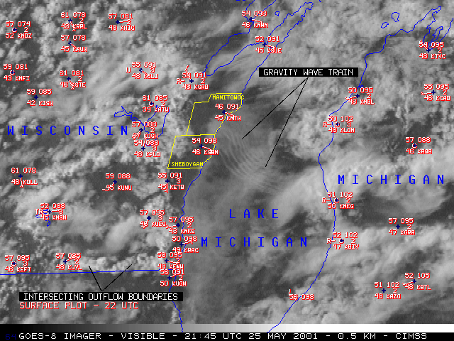 |
An image taken by the GOES imager in the visible wavelength, showing a complex cloud/fog pattern. An outflow boundary initiated a gravity wave train. An outflow boundary is an area of denser air associated with the down draft of some thunderstorms. An outflow boundary really is a low-level small-scale cold front. (Scott Bachmeier) |
The Wisconsin Week Wire for January 15 lists the Wisconsin Weather Stories project among those funded by a grant from the Reilly Baldwin Wisconsin Idea Endowment. The project is a collaboration of SSEC’s Cooperative Institute for Meteorological and Satellite Studies, the Folklore Program at UW–Madison, and the Wisconsin Arts Board, with substantial input from students in the Department of Atmospheric and Oceanic Sciences. The project’s goal is “to develop high-quality teaching tools so that K–12 classes can explore the relationship between verbal art, local culture and weather science.” The Reilly Baldwin endowment is designed to advance the Wisconsin Idea, the “century-old mission to use university resources to improve the lives of people living in the state, the country and around the world.”
Honors
Unidata DeSouza Award—CIMSS’ Thomas Whittaker, meteorologist and software designer, was awarded Unidata’s Russell L. DeSouza Award at the 2003 annual conference of the American Meteorological Society. Whittaker received the award “for playing an instrumental role in molding Unidata’s future through participation in technical working groups, advisory committees, and providing guidance toward the development of community visualization and analysis tools.”
According to the Unidata program office, “Honorees personify Unidata’s ideal of a community that shares data, software, and ideas through computing and networking technologies.” Unidata is a community of education and research institutions with a “common goal of sharing data, tools to access the data, software tools to use and visualize the data, and resources.” It was noted in Wisconsin Week, March 12, that CIMSS and its parent organization, the Space Science and Engineering Center, have collaborated with Unidata by providing expertise, software and data for more than twenty years.
Talbot Prize—Steve Ackerman and John Knox (formerly of UW–Madison’s Department of Atmospheric and Oceanic Sciences) have won the Talbot Prize, which recognizes visual excellence in learning materials. The Society of Academic Authors announced that Steve Ackerman and John Knox were given the award for their textbook, Meteorology: Understanding the Atmosphere. The book was praised by one member of the panel of judges as an “exceptional job pulling together relevant data to be presented in original graphic formats.” The book is published by Brooks/Cole. The prize is named for William Henry Fox Talbot, a photography pioneer, who wrote the important 1844 text, The Pencil of Nature. Talbot’s book is considered the single most important book of photographs ever produced. The Society of Academic Authors, with more than 1,400 members, is the largest authoring organization of its sort.
Passings
CIMSS senior scientist William H. “Bill” Raymond died suddenly of a heart attack at his home on Wednesday, February 5, 2003. Dr. Raymond was a meteorologist with a mathematics background who specialized in numerical modeling and atmospheric dynamics. He made significant contributions in these fields and was an author of more than 40 journal papers, including 14 as sole author. Raymond was 61. He will be sorely missed, professionally and personally, by many at CIMSS and within the scientific community. Bill Raymond’s publications list is available in The Schwerdtfeger Library.
In the Wings
SSEC will host a brown bag luncheon for scientists and graduate students to meet with visiting science writer Glennda Chui on Friday, April 11 at Noon. Staff scientists, faculty and graduate students will have an opportunity to meet informally with Chui, a veteran San Jose Mercury News reporter, one of those receiving the Pulitzer prize for covering the Loma Prieta earthquake. The lunch will take place in SSEC’s 3rd floor conference room (holds 35 people) in the Atmospheric, Oceanic and Space Sciences building at 1225 W. Dayton Street. Terri Gregory is organizing the brownbag luncheon; contact her about attending. Last minute attendees can participate if room allows. Chui will also give a public lecture on Tuesday of that week. University Communications’ Terry Devitt is coordinating Chui’s visit to campus.
Avocations
Michael Dean, a senior instrumentation specialist at SSEC, appeared on the WHA radio show,Higher Ground, on Saturday, January 25, in excerpts from the award-winning play, Mean To Be Free. Dean played the character Joe in this Children’s Theatre production which ran in Madison from February 7 through 22.