Monthly News Summary – January 2003
It’s All About The Ice—
Antarctic Science and Work
by Terri Gregory, SSEC Public Information Coordinator
This issue of In the News covers news and research results primarily from December 2002. Use images freely with credit to the Space Science and Engineering Center, University of Wisconsin–Madison.
SSEC’s Antarctic Meteorological Research Center (AMRC) supplied data and imagery to participants in a NASA field experiment, a collaborative study of Antarctic glaciers between NASA and Chile. Matthew Lazzara and Shelley Knuth provided local area coverage (LAC), specialized satellite data from the NOAA-17 polar-orbiting satellite, to NASA forecasters and pilots flying missions from Punta Arenas, Chile to the Pine Island and Thwaites Glaciers in West Antarctica. The data were especially important because the area is subject to periodic bouts of severe weather. Pilots reported more than one aborted mission due to “forecasts of strong winds and icing conditions at our transit altitude.” The LAC data allowed them to better know what kind of weather they would encounter.
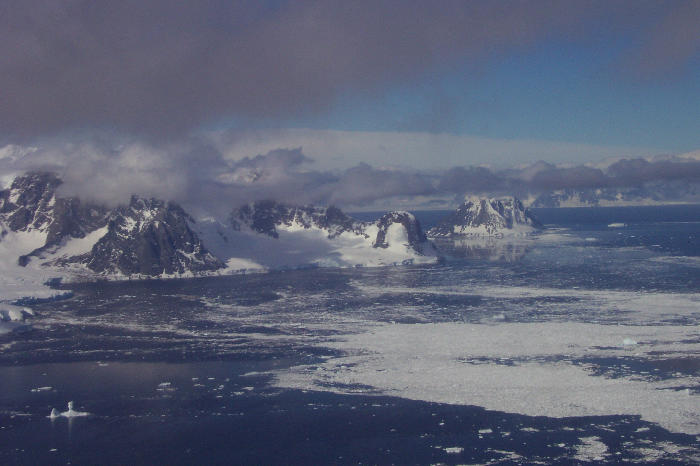 |
The rugged Antarctic shore taken from a NASA research plane flying over |
Live from Antarctica—WORT-FM, public access radio station in Dane County, Wisconsin, will broadcast a live interview with SSEC researcher Matthew Lazzara from McMurdo Station, Antarctica on January 30. WORT’s Dennis Shaffer will interview Lazzara for the station’s science show at 7:30 p.m. Madison time. Lazzara helps to manage SSEC’s Antarctic Meteorological Research Center and is visiting Antarctica for periodic maintenance of the AMRC counterpart in Antarctica and to contact fellow researchers. Lazzara will also carry out his own Ph.D. research on fog, a major Antarctic aviation danger.
Tomorrow—SSEC’s Ice Coring and Drilling Services (ICDS) provided advice and pictures to producers of the motion picture, Tomorrow, to be released summer 2004 by 20th Century Fox and directed by Roland Emmerich (Independence Day). Tony Wendricks, ICDS coordinator, consulted on drilling operations. The movie is described as a science fiction thriller about catastrophic global change. Dennis Quaid stars as a climatologist who supposedly will save the world from global destruction, including an ice-covered New York, where his son is trapped. The first few minutes of the movie may be staged at an Antarctic drilling site in the Antarctic Peninsula. In the real world of Antarctic science, the ICDS is supporting five projects in Antarctica with 14 people altogether. Besides IceCube and AMANDA, they are SPRESO, the South Pole Remote Earth Science Observatory; U.S. ITASE; and international collaborations in Queen Maud Land and at Dome C. The ICDS works with German drillers in Queen Maud Land and Danish drillers at Dome C in eastern Antarctica.
The Antarctic Sun, newspaper for Antarctic research, featured SPRESO on December 29, describing the role of drillers in this science project. According to the Sun, “they drill three of the deepest cored holes ever punched at the South Pole” in perhaps the quietest place on Earth. SPRESO investigates seismic activity; the drilling in the “Quiet Sector” near the South Pole provides a record that can be compared with more seismically active areas. Seismologist Kent Anderson, with the U.S. Geological Survey, explained that, “We can kind of listen to the Earth ringing without the spinning corrupting the signal.” However, recent building activity at the South Pole is disturbing the quiet, so holes now need to be drilled deeper. “At more than 980 feet (300 meters), it will be the deepest ice core ever taken at the South Pole, dating to about 3,000 to 4,000 years old.” Lead ICDS driller Terry Gacke said, “It takes a unique individual to come out here and deal not only with cold weather camping issues, like sleeping in unheated tents at -40, melting snow for our water supply, and cooking our own food, but (also) all the mechanical problems that come using this kind of experimental equipment at these temperatures.”
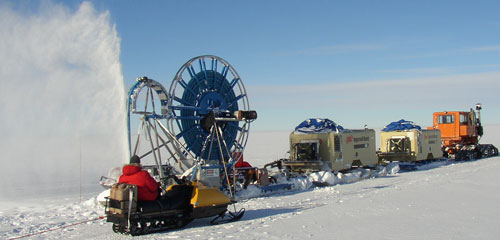
On December 9, Jay Johnson, ICDS Lead Driller for the Shot Hole Project, provided this picture of history being made. He said, “On December 7, we finally found the right set of parameters and proved the shot hole drill is capable of drilling to 75-plus meters!”
University Communications released news of the giant hose reel being fabricated at UW–Madison’s Physical Sciences Laboratory for IceCube; it was featured in campus publicationsWisconsin Week and Wisconsin Week Wire. WISC-TV, Madison, Wisconsin’s Channel 3 (cable 9) featured the hose reel and mentioned IceCube, or Operation IceCube as the news anchor called it, on December 23. Under More Stories, the station’s Web site, Channel 3000, links to SSEC’s IceCube Web site. The Space Daily Web site featured the U.Communications story and the Milwaukee Journal Sentinel used the image on its Web site during the holiday week. SSEC’s Ice Coring and Drilling Services group scoured the world for parts for the behemoth, 23 tons, or 47,000 lbs., reel that will carry hose for a hot-water drill, designed to penetrate 2.5 kilometers into South Polar ice. Senior driller Bruce Koci conceptualized the hot-water drill. The IceCube Web site now includes multimedia presentations.
A thoughtful analysis of one aspect of planetary heating and cooling is “On Thin Ice,” by Robert Bindschadler and Charles Bentley appearing in Scientific American magazine, December 2002. In spite of its dramatic title, the authors restrict themselves to the West Antarctic ice sheet, which covers less than a third of the continent. That ice is vulnerable, and has “disappeared at least once in the past 600,000 years.” The rest of Antarctica (except for the Antarctic Peninsula), called East Antarctica, is more than twice that size and “has been relatively stable for the past 15 million years.” However, if West Antarctica’s ice were to completely melt, it “would raise sea level 5 meters,” enough to cover the bottom third of the Florida peninsula, and presumably Tuvalu and many other South Pacific islands, so scientists understandably are concerned with its future.
Tabular icebergs calve from West Antarctica, from Ronne and Ross Ice Shelves that periodically shed them like skin. The authors carefully explain the dynamics of growth and shrinkage of the ice sheet, fed by immense ice streams, and cautiously predict “that the ice sheet will continue shrinking, but only over thousands of years.”
Bindschadler is now senior research fellow at NASA’s Goddard Space Flight Center. Bentley is emeritus professor in the University of Wisconsin–Madison’s Department of Geology and Geophysics and is principal investigator for SSEC’s Ice Coring and Drilling Services. Each scientist has more than 20 years experience studying and working in Antarctica. Bentley traversed the West Antarctica ice sheet during the 1957–58 International Geophysical Year.
Astronomy
Starry Night—On Christmas Day, the Wisconsin State Journal revisited the Star of Bethlehem story, interviewing Christian pastors, including an historian, and Jim Lattis, director of UW Space Place who also works with SSEC’s Office of Space Science Education. Even scientists do not all agree on whether the Star is a real astronomical event, like a passing comet or star becoming nova. Lattis, a science historian, said that no remarkable events occurred between 8 and 4 BC, the supposed time frame of the birth of Christ. He agreed with those who say the star is “a literary device added to make the birth of Christ even more important.”
Data and Imagery
Physics Today featured the Atmospheric Radiation Measurement Program, or ARM. Authors Thomas Ackerman and Gerald Stokes neatly state the program’s purpose in their first sentence: “To predict reliably what increased greenhouse gases will do to global climate, we have to understand the crucial role of clouds.” Through its Atmospheric Emitted Radiance Interferometer (AERI), SSEC has contributed to the program since its beginning in 1990. An example of AERI measurements and their purpose, to measure the atmosphere’s thermal radiation, is shown in figure 3.
The West Australian newspaper on November 13, 2002 covered an Australian and SSEC contributions to NASA’s earth science program. Their column “Science and Nature” features NASA earth observing satellites Terra and Aqua, especially the MODIS instruments. The Australian connection is SSEC researcher Liam Gumley, responsible for the center’s direct broadcast facility. He presented a workshop in Floreat, Australia on “Practical Applications of MODIS Data in Australia,” an introduction to potential uses of the MODIS data now received at Murdoch University. Gumley graduated from Australia’s Curtin University of Technology and came to the U.S. in 1988.
SSEC cloud information was used in the 2003 calendar, Planet Earth: The View from NASA’s Earth Observing Satellites. SSEC’s and other data are presented in a composite image for December. The data were collected from sensors on different satellites and numerical models and integrated into a single dramatic image of the earth. NASA’s Earth Science Enterprise group at Goddard Space Flight Center produced the beautiful calendar. All 12 months feature satellite images of Earth.
Gregory Carmichael, chemical engineering professor at the University of Iowa, uses Vis5D in a project to forecast pollution as it moves through the atmosphere. The university’s Spectator newsletter for alumni shows Carmichael with an image produced in Vis5D for his project, recently funded by NSF.
Polar Science
Polar Winds—Dave Santek and Chris Velden of CIMSS and Jeff Key, NOAA Team Leader at SSEC, are generating wind measurements over the Arctic and Antarctic in real time from the Moderate Resolution Imaging Spectroradiometer (MODIS) on NASA’s newest Earth Observing satellite, Aqua. They have been producing measurements like these for some time from MODIS on NASA’s Terra satellite, launched in 1998. The quality of Aqua wind measurements is similar to winds produced from the Terra MODIS. Real-time plots are available on the Web. MODIS data are obtained courtesy of Gene Legg and Paul Haggerty in NOAA’s Office of Satellite Data Processing and Distribution.
Jeff Key provided a data set to scientists at Ohio State University’s Byrd Polar Research Center to help show differences in cloud amounts during El Niño and La Niña summers. A. Monaghan and D. Bromwich found significant differences in modeled cloud amounts over Antarctica between the 1997/98 El Niño and the 1998/99 La Niña summers, verifying the model with Key’s extended Polar Pathfinder data set derived from Advanced Very High Resolution Radiometer satellite data.
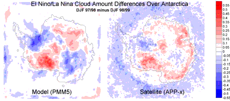
Comparison of modeled and satellite-derived cloud amounts from December through February 1997/98, an El Niño year, and the same months during 1998/99, a La Niña year (1997/98 minus 1998/99), over Antarctica. The image on the left shows cloud amount differences based on the Polar Mesoscale Model 5 (PMM5); the right image shows differences in the extended AVHRR Polar Pathfinder (APP-x) data set.. Click for a larger view.
Tracking Fires
Monitoring Fires—Elaine Prins, who is a NOAA researcher working with SSEC, and Chris Schmidt and Joleen Feltz of CIMSS showed improvement of the newest version of the Wildfire Automated Biomass Burning Algorithm (WF-ABBA) over the previous version. A time series comparison along with other figures were provided for NOAA’s National Environmental Satellite, Data, and Information Service (NESDIS) annual report regarding the operational Hazard Mapping System (HMS). The WF-ABBA uses data from the Geostationary Operational Environmental Satellite (GOES) to track the development of wildfires.
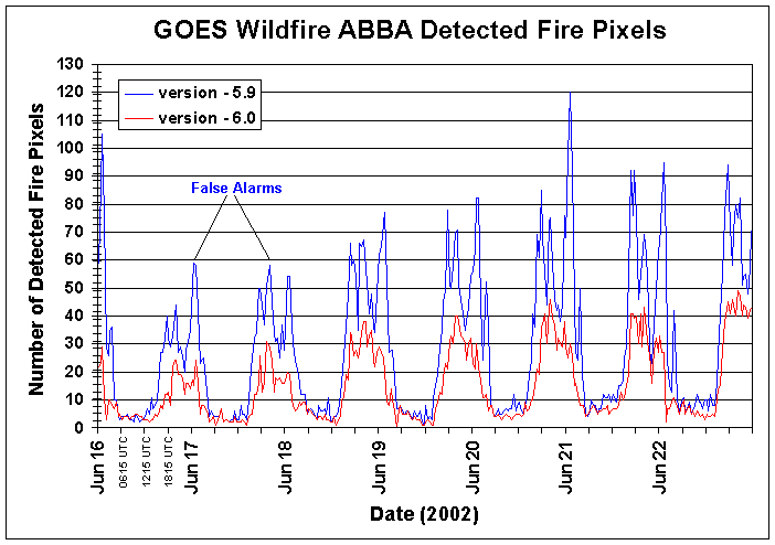
The graph shows how version 6.0 of the GOES WF-ABBA reduced false alarms during one week at the peak of the 2002 fire season (June 16–22, 2002) in North America. The increased fires that the older version of the Wildfire ABBA identified were often false alarms, typically due to reflection off clouds at sunrise and sunset, sun glint from bodies of water, and surface heating during the day.
Aerosol Use—Prins, Schmidt, and Feltz propose to extend their 3-year study focused on assimilating real-time fire products into the Naval Aerosol Analysis and Prediction System(NAAPS) to diagnose and predict aerosol loading and transport in real time. Their proposal, “Analysis of Real-Time Biomass-Burning Transport Model Data with Remote Sensing Products” was submitted to NASA’s Earth Observing System Interdisciplinary Science (EOS/IDS) Earth Science Enterprise’s Modeling and Data Analysis Research program. The Principal Investigator is J. Reid of the Naval Research Laboratory (NRL-Monterey) with D. Westphal (NRL-Monterey) and E. Prins serving as Co-PIs. This proposal includes development and implementation of a global geostationary fire detection system and integration with current and future NASA EOS and international satellite-derived aerosol and trace gas products such as ozone, carbon monoxide, methane, and aerosols.
Modeling Aerosols—At the American Geophysical Union’s fall meeting, T. Eck of NASA’s Goddard Space Flight Center presented results from his work with the CIMSS group who monitor biomass burning using GOES data. Their poster, “Interannual Variability of Biomass Burning Aerosol Optical Depth in Southern Amazonia, and the Impact of These Aerosols on the Diurnal Cycle of Solar Flux Reduction,” showed that, since the early 1990s, measurements of Amazonia’s aerosol optical depth during the dry season display annual variability like that observed with fire pixel counts from the GOES-8 Automated Biomass Burning Algorithm. Eck, Elaine Prins (NOAA) and Joleen Feltz (CIMSS) modeled the effect of aerosols from biomass burning on the solar flux and speculate that the presence of aerosols can result in delays of the onset of cumulus convection (storms), the shortening of the daily period when plants photosynthesize, and reduced time interval for some ultraviolet fluxes which may have implications for photochemical reaction rates, survival of airborne bacteria, insect activity, and plant responses.
Tropical Cyclones
The people on Reunion and Mauritius, islands in the Indian Ocean lying far off the coast of Madagascar, write to tell Tropical Cyclones researchers of their gratitude for imagery when cyclones and other severe weather threatens them. After Cyclone Crystal passed nearby, Shailendra Neewoor wrote Dave Stettner: “…you guys have done a magnificent job covering the cyclone over Mauritius at Christmas time ( So far so good ). Wish there were more people like you to warn this half of the hemisphere. Merry Christmas!”
Tim Olander of CIMSS’ Tropical Cyclones group provided satellite imagery of hurricanes to the art staff of Enterprise, the current Star Trek television program. Late in November, the episode, “Vanishing Point” (episode #210) aired, with actors pointing to stylized hurricanes on a display of the current planet the crew were visiting. Also during the show, Madison, Wisconsin was mentioned as the location of the first test, and failure, of a long-range [100m] human transporter, though the reference may have been an hallucination. An observer noted that, “In Star Trek, most interesting stuff on Earth seems to happen in San Francisco and Montana, so [mentioning Madison] was a change.” It was apparently pure coincidence that the two references appeared on the same show. In Madison, Star Trek: Enterprise runs on UPN, cable 14. Watch the Web page for rerun date.
Weather Experts
For an article on the area’s lack of snow December 30, Brenda Ingersoll of the Wisconsin State Journal interviewed meteorologists with the National Weather Service and SSEC’s Scott Lindstrom, who iterated that there’s no snow in the forecast—not good news for skiers and skaters. [Ed.: This was true until the weekend of January 4 and 5 when it snowed a little.]
Weather Research
CIMSS Highlights—The Board of Directors of SSEC’s Cooperative Institute for Meteorological Satellite Studies held its annual meeting on Wednesday, December 4. Board members come from NOAA’s National Environmental Satellite, Data, and Information Service (NESDIS); NASA; and the University of Wisconsin–Madison’s Graduate School, Department of Atmospheric and Oceanic Sciences, and SSEC, and CIMSS. Steven Ackerman, CIMSS Director, Thomas Achtor, SSEC Executive Director for Science, and others presented 2002 highlights. Research advances included deriving wind measurements from MODIS data, collaborations with the National Weather Service and with international agencies, studies of effects of satellite data on numerical models, many applications of GOES data, Geostationary Imaging Fourier Transform Spectrometer developments, advances with the Atmospheric Emitted Radiance Interferometer and with the Scanning-High resolution Interferometer Sounder, cloud climatology, and many others. The PowerPoint presentation is available on the CIMSS home page (left frame). You must have PowerPoint on your machine to view it. Email the CIMSS Webmaster or SSEC’s Webmaster for details on any project or other item.
Pan-American Satellite Conference—SSEC researchers participated in the Satellite Direct Readout Users Conference for the Americas in December in Florida. The Conference, sponsored by NOAA, the National Oceanic and Atmospheric Administration, drew remote sensing specialists from both North and South America. Presentations were made by and to users of the NOAA geostationary and polar orbiting satellites, potential users of the forthcoming METOP polar orbiting satellite comprising part of the Initial Joint Polar-Orbiting Operational Satellite System, and the future NOAA NPOESS. Most aspects of the U.S. satellite program were covered, future and current, including SSEC and CIMSS research applications.
Paper—Mat Gunshor, CIMSS, and Tim Schmit and Paul Menzel, NOAA, submitted “Intercalibration of the infrared window and water vapor channels on operational geostationary environmental satellites using a single polar orbiting satellite” to the Journal of Atmospheric and Oceanic Technology. The paper outlines the results and methodology that CIMSS uses to compare geostationary instruments with instruments on polar-orbiting satellites, especially the High-resolution Infrared Radiation Sounder (HIRS) and Advanced Very High Resolution Radiometer (AVHRR).
Education, Outreach
The Baldwin Wisconsin Idea Endowment has funded Wisconsin Weather Stories, “to make the name of Vern Suomi as well known as Babcock.” According to Steven Ackerman, that’s the ultimate goal of an outreach grant that will teach students how to tell a good weather story, with meaningful scientific interpretation. In this one-year statewide program, three partners, the Cooperative Institute for Meteorological and Satellite Studies (CIMSS), the Folklore Program at UW–Madison and the Wisconsin Arts Board will create a K–12 curriculum guide on stories, sayings, science, and significance of Wisconsin weather. Steven Ackerman, Anne Pryor and Jim Leary will make this guide available free of charge on three Web sites—CIMSS, Folklore and Arts Board—enabling Wisconsin teachers to expand their earth science, social studies and language arts curricula in engaging and locally relevant ways. This spring semester, the investigators will recruit teachers throughout the state and students in both folklore and meteorology departments who will collect stories about their local weather—like the Peshtigo fire, Great Lakes storms, the Barneveld and Siren tornadoes—and relate the stories to the science behind the weather event. In the summer of 2003, teachers will come to Madison and learn how to interview people and collect and interpret weather observations. SSEC’s CIMSS will assist teachers and their classes in these processes. Steven Ackerman directs CIMSS and is a professor in the Department of Atmospheric and Oceanic Sciences, James Leary directs UW–Madison’s Folklore Program and is codirector of the Center for the Study of Upper Midwestern Cultures and Professor of Scandinavian Studies, Anne Pryor is Folk Arts Education Specialist at the Wisconsin Arts Board.
Avocations
Creative Comics—Madison’s weekly news and entertainment newspaper, Isthmus, features a trio of creative minds who are bringing the Japanese art form, anime, online. Ray Garcia, SSEC software programmer, applies 3-D modeling and lighting to the artistic efforts of Maciek and Kim Smuga-Otto. Their online graphic novel is called Death and Transfiguration, based in a future society where brains can be transferred into different bodies. If you get hooked on the series, be warned—Each chapter takes about a month to conceive, draw and implement online. They’re worth the wait.