Monthly News Summary – October 2002
Monitoring Phosphorus Loss
by Terri Gregory, SSEC Public Information Coordinator
This month’s column includes news coverage mostly from September, current research and future events. Use images freely with credit to the Space Science and Engineering Center, University of Wisconsin–Madison.
UW–Madison researchers will study how phosphorus, mostly in manure, is lost from farm fields to waterways. The three year grant from the U.S. Department of Agriculture will enable researchers from Soil Science, Biological Systems Engineering, Space Science and Engineering Center, and Agricultural and Applied Economics to measure phosphorus moving from fields to surface waters, where it promotes harmful algae blooms and endangers the lives of fishes and other stream inhabitants. Phosphorus is also believed to contribute to the Dead Zone in the Gulf of Mexico.
John Norman of Soil Science in the university’s College of Agricultural and Life Sciences leads the research to study a watershed in Buffalo County, WI. This area contains headwaters of two streams leading to Traverse Valley Creek, a Class 1 trout stream. The area also includes a Discovery Farm, which will participate in the study. The State of Wisconsin set up the Discovery Farm program as an independent network of operating, commercial Wisconsin farms to engage in research and demonstration projects.
Key to quantifying results from the phosphorus study is a model developed by SSEC’s Christine Molling and George Diak and John Norman called the Precision Agricultural-Landscape Modeling System. Faculty from Cooperative Extension will help ensure that PALMS can be used to assess phosphorus loss from several commercial farm fields used to validate the model. The PALMS Model is designed to be used easily by agricultural consultants who work with farmers. Eventually, researchers hope to use PALMS to combine productivity, profitability and environmental issues and strengthen relationships between Cooperative Extension, agricultural consultants, state regulatory agencies and the agricultural research community.
Antarctica
AMRC tenth anniversary—SSEC’s Antarctic Meteorological Research Center is ten years old this October 30. Matthew Lazzara, who manages the AMRC, says that the first composite of Antarctica was made from satellite imagery that day in 1992 at 6:00 UTC. Today, many more satellites are used in the composite and the continent is covered more often.
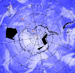 |
SSEC’s AMRC created this image of Antarctica from infrared imagery from several weather satellites, primarily polar orbiting. The image was produced on October 2, 2002. Blocks of black space indicate missing imagery or a lack of satellite coverage. |
Chuck Stearns, principal investigator of the AWS and AMRC projects, provided background for a film on Robert F. Scott’s tragic journey to the South Pole. October Films, London, borrowed a tape, “Working in Antarctica,” produced by NSF that contains footage of the Automatic Weather Station program. The film will be shown in January on Channel Four in England and on PBS in the U.S. as “Tragedy at the Pole.”
Ian Frazier’s article on Arctic and Antarctic icebergs appears in Outside magazine’s 25th anniversary issue, October 2002. Frazier interviewed SSEC staff in UW–Madison’s AWS and AMRC projects for background on Antarctica. The feature article stresses human interest and confuses the presence of icebergs with global warming.
The January issue of National Geographic Kids will include an article about emperor penguins with background on Ross Sea icebergs. SSEC’s AMRC has monitored the icebergs since B-15 calved in March 2000. Information from the Iceberg FAQ was used.To access the FAQ, click on Frequently Asked Questions (FAQ) on the icebergspage.
Data and Imagery
McIDAS users meet—The annual McIDAS Users Group Meeting is scheduled for October 9–10 at Union South in Madison. Users of SSEC’s McIDAS (Man computer Interactive Data Access System) will arrive from around the world to share information and concerns. Some users will speak briefly about their site and the work they are doing with McIDAS, which is used for weather forecasting and research and imagery analysis of all sorts. Among those attending are Fred Mosher, with the National Weather Service’s Aviation Weather Center in Kansas City; Louis Nguyen of NASA’s Langley Research Center; Brian Hughes of Satellite Operations in NOAA’s World Weather Building near Washington, D.C.; James Kelly of Australia’s Bureau of Meteorology Research Centre; and Marianne König of Eumetsat in Germany.
David Kuck, teacher in Sheboygan, Wisconsin’s Urban Middle School, uses the global montage and the movies based on them to demonstrate how temperatures change around the world. Kuck doesn’t have a Web site; he shows the images on a screen with an LCD projector and says they “are of tremendous help.” For example, “watching the cloud patterns over the Andes indicates the wet and dry side of mountains while also indicating what zone the clouds are in.” Kuck said that he uses the images from the CIMSS “Tropical Cyclones page to indicate to students where hurricanes start forming.” Besides using the imagery in class, he also shares it with parents who have Internet access, so they’re always tuned into his earth science classes.
Craig Dremann is an ecologist using the SSEC global montage as the opener on his browser. He recommends it in his article appearing in Brazil’s The Ecologist magazine for fall 2002. The article is written in Portuguese. Note that the image Dremann used sometimes experiences problems, and a better page to publish may be the Compositespage, with a wealth of different satellite composite imagery.
DLESE—The Digital Library for Earth System Education has included SSEC’s Images and Data Web page in the library’s Broad Collection. The library, a collection of resources for earth system teachers, is divided into Broad and Reviewed collections. Any member of the “DLESE Community” can nominate a Web site or other educational resource for the broad collection, while items in the reviewed collection must meet certain criteria, including scientific accuracy, pedagogical effectiveness, and ease of use. SSEC has been invited to submit our Web page for review, and we have done that. If it passes review, it will be included in the DLESE Discovery System.
MODIS Served—Thanks to SSEC’s Direct Broadcast facility, UW–Madison’s Environmental Remote Sensing Center (ERSC) is serving daily MODIS images of Wisconsin. ERSC director Thomas Lillesand announced October 3 that their MODIS Web site was up and running. “ERSC is in the same building as SSEC, so it was natural for us to think to serve the data to the people of Wisconsin,” Lillesand said. ERSC’s MODIS Server developers acknowledge the help of Liam Gumley, broadcast facility manager. ERSC enhances the images to focus on land features, not clouds.
AniS—CNN Headline News used a Java applet developed at SSEC to show the progress of Tropical Storm Isidore on September 25. The applet, called AniS, is developed by SSEC’s Tom Whittaker to animate images and is based in the work done for VISIT, a National Weather Service training program for weather forecasters. AniS and other SSEC software is available on the Web.
An image from the WIYN telescope was featured in Wisconsin Research: Profiles in Discovery, published in September by University Communications for UW–Madison’s Graduate School. SSEC designed and fabricated the control system for the telescope, built and run by a consortium of universities (Wisconsin, Indiana, Yale) and the National Optical Astronomical Observatories. The image shows a galaxy in the constellation Cygnus.
Neutrino News
Neutrino 2002 report—“IceCube—the next generation neutrino telescope at the South Pole” was presented at the 20th International Conference on Neutrino Physics and Astrophysics held May 25–30, 2002 in Munich, Germany. Professor Albrecht Karle, of UW–Madison’s Department of Physics, submitted the report on behalf of the many members of the IceCube collaboration, scientists from around the world. Karle stated that recent progress in simulations is based primarily on Henrike Wissing’s work at DESY in Zeuthen, Germany. He notes that improved analysis methods were used to obtain quantitative results on the sensitivity of IceCube at energies above one PeV (one million times a billion electron Volts) for particles entering the telescope from above. “Neutrinos are the only subatomic particles able to transit the entire earth to enter the detector from below, whereas millions of cosmic ray particles enter from above, enabling us to calibrate the detector,” explained project scientist Robert Morse. This increased sensitivity is a big step forward, because it shows that IceCube can operate efficiently at high energies as an all-sky neutrino telescope. Science institutions around the world are involved in AMANDA, the Antarctic Muon and Neutrino Detector Array, the first neutrino telescope to be based in polar ice, and IceCube, its much larger extension. The complete list of participating institutions is available on the Web and in the report.
Exploratorium features AMANDA—San Francisco’s premier science museum features AMANDA on its Origins Web site. The site presents interactive activities and essays on AMANDA, including an essay by Francis Halzen, AMANDA scientist and principal investigator for IceCube.
Tracking Fires
Monitoring fires in Southeast Asia—The National Weather Service’s International Activities Office has asked the SSEC group monitoring fires with geostationary weather satellites to propose adapting their technique to work with a GOES satellite to be positioned over Asia. Up to now, the Wildfire Automated Biomass Burning Algorithm (WF-ABBA) has been used with GOES-8 and -10 satellites. The GOES-9 instrument will be placed over the equator at 155° E. The proposal supports the Program to Address ASEAN (Association of South East Asia Nations) Regional Transboundary Smoke (PARTS). The primary user of the fire product will be the ASEAN Specialized Meteorological Center (ASMC) in Singapore. The Wildfire ABBA will provide an overview of the diurnal fire cycle and will augment current fire products produced from NOAA and U.S. Air Force polar orbiting weather satellites. This activity will also be used to prepare for future geostationary fire detection throughout the region with the launch of the Japanese Multi-functional Transport SATellite in 2003.
Western wildfires—The CIMSS/NOAA wildfire detection technique (WF-ABBA) is featured in On Wisconsin magazine, fall 2002. The article notes that the technique went “online in the midst of one of the country’s worst fire seasons.” It had been tested for years and new technology made operational use possible this year. In the last sentence, editors mistakenly attributed a variety of applications to the team who monitors fires. In reality, the entire Cooperative Institute for Meteorological Satellite Studies develops a variety of applications for the GOES and other satellites.
Tropical Cyclones
 |
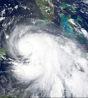
This MODIS image shows Hurricane Lili in the Gulf of Mexico on October 2 at 1640 UTC. Its exact location is 25.3S 89.4W. The 250 m resolution image was received at SSEC’s Direct Broadcast Facility. |
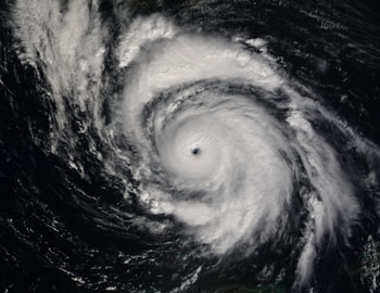
Hurricane Research—On September 25, University Communications’ Emily Carlson released SSEC imagery showing Hurricane Isidore approaching landfall on the U.S. Gulf of Mexico coast. She noted that the CIMSS Tropical Cyclones group monitors hurricanes throughout the season and that the techniques it develops are used by the U.S. Navy, the National Hurricane Center and other agencies to continually update their ability to track hurricanes. CIMSS researcher Tim Olander talked with WIBA news director Josh Wescott about CIMSS’ long history (since 1980) of tropical cyclone research. His interview appeared on WIBA 1310-AM throughout Thursday afternoon. The Badger Herald, a UW–Madison student newspaper, featured the hurricane research on September 30.
 |
This image of Tropical Storm Isidore was received by SSEC’s Direct Broadcast Facility on September 20. It appeared on NASA’s Earth Observatory Web page and on the home page of the Goddard Space Flight Center’s Web site on September 23. Isidore changed from Tropical Storm to Hurricane and back as it hit landfall in Louisiana and Alabama, dumping inches of rain along the way. |
In an August 18 article on the tenth anniversary of Hurricane Andrew, the Milwaukee Journal Sentinel featured an image produced by the CIMSS Tropical Cyclones group. It was attributed to the Associated Press.
Weather Experts
Weather Guys Steve Ackerman (CIMSS director and AOS) and Jonathan Martin (AOS) appeared again on Larry Meiller’s Monday morning WHA Radio call-in show. On September 30, they answered questions about climate, local weather and the impending winter. Ackerman said that this El Niño will not have as strong an influence on this Wisconsin’s winter as did the last El Niño; he expects us to have almost as much snow as normal, at least enough for cross-country skiing. His remarks were caught by WPR’s Melva Lara for the Wisconsin segment of All Things Considered. The Weather Guys generally appear on WHA the last Monday of every month from 11:45 to 12:30. In south and central Wisconsin, you can listen at 970 AM and 90.7 FM, or listen from anywhere on the Web.
El Niño information—SSEC scientist David Martin provided information on the impending El Niño for the German magazine Max. He agreed with groups like the U.S. Climate Prediction Center that an El Niño has begun. He noted that, thus far, it seems to be one of the weaker ones.
New book—Steve Ackerman’s book, “Meteorology – Understanding the Atmosphere,” was mentioned in Wisconsin Week and Wisconsin Week Wire (September 18). Ackerman co-authored the book, published by Brooks/Cole-Thomson, with John Knox, professor and scientist at the University of Georgia.
Weather Research
How high the cloud?—When GOES-12, NOAA’s newest and most advanced geostationary weather satellite, comes into routine use, it will be possible to more accurately measure the height of volcanic dust clouds. These clouds of dust, ash and gas can extend as high as 40,000 feet (12 km), as high as jetliners fly, but previous satellites could not accurately measure that directly. The channel used on the satellite imaging instrument was at 11 microns, in the infrared, or a “window” channel, making it necessary to make statistical assumptions about the cloud. Sometimes this led to a false reading; the cloud was thought to be warmer and lower in the atmosphere than it was. The imaging instrument on GOES-12 has a channel that allows the effects of carbon dioxide to be measured directly, making it possible to infer the height of the volcanic dust cloud. SSEC has developed a technique, called CO2 Slicing, that enables measurements to be directly used for determining the height of a cloud.
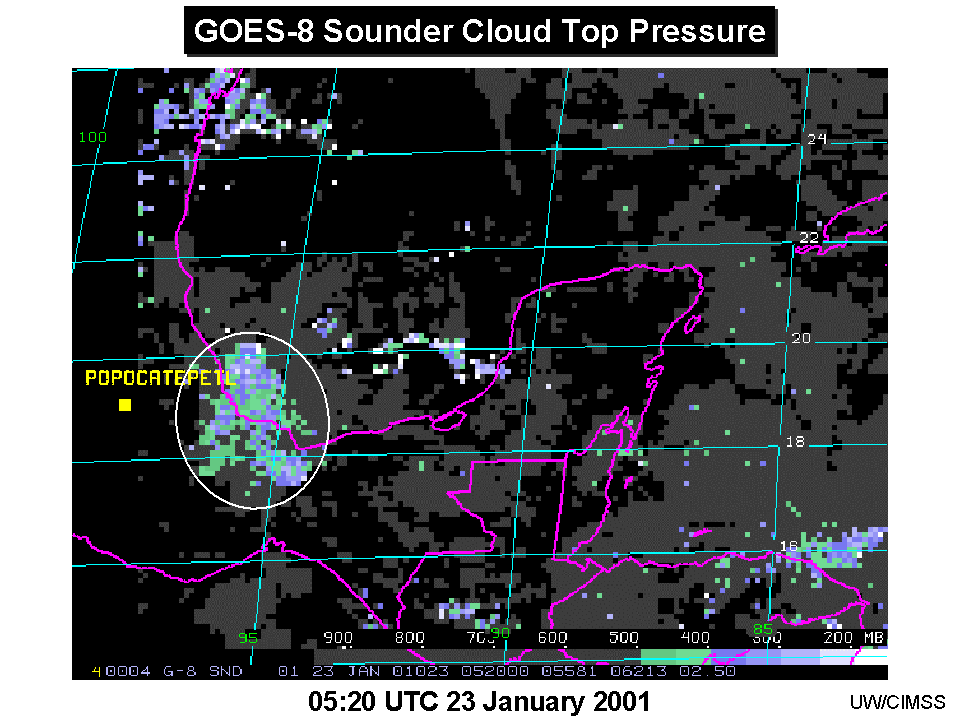 |
Click on this image for a larger version of cloud-top height measurements. White is highest in the atmosphere, green lowest. |
Tony Schreiner (of SSEC’s CIMSS) applied that technique to the Popocatepetl volcano (19.01° N and 98.37° W) in Mexico. For the eruption on January 23, 2001, Schreiner based cloud-height measurements on radiance measurements from the GOES-8 Sounder (the GOES-12 Imager was not operational at the time). Using reports from the Volcanic Ash Advisory Center (VAAC) in Washington, D.C. describing the location of the Popocatepetl volcano dust cloud, Schreiner tracked the height for eight time periods on January 23. With researchers Tim Schmit (NOAA, at SSEC) and Gary Ellrod (NOAA), he found the top of the cloud to be between 400 and 200 hPa (roughly 25,000 to 40,000 feet). The VAAC height estimate was about 200 hPa (about 40,000 feet).
Using AIRS data—Now that the high vertical resolution data of the Atmospheric InfraRed Sounder (AIRS) instrument is available to researchers, they are using it to simulate instruments that are being developed. AIRS was launched this spring on NASA’s Aqua satellite, the latest in the Earth Observing System. CIMSS researchers Fengying Sun and Mat Gunshor are using AIRS data to simulate spectral coverage of the future Hyperspectral Environmental Sounder (HES). Animations of the AIRS bands can be seen on the CIMSS Web page.
The habits of clouds—It is now possible to simulate the effects of ice cloud particle shapes and sizes on satellite observations, as shown in “Parameterization of short-wave ice cloud optical properties for various particle habits,” to be published in the Journal of Geophysical Research-Atmospheres. Authors are J. Key (NOAA team leader at SSEC), P. Yang (Texas A&M University), B. Baum (NASA’s Langley Research Center, stationed at SSEC), and S. Nasiri (SSEC’s CIMSS). The authors present in a new way the short-wave optical properties of various ice particle “habits” including hollow and solid columns, aggregates, plates, bullet rosettes, and dendrites.
Education, Outreach
WSGC status—According to a University Communications News Brief published September 16, NASA has announced designated status for the Wisconsin Space Grant Consortium. “Designated” status confers additional budget and program responsibilities. The Green Bay-based group will have its budget roughly doubled. Member colleges and universities, including UW–Madison, benefit through research grants to students and faculty. Tom Achtor, SSEC’s Executive Director for Science and WSGC’s Associate Director for Research stated that research support would increase by two to three times. Sanjay Limaye, UW–Madison institutional representative to the WSGC, cautioned that funds have not yet been received in Wisconsin and that nothing much will change until NASA’s budget is approved. The award was also noted inWisconsin Week Wire for September 18 and Wisconsin Week.
In the Wings
Elaine Prins gives the public lecture at Space Place, 1605 South Park Street on October 8. Prins directs the CIMSS group who develops computer techniques that use the GOES satellite to monitor fires from space. She will present the group’s research along with many examples.
According to University Communications’ News Briefs for September 12, Francis Halzen will give the campus Roundtable lunch talk on October 16. Physics professor Halzen is principal investigator for the IceCube project and will discuss “Ice Fishing for Neutrinos at the South Pole.”