Monthly News Summary – January 2002
Hudson Bay Freezes, We Watch
by Terri Gregory, SSEC Public Information Coordinator
January 2002
This issue of In the News covers December 2001 and includes news not covered in previous issues. Use images freely with credit to the Space Science and Engineering Center, University of Wisconsin–Madison. We’d appreciate a copy or notice when you use something.
Canada’s Hudson Bay freezes every year around this time. This year, the MODIS instrument on board NASA’s Terra earth science satellite enables us to watch the process. Scott Bachmeier of SSEC’s Cooperative Institute for Meteorological Satellite Studies (CIMSS), who maintains the GOES Gallery on the CIMSS Web site, has animated images received through SSEC’s rooftop antenna. Bachmeier warns that the images are large: Your monitor should be set at 1024×768 or higher. The image loop will keep accumulating daily images until Hudson Bay is completely frozen.
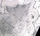 |
Hudson Bay as it starts to freeze. Click on the small image for the animation. After watching the loop and finding the cloudy days, you can eliminate them by clicking on those green squares found to be cloudy, and, as Bachmeier states, “just watch the ice creep southward.” |
Broadcast
For more information
Weather records—Wisconsin’s unseasonably warm weather made local and regional news. Comparing data recorded at Madison’s local airport, Truax Field, SSEC’s Scott Lindstrom found that November 2001 was the warmest on record here. The mean temperature of 46.0° F was more than 10 degrees above normal. University Communications released the findings as a news tip and Lindstrom was interviewed for Madison’s WISC-TV Channel 3 on a balmy Sunday afternoon with roses blooming in the background. The piece aired Sunday night, December 16. WIBA radio’s Josh Wescott interviewed Lindstrom and he was quoted in Madison’sCapital Times newspaper (December 18). Madison’s temperature rose to 64° F on December 5, the warmest recorded Madison temperature on that day. On December 26, winter finally arrived in Madison—the high was 18° F.
Anniversary—Steve Ackerman (CIMSS director and UW–Madison Department of Atmospheric and Oceanic Sciences) and John Knox (University of Georgia, Department of Atmospheric Sciences) were interviewed on WCCO-AM, a Minnesota radio station, early Saturday morning on the anniversary of the sinking of the ore ship Edmund Fitzgerald. The ship sank on November 10 in 1975 in the worst shipping disaster on the Great Lakes in the preceding 11 years. Ackerman and Knox explained the dreadful weather conditions and their effect on the ship.
Weather Guys Steve Ackerman and Jonathan Martin, UW–Madison Department of Atmospheric and Oceanic Sciences, appeared Monday, December 31 on Larry Meiller’s WHA Radio call-in show. Jon Martin explained the long period of warm weather in Wisconsin as a “persistent southwesterly flow.” It made this December, even with the last week of seasonably cold temperatures, 9 or 10 degrees above normal. They talked about reviewing data for trends. Steve Ackerman fielded questions on optical phenomena—rings (coronas) around the moon, why the sky is blue (the cleaner the air, the bluer the sky). Martin, who wouldn’t mind living in Buffalo, NY, explained why so much snow fell on that city at one time—Extreme lake effect snow is enhanced by persistent upper level processes. The Weather Guys appear next on January 28. WHA Radio is at 970 AM and on the Internet. Click on Live Ideas Network Webcast.
Japanese television viewers soon will see satellite imagery and analyses produced by the CIMSS Tropical Cyclones group. WeatherNews Inc., with offices around the world, will use them in Chiba City, close to Tokyo, Japan. Meteorologist Masako Konishi said that their station referred to the Web site images during cyclone season and “found them very useful.” Now they’d like to use the images on the air with credit to CIMSS. Japan’s WeatherNews television station has 2.4 million viewers.
Composite imagery—The December 9 episode of the ABC drama series Alias used SSEC composite images. The espionage program showed CIA agents in a control room monitoring various data sources on banks of monitors. SSEC’s browse-quality imagery is freely available on the Internet. If you see SSEC imagery used in unusual ways and places, email us using our web form.
Weather Research
ABI—CIMSS and NOAA scientists stationed at UW–Madison continue to provide input for the next generation of instruments for the U.S. Geostationary Operational Environmental Satellite (GOES). Tim Schmit and Elaine Prins (NOAA) propose a 15-band option for the Advanced Baseline Imager (ABI) consisting of the original 12 bands and three new bands centered at 0.47, 7.4, and 9.7 microns to better detect aerosols, moisture flow, sulfur dioxide, and total ozone and for multi-band color products,. An 18-band configuration would consist of the 15-band option plus bands at 2.1 and 3.7 microns for hot spot (fire) detection and cloud information, and a 0.55 micron band for a true green in color composites. Reserchers also supplied information regarding fire channel needs, including an evaluation of 3.9 micron maximum brightness temperature and noise requirements at both 1 and 2-km spatial resolutions.
GOES-12 Test—During the recent science test of GOES-12, launched in July, the CIMSS cloud top pressure product was compared to that from other GOES instruments. In general, Tony Schreiner (CIMSS) and Tim Schmit (NOAA) found fair agreement among cloud top pressure products from the GOES-12 Imager, the GOES-12 Sounder, and the GOES-8 Sounder. Slight differences are due to different view angles, noise, time differences, and the lack of a 12 micron channel on the GOES-12 Imager that aids in low-cloud detection. The GOES Imager provides a finer spatial resolution product.
Fires 2001—Elaine Prins (NOAA) and Joleen Feltz and Chris Schmidt (CIMSS), who monitor biomass burning with the GOES satellite, have released statistical results for the 2001 fire season in South America. Fire products made with their Automated Biomass Burning Algorithm (ABBA) for June through October 2001 indicate that the amount of burning was greater than in the 2000 fire season, but nearly 12% less than that observed on average over the past seven years. In 2001 nearly 300,000 fire pixels were detected with the GOES-8 ABBA at 11:45, 14:45, 17:45, and 20:45 UTC. These results are being used to characterize diurnal (daily), spatial, seasonal and interannual trends in fire activity throughout South America. The study area extends from 0 to 40°S and from 35 to 75°W and includes portions of Brazil, Peru, Bolivia, Paraguay, Uruguay, and northern Argentina.
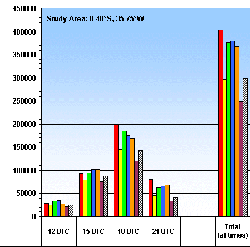 |
The GOES ABBA and Merged Automated Cloud/Aerosol Detection Algorithm (MACADA) were applied to multispectral data collected every 3 hours from June through October in each year from 1995 to 2001. Click on the image for a larger figure, which gives an overview of the number of fire pixels detected at each time period and shows total burning for each year, along with the percent of opaque cloud coverage. The number of fires detected in the 2001 fire season was 26% less than observed in 1995, but is greater than in the year 2000. The opaque cloud coverage shows whether the interannual variability in the number of detected fire pixels is due to cloud coverage issues. |
GWINDEX—CIMSS and the National Environmental Satellite, Data, and Information Service (NESDIS) are preparing for another GOES rapid-scan WINds EXperiment (GWINDEX) to take place during the next Pacific Jet (PACJET) west coast field campaign this winter (January – March, 2002). Chris Velden and Dave Stettner of CIMSS with J. Daniels of NESDIS will produce GOES-10 winds from rapid-scan imagery every 3 hours and will disseminate them to the National Weather Service western region forecast offices and the Forecast Systems Laboratory for Rapid Update Cycle (RUC) model assimilation.
In Print
What do you use to illustrate weather around the world in color? SSEC’s global montage, known in house as the color mollweide, for the map projection used. Two periodicals have printed the image-UW-Madison’s alumni magazine, On Wisconsin (Winter 2001) and Discover magazine (December 2001). In Discover, the montage illustrates an article on a study by the National Center for Atmospheric Research (Colorado). Scientists looked at how much of the earth’s heat is carried through its atmosphere and how much through the ocean. Incidentally, SSEC was founded on studies of Earth’s heat budget and has collaborated other years with NCAR on this and other atmospheric research issues.
An image credited to CIMSS and NOAA’s Hurricane Research Center (HRD) is used on the cover of the December 2001 Bulletin of the American Meteorological Society for the cover story on the accuracy of forecasting Atlantic Ocean hurricanes from 1976 through 2000. The HRD’s Jason Dunion (formerly with CIMSS) collaborated with SSEC’s Rick Kohrs to produce the image.
In La Météorologie for May 2001, Verner Suomi’s role as father of satellites, “père des satellites météorologiques,” is noted in an article on Meteosat. He is given credit for his spin-scan camera invention, which made it possible to track the earth’s weather from space. La Météorologie is the journal of France’s meteorological society.
On the Net
Virtual Museum—The latest addition to the Verner Suomi Virtual Museum is a video clip, taped in about 1994, in which Professor Suomi explains geostationary and low earth orbits and their usefulness in studying the weather. The online museum is being developed as a tribute to SSEC’s founder, the father of weather satellites. The museum encourages its visitors to learn about satellite meteorology through interactive modules and other teaching aids. To find the movie, go to the bottom of the page.
The Islands of Corsica, France, and Sardinia, Italy, are showcased in NASA’s Earth Observatory. Liam Gumley provided the nearly clear image on December 10, received by SSEC from the MODIS instrument on NASA’s Terra satellite.
SciTechResources—The U.S. Department of Commerce’s National Technical Information Service lists the Antarctic Meteorological Research Center in a new Web site. SciTechResources.gov catalogs “government science and technology resources.” The site is looking for new links and aims to be as comprehensive as possible. SSEC’s AMRC is funded by the National Science Foundation but is part of SSEC, a unit in the UW–Madison’s Graduate School.
Browser—Fritz Kruse of the Dodge City National Weather Service says, “You guys have outdone yourselves with the Geostationary Satellite Image Browser…very cool!!!!” Kruse, a UW–Madison alumnus, adds that “the enhancements are great!! Especially I like the EC curve on the IR.” The image browser is a new addition to the SSEC Web site. New features continue to be added.
Jennifer Fimbres uses a CIMSS image in her Web page on the Super Storm Outbreak of 1974. Fimbres, a geology student at the University of Arizona, states that this was the largest tornado outbreak in recent history. The GOES Gallery provided the image to show tornadoes forming in May 1999.
Outreach
The Wisconsin Alumni Association is sponsoring a tour of Arizona’s astronomical and other highlights. Jim Lattis, UW Space Place director, and Sanjay Limaye, SSEC scientist who directs its Office of Space Science Education, will guide the tour. The tour will be held in April, when Arizona is sunny and warm, and will include star parties and visits to astronomical sites like the WIYN telescope on Kitt Peak. In one week, the group will visit space-related laboratories at the University of Arizona in Tucson, the Arizona-Sonora Desert Museum, Oak Creek and Grand Canyons, Sunset Crater National Museum and other star-studded spots. Members of this small group tour will benefit from expert guidance and have a rousing good time. For more information, contact the Alumni Association at 888-922-87282 and ask about “Cacti to Craters.”
Sanjay Limaye gave one of two keynote speeches on Earth Reesrch Day held on November 16 at the Lac Courte Oreilles Ojibwa Community College in northern Wisconsin. On a day devoted to exploring environmental science and educational issues, Limaye spoke on “Global Warming-Fact or Fiction” and a “Space Science Curriculum.”
Project Kaleidoscope (PKAL) asked CIMSS Director Steve Ackerman to give the keynote speech at its National Assembly held in Madison in October. Appropriate to the meeting’s theme, “Science at the Cutting Edge: Bringing Advances in Science and Technology into the Undergraduate SME&T Environment,” spoke on the difficult task of integrating research with teaching. Ackerman combines teaching in UW–Madison’s Department of Atmospheric and Oceanic Sciences with his research in the Cooperative Institute for Meteorological Satellite Studies. He told the assembled professors not only of effectively bringing technology into his Meteorology 101 classes, at a much earlier level than usually attempted, but of prominently including student contributions into research projects. He focused on the CIRRUS project, which NASA had funded as a feasibility study. CIRRUS, the Cloud Infrared Radiometer for University-class Earth System Science (UnESS), would study ice clouds from the International Space Station. Students were involved in every activity, from designing and building the instrument to designing the project’s logo.
In his PKAL talk Ackerman noted the delicate balance for him as a teacher and scientist, meshing both these roles and others. PKAL teachers work “to build strong learning environments for undergraduate students in mathematics, engineering and the various fields of science.” Ackerman’s CIRRUS project has not yet been funded as a full-scale project because UnESS was dropped from the NASA budget solely because of cost-cutting measures.
Honors
Capt. Kurt Brueske’s work on AMSU has been nominated for the U.S. Air Force’s von Karman award, given for outstanding contributions to national defense in the field of science and engineering. Brueske, a recent Ph.D. recipient from UW–Madison’s Department of Atmospheric and Oceanic Science, performed his research as a member of the CIMSS Tropical Cyclones group and gives credit to the group for their contributions.
In the Wings
The Discovery Channel will air a program on Hurricane Floyd starting in January. CIMSS’ Tropical Cyclones group provided imagery. Network times are given; check your local listings for times in your area:
January 23, 9:00 p.m. and again at 1:00 a.m.
January 26, 1:00 p.m.
March 4, 10:00 p.m. and 2:00 a.m.