SSEC group helps fill in gaps on remote wind measurements
For decades, weather satellites have provided the instruments of choice for monitoring atmospheric wind speed, movement and direction, especially in places less accessible by other modes of measurement. Until recently, though, researchers still grappled with incomplete and inconsistent imagery. A team led by Matthew Lazzara at the University of Wisconsin’s Space Science and Engineering Center (SSEC) has turned a new page on generating high-quality wind imagery, with a technique that promises improvements for forecasting and numerical weather prediction.
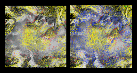
A team at the University of Wisconsin has generated high-quality Atmospheric Motion Vectors from LEO/GEO composite satellite images (shown at right, compared with the more visible “gap” in coverage at left). These could improve numerical weather prediction. Photo credit: Matthew Lazzara
Scientists typically track patterns of atmospheric motion—wind, essentially—swirling and unfolding over a large area by inspecting many successive sets of satellite images called Atmospheric Motion Vectors, or AMVs. They have been able to generate and use AMVs from geostationary (GEO) satellite observations over mid-latitudes and the tropics since the late 1960s, while AMVs from low earth-orbiting (LEO) satellites over polar regions have been in use since the early 2000s, concepts that both started at SSEC.
Each satellite provides a different type of coverage: Low earth-orbiting satellites circle the Earth above the poles, making observations from an altitude of about 500 miles, whereas geostationary satellites hover more than 22,000 miles above the equator, rotating with the Earth. Yet, there was always a coverage gap—specifically, in the latitude band poleward of 60 degrees and equatorward of 70 degrees, encompassing both hemispheres.
“Both [types of satellites] have natural stopping places,” Lazzara said, explaining that geostationary satellites’ observations get cut off because of basic geometry. “There is inherent error in looking at the curved surface of the planet from way out in space; it gets very skewed. Rather than introducing erroneous winds, we would just stop and say that’s as far north or south as we can calculate.”
To address this gap, Lazzara, joined by researchers Richard Dworak, David Santek, Brett Hoover and Chris Velden from the University of Wisconsin’s Cooperative Institute for Meteorological Satellite Studies (CIMSS), and Jeffrey Key from the National Oceanic and Atmospheric Administration (NOAA), explored a novel approach: Collect LEO and GEO satellite observations of a desired area, and combine them to create “composites.” Composites are the patchwork quilts of satellite science, as they take observations made by various satellites around the same time and stitch them together to create a more complete picture. The team developed an algorithm to create AMVs from LEO/GEO composites, which can in turn be used by forecasters to assess meteorological conditions and make weather predictions.
To calculate each wind vector, Lazzara said they selected pixels with the highest resolution from each data source. This technique resulted in reduced error and ensured data quality and integrity. Furthermore, they started to keep metadata: tracking information such as parallax and the specific time the satellite made each observation.
“That allows us to make a better wind,” he said, explaining that if the time is not recorded accurately, it is impossible to calculate velocity effectively.
AMVs are especially important for monitoring wind over oceans, as there is less coverage from other sources. Normally, weather balloons, scatterometers in orbit, water vapor targets and satellites work in tandem to make wind observations around the globe, but satellites have the best position over the oceans.
“When I fly to Antarctica, there are no wind observations on this route,” Lazzara said, citing personal experience of the importance of high-quality wind forecasting information. “I’ve been on the airplane, flown halfway—beautiful day—then looked down to see white caps on the ocean. It is so windy that we have had to turn around. Because those are headwinds, they wouldn’t have had enough gas onboard to get to Antarctica.”
“That will happen a lot less these days,” he said, “and it’s partly because these winds, the good ones, are being used in numerical weather predictions. It’s a good thing.”
Lazzara noted that, before they could be sure the technique would work, they developed composites with satellite “snapshots” taken three hours apart. Concerned that they weren’t capturing the intended type of motion, they constructed them more frequently, about every hour.
The researchers adjusted their process again when they discovered their allowed error was too large compared to GOES or MODIS. They addressed this by acquiring data for a composite almost every 15 minutes instead, using every other measurement to make a wind set, creating AMVs on a half-hourly basis.
To test their process, the team conducted validation studies over the Antarctic and southern ocean gap region and Arctic gap region over a multiyear period. They used a type of weather balloon called a rawinsonde that measured wind speed and direction, comparing its observations to their AMVs. They also ran a numerical model impact study for two seasons using the National Weather Service Global Forecast System, a global weather prediction system, as a way to check their work. In the future, Lazzara said, they hope to also check the AMVs against available airplane data and conduct a more complete model study.
A number of countries have already shown interest in using these high-quality AMVs generated from LEO/GEO composite satellite images, including groups from the United Kingdom, China and Australia. Notably, the Japan Meteorological Agency (JMA) just published a paper on its use of the AMVs, saying, “Significant positive impacts are seen until three-day forecasts, especially in the tropical and southern hemisphere. … The new AMVs [were] introduced into the JMA operational NWP system on July 1, 2013.” (K.Yamashta 2014. Introduction of LEO-GEO and AVHRR Polar Atmospheric Motion Vectors in the JMA Operational Global NWP System. CAS/JSC WGNE Res. Activ. Atmos. Oceanic Model, Submitted.)
The U.S. Navy is also incorporating the AMVs into its atmospheric data assimilation system, NAVDAS.
Getting to this point was an experimental and multi-step process, and one that required the participation of the entire SSEC AMV team. Lazzara in particular has directed the production of Antarctic composite images for many years, and was able to bring this experience and expertise to the LEO/GEO project. The project was made possible by support from the National Science Foundation, NOAA and SSEC.
“I’m glad people in the numerical modeling and winds communities have shown interest and seem to be happy with the initial look. It’s been a great success so far,” Lazzara said. “I’m thrilled that others took a chance on our work and it is paying off.”
by Sarah Witman