RealEarth provides real world applications for weather graphics, satellite imagery
by Sarah Witman
Long before the ubiquitous Google Earth, researchers at the University of Wisconsin Space Science and Engineering Center (SSEC) envisioned a way to view weather graphics and satellite imagery that would be supported on a variety of devices capable of display in high-resolution color, and would make those visuals broadly available to anyone with such a device.
What they invented, more than a decade ago, was a viewing tool called PDA Animated Weather (PAW). PAW remains popular, but within five years the team was actively developing an upgrade that has evolved into what is now known as RealEarth (realearth.ssec.wisc.edu).
Sam Batzli, an SSEC information processing consultant who coined the name RealEarth, said they wanted the application to be called something that would “capture the global scale as well as the real-time aspect” of the interactive viewing tool, which has been operational for more than two years.
The idea was to create a version of PAW—a PAW 2.0, essentially— that would be more interactive and even better suited for handheld devices, which were becoming increasingly popular. Led by Batzli and Dave Parker, the team proposed a plan for the update to former SSEC Executive Director for Science Tom Achtor. Their pitch was that the new version would use a new format called a web map service.
Web map services are a standard protocol for publishing geographic information systems (GIS) datasets online but had not been explored as extensively for weather data. The GIS community uses primarily static datasets, since that area of study deals with geography and topography, things that are not typically in motion, explained Russ Dengel, SSEC’s senior information technologist. Meteorology datasets, however, are by nature more time-sensitive and dynamic, requiring animation capabilities.
“RealEarth’s animation lets you see growth and decay in the data,” said Parker, whose influence and expertise are evident in this aspect of the process.
Today’s site allows users to blend information from various sources, overlay multiple products, and probe the resultant images to glean scientific insights.
“RealEarth is not meant to be used for data processing, but you can probe the data and actually get information back,” Parker said. “We’ve created a mechanism for people to do that.”
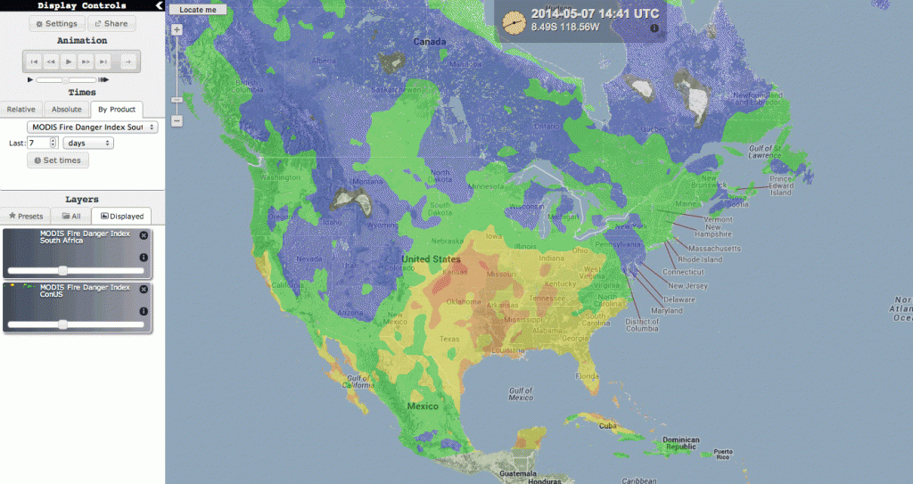
RealEarth (realearth.ssec.wisc.edu) allows users to blend information from various sources, overlay multiple products, and probe the resultant images to glean scientific insights.
One could look at RealEarth as a supplement to Google Earth for viewing near real-time satellite images and products. A satellite transmits data, an image is created, and then RealEarth enables the user to freely pan and zoom that image, or set of images as an animation over time.
“You get a lot of control over how it looks, for print or on a screen,” Dengel said, adding that RealEarth offers a simple interface for sharing imagery on social media or embedding onto a webpage. It is also supported on a variety of devices, operating systems and browsers.
Kathy Strabala, an SSEC researcher studying meteorology and remote sensing, uses RealEarth for her team’s IMAPP (International MODIS/AIRS Processing Package) project, a NASA-funded effort to enable direct broadcast researchers— those who work with earth observation data transmitted in real time from a satellite to a ground receiving station—to produce earth observation products.
Strabala’s involvement is in keeping with one of the primary goals for RealEarth.
“We wanted a resource for the Center,” Dengel said, “that would make it easy for our researchers to input their data and share views of their science with other investigators.”
And RealEarth accomplishes that goal. In addition to Dengel, Parker and Batzli’s efforts with the project, Dave Santek, Nick Bearson, Tommy Jasmin and Bill Bellon of SSEC have also contributed to the development of RealEarth.
While large institutions such as SSEC, NASA’s Langley Research Center, NOAA’s National Severe Storms Laboratory and the National Weather Service are high on the list of RealEarth users (some host RealEarth products from CIMSS and the SSEC Data Center on their own websites’ viewing interfaces) Dengel and Parker say the team designed RealEarth with the public in mind, hoping that non-scientists could easily use and access this information.
For example, a schoolteacher could use RealEarth in the classroom, tapping into ready-made presets or creating their own image by overlaying different products. This would allow students to view the Earth from a global scale all the way down to very high-spatial resolution—a pixel size of a mere six inches in Madison and about 18 inches for the state of Wisconsin. Other than educators, the two primary target user groups are researchers outside of SSEC and local National Weather Service offices.
Although RealEarth is not analytical, it serves as a “rapid data visualization tool” for those who are interested in combining the weather and Earth Science, Batzli said.
Parker said he feels that RealEarth makes it easy for researchers to upload their data, simply requiring them to save files using a standard nomenclature.
“We wanted to tap into an existing workflow,” Batzli added, meaning that users would not need a lot of extra training to use RealEarth, and could use skills that are common and nearly universal among scientific disciplines.
There are also free Android and iOS apps powered by RealEarth called WxSat (Weather Satellite), which have been in use for more than a year. The apps offer visual access in mobile devices to the same weather satellite imagery, formatted for scientists to use in their work. Similar to the original version, a primary aim for these apps was open-source access to data and images, with a low barrier to entry.
“It does the math for you behind the scenes,” said Parker, who is the main app programmer.
Looking ahead, Dengel said the team is continually developing new products and features. Right now that means creating a probe that is more user-friendly, allowing all visitors—novice and expert alike—to dig into the data and extract even more information from the experience.