Graduate researcher sees improved accuracy with new temperature validation method
by Sarah Witman
Validating the measurements taken by instruments onboard a satellite is a basic and necessary process of satellite meteorology. Another measure, sometimes a non-satellite measurement, is used as a reference point or standard in order to verify the integrity of the satellite data – a process that can be further complicated with variations in time and space. The method of choice for this type of data validation, then, varies slightly among scientific communities.
Researcher Michelle Feltz, as an undergraduate at the University of Wisconsin-Madison, undertook the challenge of developing one such method. The results of her research were recently published in the Journal of Geophysical Research, in a paper on which she was lead author.
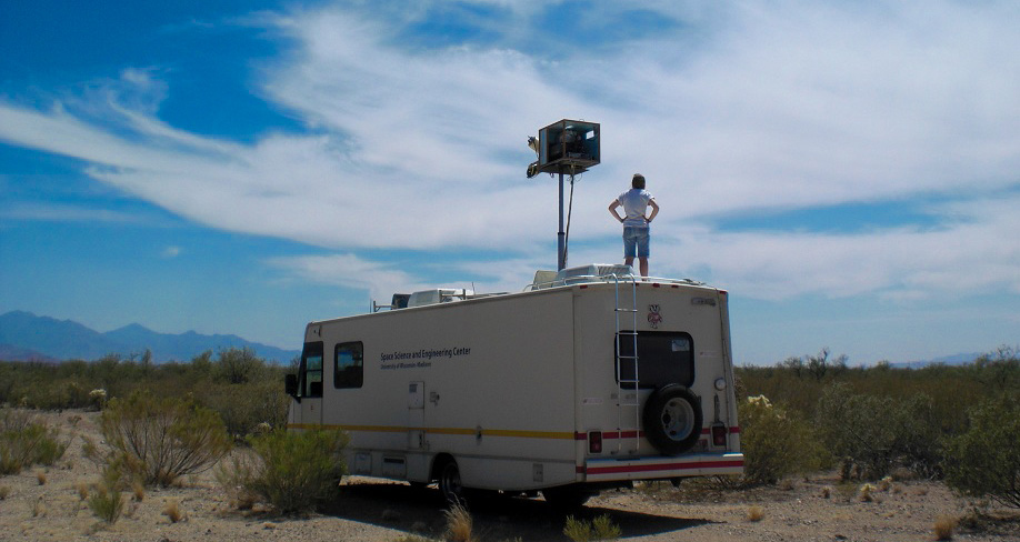
SSEC researcher Michelle Feltz in Tucson, AZ in May 2013. Photo Credit: Bob Knuteson
Feltz, now a graduate student in the University’s Department of Atmospheric and Oceanic Sciences, never thought that years of data analysis would culminate in an entirely new methodology for validating temperature measurements from weather satellites, with potential applications for studying climate. Nor did she likely envision her work would one day lead to correspondence with a group of scientists from the University Corporation for Atmospheric Research (UCAR) regarding the way it processes data.
The investigation began when Feltz’s adviser, Bob Knuteson, a Senior Scientist with the Cooperative Institute for Meteorological Satellite Studies, suggested that she begin an analysis of vertical temperature profiles in the atmosphere. Scientists would normally retrieve temperature data from satellites, and then validate those data by using forecast models, or by comparing them with data collected from radiosondes.
While radiosondes and forecast models remain the standard for temperature validation, Feltz said she no longer sees them as the best tools for this job. Her paper offers an alternative validation method using a remote sensing technique called GPS radio occultation.
GPS radio occultation is a technique for measuring properties in the atmosphere—in this case, temperature—which works by detecting a change in the radio signal emitted as electromagnetic radiation passes through the atmosphere. Knuteson describes the GPS radio wave as “a ribbon that cuts through the atmosphere.” As it does this, it gets refracted and can be detected with specialized instrumentation onboard low Earth-orbiting satellites.
Knuteson and Feltz theorized that GPS radio occultation data could be used to validate temperature profiles from infrared sounders, but the degree to which it could be done was unknown. They found that this method offered multiple advantages over traditional approaches.
To validate satellite sounder measurements—specifically, hyperspectral infrared sounders that collect and process information across the electromagnetic spectrum—GPS radio occultation offers the advantage of homogeneous global coverage: complete coverage that is unbiased with regard to land or sea.
“Traditionally, it’s been radiosondes that have been used to validate the infrared sounder temperature profiles. But radiosondes are very limited in their sampling, globally, because you can only launch so many weather balloons—usually over land, in the northern hemisphere. You are missing a lot of sampling,” she said. “With GPS, there is a lot more sampling.”
While the radiosonde provided the best estimate for atmospheric temperature, Feltz explained that she would feel more comfortable, as a researcher, relying upon GPS radio occultation rather than sounder data because it is capable of providing higher, and higher quality, vertical resolution in the temperature profile.
“It has advantages in the upper atmosphere rather than lower,” she said.
A primary thesis of Feltz’s paper, she said, is questioning whether GPS radio occultation could be used in place of radiosonde data.
“I don’t know if it should necessarily replace it, but it definitely offers a new viewpoint, a new way of looking at things,” she said. “It’s never a bad idea to look at something new and see what you can get out of it.”
GPS radio occultation has other advantages—it is thorough in terms of time and space as it collects data on a full diurnal cycle and at each latitudinal zone.
Additionally, while Feltz said she thinks a forecast model is still valuable in its own right, she has found modeling to be less accurate when dealing with data from sounders. The sounders onboard polar orbiting satellites scan in-sync with the sun in highly repeatable orbits, collecting swaths of data at distinct times of the day. GPS radio occultation offers pseudorandom sampling in time and space to validate those data.
Feltz explained that the trick to validation is matching up the time of the GPS retrieval with the satellite measurement at that precise time.
“You really have to think about where and at what time you’re taking these measurements. … You have to look at their different characteristics,” she said. “We had to learn about the different measurement techniques, and then go from there.”
Current sounders measure infrared radiation emitted by the Earth, whereas GPS radio occultation, she said, is more like sending out laser beams to do the same job.
“A lower earth orbiter satellite tracks this laser as it is being occulted, or partially concealed by, the atmosphere,” Feltz continued. “The measurement is based on the time difference, or the phase difference, of the wave, how it interacts with the Earth’s atmosphere.”
Furthermore, she said GPS radio occultation provides an independent, SI-traceable measurement, meaning it has a high level of certainty with internationally accepted standards. In contrast, sounder products are sometimes tuned to agree with medium range forecast model analyses and thus are not independent in the way GPS radio occultation offers.
“Models also ingest satellite data, so when you’re comparing satellite data against models that ingest it, you don’t know exactly what you’re comparing it to because it’s not completely independent,” Feltz explained. “Measurements from GPS RO and sounders are very independent from each other, which allows you to make a decent comparison.”
Her paper states that GPS radio occultation has potential for high accuracy in the upper troposphere to middle stratosphere, places where there is little water vapor. The high-accuracy clocks on GPS are known for providing highly stable, highly reproducible results, helping to prevent bias as well as total error. GPS radio occultation data has inherently less noise. During the reprocessing of data, noise can cloud results and impact bias.
There are a number of possible applications that could benefit from the ability to pair GPS radio occultation and radio sounder datasets, Feltz said, in terms of validation. In particular, minimizing bias and error could be especially important when studying climate, she pointed out, because it is a topic that relies on trends over many decades.
“Climate research is an important use of the data, especially,” she said. “In order to detect trends in climate, you really need an accurate measurement, because any uncertainty in your data is going to affect how long of a time period you need to detect a certain trend. So, by using these [GPS RO and sounder] measurements together you can have a greater certainty in what trends you are seeing in the data.”
“I think this could become an interesting issue in the future—what kind of measurements you need to detect climate change. I think you have to look at the best of both products and not necessarily say one is better than the other,” she said.
Feltz is not the only researcher anticipating the application of her methodology to climate studies. In the process of her data analysis, she found an interesting result, one that UCAR—the organization responsible for processing all radio occultation data in the United States—has said may hold advantages for their climate data processing.
Under Knuteson’s supervision, Feltz had begun investigating and comparing temperature profiles: data that had been retrieved using COSMIC, an NCAR/UCAR network of six satellites, and GRAS, a EUMETSAT instrument, both of which collect atmospheric data through GPS radio occultation.
When Feltz embarked on that project, Knuteson expected that the measurements would agree with one another—after all, these instruments are supposedly collecting the same type of data: vertical temperature profile measurements in the Earth’s atmosphere. He thought Michelle would write a paper highlighting the similarities found, along with some slight deviations.
To their surprise, though, she found something quite different. Contrary to their expectations, the instruments were reporting highly disparate results, especially at high and low pressures.
“The Feltz comparison suggests a systematic bias between COSMIC and GRAS temperature profiles,” Knuteson wrote in a CIMSS weekly report earlier this month, “which increases with altitude in the stratosphere and can exceed one degree.”
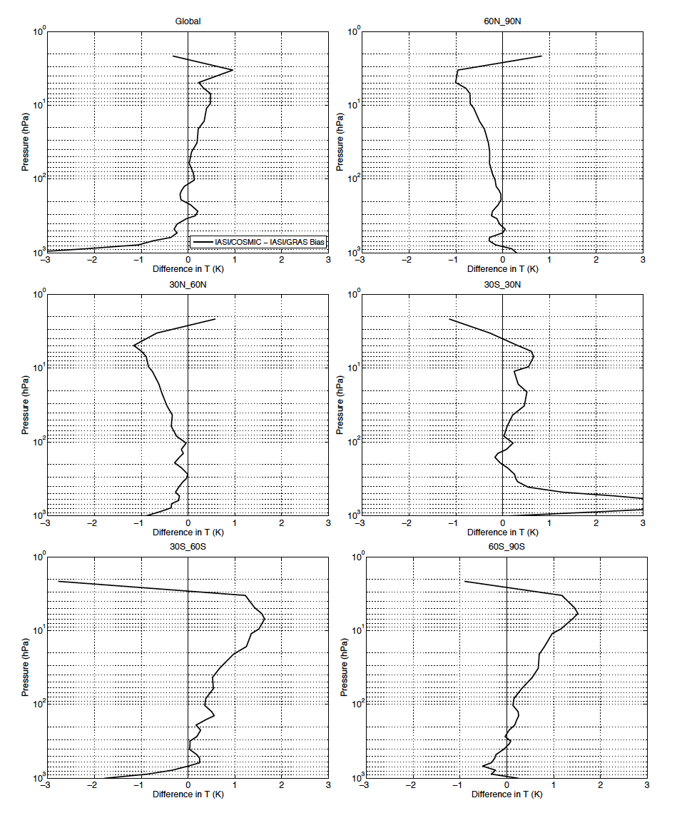
Feltz’s data analysis, shown in the above figure, revealed a bias between COSMIC and METOP-A/GRAS temperature profiles.
To confirm what she had found, Feltz wrote to the COSMIC Data Analysis and Archive Center team at UCAR in July 2013, the organization from which she and Knuteson obtain all of their GPS radio occultation data. She asked UCAR for documentation that would show any specific differences in the processing of data from either source, either supporting or disproving a possible temperature bias between them.
“When we compared the bias results from [COSMIC and GRAS] for five different latitude bands, we found an interesting result,” she wrote to UCAR in an email. “We see an interesting pattern.”
Feltz corresponded with UCAR-COSMIC Software Engineer Doug Hunt, explaining the results of her study and its potential uses. One day, Hunt responded with exciting news: A couple of scientists in his group, Sergey Sokolovskiy and Ben Ho, had taken an interest in her query, discussed it, and attempted to duplicate her results. He reported they had gone on to confirm her results independently, using only the UCAR-processed COSMIC and GRAS temperature data.
“For the currently available data on the CDAAC website, our results matched yours pretty closely for temperature,” Hunt wrote.
They explained that the difference in results stemmed from differences in data processing. A climatology technique called “first guess” had been used to a greater degree with the COSMIC data, to account for more noise in those data, while less of that technique had been applied in processing the less-noisy GRAS data. Hunt said they found this practice could lead to latitudinal biases. They found that when they tried an alternative type of computation, known as bending angle, one that does not employ first guess, that bias disappeared.
“We are working on a new version of our radio occultation inversion code that mixes in first guess in the same way for each occultation regardless of how noisy it is,” Hunt continued. “This has advantages for climate processing.”
To mitigate this bias, UCAR plans to alter its method for processing COSMIC data, starting later this year.
“This is a neat example of how science should work,” Knuteson said of the experience with UCAR. “You do good work independently, and then other people who are interested in it and its implications will evaluate it.”
While the discovery may be a small one, Knuteson feels it is a praiseworthy example of Feltz’s work ethic.
“I am excited. The sounding data Michelle put so much time into, all this work she did—and the first thing she found was this bias,” he said. “She is very skeptical, so it was important to her to confirm and do everything herself. It’s a good scientific trait.”
Feltz’s manner of speaking about her research is very deliberate, selecting each word carefully so as not to mislead or overreach. At the same time, it is clear that she personally enjoys the topics she and Knuteson have been working on—especially a side project where they launched radiosondes from the roof of their workplace, the 15-story Atmospheric, Oceanic and Space Sciences building at UW-Madison, as well as from Park Falls in northwoods Wisconsin. Feltz grew up in the Midwest and enjoys the outdoors, but she had more to say about the chance to validate her data firsthand.
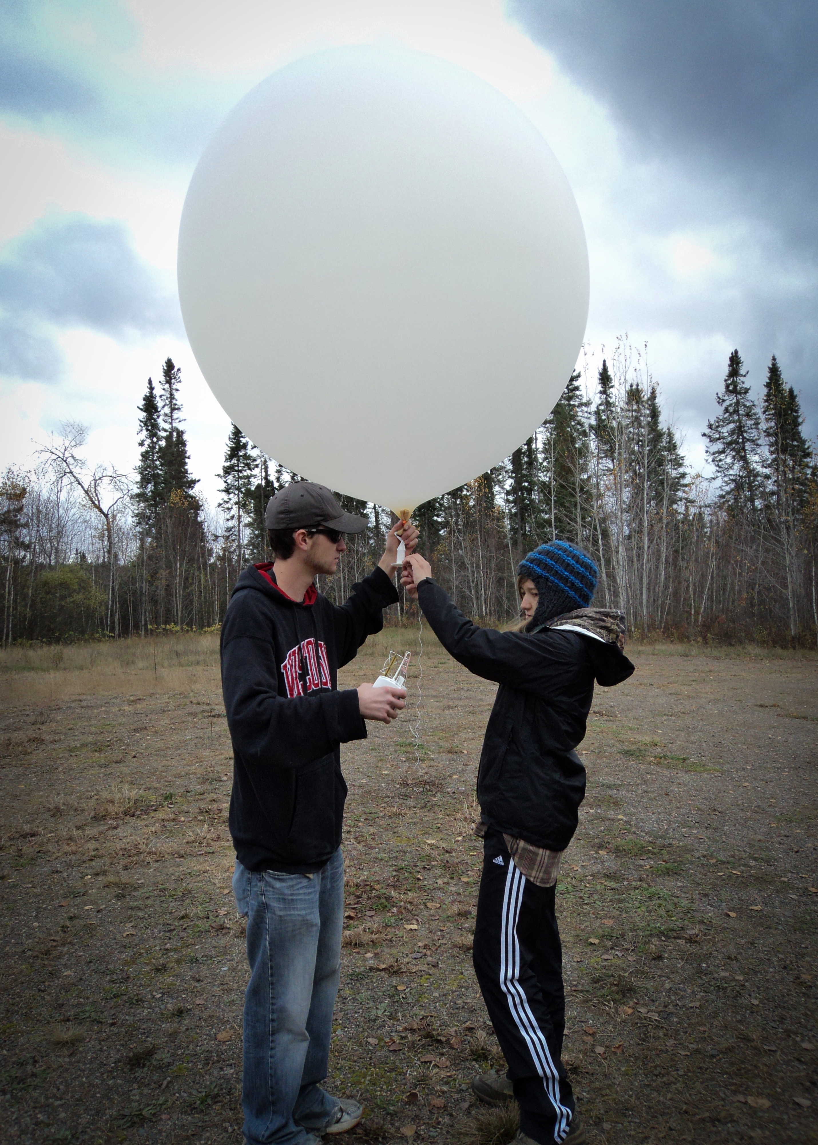
Launching radiosondes in Park Falls, Wisconsin. Photo Credit: Amanda Gumber
“We launched weather balloons and we could compare different temperature profiles from each instrument. That was a really fun project for us to look at, for ourselves, what the temperature profiles looked like compared to each other, how well the different instruments performed, and in what conditions they do better,” she said.
“I definitely enjoy the topics we have been working on,” she added. “Looking at instrumentation of the satellites and working with the data in a way that you can actually use it.”
She said other scientists seem to be receptive and accepting of the method, during the few conferences at which she has presented her research so far.
Next on the horizon for Feltz? She will look at the best way to combine the information provided by GPS radio occultation and from the new CrIS sounder on the Suomi-NPP satellite.