Cause and effect: SSEC team studies rare type of snow in northern Michigan
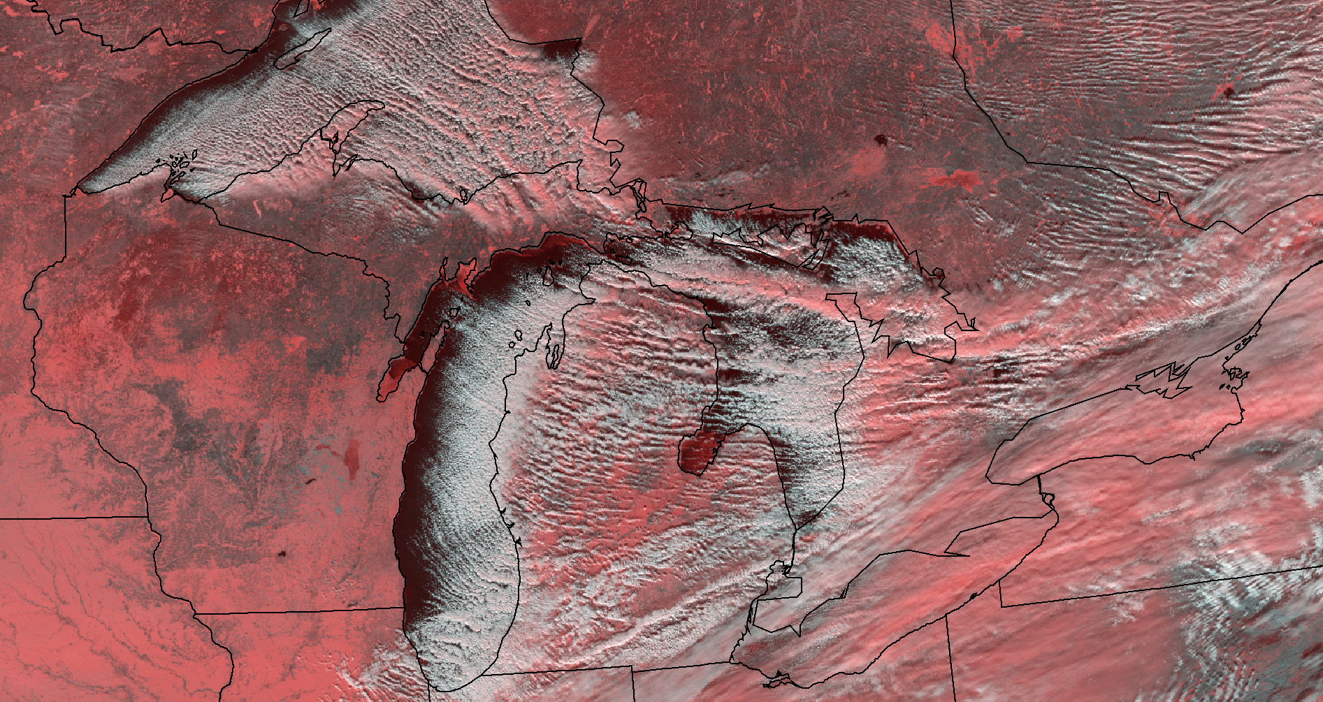
In satellite imagery, lake-effect snow appears as narrow, banded structures. Here, the long streaks of clouds formed by cold air interacting with open water are visible over the Great Lakes from Suomi NPP. False color (red) differentiates ice and snow from clouds. Credit: CIMSS.
Weather and climate field experiments can often fling the scientists who conduct them to the far corners of the Earth — from Iceland to the Ross Ice Shelf. Sometimes, though, the best places to study these phenomena are much closer to home.
Mark Kulie, a scientist at the Cooperative Institute for Meteorological Satellite Studies (CIMSS) in Madison, WI, is the principal investigator for ongoing fieldwork just a few miles from where he grew up, at the Marquette National Weather Service (NWS) Office on Michigan’s Upper Peninsula.
The NASA-funded project, in its second field season, has collected more than a year’s worth of data on lake-effect snow: a fluffy but prolific type of precipitation that forms when freezing air masses move over warmer lake water. Made up of mostly air, it has about a third of the water content of other, denser types of snow.
Lake-effect snow is most common in the Great Lakes region, though it can be found elsewhere, such as near Utah’s Great Salt Lake. It often causes intense blizzards, a sudden “wall of white.”
“The same area gets inundated hour after hour,” explained Kulie, who recalls learning to drive on roads that are caked with ice and snow five months out of the year.
A boon for the UP’s skiing, snowmobiling, and snowshoeing industries, lake-effect snow contributes substantially to the 150-300 inches of snowfall that northern Michigan receives on average each winter — though just how much of that total comes from lake-effect snowfall is unknown.
Kulie, who has been in the field for nearly two decades, decided to use his knowledge of satellite meteorology to help study the phenomenon.
“It is near and dear to my heart, both personally and scientifically,” he said, noting that this type of snowfall is what first sparked his interest in studying atmospheric science.
However, using satellites to garner a more sophisticated understanding of lake-effect snow, and possibly help affected populations prepare, comes with its own set of challenges.
For one, lake-effect snow is relatively shallow – often forming less than a kilometer off the ground – making it almost impossible to detect with a space-borne instrument, such as the radars on NASA’s CloudSat and Global Precipitation Measurement (GPM) satellites. Even grounded weather radar, pointing upward at too high of an angle, is liable to miss lake-effect snow.
Since beginning the project in late 2013, Kulie’s team has deployed two instruments to overcome these limitations – to “fill in the gaps” that existing satellite instrumentation are missing, he said. Not only that, but he hopes they could inform future satellite missions, by measuring just how much snowfall is being overlooked.
A commercial, off-the-shelf product called a Micro Rain Radar (MRR) is typically used to study rain, but the team developed an algorithm that allows them to focus on snow as well. The MRR sends out microwave radiation, Kulie explained, and, based on how much of that radiation is reflected (or “backscattered”), they can calculate the reflectivity of the snow as well as the speed at which a population of snowflakes is falling.
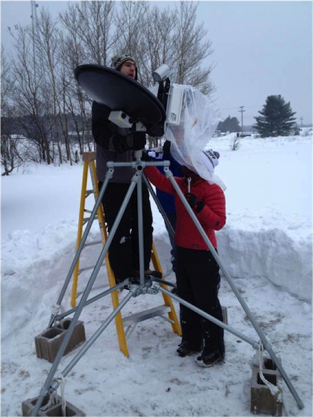
Mark Kulie and team deploy the Micro Rain Radar at the Marquette National Weather Service Office in Michigan. Credit: Mark Kulie, CIMSS.
The second instrument, the Particle Imaging Package (PIP) is able to measure the size, density, and fall speed of each snowflake. PIP is a more specialized instrument, designed at NASA Wallops, which team-member Claire Pettersen says is an “ingenious” solution for imaging snowfall.
“It’s basically a very bright light with a camera situated such that the snowflakes falling between them are imaged,” she explained.
The “shadow image” produced by PIP is not very detailed, but it shows particle size distribution, which is useful for converting MRR’s reflectivity observations to snowfall rates.
Pettersen, a dissertator in the Department of Atmospheric and Oceanic Sciences at UW-Madison, was brought onto the project through NASA’s New Investigator Program in Earth Science, an effort to fund early-career scientists. Having studied physics and engineering as an undergraduate and graduate student, respectively, as well as earning a second master’s and doctorate degree in atmospheric and oceanic sciences, she brings a double-pronged set of skills to the project. An engineer with the Space Science and Engineering Center, she also has a background in fieldwork and instrumentation.
Working primarily with microwave equipment, Pettersen helps deploy and debug the instruments, and performs data analysis and programming. The NWS office hosts a browser she developed, which provides plots on snow reflectivity, snowfall speed, particle size, and particle density based on daily, automatic updates from MRR and PIP.
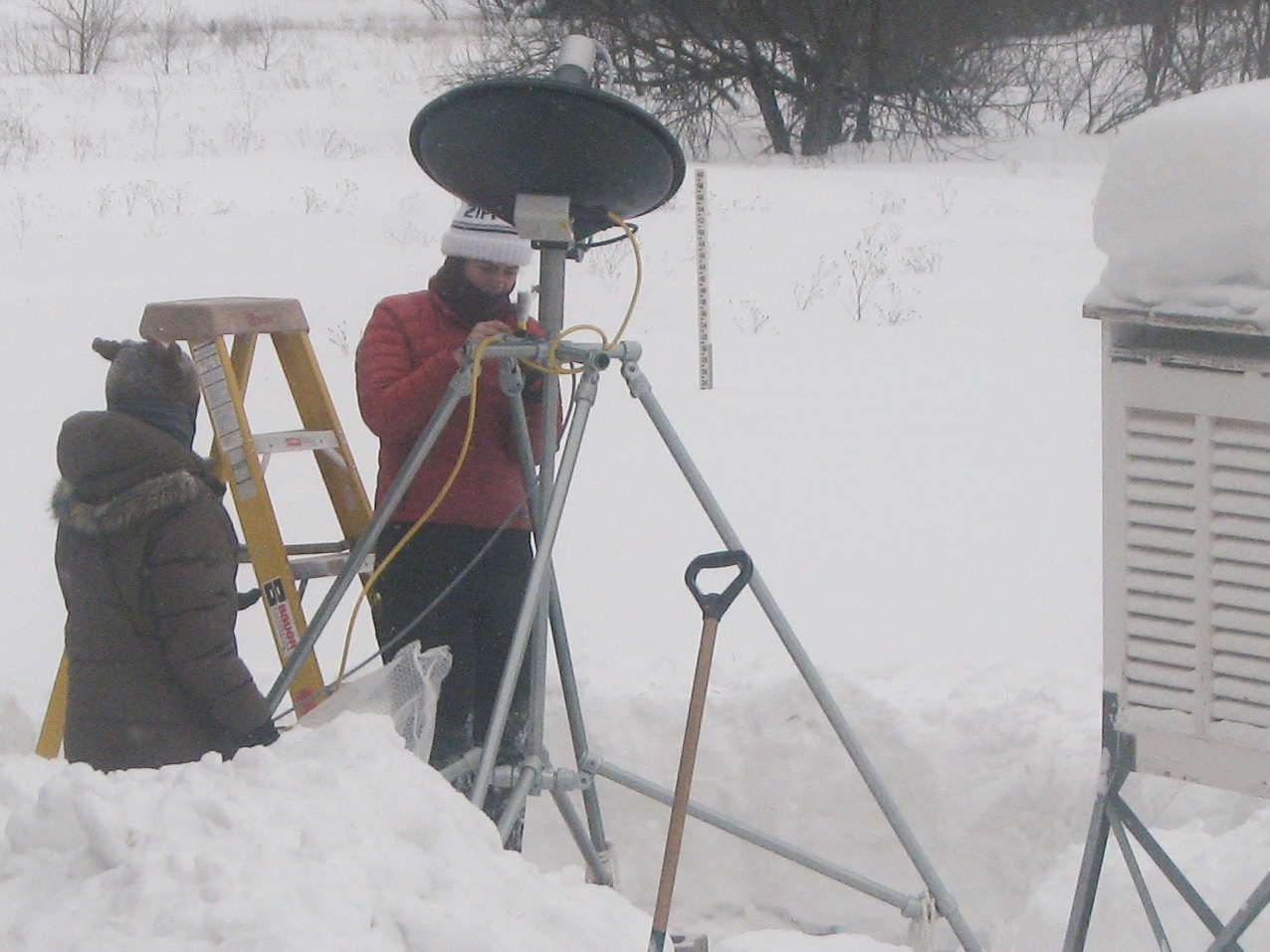
Claire Pettersen and Elin McIlhattan deploy the MRR. Credit: Mark Kulie, CIMSS.
Using the data they’ve collected so far, Pettersen, Kulie, and the other co-authors hope to publish a substantial case study paper later this year, detailing the specific meteorological conditions that must be present for lake-effect snow to form.
Deploying the instruments in mid-January meant they were only able to collect data immediately before and after Lake Superior froze for the winter in their first season. (Since lake-effect snow is generated by cold air interacting over a large body of open water, said Kulie, when the lake is frozen, “the lake-effect snow machine is turned off.”)
This past winter, though, their luck was much better. Upper Michigan had a “historic” snowstorm in early November, he said, during which a synoptic snowstorm (found mostly in the mid-latitudes, and capable of producing thunder and lightning) transitioned into a lake-effect snowstorm. For about a 12-hour period, both types of storm occurred simultaneously.
Scientists don’t know just how rare this phenomenon was, since it occurred at such a shallow altitude that, without their ground-based instruments, it would have been missed.
“No one has ever studied that transition period before,” Kulie marveled. “We were really fortuitous… We have a prime case study to investigate the different angles of how these snowstorms evolve.”
While lake-effect snow has a mostly local impact, there are other forms of shallow clouds and shallow snowfall, including bay-effect snow and ocean-effect snow, around the globe. Knowing more about these weather processes is an important step for studying climate.
“With global climate change, we may see systematic changes in this type of snowfall 100 years from now,” Kulie said. “It is a science question that will definitely be pursued in the next few decades.”
Modeling these weather processes is key to understanding them and their impacts on climate change. Unfortunately, most scientific models are complex, with myriad parameters to set. An ongoing, perhaps infinite, task for modelers is improving the accuracy of existing parameters, and sometimes adding new ones.
In weather and climate models, Pettersen said, there are some holes to fill. The hope is that, as the team continues to develop this ground-based observational dataset on lake-effect snow, environmental scientists will use those data to validate their climate models.
For example, Kulie said, the Center for Climatic Research, housed in the same building where he and Pettersen work, is currently conducting modeling studies on this topic.
In the near-term, the project is providing a service for weather forecasting. Weather radar does not always capture the details of lake-effect snow that would interest forecasters, so the Marquette National Weather Service Office taps into the real-time data stream to support their forecasting and modeling on 12-hour to two-day time scales.
The value of that partnership goes both ways, Kulie noted, as the office has lent its “backyard” for data collection. Together, they have forged a “fun and productive” working relationship, he said.
Now that the instruments and browser site are up and running, the team need only make the short trek up to the UP for a few check-up trips per year: before, during, and after each season, and in the event of equipment failure, which they have so far, fortunately, avoided.
To Kulie, though, this will always be more than a field site.
“If you ask people who live in the Upper Peninsula of Michigan about the uniqueness of their environment, most people don’t really know — it’s just a way of life,” he said. “It took me moving away from the upper Midwest to realize what a fantastic location it is for this very unique type of snowfall.”
by Sarah Witman