CIMSS scientists work to broaden direct-broadcast capabilities with CSPP Geo
by Sarah Witman
Direct broadcast data from some polar-orbiting satellites, such as Terra, Aqua, and Suomi NPP provide an extraordinary service to users: The satellites orbit in a north-south direction over the poles, transmitting Earth-observation data — for free — to anyone on the ground with a receiver. The data are real-time and local to the receiving station, two major benefits for forecasting and other applications.
For years, the Cooperative Institute for Meteorological Satellite Studies (CIMSS) has supported these users of polar-orbiting satellite data through the development of direct broadcast software, namely the International TOVS Processing Package, and an advanced version, the International ATOVS Processing Package. These packages, supported by a group of CIMSS scientists with the Community Satellite Processing Package (CSPP) group, allow users to retrieve atmospheric temperature and moisture profiles, total ozone, and other parameters from polar-orbiting satellite measurements.
Since 2013, CSPP scientists have been working to further broaden these capabilities with the Community Satellite Processing Package for Geostationary Data (CSPP Geo), a data-processing package that facilitates the use of direct broadcast data from geostationary satellites.
Positioned tens of thousands of miles above the Earth’s surface, along the equator, geostationary satellites keep pace with the rotating globe, making observations of the same location throughout the day — in contrast, polar-orbiting satellites cover swaths of the spinning Earth, scanning the entire surface about twice per day.
CSPP Geo is currently being used to process GOES direct broadcast data, and the group also has plans to release software for Himawari-8, a Japanese geostationary satellite launched in 2014. But that’s just the tip of the iceberg. The CSPP Geo team, led by principal investigator Liam Gumley, is taking strides to ensure that users are fully prepared when the first next-generation satellite, GOES-R, launches in 2016.
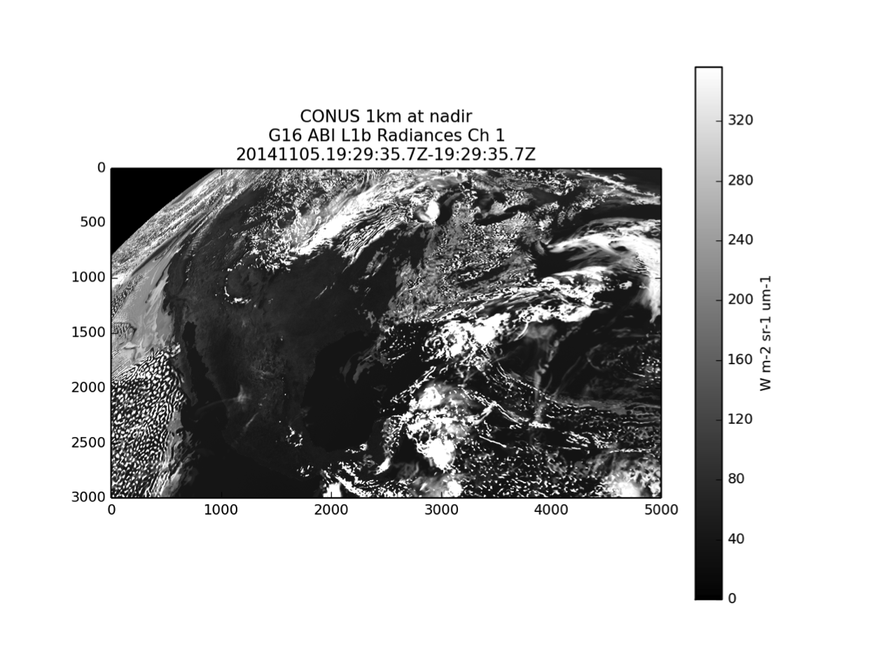
Visible-light imagery of the continental U.S. created using simulated Advanced Baseline Imager (ABI) data processed with CSPP Geo’s GRB package, named for GOES-R’s future direct broadcast stream: GOES ReBroadcast (GRB). Credit: CIMSS.
The Advanced Baseline Imager (ABI), the main GOES-R instrument that will be used to monitor weather and environmental conditions, will have the ability to deliver a full disk image of the globe every five minutes, and concurrently take more detailed images of severe weather as often as every 30 seconds.
Equipped to deliver imagery with much higher spectral, spatial, and temporal resolution — four, four, and five times, respectively — than the current GOES satellite, GOES-R will produce huge datasets, which will in turn need to be processed.
“From a processing perspective, GOES-R poses a challenge to keep up with the larger amounts of data,” said Graeme Martin, project manager for CSPP Geo. “It is important that future users of those data be prepared to receive them, a major part of this project.”
Martin said direct broadcast from a geostationary satellite, such as GOES-R, provides a helpful backup for users, such as the National Weather Service, who already receive those data via a terrestrial network.
“For users who are in remote locations or who have limited Internet connectivity, a direct broadcast receiving station may be the only way to receive these data. And for users who do have a good connection, direct broadcast can serve as a backup in case of a failure in the terrestrial network,” he said.
One of the main benefits of direct broadcast is that it shrinks the time that elapses from when the observation is taken until it is available to the user, compared to distributing the data via a terrestrial network, Martin added.
“Direct broadcast is an appealing option in a real-time processing environment where reliability and latency are critical considerations, such as fire detection or other hazard warning systems,” he explained.
CSPP Geo has made three public releases this year: a Global Vector AutoRegression (GVAR) package released in March 2015, which processes data from the current GOES imager, and two versions of a package, released in April and June 2015, both of which work with a simulation of the future GOES-R direct broadcast stream: GOES ReBroadcast (GRB).
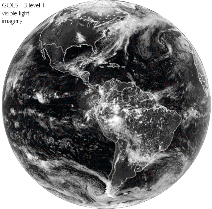
Six full disks: GOES-13 level 1 visible-light imagery, GOES-13 level 2 fog imagery, GOES-13 level 2 cloud-type imagery, GOES-13 level 2 cloud-top-temperature imagery, GOES-13 level 2 cloud-mask imagery, and visible-light imagery created using simulated Advanced Baseline Imager (ABI) satellite data processed using CSPP Geo’s GRB package. Credit: CIMSS.
The group will continue to release new versions of the package before, during, and after the launch of GOES-R — in particular, they plan to add more advanced (level 2) products and improve upon existing products. In addition, the team has placed a high priority on user support and training.
“We’ve had substantial interest in CSPP GEO from domestic and international users,” Martin said. “Like all our packages, we want to ensure the software is easy to download and install, can be run on a Linux machine, and that anyone can download it from our website.”
Scientists in the algorithm working-group (AWG) at CIMSS have been hard at work the past six years developing algorithms for the ABI instrument, which is now fully integrated into the spacecraft. Those algorithms will help gather information on cloud properties, total precipitable water, and total ozone, to name a few. Using them with the GOES imager and the AHI — Himawari-8’s imager that has many similarities to the ABI — is the perfect testing ground for GOES-R.
A highly collaborative effort, CSPP Geo provides an avenue for disseminating these updated science algorithms, and to help further develop and refine them.
“One of our goals with CSPP Geo is to take those advanced, state-of-the-art algorithms, and get them out to users so they can be ready to generate products from the GRB data stream,” said Martin. “The idea is to get users accustomed to working with GOES-R products now, before the satellite is launched, by running on data from existing satellites. We also want to evaluate algorithms’ performance and get some feedback.”
Products generated during this early testing period can also be used for forecasting and other applications, he added.
Under Gumley’s leadership, the team is making a unique contribution to preparations for GOES-R. Vendors who build and sell receiving stations will likely integrate CSPP software into their systems and distribute them together. In this way, Martin said, CSPP Geo is helping to encourage receiving station vendors to provide early support for GOES-R.
In the big picture, said Martin, the beauty of having direct broadcast capabilities with GOES-R is that its myriad, high-quality data “will come down through that stream, with no reduction in quality.”
The ability to effectively interpret data can be as valuable as the data themselves. Through its development of direct broadcast software packages, CSPP Geo is providing a reliable tool for current and next-generation users around the world.
Note: CSPP GEO is funded by the NOAA GOES-R Risk Reduction and Ground Systems Program.