SSEC research interns forge studious camaraderie
by Sarah Witman
It is uncommon, perhaps even unprecedented, for four University of Wisconsin-Madison graduate students from the same class to be hired on as Space Science and Engineering Center (SSEC) research interns straight out of school. But, in the past year, current interns Amanda Gumber, Michelle Feltz, Aaron Letterly, and Alexa Ross have done just that.
Once office-mates on the Atmospheric, Oceanic and Space Sciences building’s 13th floor (informally known as the graduate student office), these atmospheric scientists are using the skills and interests they developed as students to pursue real-world applications. While each of them works with a different SSEC scientist on different research projects, the relationships they built in room 1311 continue to serve them well now, as they face the challenges of full-time research.
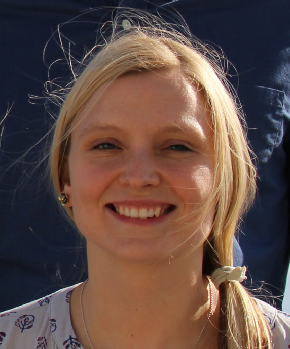
Amanda Gumber
Gumber works with SSEC scientist Mike Foster, primarily working to finish up a project she began as a master’s student: manipulating data from the Moderate Resolution Imaging Spectro-radiometer (MODIS), an instrument onboard NASA’s Terra and Aqua polar-orbiting satellites, to examine 3D radiative cloud effects.
“I play with the data,” she summarizes jokingly, explaining that she uses a method developed by Foster to retrieve distributions of cloud liquid-water path over partially cloudy scenes.
She has applied Foster’s method over the MODIS record in order to create a dataset that adjusts for distributions of cloud liquid-water path in marine liquid clouds. Essentially, the method adjusts horizontal distributions of cloud optical properties to be more consistent with the observed visible reflectance, which is useful in areas where cloud optical retrievals have either failed or are considered to be low-quality.
They have used the method to do comparisons among other satellites and data sets, too. Ultimately, they use a 3D Monte Carlo radiative transfer model to identify and quantify the 3D radiative cloud effects that occur from using these adjusted distributions of cloud optical properties throughout the MODIS record.
Gumber became interested in studying clouds early on, particularly via satellite. Because of their close proximity, clouds are ultra-accessible to satellite instrumentation – especially polar-orbiters, such as MODIS, that soar a few hundred miles above the Earth’s surface. Satellites also offer the advantage of a global view in just a day or two, versus highly localized ground-based instruments that cover a much narrower swath.
“Satellites have offered the opportunity to get a global record of clouds for the first time,” she says. “I like it because it’s a field that still has a lot to be explored.”
And, with more than three decades’ worth of global cloud data available, Gumber says, it’s a thrilling time to be entering the field.
“We’re getting to a cool part in time, where satellites have been getting cloud data for 30-plus years, so it’s helping with climatology,” she says. “You can use the record for climate-related analyses.”
As an undergraduate student at UW-Madison, Gumber had the opportunity to do some software testing for SSEC’s longest-running data visualization program, the Man-computer Interactive Data Access System (McIDAS). She would use the program and provide feedback to SSEC scientists in the McIDAS working group. After that experience, she enrolled in a remote-sensing course offered through the Department of Atmospheric and Oceanic Sciences (AOS) that gave her exposure to the full range of capabilities offered by satellites and other instrumentation. From there, she set her sights on a graduate degree in remote sensing.
Aside from making eye-catching data visualizations of her own, Gumber says her favorite part of research has been the satisfaction of getting results.
“It’s great when you see something you made actually work,” she says. “You apply a specific method and you get this output and you see how cool it looks. To know that you actually did something, and it’s not just random noise…that’s really rewarding.”
To get to that scientific sweet-spot, Gumber often enlists the help of Foster or other scientists in the building, including the other interns. Having them as a sounding board has been a big help as she tackles coding challenges for the first time.
Being able to focus on her research full time has helped, too, as she works on developing her master’s thesis into a paper for publication. For now, she explains, there is still at least another year to go with that project. And afterward?
“I think one day it would be cool to work on more of the algorithm development side of the process,” she says. “I think that’s fascinating.”
No matter what role she may take on in the future, she says, one thing will stay the same: “Ultimately, you’re always working toward the same goal: Let’s get good measurements, so we can input them into models to get reliable results.”
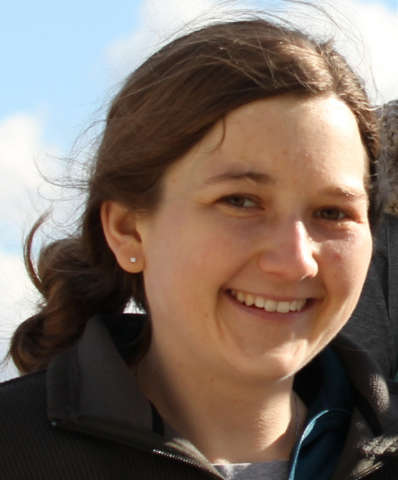
Michelle Feltz
Feltz has been working with SSEC scientist Bob Knuteson since she was an undergraduate student. Transitioning from undergraduate to graduate coursework was fairly seamless, she recalls. But the transition to research intern, while an informal process, has involved more of a mental shift, she says.
“There’s more responsibility, more independence,” she describes. “I feel like I need to be taking more initiative, making more decisions for myself.”
“I think I’m learning how research is done,” she continues. “I always need to be thinking about the bigger picture, not just one project.”
Graduate school, she says, was an important venue to learn the basic tools she would need to excel as a researcher: how to use relevant computer applications and models, how to code, how to write a grant proposal and publish papers. It imparted more universal skills, as well, she says, such as computer organization skills and efficient work habits.
“Once you have that base, where you have various tools you can work with, then you can easily modify them and use them for another project,” she says.
While she is unsure what will happen once her one-year internship ends, for now, she says, she is enjoying the opportunity to learn more about what she might want to do next.
“I really enjoyed research during grad school, so I thought being a research intern would be a good opportunity to continue working on those projects and test out if I really want to do research as a career. I think SSEC is great, and so is Madison, so I thought I should take the opportunity,” she explains.
Knuteson has been a wonderful mentor to help find funding and projects that would interest Michelle, she says. Her work is currently divided among three distinct projects.
Fifty percent of her time is spent working with Knuteson and SSEC scientist Eva Borbas on NASA’s Making Earth System Data Records for Use in Research Environments (MEASURES) endeavor.
Satellite instruments, such as MODIS and the Advanced Spaceborne Thermal Emission and Reflection Radiometer (ASTER), she explains, make measurements from which scientists can derive surface emissivity and land-surface temperature. There were several independent datasets of this type over different time ranges, different resolutions, and different regions of the Earth – MEASURES proposes to merge all these datasets together to make “one huge, unified dataset,” she explains.
Borbas has already done a great deal of work on MEASURES, including validating the accuracy of a land emissivity variable: a job that has been passed on to Feltz. Using code that Borbas developed, she compares a calculated brightness temperature quantity to a satellite-measured brightness temperature to validate that their high spectral resolution emissivity algorithm is working properly. That algorithm will then transition to use in operational weather models that could be used by the numerical weather prediction community to improve weather forecasts.
Another 25 percent of Feltz’s time is focused on a validation project for SSEC scientist Lori Borg related to the National Oceanic and Atmospheric Administration (NOAA) Unique CrIS/ATMS Processing System (NUCAPS). The main purpose of NUCAPS is to generate environmental products from data collected by the Cross-track Infrared Sounder (CrIS) and Advanced Technology Microwave Sounder (ATMS) instruments onboard the Suomi National Polar-orbiting Partnership (NPP) satellite – and, in the future, data from the yet-to-be-launched Joint Polar Satellite System (JPSS-1 and JPSS-2).
Feltz’s role with the project is essentially an extension of her master’s thesis topic, which earned her the Lettau Award for Outstanding Master’s Thesis this spring. Her thesis explored the use of radio occultation – a means of making atmospheric measurements by detecting changes in radio signal caused by electromagnetic radiation passing through the Earth’s atmosphere – to validate soundings from satellites. She is analyzing a temperature dataset from Borg, validating the NUCAPS temperature products by comparing them to radio-occultation measurements: The difference between the two provides the percent error in the NUCAPS temperature data. They are currently working on a paper that will compare all available operational temperature products to radio-occultation temperature data.
A third project with which Feltz recently got involved is particularly exciting, she says, because the real-world applications are readily apparent. An aviation safety initiative out of Alaska, the project is examining the “cold pool” phenomenon. Aircraft cannot fly through cold air aloft, Feltz explains, because it’s too dangerous. So, scientists are trying to find ways to get real-time 3D observations available to forecasters. SSEC scientist Elisabeth Weisz, with whom Feltz will be working, and a number of scientists based at other institutions, are supporting forecasters by providing observations from infrared sounders.
Since Feltz’s area of expertise is validation using radio occultation, Knuteson had the idea to get her involved with the project, to see if her methods could be useful to them.
“If you can offer something to solve a problem that has societal benefits, that’s pretty cool,” she says. “Sometimes you are sitting in front of the computer with a piece of code…and it’s nice to be able to see you are making a difference.”
The group also sees some potential for international collaboration, perhaps with Johannes (Joe) Nielsen, a visiting scientist at SSEC from Denmark.
Right now, Feltz says, the project’s focus is on the U.S., but “those applications should be made widely available. A lot of potential opportunities are there for us to follow.”
As she’s come to understand, “that’s kind of how research goes. You have to be really proactive. If you see an opportunity to start a new project, and solve a new issue, you should follow that lead.”
For the time being, Feltz says, she’s excited to stay in research. It has taken a while to get comfortable, build her skills, and to figure out how best to do her job – and she says she’s glad to have the opportunity to take her time exploring.
“Research in this field is really fun because it’s always changing. You are constantly learning new things and getting to solve problems,” she says. “You might be working with other people to solve a problem or sitting at your desk all day trying to figure something out – both are fun in their own way.”
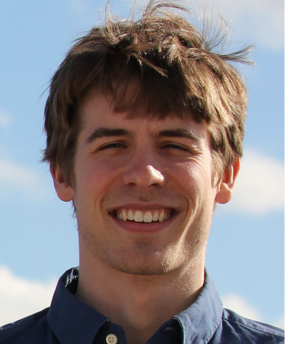
Aaron Letterly
Letterly has been working with Jeff Key, a NOAA Advanced Satellite Products Branch (ASPB) scientist based at SSEC, for more than two years: as a research intern since June 2015 and as a graduate student since August 2013. Their focus is Arctic sea ice.
The past few months, Letterly has been editing and adapting his graduate student thesis, discussing winter clouds and how they affect sea ice later in the summer, to turn it into a manuscript fit for a peer-reviewed journal – it was accepted for publication this winter.
His tasks as a research intern, he says, are for the most part continuations of what he did as a graduate student, however, his “responsibilities are expanding.” For example, he helps provide weekly products for sea-ice motion and weekly Advanced Very High Resolution Radiometer (AVHRR) values for cloud, sea, and ground surface temperature – important Arctic parameters that impact sea ice. This involves receiving data from satellite overpasses – typically 20-35 per day – and arranging the data together to create one mosaic-like image of the Earth.
“A neat thing you can do with a satellite image,” explains Letterly, “is compare it to the image you made yesterday, to see how far the sea ice has moved in a day – or a week, or a few months. … That’s how you derive sea-ice motion.”
Applying this technique over a longer period of time, scientists are able to look at averages in sea ice behavior over a span of years.
“Our satellite data goes back to 1982. … That’s pretty significant for sea ice,” he says. “We can look at a mini-climatology, changes that happen. It’s nice to have that track record. And that’s only going to expand further as time goes on.”
The end goal for the products that Letterly and others create is an online resource allowing scientists around the globe to access the data.
“We want to have a web-space … that provides these Arctic parameters, since we get a large volume of data and can do so much with it here,” Letterly explains. “If you are interested in the Poles, most likely, [we have] something that will interest you.”
Letterly became interested in sea ice through a small research project he did as an undergraduate at the University of Illinois at Urbana-Champaign in 2011. He was immediately drawn to the possible climate-change applications the data offered.
“When you look at an IPCC (Intergovernmental Panel on Climate Change) report, they talk about 20-year or 100-year changes. That always seemed so far away, like so much of an estimate. … But I did this project where we just looked at year-to-year changes of just sea ice. I was fascinated to see how changes in just this one substance (sea ice at the Poles) could change the albedo of the Earth so rapidly and so drastically in the course of a year. … The fact of whether or not there was ice had so much of an implication,” he recalls.
He did not know then that he would spend a substantial amount of his graduate and post-graduate years studying the subject, but “it’s evolved into some pretty fun research,” he says, “because it’s always changing.”
The concept of less ice growth indicating warmer temperatures, and more ice growth indicating colder temperatures, is more intuitive than many other environmental processes. Letterly says this is an advantage that sea ice has toward explaining climate science to a lay audience, who are able to see satellite images and easily draw important scientific conclusions from them. “I think that’s really fun,” he says.
Becoming a research intern was the “most attractive option” after graduate school for a number of reasons, Letterly says. Firstly, it would allow him to continue to build the relationships he had fostered as a student: with Jeff and the rest of his team at SSEC, and with the other interns.
The idea of taking the PhD qualifying exam, or moving away for another job, seemed like “a lot to put on my plate, especially since I had this great opportunity to keep doing meaningful and fun work with people I enjoy working with at SSEC,” he recalls.
Furthermore, he says, the position has enabled him to immediately jump into applying the skills and knowledge he has learned over the past few years, as well as begin to develop some new ones: how to make a job run faster, or how to write code so the output is cleaner. Everything he has learned on the job thus far, says Letterly, has been at an accelerated pace.
“As a research intern, if I need to learn something, it’s probably because I’m going to be using it every day for the next three months,” he says, “Things stick with me more than they did in grad school because of the constant repetition of tasks reinforcing what I’ve learned. It’s less theory, more application.”
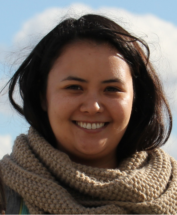
Alexa Ross
Of the four interns, Ross has perhaps strayed the furthest from her original area of study: She did her undergraduate degree in physics, at a small liberal arts college. Unlike at UW-Madison, one of the most prolific research universities in the country, there were almost no research opportunities available to her as an undergraduate. She had very little programming experience.
By the time she started applying to graduate schools, though, she had set her sights on studying something within the Earth sciences.
“Climate was interesting to me,” she recalls. Furthermore, she knew she wanted to work with big data.
“I liked the idea of big data, so I was looking into remote-sensing programs. Satellite remote-sensing piqued my interest because I had a little bit of a background in astronomy,” she explains. “So I was used to working with satellites, just looking outward instead of inward at the Earth.”
Upon starting graduate school at UW-Madison, Ross got involved in a modeling project with professor Tracey Holloway, working to answer big-picture questions about climate – but it wasn’t for her. She wanted the hands-on element of working with data. From then on she has worked under SSEC scientist Bob Holz.
“[Bob] gave me a big data project and I absolutely loved it. I took a programming class that semester, using MATLAB. Programming has always been super daunting to me, because I had never had someone to walk me through things, but I fell in love with the puzzle-solving aspect of it,” she says. “That was what got me into physics in the first place.”
Ross’ master’s thesis on the microphysics of a specific type of cloud ice offered a great many puzzles to solve. Her work centered upon a year’s worth of data collected by the Cloud-Aerosol Lidar and Infrared Pathfinder Satellite Observation (CALIPSO) satellite. When the satellite was first launched, in 2006, its lidar was initially pointed almost straight down, or what’s known as “nadir” in satellite science. At that viewing angle, it was possible to differentiate between two types of ice crystals: randomly oriented crystals and a flatter oriented type that appear at the very top of some types of clouds. When the flat type of ice crystal was present, Ross explains, the signal coming back to the sensor was strong, with very little polarization (like shining a laser-pointer into a mirror, she says).
The lidar has since been repositioned, but in the meantime this specific type of ice microphysics data was collected for all of 2007. Holz had previously explored about a month’s worth of this somewhat serendipitous data, and suggested that Ross take it on as her master’s work: She did, delving into the full year.
“The fact that a remote sensing satellite can actually detect ice habit, and see into the microphysics of that, is just really cool,” she says.
For her thesis, Ross compared the 2007 CALIPSO data to surface precipitation data from NASA’s ClouSat satellite, and found that the presence of randomly oriented ice crystals was correlated to a much higher chance of surface precipitation. While the reasons for this result are unclear, it was an interesting finding nonetheless. And in the process of discovering it, she learned a set of invaluable skills.
“I had a really good masters experience; it was a very pivotal two years,” she says. “I’m grateful that Bob and Steve [Ackerman, the Cooperative Institute for Meteorological Satellite Studies (CIMSS) director and AOS graduate research adviser for CIMSS graduate students] gave me the liberty to pick what master’s thesis project I wanted to do. … They gave me a few options and asked me to pick what interested me the most.”
The research she is doing now builds directly on the work she did as a graduate student, allowing for a smooth transition, and “Bob’s mentorship has been crucial in transitioning from grad school to the professional realm,” she adds.
It also helps that she is working with the same team of scientists: for the most part, programmers in SSEC’s Science Investigator-led Processing System (SIPS) office. Despite being the youngest one, and often the only woman in the room, Ross says she has always felt welcome.
“I’m working in a place where I feel like my opinions are really respected. When I present something I’ve done to my research group, people assume it’s correct,” she says. “They don’t see me as a rookie. … They see me as an equal, a colleague, and I think there’s something really special about that.”
Currently, Ross’ biggest project centers on preparing for the launch of GOES-R, a next-generation geostationary satellite, scheduled for later this year. Her role is to help develop software that can be used to validate the collocation of multiple satellites, matching up their different fields of view (something that has been done by SSEC scientists, such as Fred Nagle, for decades). She and the rest of her team work together to write code that incorporates desired variables, such as cloud-top height, into the finished product: an entire record of data.
Since geostationary satellites hover over the same point on the globe constantly, the team is “collocating to this same footprint each time,” she explains, so they are able to match them up in real time.
They plan to apply the same process for validating GOES-R data upon its launch, “which everyone is super excited about,” she says.
“For the first time, I feel like I’m able to relate what I’m doing to something that is operational,” she says. “This could actually be helping forecasters when GOES-R gets launched. It’s really cool to think that I’m contributing.”
Another project on which she’s just started working is through NASA’s Research Opportunities in Earth and Space Science (ROSES) program. Led by U.S. Naval Research Laboratory (NRL) scientist Jeff Reed, the project is designed to examine biomass burning over southeast Asia.
“Southeast Asia has these really heavy biomass burning seasons,” Ross explains. She and Holz will be looking at collocated data from CloudSat, CALIPSO, and MODIS (the “triplets” of NASA’s A-Train satellites) to find out how the addition of these aerosols (from biomass burning as well as, most likely, industrial pollution) in the air might be affecting cloud processes and precipitation. They will be using the code that Ross wrote during her master’s project, in conjunction with Reed’s model, the NRL Aerosol Analysis and Prediction System (NAAPS).
“Usually when we do collocation, it’s all satellites, but with Jeff we are actually including model output,” Ross explains. “NAAPS is pretty well vertically resolved. It gives us the ability to see aerosols when we otherwise couldn’t.”
Clouds more frequently than not obscure satellites’ view of aerosols, she continues. Working with the model, while well-equipped for this task, has required her to do some mental gymnastics.
“It’s been hard to get in the mindset of mapping a model to polar-orbiting observational data: Models are gridded, but I always think in orbits,” she describes. “You have to really use your imagination.”
Ross echoes the sentiment of the other interns, saying that the opportunity to continue her graduate research in a familiar setting was an irresistible offer.
“Something that I think is really special about SSEC is that I was able to progress and continue my research. … It’s sort of sad when master’s students have to abandon the projects they were working on,” she says, adding that institutions elsewhere would have been more likely to require a PhD – something she says she’s not ready to commit to just yet. In the meantime, she says, “I’m learning a lot.”
“So many people I know from undergrad work as auditors or something random,” she says. “I feel like I lucked out in that I’m doing real science.”