Lake Michigan O3 Study
Executive Summary
The 2017 Lake Michigan Ozone Study (LMOS 2017) was a collaborative, multi‐agency field study of ozone chemistry and meteorology along the Wisconsin‐Illinois Lake Michigan shoreline using a combination of aircraft, ground‐based and ship‐based measurements. The Lake Michigan region has persistently high ozone concentrations that are impacted by complex meteorology and significant transport of pollutants. The overall goal of the study was to better understand ozone formation and transport around Lake Michigan to assist researchers and air quality managers who study, predict, and manage ozone concentrations in the region. Two particularly challenging study areas are understanding the factors that determine the size, location, timing, and intensity of ozone-rich air masses, and understanding the details of the chemistry and meteorology that create the sharp gradients in ozone concentrations often observed between the lakeshore and nearby inland locations.The collection of measurement assets deployed is conceptually illustrated on the right.
Field activities were conducted from May 22‐June 22, 2017 and included two aircraft (one for remote sampling and one for in situ profiling), two ground based super sites (Sheboygan, WI and Zion, IL) outfitted with remote sensing and in situ measurements, three mobile sampling platforms measuring lakeshore‐inland ozone concentration gradients or conditions on the lake surface, and additional ground‐based remote sensing instruments collocated at several other shoreline monitoring locations. Air quality and meteorological forecasts provided flight planning guidance and in‐field evaluation of model prediction skill during the study.
Key Findings
Ozone events. Significant ozone events occurred during LMOS 2017, with exceedances of the 70 ppb 8-hr ozone threshold on June 2, June 11-12, and June 14-16. The LMOS 2017 aircraft observed polluted layers with rapid ozone formation occurring in a shallow layer near the Lake Michigan surface. Modeling and observations show that this polluted layer over the lake is an important factor in ozone exceedance events, but that meteorological and photochemical model skill in forecasting these needs improvement.
Specifically, airborne in situ profiling during selected events showed high ozone and nitrogen dioxide (NO2) concentrations within the marine boundary layer over Lake Michigan, whose depth as determined by in situ temperature profiling ranged from ~50 to ~370 m above lake level depending on date, time of day, and location. Comparisons between model predictions and in situ airborne and surface ozone measurements showed that both National Weather Service (NWS) Community Multi-scale Air Quality (CMAQ) and high resolution (4km) Weather Research and Forecasting (WRF) with Chemistry (WRF-Chem) forecasts underestimated peak ozone concentrations and overestimated NO2 concentrations during these events. Both NWS and WRF-Chem models showed persistent underestimates in terrestrial boundary layer (0-3km) ozone concentrations throughout the LMOS 2017 study. WRF physics sensitivity studies suggest that the ability to capture the inland penetration of the lake breeze circulation is dependent on accurate estimates of the Lake Michigan water temperatures and the physics options chosen to represent boundary layer mixing and land surface exchange processes.
Sheboygan Ground Super-site. At Sheboygan a valuable dataset of continuous wind, temperature, water vapor, and vertically-resolved aerosol profile was recorded. Meteorological characteristics of lake breeze penetration were captured in detail, including during the June 2 ozone exceedance event. In situ chemical measurements at Sheboygan of ozone, NOx, formaldehyde, and NOx plus its reaction products (NOy) at 1 minute and finer time resolution captured peak events, as well as diurnal cycles in precursors and oxidants, and wind-shift related changes. Chemicals (formaldehyde and NO2) that can serve to indicate the chemical regime for ozone formation (i.e., NOx limited and volatile organic compound (VOC) limited) were measured at Sheboygan. Substantial variability in the indicators was recorded, suggesting a complex system with some NOx limited periods, and some VOC limited periods.
Zion Ground Super-site. At Zion, IL, a dataset of continuous wind, temperature, and water vapor vertical profile was also recorded. These instruments captured thermal and wind characteristics of lake breeze penetration in excellent detail, including during the June 2 ozone exceedance event. This should provide a useful dataset for future research and model evaluation. At Zion, a comprehensive suite of chemical and physical aerosol characterization was captured. This will be used in ongoing source apportionment analyses and to characterize local influences on the Zion monitoring station. During LMOS 2017, low levels of fine particulate matter dominated by organic matter were recorded, with PM2.5 enhancements often coinciding with ozone enhancements. During the largest lake breeze ozone event, elemental carbon concentrations were enhanced on a relative basis, consistent with a plume including significant combustion influence.
Continuous or semi-continuous measurements of ozone, NOx, nitric acid, hydrogen peroxide, and many volatile organic compounds (VOC) and oxygenated volatile organic compounds (OVOC) were conducted. Some prominent VOC and OVOC compounds measured included benzene, toluene, isoprene, monoterpenes, methyl vinyl ketone, and methacrolein. Preliminary analysis of these indicates that the field observation period can be divided into two periods – an initial period of low biogenic influence and higher anthropogenic influence (higher anthropogenic VOCs, low isoprene) up until about June 5. After June 5, conditions shift to a higher biogenic influence with lower concentrations of anthropogenic VOCs.
Chemicals (nitric acid and hydrogen peroxide) that can serve to indicate the chemical regime for ozone formation (i.e., NOx limited and VOC limited) were measured at Zion. Background conditions with westerly winds were mainly NOx limited as expected given regional sources of VOCs exceeding regional NOx sources. Lake breeze ozone events exhibited higher VOC sensitivity than other periods, and analyses of these is ongoing. As was the case for Sheboygan, the chemical regime for ozone formation at Zion had a complex time history; however, within this complexity, the lake breeze influence is clearly evident and this is expected to be useful in ongoing investigations.
Ground-based remote sensing. USEPA deployed remote sensing instruments for mixed layer height, cloud layer height, column NO2, and column ozone (Vaisala CL51 ceilometers, and UV/visible Pandora spectrometers). The ceilometers were installed at Grafton, WI and Milwaukee, WI, and Zion, IL. The Pandora spectrometers were installed at Sheboygan, Grafton, Milwaukee, Zion, and Schiller Park (Chicago). Data on mixed layer height, ozone column amounts, and NO2 column amounts are being included in ongoing analyses such as comparison to models, comparison to aircraft insitu profiles, and comparison to other remote sensing instruments such a GeoTASO and satellites.
Aircraft measurements. Airborne sampling captured critical air pollution and meteorological features during LMOS 2017. The Geostationary Trace gas and Aerosol Sensor Optimization (GeoTASO) flew 21 research flights on board the NASA LarC UC-12 aircraft. A light aircraft (Scientific Aviation) flew 22 research flights, measuring NO2, ozone, carbon dioxide, methane, and meteorological parameters. Preliminary analysis of these datasets indicates that they captured their research objectives well, including strong spatial gradients associated with point and area sources, spatial gradients associated with oxidative aging of plumes, chemical and thermal stratification over Lake Michigan, and weekday-weekend differences in NOx emissions. A preliminary comparison between Pandora, aircraft, and GeoTASO NO2 profiles has been completed and indicates satisfactory agreement.
Other mobile platforms. Three additional mobile platforms operated during LMOS 2017 at the surface: (i) the Geospatial Monitoring of Air Pollution (GMAP) mobile vehicle sampled ozone in transects parallel and perpendicular to the shore, (ii) mobile meteorological and ozone sampling was performed, and (iii) and an instrumented research ship operated out of Sheboygan with daily measurements of a number of relevant chemical and meteorological parameters.
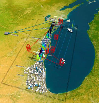
Schematic illustration of LMOS 2017 measurement assets. NASA airborne remote sensing flights (blue raster pattern) were based out of Madison, WI. Scientific Aviation airborne in situ flights (red spirals) were based out of the Sheboygan County Municipal Airport. Remote and in situ measurements were deployed at Spaceport Sheboygan, in Sheboygan WI (northern coastal site) and at the Illinois EPA monitor located within the Illinois Beach State Park in Zion, IL (southern coastal site). Additional remote sensing instruments where placed at WDNR and Illinois EPA monitoring sites along the Wisconsin shoreline coast and Chicago. Mobile measurements were also made along the Wisconsin and Illinois shoreline.