Monthly News Summary – April 2011
- Satellite View of Wisconsin Protests
- AOSS Community Poster Reception
- Science on a Sphere Acquires Earthquake Data
- Duluth NWS Using SSEC- MidWest Winter Road Conditions (WRC) Composite
- Invective Initiation Disturbs Wisconsin Climate
Satellite View of Wisconsin Protests
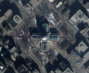
Starting Monday, 14 February 2011, protesters demonstrated at the Wisconsin State Capitol building in response to a controversial budget bill proposed by the state governor. At 10:55 am on Saturday, 19 February 2011, the GeoEye satellite “IKONOS” captured this scene from its 681 km (423 mile) orbit. The growing crowd is visible to the west (left) of the building. Police estimated a crowd of 60,000 protesters had gathered by noon. A week later the crowd reached over 100,000.
AOSS Community Poster Reception

The inaugural AOSS Community Poster Reception will be held Tuesday, 26 April 2011, in the NEW Union South from 3-6 pm. This free event showcases the innovative science, engineering, educational outreach, and other projects going on in the Atmospheric, Oceanic and Space Sciences Building.
Cash prizes will be awarded for best graduate and undergraduate posters. There will be free snacks and refreshments.
We are hoping to make this an annual event, so please help make the first one a blast! You don’t need to bring a poster, but you do need to register to attend. Please see the attached poster and visit our website to register, submit a poster, or learn more.
Science on a Sphere Acquires Earthquake Data
Rick Kohrs of the Space Science Engineering Center (SSEC) developed a data set for Science on a Sphere (SOS) 3D globe that graphically illustrates recent earthquakes around the world.
Animation of earthquakes around the world in September 2006.
Animation of earthquakes 7-13 March 2011.
The devastating Japan earthquake and tsunami occurred on 11 March 2011.
Duluth NWS Using SSEC MidWest Winter Road Conditions (WRC) Composite
In cooperation with the Wisconsin Department of Transportation (WiDOT), the Space Science and Engineering Center (SSEC) is producing a real-time display of winter road conditions for states in the upper Midwest. This display blends reports from seven independent state agencies to produce a unique view of interstate highway system.
The product is generated every 10 minutes by sampling road status reports from DOT websites and rendering the data as a unified image. This technique offers an overview of the road status independent of state boundaries. The product is is intended for cross platform independence and low band width access, offering the general public an alternate source of road conditions. Additionally, the segment set may be viewed as an overlay on various satellite and radar imagery.
The Winter Road Conditions (WRC) product is part of the Personal Advanced Weather system (PAW). The PAW product suite offers general public access to real-time weather imagery formatted for display on mobile platforms. Products offer unique access to advanced displays enhanced using the latest research conducted at the Cooperative Institute for Meteorological Satellite Studies (CIMSS) and SSEC.
Recently, the Duluth, MN, National Weather Service (NWS) added a link to the WRC product.
Invective Initiation Disturbs Wisconsin Climate
April 1, 2011 – Recent abnormally high Invective Initiation over Wisconsin has been captured in dramatic high-resolution images by advanced satellite instruments.
“The level of disturbance was far above average in the months of February and March,” said Dr. Nonpar Tisan, author of Invective Release: Change in Climate. “Basically, when such large amounts of suddenly released heat and opposing wind currents converge with such velocity and force, the energy involved creates large, wide-spread events of significant invective disturbance.”
As seen in this McIDAS-derived imagery, the Invective Initiation was not limited to the skies of Wisconsin. Dr. Tisan commented: “An invective event of this magnitude will undoubtedly affect patterns and precipitations across significant areas of the nation.”
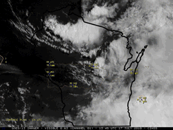
Infrared satellite footage of above-normal Invective Initiation sweeping across Wisconsin.