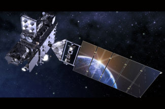
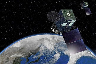
Geostationary Satellites
Research Categories | All Research Projects
We receive, process, and distribute near real-time data from GEO satellites around the Earth, which provide high temporal resolution information to monitor rapidly changing hazardous events like thunderstorms, fires, smoke, aviation turbulence, and hurricanes. These data are used to conduct research and develop applications that will benefit the nation’s environmental forecasting capabilities. Additionally, we support the research and development of current and next generation geo satellites used for environmental and weather research.
-
Atmospheric Motion Vector Research
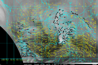
SSEC is known for its pioneering work with atmospheric motion vectors (AMVs) to track wind patterns by analyzing numerous sets of satellite images. These include AMVs from geostationary (GEO) satellite observations over mid-latitudes and the tropics and AMVs from low earth-orbiting (LEO) satellites over polar regions.
Contact:
Dave StettnerCategories:
Clouds, Geostationary Satellites, Low-Earth Orbiting Satellites -
CIMSS GOES/GOES-R LAP Validation Tool
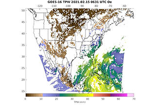
This tool validates operational GOES-R Advanced Baseline Imager (ABI) Legacy Atmospheric profile (LAP) retrieval products, focusing on parameters such as TPW, atmospheric stability indices, temperature/water vapor profiles.
Website:
https://soundingval.ssec.wisc.edu/Contact:
Zhenglong Li (PI)Categories:
Geostationary SatellitesSponsors:
NOAA -
Community Satellite Processing Package (CSPP) Geo
The Community Satellite Processing Package (CSPP) Geo is free open source software developed to support Direct Broadcast (DB) users with processing geostationary satellite data to generate geophysical products.
Website:
http://cimss.ssec.wisc.edu/csppgeo/Contact:
Graeme Martin, Ray GarciaCategories:
Geostationary Satellites, Visualization and softwareSponsors:
NOAA -
Future Weather Satellite System Design and Science Studies
Scientists will partner with NOAA to accelerate the operational readiness of new observing systems and technology in ways that reduce cost and risk.
Contact:
Brad Pierce, Tristan L’EcuyerCategories:
Geostationary Satellites, Low-Earth Orbiting SatellitesSponsors:
NOAA -
GOES-R series activities at SSEC/CIMSS
From helping to formulate the Advanced Baseline Imager, to developing algorithms and advanced products, SSEC and CIMSS scientists are now using the more timely and detailed observations of GOES-R to enhance our research of Earth’s atmosphere and weather.
Website:
https://cimss.ssec.wisc.edu/goes-r/Contact:
Mathew Gunshor, Wayne FeltzCategories:
Geostationary SatellitesSponsors:
NOAA -
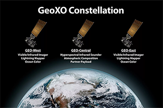
Geostationary Extended Observations (GeoXO)
Scientists will collaborate with NOAA to prepare for the next generation satellite systems beyond GOES-R, including looking at new orbits, sensors, satellite options, as well as commercial partnerships.
Contact:
Brad Pierce, Tristan L’EcuyerCategories:
Geostationary SatellitesSponsors:
NOAA -
Geostationary Hyperspectral IR Sounder
The nation’s current GOES-R series do not have a geostationary (GEO) hyperspectral IR sounder, while several international agencies have or are developing such a capability. The GEO hyperspectral IR sounders will greatly enhance the current forecast capability by providing critical high temporal resolution sounding information.
Contact:
Zhenglong Li, David TobinCategories:
Geostationary SatellitesSponsors:
NOAA -
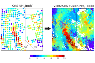
Imager and Sounder Fusion
CIMSS scientists have been investigating imager data fusion with sounder data and products to construct spectral bands and sounding products at imager spatial (and temporal for GEO) resolution.
Contact:
Elisabeth WeiszCategories:
Geostationary Satellites, Low-Earth Orbiting Satellites -
International Satellite Training
Scientists will collaborate with Taiwan Central Weather Bureau scientists to develop products for the Himawari satellite based on CIMSS’s product development experience for GOES-16 and -17.
Contact:
Mike FosterCategories:
Geostationary Satellites, TrainingSponsors:
NOAA -

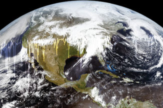
Mesoscale Winds
We are estimating wind vectors by applying an optical flow technique to one-minute imagery from GOES-16.
Contact:
Dave StettnerCategories:
Geostationary Satellites, HazardsSponsors:
NOAA -

Satellite Radiance and Sounder Data Fusion Science Projects
This project fuses low earth orbit and geostationary imager and sounder products to construct radiances and hyperspectral sounder products at improved spatial and temporal resolution for weather monitoring and forecasting operations.
Contact:
Elisabeth Weisz, Paul MenzelCategories:
Geostationary Satellites, Low-Earth Orbiting SatellitesSponsors:
NOAA