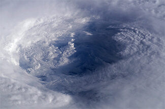
Low-Earth Orbiting Satellites
Research Categories | All Research Projects
We receive, process, and distribute near real-time data from LEO satellites around the Earth which provide high spatial resolution data important for observing wildfires, atmospheric temperature and moisture profiles, tropical cyclone structure, and flood impacts. We use these data to conduct research and develop applications that will benefit the nation’s weather forecasting capabilities. Additionally, we support the research and development of current and next generation LEO satellites used for environmental and weather research.
-
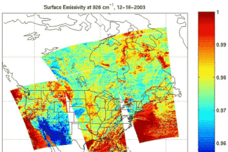
Atmospheric Infrared Sounder (AIRS)
SSEC scientists have helped calibrate the Atmospheric Infrared Sounder (AIRS) onboard the Aqua satellite and currently validate its data, develop algorithms to make the data useful, and write software for processing the data from direct broadcast facilities.
Contact:
David Tobin, Joe TaylorCategories:
Low-Earth Orbiting SatellitesSponsors:
NASA -
Atmospheric Motion Vector Research
SSEC is known for its pioneering work with atmospheric motion vectors (AMVs) to track wind patterns by analyzing numerous sets of satellite images. These include AMVs from geostationary (GEO) satellite observations over mid-latitudes and the tropics and AMVs from low earth-orbiting (LEO) satellites over polar regions.
Contact:
Dave StettnerCategories:
Clouds, Geostationary Satellites, Low-Earth Orbiting Satellites -
Community Satellite Processing Package (CSPP) Leo
The Community Satellite Processing Package (CSPP) Leo is free open source software developed to support Direct Broadcast (DB) users with processing polar-orbiting satellite data for regional products and applications.
Website:
http://cimss.ssec.wisc.edu/cspp/Contact:
Liam Gumley (PI), Kathy StrabalaCategories:
Low-Earth Orbiting Satellites, Visualization and software -
Cross-track Infrared Sounder (CrIS)
In preparation for JPSS-1 and for the current Suomi NPP, SSEC and CIMSS scientists are integrally involved in the pre-launch design and testing, as well as post-launch plans to assess the quality of the Cross-track Infrared Sounder (CrIS) data.
Contact:
David Tobin, Joe TaylorCategories:
Low-Earth Orbiting Satellites -
Future Weather Satellite System Design and Science Studies
Scientists will partner with NOAA to accelerate the operational readiness of new observing systems and technology in ways that reduce cost and risk.
Contact:
Brad Pierce, Tristan L’EcuyerCategories:
Geostationary Satellites, Low-Earth Orbiting SatellitesSponsors:
NOAA -
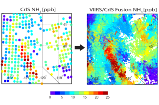
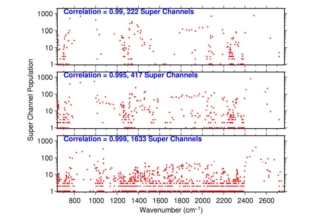
Imager and Sounder Fusion
CIMSS scientists have been investigating imager data fusion with sounder data and products to construct spectral bands and sounding products at imager spatial (and temporal for GEO) resolution.
Contact:
Elisabeth WeiszCategories:
Geostationary Satellites, Low-Earth Orbiting Satellites -
Infrared Atmospheric Sounding Interferometer/Infrared Atmospheric Sounding Interferometer Next Generation (IASI/IASI NG)
To validate the measurements and to conduct studies, SSEC researchers compare data from the Infrared Atmospheric Sounding Interferometer (IASI) on the European MetOp satellite with data from other sounders, such as the Atmospheric Infrared Sounder (AIRS) and the Cross-track Infrared Sounder (CrIS).
Contact:
David Tobin, Joe TaylorCategories:
Low-Earth Orbiting SatellitesSponsors:
NASA -
Joint Polar Satellite System (JPSS)
SSEC and CIMSS scientists are involved in calibration and validation work to ensure the instruments on board the Joint Polar Satellite System satellites return accurate measurements that will support future research.
Contact:
Lori Borg, David Tobin, Wayne FeltzCategories:
Low-Earth Orbiting Satellites -
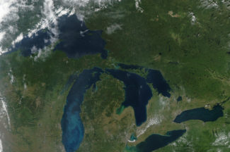
MODerate resolution Imaging Spectroradiometer (MODIS)
Scientists at SSEC use data and imagery from NASA’s MODerate Resolution Imaging Spectroradiometer (MODIS) to advance understanding of the earth-atmosphere system.
Contact:
Liam Gumley, Kathy StrabalaCategories:
Low-Earth Orbiting SatellitesSponsors:
NASA -
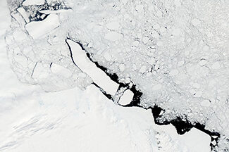
Polar Radiant Energy in the Far Infrared Experiment (PREFIRE)
Led by scientists at CIMSS, PREFIRE is a NASA Cubesat mission designed to take measurements of the Arctic with a specific focus on warming, sea ice loss, ice sheet melt and sea level rise.
Website:
https://prefire.ssec.wisc.edu/Contact:
Tristan L’EcuyerCategories:
Low-Earth Orbiting Satellites, Polar ResearchSponsors:
NASA -
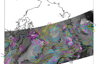
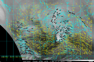
Polar Winds
The Visible Infrared Imaging Radiometer Suite (VIIRS), the MODerate-resolution Imaging Spectroradiometer (MODIS), and the Advanced Very High Resolution Radiometer (AVHRR) are being used to generate high-latitude wind fields by tracking cloud and water vapor features in infrared window and water vapor bands with these applications expanded to LEO-GEO and Sounder based winds.
Contact:
Dave Santek, Rich DworakCategories:
Low-Earth Orbiting Satellites, Polar ResearchSponsors:
NOAA -

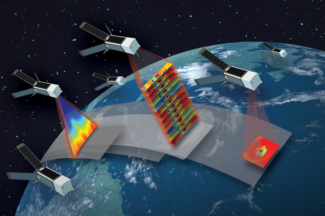
Satellite Radiance and Sounder Data Fusion Science Projects
This project fuses low earth orbit and geostationary imager and sounder products to construct radiances and hyperspectral sounder products at improved spatial and temporal resolution for weather monitoring and forecasting operations.
Contact:
Elisabeth Weisz, Paul MenzelCategories:
Geostationary Satellites, Low-Earth Orbiting SatellitesSponsors:
NOAA -
Time-Resolved Observations of Precipitation structure and storm Intensity with a Constellation of Smallsats (TROPICS)
The Time-Resolved Observations of Precipitation structure and storm Intensity with a Constellation of Smallsats (TROPICS) project employs 4 nanosatellites called CubeSats to study tropical cyclones via rapid sampling microwave observations. The CIMSS Tropical Cyclone research group is charged with developing methods to estimate storm intensity from this data.
Website:
https://tropics.ssec.wisc.edu/Contact:
Derrick HerndonCategories:
Low-Earth Orbiting Satellites, Tropical CyclonesSponsors:
NASA -
Tropical Cyclone ML/AI Research (TC ML/AI)
CIMSS scientists have been investigating how they can use AI to improve short-term forecasts of hurricanes, and in particular their intensity.
Contact:
Tony Wimmers, Sarah Griffin